|
|
Hurricane pictures / summaries 2017
Satellite images provided by NOAA / NASA / MODIS / CIRA. Hurricane tracks courtesy of the National Hurricane Center.
 Click pictures for close up view Click pictures for close up view
|
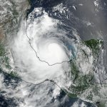
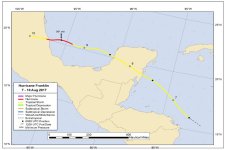
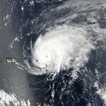
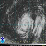
Hurricane Franklin
August 9,2017
Franklin was upgraded to a tropical storm in the western Caribbean on August 6th east of Belize. It moved NW and made landfall on the southeastern Yucatan as a tropical storm. It crossed the Yucatan and restrengthened as it moved west across the Bay of Campeche. Franklin strengthened to 85 mph before making another landfall on the northeastern Mexican coast Wednesday night.
|
|
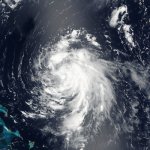
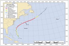
Hurricane Gert
August 13, 2017
Gert formed northeast of the Bahamas and did not affect any land. It was classified on August 13th as a tropical storm and strengthened to a 100 mph hurricane on the 17th as before turning northeast and becoming extratropical well east of the Mid Atlantic coast.
|
|
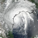
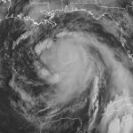
Hurricane Harvey
August 25, 2017
Hurricane Harvey will go down as the 2nd costliest hurricane in U.S. history. Officially classified as a category 4 hurricane, the main damage was not from wind or storm tides, but epic amounts of rainfall over southeast Texas. It now holds the record for the heaviest rainfall produced by a tropical cyclone in the U.S. with Jefferson county reporting 60.5". The strongest wind gust was 143 mph measured at the Aransas county airport. Harvey stalled inland from the central Texas coast, allowing for days of moisture to pour in from the Gulf.
Click here for Hurricane Harvey facts and complete summary.
|
|
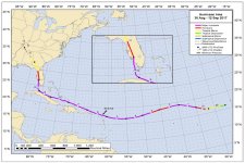
Hurricane Irma
September 5, 2017
Irma began just west of the Cabo Verde Islands off of the west coast of Africa. It was classified as a tropical storm on August 30th. It rapidly strengthened into a major hurricane before briefly losing some strength. High pressure to the north built and forced Irma southwest as it strenthened again. It became a category 5 hurricane and reached top sustained winds of 185 mph at it moved over the Barbuda and Leeward Islands. Irma was the second strongest hurricane in the Atlantic basin on record.
Irma inflicted great damage to the Leeward islands. It continued west, just north of the greater Antilles bringing wind damage and flooding to those islands. On September 10 it turned north over the Florida Keys also inflicting severe damage. Top sustained winds were estimated at 130 mph. Irma moved straight up the Florida peninsula weakening into southwest Georgia. Beach erosion and in some locations record high tides were seen along the east coast of Florida north into Georgia. Wind damage was also seen into north Georgia with tropical storm wind gusts.
Click here for Hurricane Irma facts and complete summary.
|
|
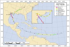
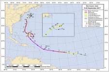
Hurricane Jose
September 9, 2017
Jose also formed in the deep tropics in the eastern North Atlantic as Irma , but farther southwest of the Cabo Verde islands. It steadliy strengthened as it moved WNW toward the Leeward islands. It also became a strong category 4 hurricane threatening the eastern Caribbean only a number of days after a direct strike. Jose turned just before reaching Barbuda, thus only bringing minimal effects to the Leewards. Jose continued northward and gradually lost tropical characteristics well east of the U.S. Mid Atlantic coast.
|
|
|
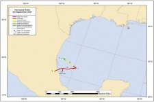
Hurricane Katia
September 9, 2017
Katia formed in the western Bay of Campeche and had a very short life span. It started with a large burst of deep convection, but soon weakened. It regained strength with top sustained winds of 105 mph just before landfall on September 8th. It was a small system as it made landfall.
|

|
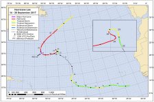
Hurricane Lee
September 24, 2017
Lee was a long wandering tropical cyclone that did not impact land. It formed in the deep tropics south of the Cabo Verde islands. It remained weak the first week of its lifespan as it moved north into the central North Atlantic. It stalled and rapidly developed into a major hurricane. It was at first a very small hurricane, then developed a classic eye structure. It gradually lost tropical characteristics as it moved over the colder northern North Atlantic.
|

|
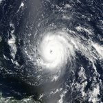
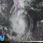
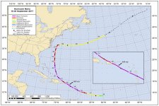
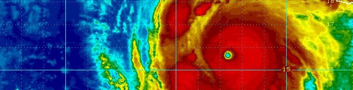
Hurricane Maria
September 19, 2017
Maria was the 5th strongest tropical cyclone to make landfall in the United States / U.S. terriories with top sustained winds of 155 mph at landfall on the southeast coast of Puerto Rico. It formed east of the Lesser Antilles and moved NW directly over the island of Dominica as a category 5 hurricane with winds of 160 mph.
Maria continued NW and winds strenghtend to 175 mph with a central pressure of 908 MB. This means that Maria was the 9th most intense Atlantic hurricane on record and the 4th strongest measured by windspeed.
It passed barely SE of St. Croix, near southern Vieques then making landfall over Puerto Rico on September 20th. Maria moved north brushing the Turks and Caicos. Steering winds keep it east of the U.S. coast over the next several days, as large swell visted the eastern coast.
Click here for Hurricane Maria facts and complete summary.
|
|
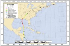
Hurricane Nate
October 7, 2017
Nate formed from a disturbance east of Nicaragua on October 4th. It moved north and was classified as a minimal tropical storm as it made landfall over eastern Nicaragua and Honduras. It began to organize quickly as it moved through the Yucatan Channel and picked up forward speed to over 25 mph. Nate became a 90 mph hurricane in the central Gulf. Nate made landfall on the Mouth of the Mississippi River the evening of the 7th and at Biloxi early the next morning.
|
|
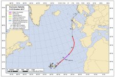
Hurricane Ophelia
October 11, 2017
Ophelia gradually organized in the open Atlantic well southwest of the Azores. Despite being over somewhat cool water, it became a category 3 hurricane at 115 mph on the 14th. It continued NE and moved over Ireland as an extratropical cyclone. It was the strongest storm in at least 30 years with wind gusts over hurricane force. Aberdaron gusted to 87 mph.
|
Hurricane pictures and summaries main page.
|
|
|
)
)
)
)
)
)
)
)
)
)
)
)
)
)
)
)
)
)
)
)