Milton

Tropical cyclone archives of the 2024 Atlantic hurricane season
User avatar
Tropical Inspector
Site Admin
Site Admin
Posts: 3697
Joined: Tue Feb 20, 2007 2:28 pm
Antispam: no
Location: Under a palm tree
Contact:

Milton

Post by Tropical Inspector »

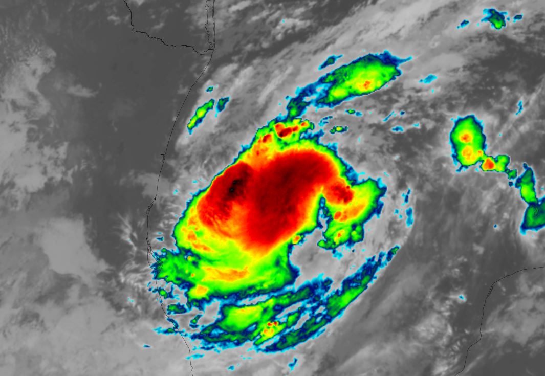
Saturday Evening Update
Milton forms

A disturbed area of weather in the southwestern Gulf of Mexico has become tropical storm Milton today. IR satellite imagery shows cold cloud tops and favorable upper air conditions for strengthening

The Weather Situation
SUMMARY OF 400 PM CDT...2100 UTC...INFORMATION
----------------------------------------------
LOCATION...22.7N 95.5W
ABOUT 245 MI...395 KM N OF VERACRUZ MEXICO
ABOUT 385 MI...615 KM WNW OF PROGRESO MEXICO
MAXIMUM SUSTAINED WINDS...40 MPH...65 KM/H
PRESENT MOVEMENT...NNE OR 20 DEGREES AT 3 MPH...6 KM/H
MINIMUM CENTRAL PRESSURE...1006 MB...29.71 INCHES

Tropicast: Visible Satellite RAMMB / CIRA Slider Saturday Evening
Image

Tropical Weather Forecast:
Milton is likely to greatly intensify and possibly become a major hurricane. The coast of Florida west of the peninsula should follow that latest information on Milton and prepare accordingly. Milton potentially poses a great risk to the Tampa Bay area and adjacent coastlines. High surge, damaging winds, flash flooding and isolated tornadoes are possible.
Rich Johnson
Twitter: https://twitter.com/richjohnsonwx
Certified Broadcast Meteorologist - Hurricane Expert
User avatar
Tropical Inspector
Site Admin
Site Admin
Posts: 3697
Joined: Tue Feb 20, 2007 2:28 pm
Antispam: no
Location: Under a palm tree
Contact:

Re: Milton

Post by Tropical Inspector »

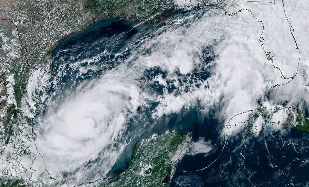
Sunday Morning Update
Milton predicted toward western Florida coast

Milton is slowly organizing. IR satellite imagery is similar to last night with some growth in convection.

The Weather Situation
SUMMARY OF 400 AM CDT...0900 UTC...INFORMATION
----------------------------------------------
LOCATION...23.0N 94.9W
ABOUT 355 MI...565 KM WNW OF PROGRESO MEXICO
ABOUT 845 MI...1360 KM WSW OF TAMPA FLORIDA
MAXIMUM SUSTAINED WINDS...50 MPH...85 KM/H
PRESENT MOVEMENT...E OR 90 DEGREES AT 5 MPH...7 KM/H
MINIMUM CENTRAL PRESSURE...1003 MB...29.62 INCHES

Tropicast: Visible Satellite RAMMB / CIRA Slider Sunday Morning
Image

Tropical Weather Forecast:
Milton is likely to greatly intensify and possibly become a major hurricane. There is a large spread in intensity is forecast models at this time. It is NOT known if this potential hurricane will reach the coast as a major hurricane or will be weakened some by possible shear as it approaches the coast. Preparations should always be based on a worst case scenario. The coast of Florida west of the peninsula should follow that latest information on Milton and prepare accordingly. Milton potentially poses a great risk to the Tampa Bay area and adjacent coastlines. High surge, damaging winds, flash flooding and isolated tornadoes are possible.

Forecast models also are differing on the exact landfall location, but do not just focus on the center of the track as effects can be seen many miles away.
Rich Johnson
Twitter: https://twitter.com/richjohnsonwx
Certified Broadcast Meteorologist - Hurricane Expert
User avatar
Tropical Inspector
Site Admin
Site Admin
Posts: 3697
Joined: Tue Feb 20, 2007 2:28 pm
Antispam: no
Location: Under a palm tree
Contact:

Re: Milton

Post by Tropical Inspector »

Sunday Late Afternoon Update
Milton becomes a hurricane

IR satellite imagery shows very high cloud tops indicating significant strengthening today. The central dense overcast has a general circular appearance, but it quickly becoming more well defined.

The Weather Situation
SUMMARY OF 400 PM CDT...2100 UTC...INFORMATION
----------------------------------------------
LOCATION...22.4N 93.8W
ABOUT 275 MI...440 KM WNW OF PROGRESO MEXICO
ABOUT 805 MI...1295 KM WSW OF TAMPA FLORIDA
MAXIMUM SUSTAINED WINDS...85 MPH...140 KM/H
PRESENT MOVEMENT...E OR 100 DEGREES AT 7 MPH...11 KM/H
MINIMUM CENTRAL PRESSURE...983 MB...29.03 INCHES

Tropicast: Visible Satellite RAMMB / CIRA Slider Sunday Late Afternoon
Image

Tropical Weather Forecast:
Milton is intensifying and will likely become a major hurricane. It is NOT known if this potential hurricane will reach the coast as a major hurricane or will be weakened some by possible shear as it approaches the coast. Preparations should always be based on a worst case scenario. The coast of Florida west of the peninsula should follow that latest information on Milton and prepare accordingly. Milton potentially poses a great risk to the Tampa Bay area and adjacent coastlines. High surge, damaging winds, flash flooding and isolated tornadoes are possible.

Forecast models also are differing on the exact landfall location, but do not just focus on the center of the track as effects can be seen many miles away.
Rich Johnson
Twitter: https://twitter.com/richjohnsonwx
Certified Broadcast Meteorologist - Hurricane Expert
User avatar
Tropical Inspector
Site Admin
Site Admin
Posts: 3697
Joined: Tue Feb 20, 2007 2:28 pm
Antispam: no
Location: Under a palm tree
Contact:

Re: Milton

Post by Tropical Inspector »

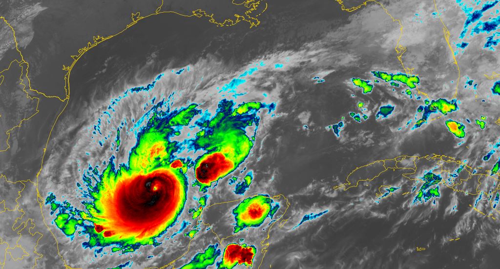
Monday Morning Update
Milton rapidly intensifying

IR satellite shows very high cloud tops and a small eye. Milton is fighting some shear but is expected to gain much more strength over the southern Gulf of Mexico. IMO, Milton is stronger than a 100 mph hurricane at this time and may be approaching major strength at 110 mph or more.

The Weather Situation
SUMMARY OF 400 AM CDT...0900 UTC...INFORMATION
----------------------------------------------
LOCATION...22.1N 92.6W
ABOUT 195 MI...310 KM WNW OF PROGRESO MEXICO
ABOUT 750 MI...1210 KM WSW OF TAMPA FLORIDA
MAXIMUM SUSTAINED WINDS...100 MPH...155 KM/H
PRESENT MOVEMENT...ESE OR 105 DEGREES AT 8 MPH...13 KM/H
MINIMUM CENTRAL PRESSURE...972 MB...28.71 INCHES

Tropicast: IR Satellite RAMMB / CIRA Slider Monday Morning
Image

Tropical Weather Forecast:
Milton is intensifying and will become a major hurricane soon. It will face weakening shear before reaching the Florida coast but still very well may reach the coast as a major hurricane. Preparations should always be based on a worst case scenario. The coast of Florida west of the peninsula should follow that latest information on Milton and prepare accordingly. Milton potentially poses a great risk to the Tampa Bay area and adjacent coastlines. High surge, damaging winds, flooding and isolated tornadoes are possible.

Forecast models also are differing on the exact landfall location, but do not just focus on the center of the track as effects can be seen many miles away.
Rich Johnson
Twitter: https://twitter.com/richjohnsonwx
Certified Broadcast Meteorologist - Hurricane Expert
User avatar
Tropical Inspector
Site Admin
Site Admin
Posts: 3697
Joined: Tue Feb 20, 2007 2:28 pm
Antispam: no
Location: Under a palm tree
Contact:

Re: Milton

Post by Tropical Inspector »

NHC updated to major hurricane at 7 am edt

SUMMARY OF 600 AM CDT...1100 UTC...INFORMATION
----------------------------------------------
LOCATION...21.9N 92.4W
ABOUT 180 MI...285 KM WNW OF PROGRESO MEXICO
ABOUT 750 MI...1210 KM WSW OF TAMPA FLORIDA
MAXIMUM SUSTAINED WINDS...120 MPH...195 KM/H
PRESENT MOVEMENT...ESE OR 105 DEGREES AT 8 MPH...13 KM/H
MINIMUM CENTRAL PRESSURE...954 MB...28.17 INCHES
Rich Johnson
Twitter: https://twitter.com/richjohnsonwx
Certified Broadcast Meteorologist - Hurricane Expert
User avatar
Tropical Inspector
Site Admin
Site Admin
Posts: 3697
Joined: Tue Feb 20, 2007 2:28 pm
Antispam: no
Location: Under a palm tree
Contact:

Re: Milton

Post by Tropical Inspector »

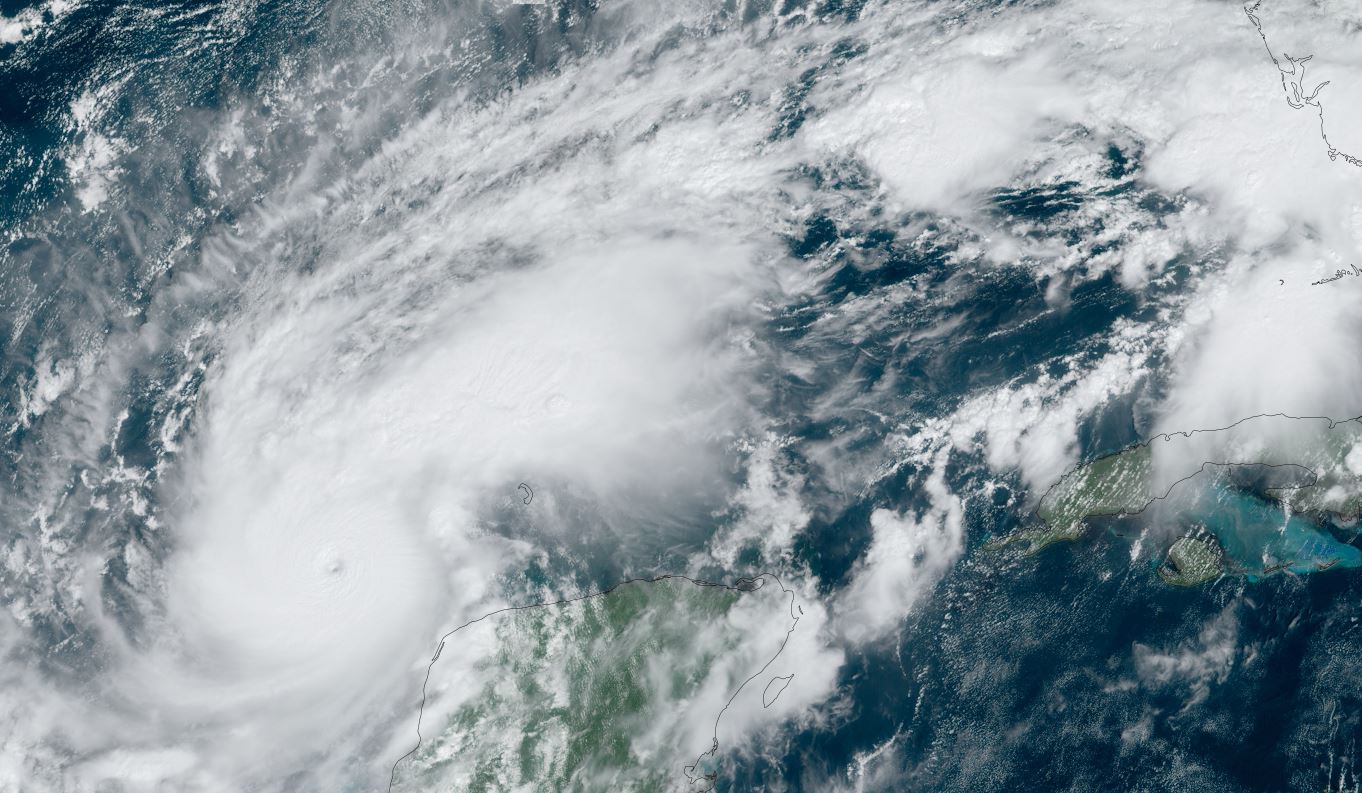
Monday Midday Update
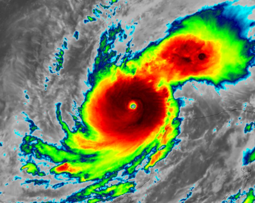
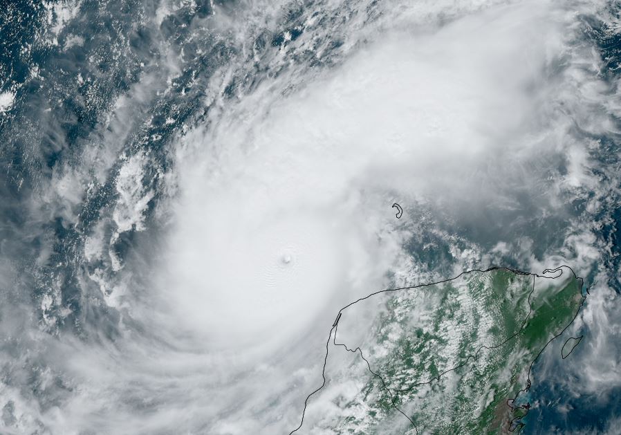
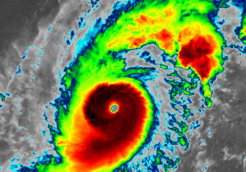
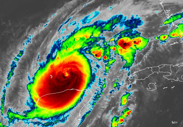
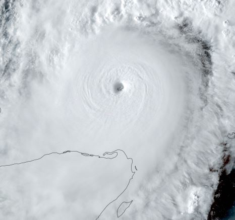
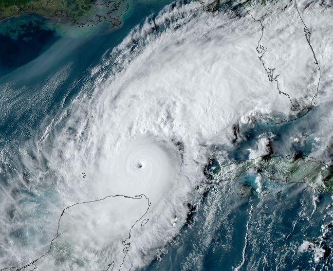
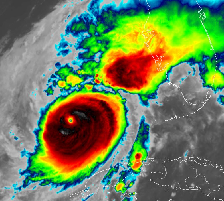
Milton a cat 5

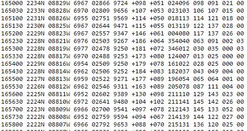
Reconnaisanice aircraft recently found winds over 200 mph with Milton.

The Weather Situation
SUMMARY OF 1055 AM CDT...1555 UTC...INFORMATION
-----------------------------------------------
LOCATION...21.7N 91.6W
ABOUT 125 MI...200 KM WNW OF PROGRESO MEXICO
ABOUT 715 MI...1150 KM SW OF TAMPA FLORIDA
MAXIMUM SUSTAINED WINDS...160 MPH...250 KM/H
PRESENT MOVEMENT...ESE OR 110 DEGREES AT 9 MPH...15 KM/H
MINIMUM CENTRAL PRESSURE...925 MB...27.31 INCHES


Tropicast: Visible Satellite RAMMB / CIRA Slider Monday Midday
Image

Tropicast: IR Satellite RAMMB / CIRA Slider Monday Midday
Image

Tropicast: Recon message
Image

Tropicast: Recon vortex message
Image

Tropical Weather Forecast:
Milton will face increasing shear before reaching the Florida coast but still very well may reach the coast as a major hurricane. Preparations should always be based on a worst case scenario. The coast of Florida west of the peninsula should follow that latest information on Milton and prepare accordingly. Milton potentially poses a great risk to the Tampa Bay area and adjacent coastlines. High surge, damaging winds, flooding and isolated tornadoes are possible.

Forecast models also are differing on the exact landfall location, but do not just focus on the center of the track as effects can be seen many miles away.
Rich Johnson
Twitter: https://twitter.com/richjohnsonwx
Certified Broadcast Meteorologist - Hurricane Expert
User avatar
Tropical Inspector
Site Admin
Site Admin
Posts: 3697
Joined: Tue Feb 20, 2007 2:28 pm
Antispam: no
Location: Under a palm tree
Contact:

Re: Milton

Post by Tropical Inspector »

Monday Late Afternoon Update
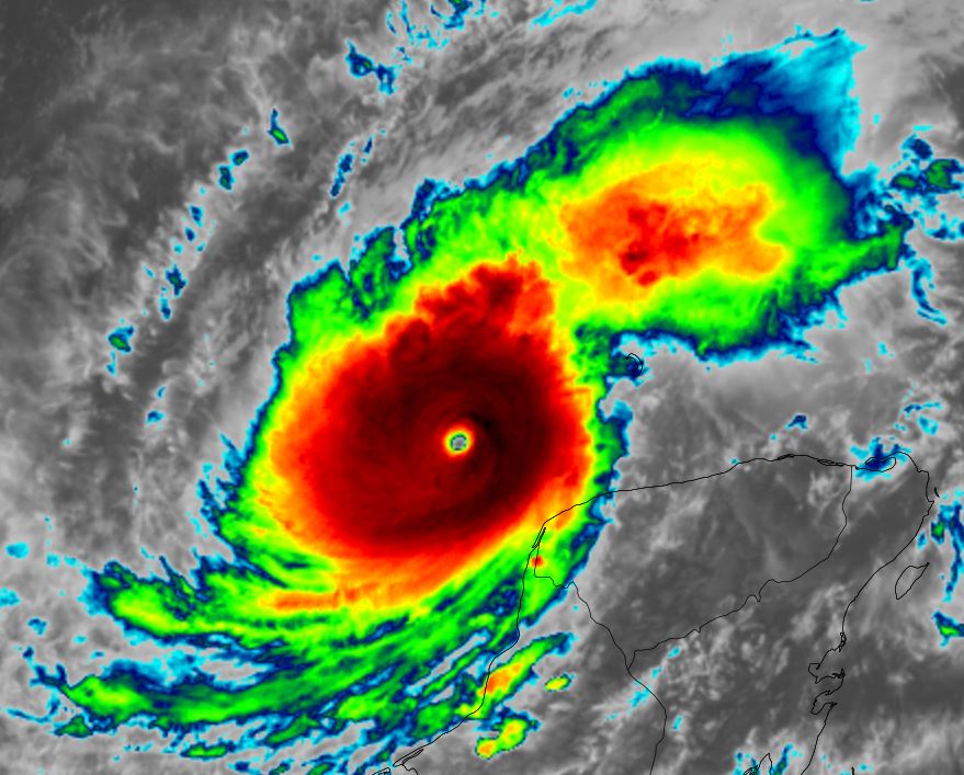
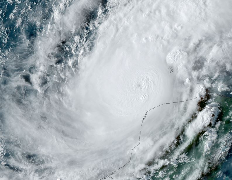
Milton still stronger

Milton will continue to strengthen into tonight. A second eyewall is trying to form which would cause this strengthening phase to pause or terminate.

The Weather Situation
SUMMARY OF 400 PM CDT...2100 UTC...INFORMATION
----------------------------------------------
LOCATION...21.8N 90.8W
ABOUT 80 MI...125 KM WNW OF PROGRESO MEXICO
ABOUT 675 MI...1085 KM SW OF TAMPA FLORIDA
MAXIMUM SUSTAINED WINDS...180 MPH...285 KM/H
PRESENT MOVEMENT...E OR 90 DEGREES AT 10 MPH...17 KM/H
MINIMUM CENTRAL PRESSURE...905 MB...26.73 INCHES


Tropicast: Visible Satellite RAMMB / CIRA Slider Monday Afternoon
Image

Tropicast: IR Satellite RAMMB / CIRA Slider Monday Afternoon
Image

Tropical Weather Forecast:
Milton will face increasing shear before reaching the Florida coast, but will likely reach the coast as a major hurricane. Preparations should always be based on a worst case scenario. The coast of Florida west of the peninsula should follow that latest information on Milton and prepare accordingly. Milton potentially poses a great risk to the Tampa Bay area and adjacent coastlines. High surge, damaging winds, flooding and isolated tornadoes are possible.

Forecast models are beginning to consolidate with bringing Milton inland near the Tampa Bay area, but do not just focus on the center of the track as effects can be seen many miles away.
Rich Johnson
Twitter: https://twitter.com/richjohnsonwx
Certified Broadcast Meteorologist - Hurricane Expert
User avatar
Tropical Inspector
Site Admin
Site Admin
Posts: 3697
Joined: Tue Feb 20, 2007 2:28 pm
Antispam: no
Location: Under a palm tree
Contact:

Re: Milton

Post by Tropical Inspector »

Monday Evening Update
Milton still stronger

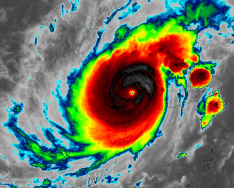
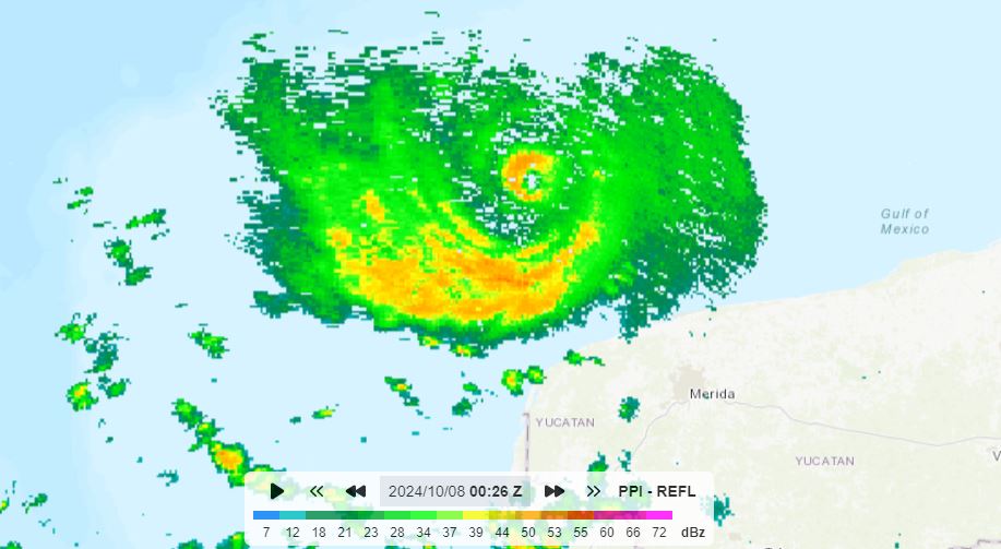
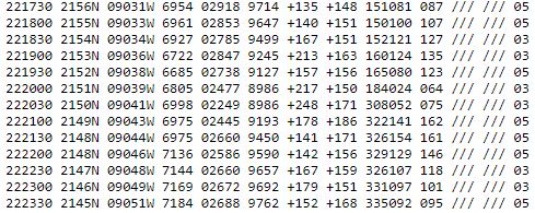
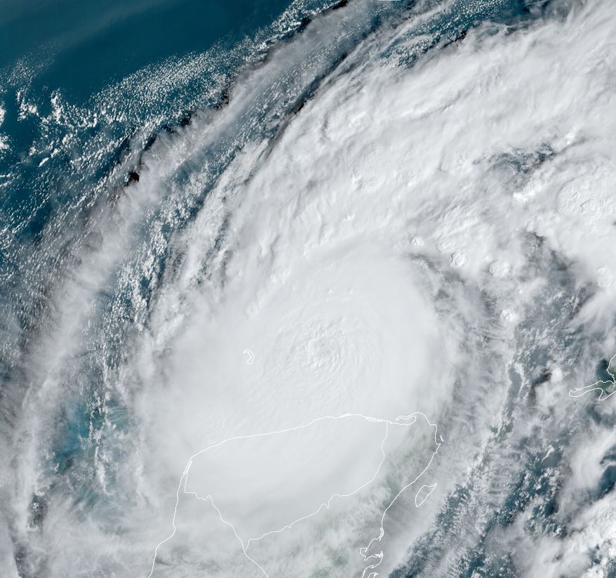
Hurricane Hunter reconnaissance aircraft measured a near record low pressure from Milton a short while ago. Since then, pressure has risen slightly. Satellite presentation shows a classic looking hurricane with a thick eyewall. The eye is small and it is likely that a second outer eyewall may form which would curb strengthening..

The Weather Situation
SUMMARY OF 700 PM CDT...0000 UTC...INFORMATION
----------------------------------------------
LOCATION...21.9N 90.4W
ABOUT 60 MI...100 KM NW OF PROGRESO MEXICO
ABOUT 650 MI...1045 KM SW OF TAMPA FLORIDA
MAXIMUM SUSTAINED WINDS...180 MPH...285 KM/H
PRESENT MOVEMENT...E OR 90 DEGREES AT 10 MPH...17 KM/H
MINIMUM CENTRAL PRESSURE...897 MB...26.49 INCHES


Tropicast: Visible Satellite RAMMB / CIRA Slider Monday Evening
Image

Tropicast: IR Satellite RAMMB / CIRA Slider Monday Evening
Image

Tropicast: Mexico Radar of the Yucatan 7:30 pm cdt
Image

Tropicast: Recon report showing the near record pressure
Image

Tropical Weather Forecast:
Milton will face increasing shear before reaching the Florida coast, but will likely reach the coast as a major hurricane. Preparations should always be based on a worst case scenario. The coast of Florida west of the peninsula should follow that latest information on Milton and finish preparations by Tuesday. Milton potentially poses a great risk to the Tampa Bay area and adjacent coastlines. High surge, damaging winds, flooding and isolated tornadoes are possible.

Forecast models are beginning to consolidate with bringing Milton inland near the Tampa Bay area, but do not just focus on the center of the track as effects can be seen many miles away.
Rich Johnson
Twitter: https://twitter.com/richjohnsonwx
Certified Broadcast Meteorologist - Hurricane Expert
User avatar
Tropical Inspector
Site Admin
Site Admin
Posts: 3697
Joined: Tue Feb 20, 2007 2:28 pm
Antispam: no
Location: Under a palm tree
Contact:

Re: Milton

Post by Tropical Inspector »

Tuesday Midday Update
Milton weakens, then strengthens again

It appears that Milton was going through an eyewall replacement cycle as it had weakened for several hours. It is picking up a little strength again before weakening with increasing shear tomorrow

The Weather Situation
SUMMARY OF 100 PM CDT...1800 UTC...INFORMATION
----------------------------------------------
LOCATION...22.5N 88.2W
ABOUT 125 MI...205 KM NE OF PROGRESO MEXICO
ABOUT 520 MI...840 KM SW OF TAMPA FLORIDA
MAXIMUM SUSTAINED WINDS...155 MPH...250 KM/H
PRESENT MOVEMENT...ENE OR 65 DEGREES AT 8 MPH...13 KM/H
MINIMUM CENTRAL PRESSURE...923 MB...27.26 INCHES


Tropicast: Visible Satellite RAMMB / CIRA Slider Tuesday Afternoon
Image

Tropicast: Visible Satellite RAMMB / CIRA Slider Tuesday Morning
Image

Tropicast: IR Satellite RAMMB / CIRA Slider Tuesday Afternoon
Image

Tropicast: IR Satellite RAMMB / CIRA Slider Tuesday Morning
Image

Tropicast: Recon report Tuesday Afternoon
Image

Tropical Weather Forecast:
Milton will face increasing shear before reaching the Florida coast, but will likely reach the coast as a major hurricane. Preparations should always be based on a worst case scenario. The coast of Florida west of the peninsula should follow that latest information on Milton and finish preparations by Tuesday. Milton potentially poses a great risk to the Tampa Bay area and adjacent coastlines. High surge, damaging winds, flooding and isolated tornadoes are possible.

Forecast models continue to bring Milton inland near the Tampa Bay area late Wednesday evening, but do not just focus on the center of the track as effects can be seen many miles away.
Rich Johnson
Twitter: https://twitter.com/richjohnsonwx
Certified Broadcast Meteorologist - Hurricane Expert
User avatar
Tropical Inspector
Site Admin
Site Admin
Posts: 3697
Joined: Tue Feb 20, 2007 2:28 pm
Antispam: no
Location: Under a palm tree
Contact:

Re: Milton

Post by Tropical Inspector »

Tuesday Evening Update
Milton strengthens again

Hurricane Hunter aircraft discovered that pressure dropped to 902 mb, nearly as low at it's lowest yesterday. Winds have also rebounded, but not to the level seen on Monday.

The Weather Situation
SUMMARY OF 700 PM CDT...0000 UTC...INFORMATION
----------------------------------------------
LOCATION...23.0N 86.9W
ABOUT 280 MI...450 KM WSW OF THE DRY TORTUGAS
ABOUT 440 MI...710 KM SW OF TAMPA FLORIDA
MAXIMUM SUSTAINED WINDS...165 MPH...270 KM/H
PRESENT MOVEMENT...ENE OR 70 DEGREES AT 10 MPH...17 KM/H
MINIMUM CENTRAL PRESSURE...902 MB...26.64 INCHES

Tropicast: Visible Satellite RAMMB / CIRA Slider Tuesday Late Afternoon
Image

Tropicast: Visible Satellite RAMMB / CIRA Slider Tuesday Late Afternoon
Image

Tropicast: IR Satellite RAMMB / CIRA Slider Tuesday Evening
Image

Tropicast: Recon report Tuesday Evening
Image

Tropical Weather Forecast:
Milton will face increasing shear before reaching the Florida coast, but will likely reach the coast as a major hurricane. Preparations should be finished. Milton poses a great risk to the Tampa Bay area and adjacent coastlines, especially just south of Tampa Bay. High surge, damaging winds, flooding and isolated tornadoes are possible.

Forecast models continue to bring Milton inland near the Tampa Bay area late Wednesday evening, but do not just focus on the center of the track as effects can be seen many miles away.
Rich Johnson
Twitter: https://twitter.com/richjohnsonwx
Certified Broadcast Meteorologist - Hurricane Expert
User avatar
Tropical Inspector
Site Admin
Site Admin
Posts: 3697
Joined: Tue Feb 20, 2007 2:28 pm
Antispam: no
Location: Under a palm tree
Contact:

Re: Milton

Post by Tropical Inspector »

Wednesday Morning Update
Milton still a cat 5

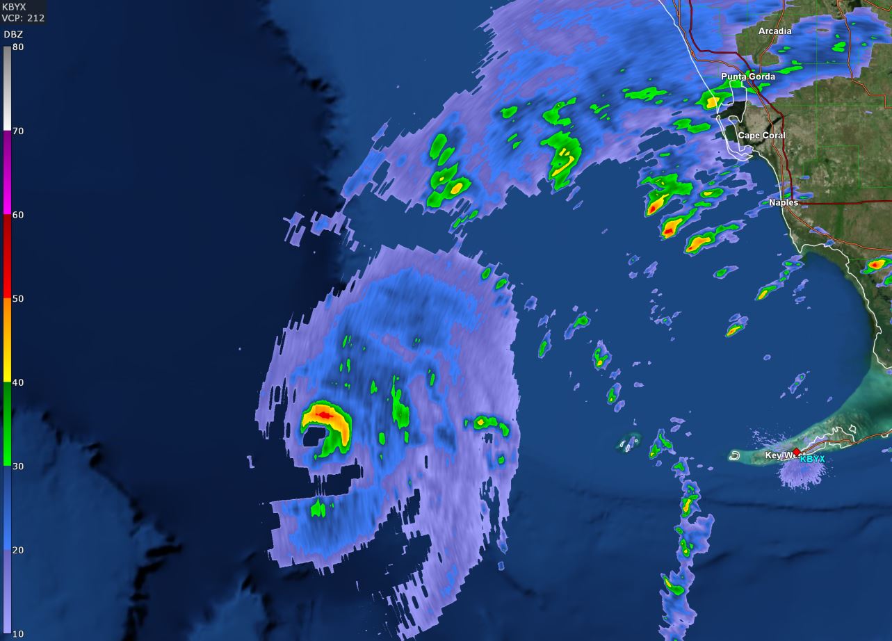
Hurricane Hunter aircraft from early this morning continue to show that Milton is a catastrophic category 5 hurricane. Pressure has risen some during the last pass, but is still extremely low. IR satellite imagery shows only minimal shear to the NW. The eyewall remains intake and thick at this time.

The Weather Situation
SUMMARY OF 400 AM CDT...0900 UTC...INFORMATION
----------------------------------------------
LOCATION...24.5N 85.4W
ABOUT 160 MI...255 KM W OF THE DRY TORTUGAS
ABOUT 300 MI...485 KM SW OF TAMPA FLORIDA
MAXIMUM SUSTAINED WINDS...160 MPH...260 KM/H
PRESENT MOVEMENT...NE OR 45 DEGREES AT 14 MPH...22 KM/H
MINIMUM CENTRAL PRESSURE...907 MB...26.78 INCHES

Tropicast: IR Satellite RAMMB / CIRA Slider Early Wednesday Morning
Image

Tropicast: GR Level 3 Radar Key West 6:18am Wednesday Morning
Image

Tropicast: Recon report Early Wednesday Morning
Image

Tropical Weather Forecast:
Milton poses a great risk to the Tampa Bay area and adjacent coastlines, especially just south of Tampa Bay. High surge, damaging winds, flooding and isolated tornadoes are possible.

Forecast models continue to bring Milton inland near the Tampa Bay area or possibly just south of the Bay late Wednesday evening, but do not just focus on the center of the track as effects can be seen many miles away.
Rich Johnson
Twitter: https://twitter.com/richjohnsonwx
Certified Broadcast Meteorologist - Hurricane Expert
User avatar
Tropical Inspector
Site Admin
Site Admin
Posts: 3697
Joined: Tue Feb 20, 2007 2:28 pm
Antispam: no
Location: Under a palm tree
Contact:

Re: Milton

Post by Tropical Inspector »

Wednesday Midday Update
Milton weakening, but still very dangerous

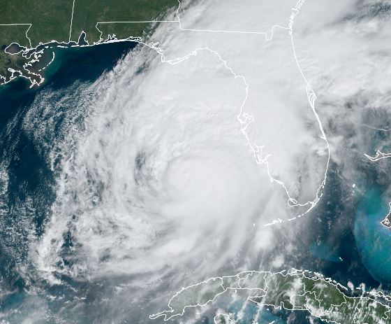
Hurricane Hunter aircraft is showing pressure rising and winds which are starting to weaken. Milton remains a very dangerous hurricane despite this! Tornadic supercells are now moving near the west coast of Florida as the first band is moving inland.

The Weather Situation
SUMMARY OF 1100 AM EDT...1500 UTC...INFORMATION
-----------------------------------------------
LOCATION...25.8N 84.3W
ABOUT 160 MI...255 KM WSW OF FT. MYERS FLORIDA
ABOUT 190 MI...305 KM SW OF TAMPA FLORIDA
MAXIMUM SUSTAINED WINDS...145 MPH...230 KM/H
PRESENT MOVEMENT...NE OR 35 DEGREES AT 17 MPH...28 KM/H
MINIMUM CENTRAL PRESSURE...931 MB...27.50 INCHES

Tropicast: Visible Satellite RAMMB / CIRA Slider Early Wednesday Afternoon
Image

Tropicast: IR Satellite RAMMB / CIRA Slider Early Wednesday Afternoon
Image

Tropicast: GR Level 3 Radar Tampa 12:13pm Wednesday Afternoon
Image

Tropical Weather Forecast:
Milton poses a great risk to the Tampa Bay area and adjacent coastlines, especially just south of Tampa Bay. High surge, damaging winds, flooding and isolated tornadoes are possible. It now appears that from Bradenton south to Ft. Myers will see the highest surge. Refer to official NHC local statements.

Forecast models continue to bring Milton inland near the Tampa Bay area or possibly just south of the Bay late Wednesday evening, but do not just focus on the center of the track as effects can be seen many miles away.
Rich Johnson
Twitter: https://twitter.com/richjohnsonwx
Certified Broadcast Meteorologist - Hurricane Expert
User avatar
Tropical Inspector
Site Admin
Site Admin
Posts: 3697
Joined: Tue Feb 20, 2007 2:28 pm
Antispam: no
Location: Under a palm tree
Contact:

Re: Milton

Post by Tropical Inspector »

Wednesday Late Afternoon Update
Milton continues weakening, but still very dangerous

Hurricane Hunter aircraft continues to show pressure rising and the structure deteriorating. Milton remains a very dangerous hurricane! Despite the winds beginning to lower some, surge will still be high from near Tampa Bay and especially south from the coast near Bradenton to Sarasota.

The Weather Situation
SUMMARY OF 500 PM EDT...2100 UTC...INFORMATION
----------------------------------------------
LOCATION...26.9N 83.4W
ABOUT 60 MI...100 KM WSW OF SARASOTA FLORIDA
ABOUT 170 MI...275 KM SW OF ORLANDO FLORIDA
MAXIMUM SUSTAINED WINDS...120 MPH...195 KM/H
PRESENT MOVEMENT...NE OR 35 DEGREES AT 17 MPH...28 KM/H
MINIMUM CENTRAL PRESSURE...948 MB...28.00 INCHES

Tropicast: Visible Satellite RAMMB / CIRA Slider Late Wednesday Afternoon
Image

Tropicast: IR Satellite RAMMB / CIRA Slider Late Wednesday Afternoon
Image

Tropicast: GR Level 3 Radar Tampa 5 pm Wednesday Afternoon
Image

Tropical Weather Forecast:
Milton poses a great risk to the Tampa Bay area and adjacent coastlines, especially just south of Tampa Bay. High surge, damaging winds, flooding and isolated tornadoes are possible. It now appears that from Bradenton south to Ft. Myers will see the highest surge. Refer to official NHC local statements.

Radar shows that Milton will be approaching landfall later this evening just south of Tampa Bay near Longboat Key. Remember - the effects will also be seen far from where the center crosses.
Rich Johnson
Twitter: https://twitter.com/richjohnsonwx
Certified Broadcast Meteorologist - Hurricane Expert
User avatar
Tropical Inspector
Site Admin
Site Admin
Posts: 3697
Joined: Tue Feb 20, 2007 2:28 pm
Antispam: no
Location: Under a palm tree
Contact:

Re: Milton

Post by Tropical Inspector »

Wednesday Evening Update
Milton making landfall soon

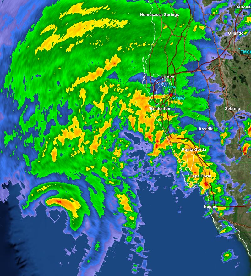
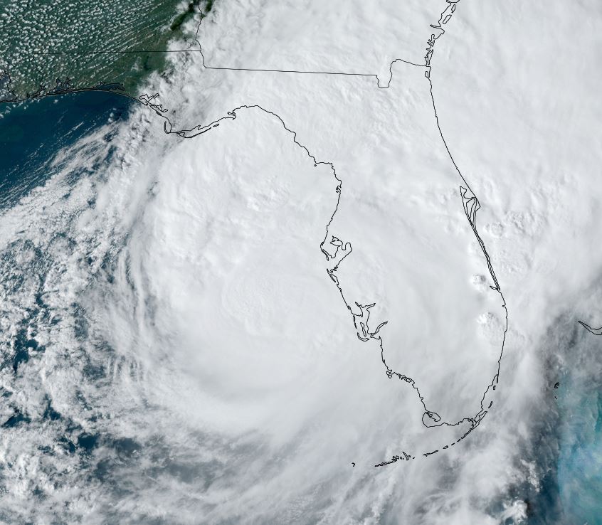
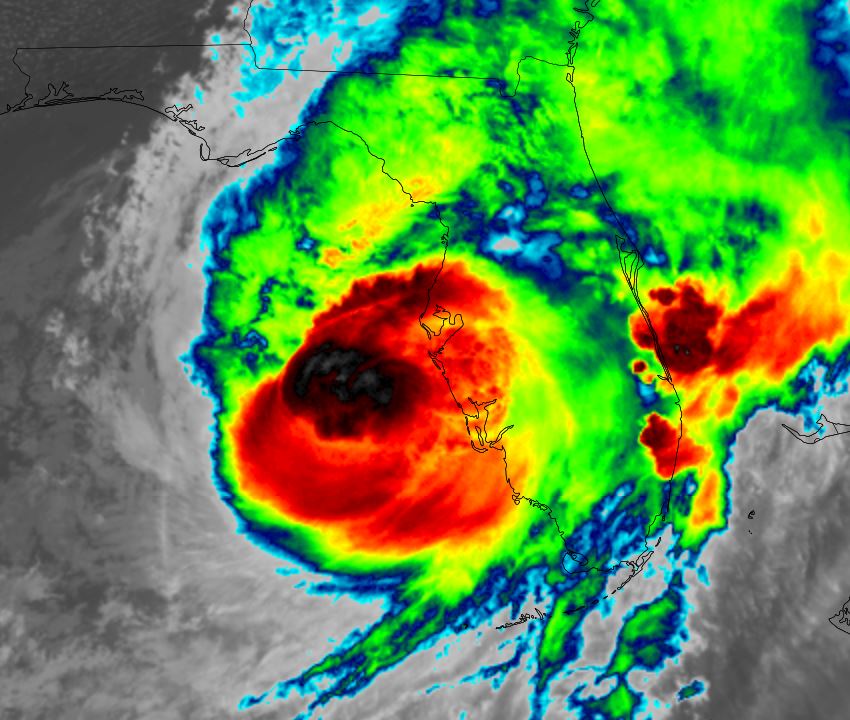
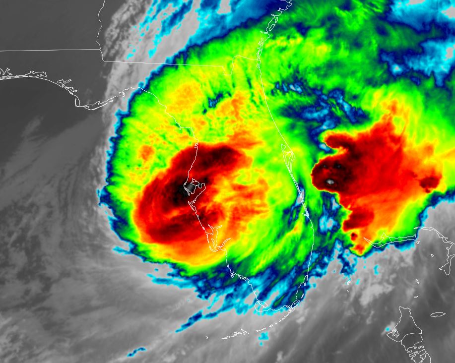
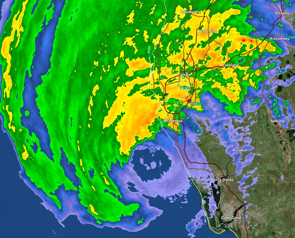
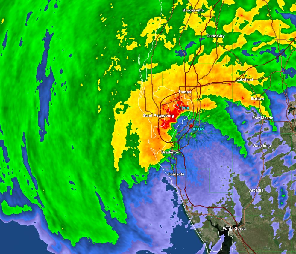
Milton has shifted farther east and will make landfall a bit farther south than projected to near Sarasota. This small shift brings landfall south of Florida's Sun coast. This means Tampa Bay will escape the worst of the surge and that higher surge is projected farther south. Sarasota to Ft Myers will see the highest water increases.

So far highest sustained winds / gusts:
Albert Witted airport 64 / 90 mph
Sarasota / Bradenton intl 58 / 93 mph
Northport 42 / 80 mph
Macdill AFB 46 / 58 mph
Tampa 36 / 64 mph
Punta Gorda 51 / 79 mph
Bay Point Middle School 32 / 72 mph
Clearwater Beach 65 / * mph
St. Pete / Clearwater apt 45 / 81 mph
Brooksville 37 / 64 mph

* = missing

From NHC: A sustained wind of 78 mph (126 km/h) and a gust of 97 mph (156 km/h) was recently reported at a NOAA C-MAN station in Venice. A
sustained wind of 77 mph (124 km/h) and a gust of 100 mph (161 km/h) was recently reported at a WeatherFlow station at Egmont Channel. A
sustained wind of 67 mph (107 km/h) and a gust of 83 mph (133 km/h) was recently reported at a WeatherFlow station at Skyway Fishing
Pier. A sustained wind of 40 mph (64 km/h) and a gust of 73 mph (117 km/h) was recently reported at the Sarasota-Bradenton International
Airport.

The Weather Situation
SUMMARY OF 800 PM EDT...0000 UTC...INFORMATION
----------------------------------------------
LOCATION...27.2N 82.8W
ABOUT 20 MI...30 KM WSW OF SARASOTA FLORIDA
ABOUT 130 MI...205 KM SW OF ORLANDO FLORIDA
MAXIMUM SUSTAINED WINDS...120 MPH...195 KM/H
PRESENT MOVEMENT...ENE OR 60 DEGREES AT 15 MPH...24 KM/H
MINIMUM CENTRAL PRESSURE...954 MB...28.17 INCHES

Tropicast: IR Satellite RAMMB / CIRA Slider Wednesday Evening
Image

Tropicast: GR Level 3 Radar Tampa 6:30 pm Wednesday Evening
Image

Tropicast: GR Level 3 Radar Tampa 7:30 pm Wednesday Evening
Image

Tropicast: GR Level 3 Radar Tampa 8:30 pm Wednesday Evening
Image

Tropical Weather Forecast:
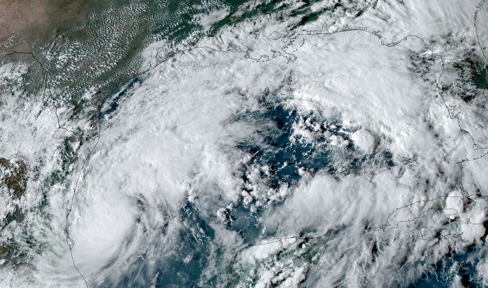
Milton is making landfall near Sarasota soon and will be just south of Orlando later tonight and near Cape Canaveral tomorrow morning. It will be transforming into an extratropical cyclone shortly after moving off of the Florida east coast tomorrow. Keep in mind that surge will also be experienced on the east coast of Florida and northward into the SE US coast.
Rich Johnson
Twitter: https://twitter.com/richjohnsonwx
Certified Broadcast Meteorologist - Hurricane Expert
User avatar
Tropical Inspector
Site Admin
Site Admin
Posts: 3697
Joined: Tue Feb 20, 2007 2:28 pm
Antispam: no
Location: Under a palm tree
Contact:

Re: Milton

Post by Tropical Inspector »

Thursday Early Morning Update
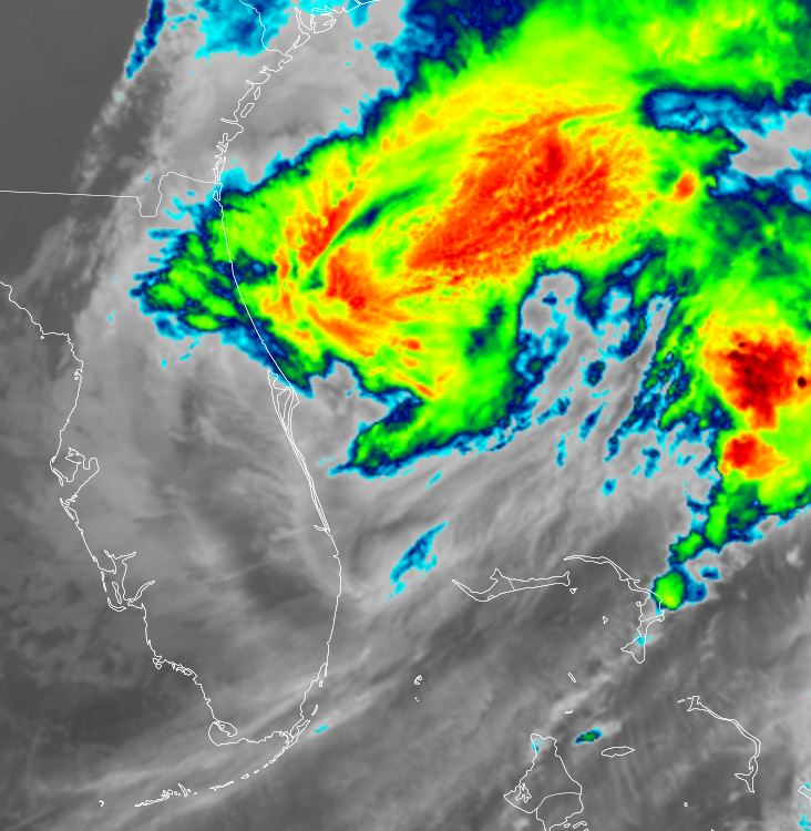
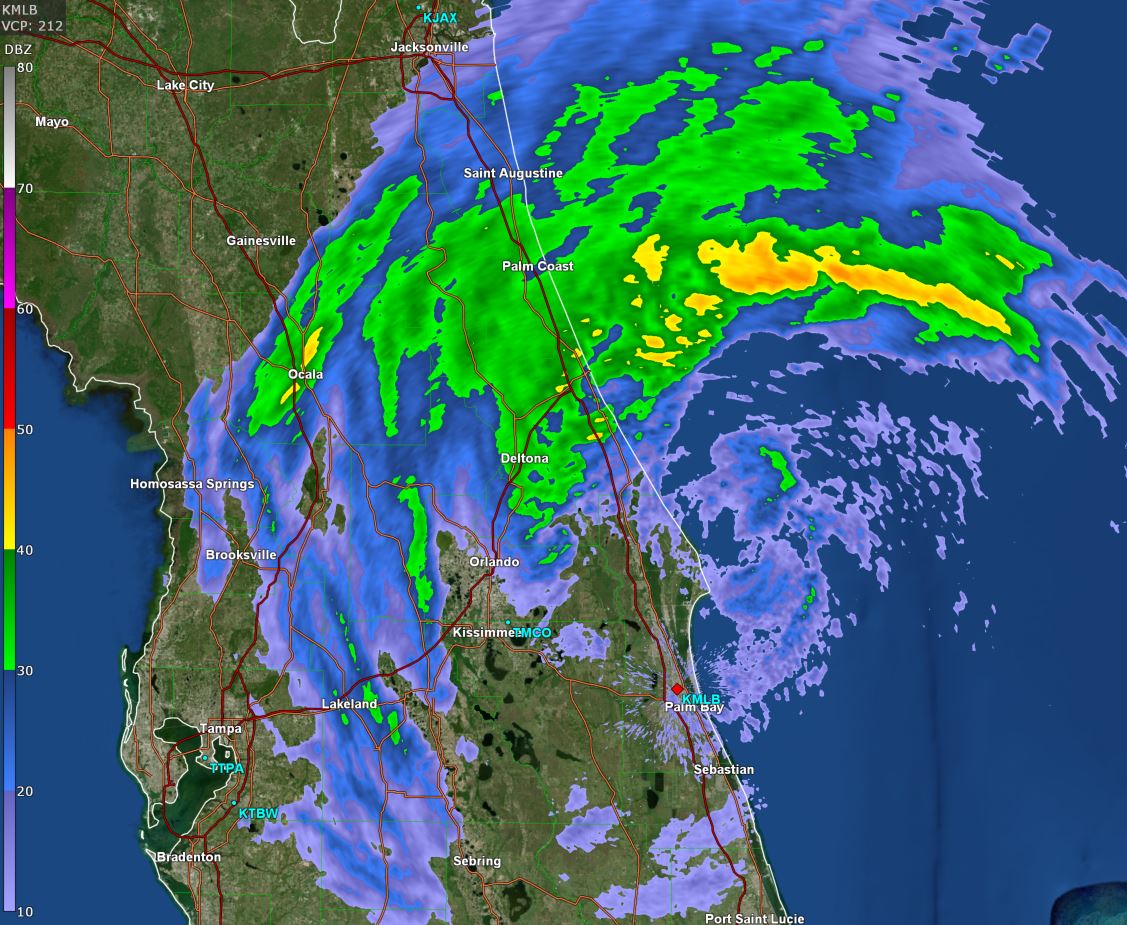
Milton offshore again

Milton has moved off Florida's east coast. It is essentially an extratropical cyclone at this point, but NHC doesn't classify it as one until later this evening.
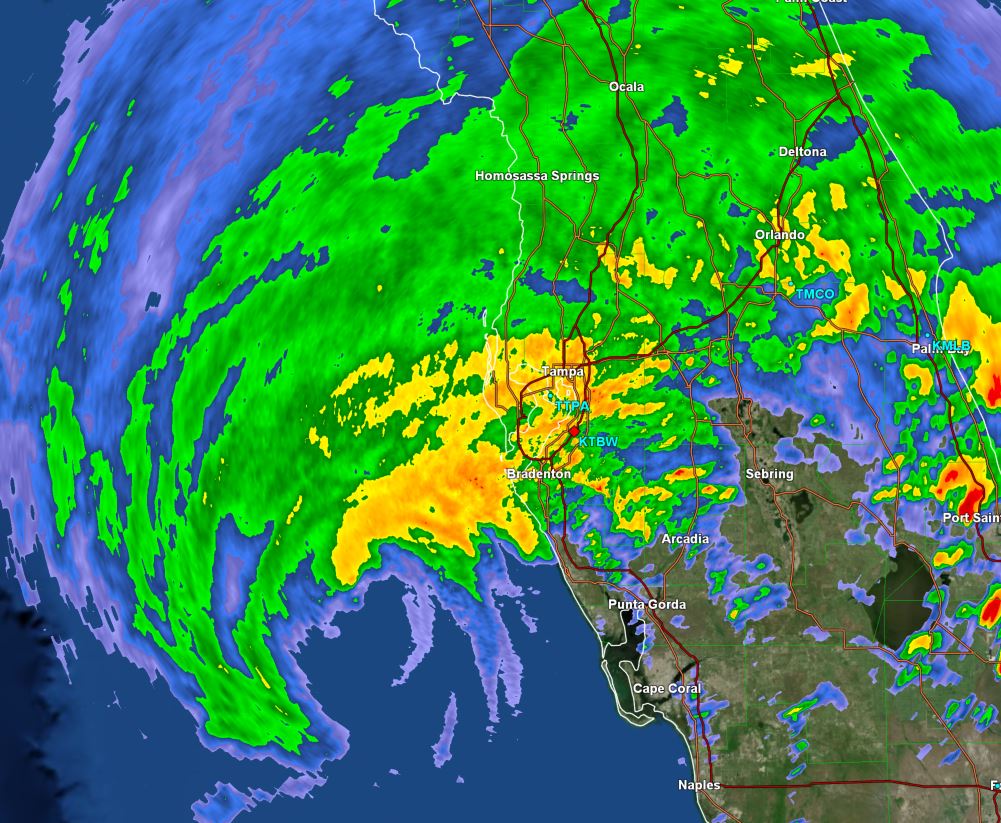
Some winds from overnight and early this morning.... highest sustained winds / gusts:
Orlando / Sanford 52 / 79 mph
Orlando Exective apt 41 / 73 mph
Kissimmee 51 / 63 mph
Tampa 54 / 93 mph
Lakeland 33 / 64 mph
Maitland 41 / 57 mph
Daytona Beach intl 62 / 87 mph
Ponce Inlet 66 / *
Cape Canaveral 55 / 67 mph

* = missing (also note that the sustained and gusts may not have occurred at the same time)

From NHC:
A sustained wind of 75 mph (121 km/h) and a gust to 83 mph (134 km/h) was recently reported at a Weatherstem station in
Marineland. A sustained wind of 61 mph (98 km/h) and a gust to 76 mph (122 km/h) was recently reported at a Weatherstem station on
South Hutchinson Island. A sustained wind of 60 mph (97 km/h) and a gust of 87 mph (140 km/h) was recently reported at Daytona Beach
International Airport.
The Weather Situation
SUMMARY OF 500 AM EDT...0900 UTC...INFORMATION
----------------------------------------------
LOCATION...28.5N 80.5W
ABOUT 10 MI...15 KM NE OF CAPE CANAVERAL FLORIDA
ABOUT 255 MI...410 KM NW OF GREAT ABACO ISLAND
MAXIMUM SUSTAINED WINDS...85 MPH...140 KM/H
PRESENT MOVEMENT...NE OR 55 DEGREES AT 18 MPH...30 KM/H
MINIMUM CENTRAL PRESSURE...976 MB...28.82 INCHES

Tropicast: IR Satellite RAMMB / CIRA Slider Thursday Morning
Image

Tropicast: GR Level 3 Radar Melbourne 4:45am Thursday Morning
Image


Tropical Weather Forecast:
Milton is moving east of Florida and officially will transform into an extratropical cyclone later today as it continues east into the north Atlantic.
Rich Johnson
Twitter: https://twitter.com/richjohnsonwx
Certified Broadcast Meteorologist - Hurricane Expert
Post Reply

Return to “2024 Atlantic Hurricane Updates”

Who is online

Users browsing this forum: No registered users and 3 guests