Debby

Tropical cyclone archives of the 2024 Atlantic hurricane season
Post Reply
User avatar
Tropical Inspector
Site Admin
Site Admin
Posts: 3697
Joined: Tue Feb 20, 2007 2:28 pm
Antispam: no
Location: Under a palm tree
Contact:

Debby

Post by Tropical Inspector »

Saturday Afternoon Update
TD 4 disorganized


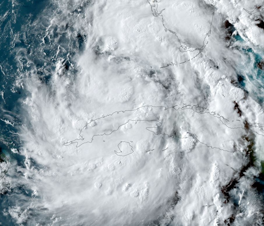
Satellite imagery shows two areas of deep convection. The first is WNW of Key West in the southeastern Gulf of Mexico. The other is south of western Cuba. At this time convection has not been concentrated near the surface low. This is expected later tonight or early Sunday which will allow for strengthening.

The Weather Situation
SUMMARY OF 1100 AM EDT...1500 UTC...INFORMATION
-----------------------------------------------
LOCATION...22.8N 82.0W
ABOUT 40 MI...60 KM SE OF HAVANA CUBA
ABOUT 125 MI...200 KM S OF KEY WEST FLORIDA
MAXIMUM SUSTAINED WINDS...35 MPH...55 KM/H
PRESENT MOVEMENT...WNW OR 300 DEGREES AT 15 MPH...24 KM/H
MINIMUM CENTRAL PRESSURE...1009 MB...29.80 INCHES

Tropicast: Visible Satellite RAAMB Slider
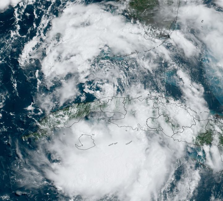
Image

Tropical Weather Forecast:
TD 4 is expected to become a tropical storm and move generally north over the eastern Gulf, making landfall on the Big Bend of Florida by Monday morning. It is expected to then turn more northeast and slowly move over southeastern Georgia and near the coast of South Carolina. Heavy rainfall is the main concern at this time with wind gusts to tropical storm force where squall bands move inland.
Rich Johnson
Twitter: https://twitter.com/richjohnsonwx
Certified Broadcast Meteorologist - Hurricane Expert
User avatar
Tropical Inspector
Site Admin
Site Admin
Posts: 3697
Joined: Tue Feb 20, 2007 2:28 pm
Antispam: no
Location: Under a palm tree
Contact:

Debby

Post by Tropical Inspector »

Saturday Evening Update
Debby in the SE Gulf of Mexico

Current visible satellite imagery shows that convection is now near the center of the circulation and extending outward. Some slight banding also is visible. Additional organization is expected overnight. A recent Hurricane Hunter aircraft show winds remain near minimal tropical storm strength.

The Weather Situation
SUMMARY OF 800 PM EDT...0000 UTC...INFORMATION
----------------------------------------------
LOCATION...24.1N 83.3W
ABOUT 100 MI...160 KM WSW OF KEY WEST FLORIDA
ABOUT 270 MI...435 KM S OF TAMPA FLORIDA
MAXIMUM SUSTAINED WINDS...40 MPH...65 KM/H
PRESENT MOVEMENT...NW OR 315 DEGREES AT 14 MPH...22 KM/H
MINIMUM CENTRAL PRESSURE...1005 MB...29.68 INCHES

Tropicast: Visible Satellite RAAMB Slider
Image

Tropical Weather Forecast:
The most recent weather models show a slight westward shift. This would allow for two things to happen. 1. It would move the stronger wind gusts farther away from Florida's west (Sun) coast and 2. give it more time to strengthen. With this happening, NHC now makes Debby a minimal hurricane upon landfall near Apalachee Bay, FL around midday Monday. It will then slow and continue more northeasterly over southeast Georgia / eastern South Carolina.

The main effects over the Big Bend of Florida will be storm surge, heavy rainfall, and damaging winds. Georgia and South Carolina will have heavy rainfall with the possibily of flooding. Some wind damage is also possible over southern Georgia.

With any landfall tropical cyclone there is the potential for isolated tornadoes. :idea: Complete any preparations by Sunday afternoon before the onset of tropical storm force wind gusts arrive.
Rich Johnson
Twitter: https://twitter.com/richjohnsonwx
Certified Broadcast Meteorologist - Hurricane Expert
User avatar
Tropical Inspector
Site Admin
Site Admin
Posts: 3697
Joined: Tue Feb 20, 2007 2:28 pm
Antispam: no
Location: Under a palm tree
Contact:

Re: Debby

Post by Tropical Inspector »

Sunday Morning Update
Debby shows some strengthening overnight

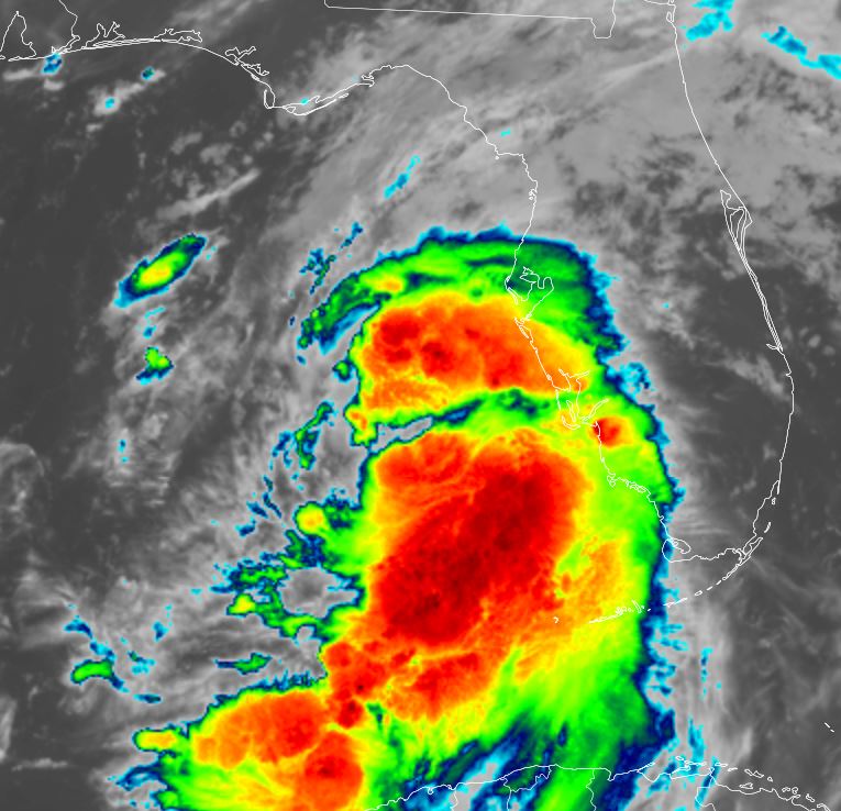
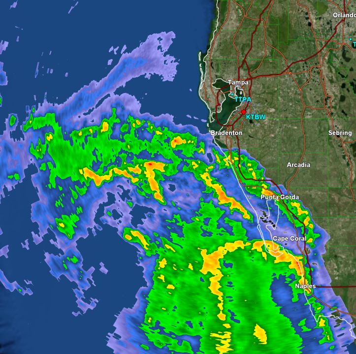
IR satellite imagery shows very heavy rainfall west of the Florida coast west of Ft Myers this morning. Some strengthening occurred overnight, and this trend is expected to continue on Sunday

The Weather Situation
SUMMARY OF 800 AM EDT...1200 UTC...INFORMATION
----------------------------------------------
LOCATION...26.3N 84.2W
ABOUT 155 MI...255 KM SW OF TAMPA FLORIDA
ABOUT 205 MI...330 KM SSW OF CEDAR KEY FLORIDA
MAXIMUM SUSTAINED WINDS...60 MPH...95 KM/H
PRESENT MOVEMENT...NNW OR 330 DEGREES AT 13 MPH...20 KM/H
MINIMUM CENTRAL PRESSURE...1001 MB...29.56 INCHES

Tropicast: IR Satellite RAAMB CIRA Slider
Image

Tropicast: Florida Radar 7:50 am edt (GR Level 3)
Image

Tropical Weather Forecast:
Debby is still expected to reach hurricane strength before making landfall near Apalachee Bay Monday morning / midday. Winds aloft will weaken upon landfall and Debby posses a serious flooding risk over south Georgia and eastern South Carolina.

The main effects over the Big Bend of Florida will be storm surge, flooding from heavy rainfall, and damaging winds. South Georgia and eastern South Carolina will have heavy rainfall with a serious flooding risk. Some wind damage is also possible over southern Georgia.

With any landfall tropical cyclone there is the potential for isolated tornadoes. :idea: Complete any preparations by Sunday afternoon before the onset of tropical storm force wind gusts arrive.
Rich Johnson
Twitter: https://twitter.com/richjohnsonwx
Certified Broadcast Meteorologist - Hurricane Expert
User avatar
Tropical Inspector
Site Admin
Site Admin
Posts: 3697
Joined: Tue Feb 20, 2007 2:28 pm
Antispam: no
Location: Under a palm tree
Contact:

Re: Debby

Post by Tropical Inspector »

Sunday Afternoon Update
Debby continues to slowly strengthen

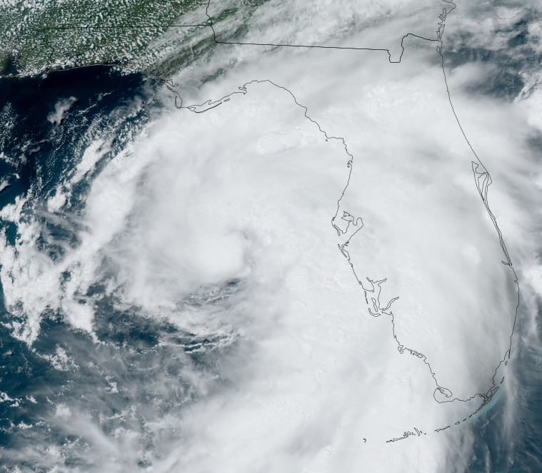
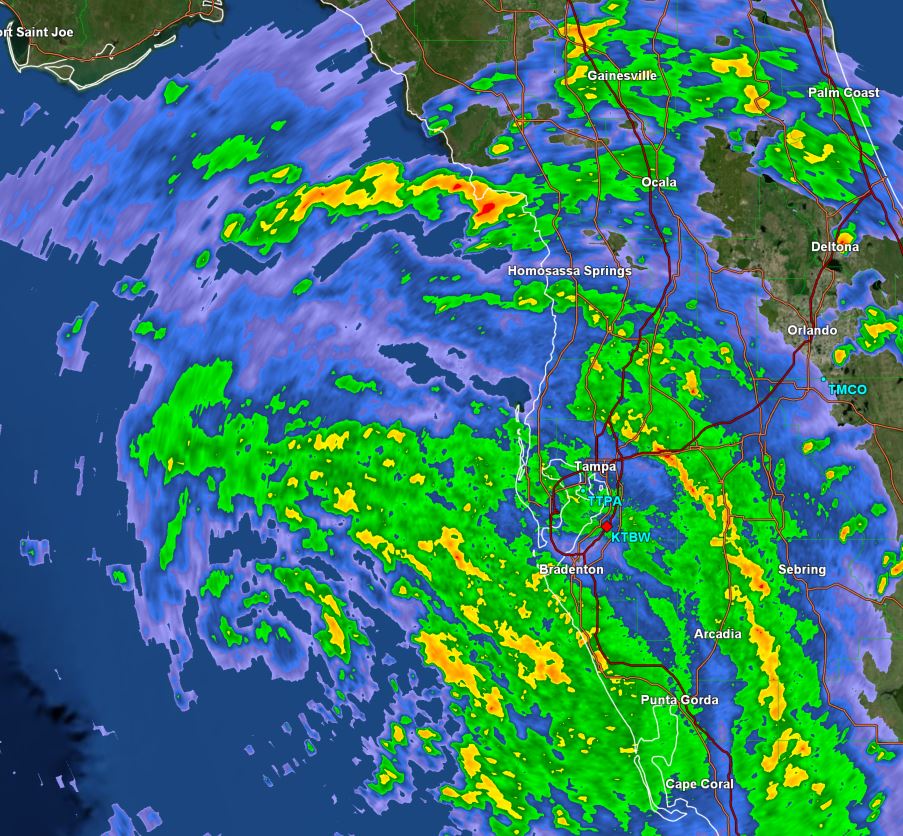
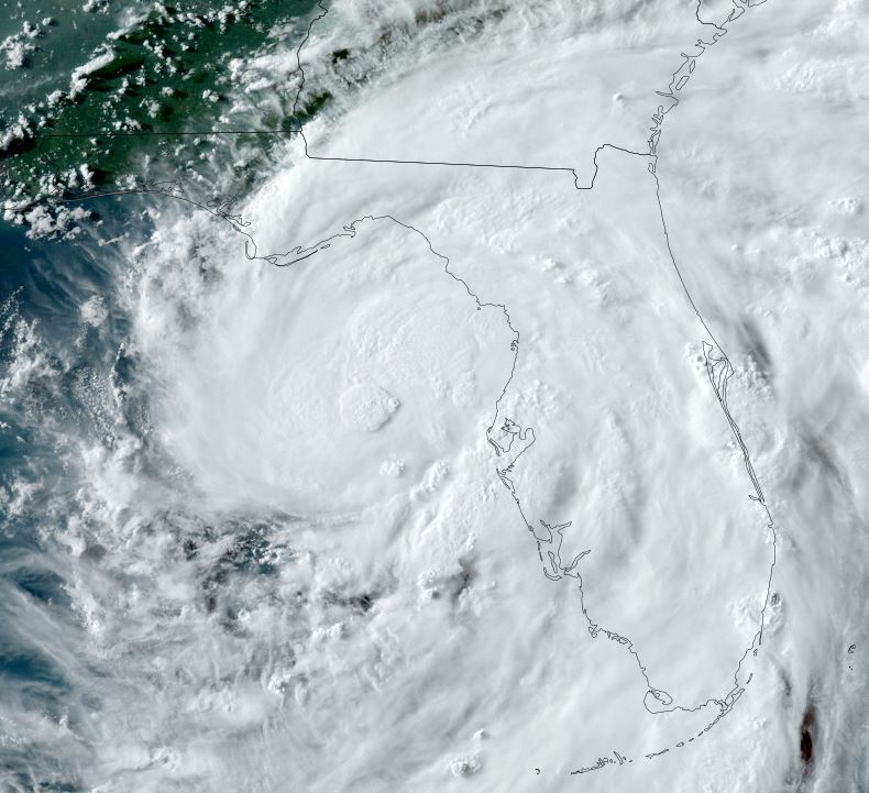
Satellite imagery shows the deepest convection remaining on the eastern side of Debby's circulation. Doppler radar estimates indicate that more than four inches of rain has fallen over portions of the western Florida peninsula. The western side of the circulation, including the panhandle of Florida remains dry, except for isolated showers.

Hurricane Hunter aircraft data show that pressure continues to drop and winds slowly increasing. More rapid strengthening is possible as the structure becomes better defined.

The Weather Situation
SUMMARY OF 200 PM EDT...1800 UTC...INFORMATION
----------------------------------------------
LOCATION...27.3N 84.4W
ABOUT 125 MI...205 KM WSW OF TAMPA FLORIDA
ABOUT 145 MI...235 KM SSW OF CEDAR KEY FLORIDA
MAXIMUM SUSTAINED WINDS...65 MPH...100 KM/H
PRESENT MOVEMENT...NNW OR 330 DEGREES AT 13 MPH...20 KM/H
MINIMUM CENTRAL PRESSURE...992 MB...29.30 INCHES

Tropicast: Visible Satellite RAAMB CIRA Slider
Image

Tropicast: Florida Radar 2:45 pm edt (GR Level 3)
Image

Tropical Weather Forecast:
Debby is still expected to reach hurricane strength before making landfall near Apalachee Bay Monday morning / midday. Winds aloft will weaken upon landfall and Debby posses a serious flooding risk over south Georgia and eastern South Carolina. At this time Debby is expected to make landfall as a category 1 hurricane, but may be a bit stronger if more rapid deepening occurs overnight.

The effects over the Big Bend of Florida will be storm surge, flooding from heavy rainfall, and damaging winds. South Georgia and eastern South Carolina will have heavy rainfall with a serious flooding risk. Some wind damage is also possible over southern Georgia.

With any landfall tropical cyclone there is the potential for isolated tornadoes. :idea: Complete any preparations today before the onset of tropical storm force wind gusts arrive.
Rich Johnson
Twitter: https://twitter.com/richjohnsonwx
Certified Broadcast Meteorologist - Hurricane Expert
User avatar
Tropical Inspector
Site Admin
Site Admin
Posts: 3697
Joined: Tue Feb 20, 2007 2:28 pm
Antispam: no
Location: Under a palm tree
Contact:

Re: Debby

Post by Tropical Inspector »

Sunday Evening Update
Debby almost a hurricane

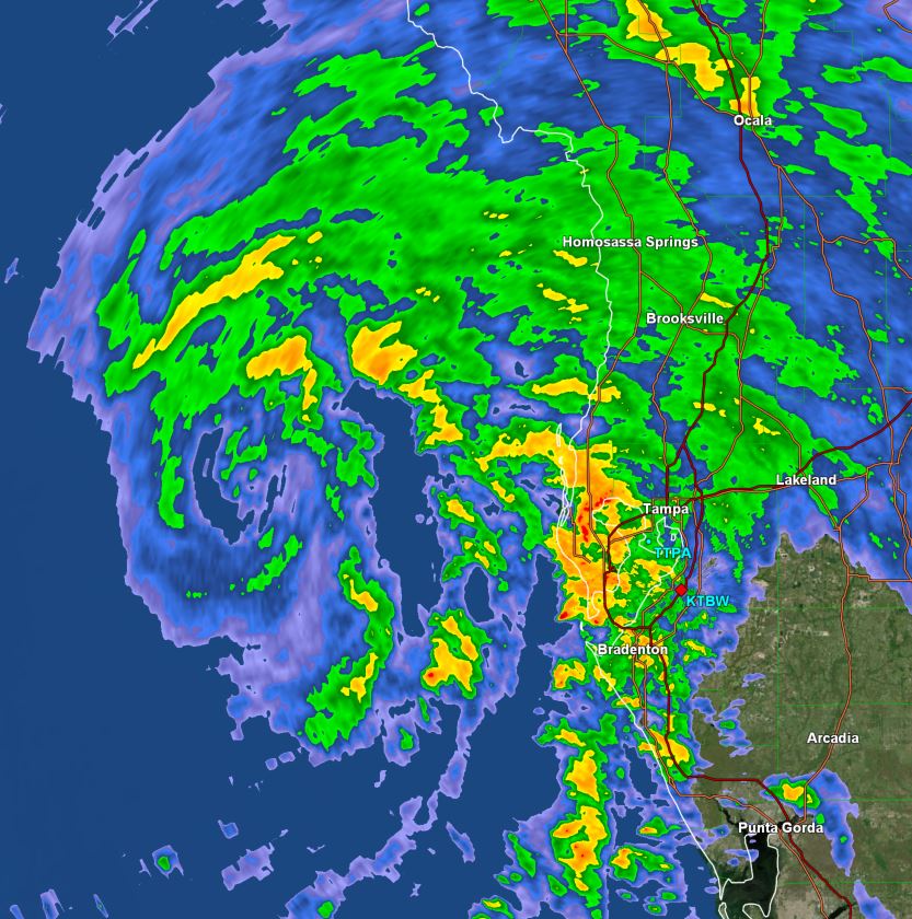
Radar has estimated amounts of 2-4" with isolated totals over 7" along the western peninsula of Florida. Isolated wind gusts to tropical storm force are associated with these bands moving in from the Gulf. Satellite imagery also shows deep convection around the center of circulation as an eyewall forms. Debby is expected to reach minimal hurricane strength later this evening.

The Weather Situation
SUMMARY OF 800 PM EDT...0000 UTC...INFORMATION
----------------------------------------------
LOCATION...28.1N 84.1W
ABOUT 100 MI...160 KM W OF TAMPA FLORIDA
ABOUT 90 MI...150 KM SW OF CEDAR KEY FLORIDA
MAXIMUM SUSTAINED WINDS...70 MPH...110 KM/H
PRESENT MOVEMENT...N OR 360 DEGREES AT 12 MPH...19 KM/H
MINIMUM CENTRAL PRESSURE...992 MB...29.30 INCHES

Tropicast: Visible Satellite RAAMB CIRA Slider
Image

Tropicast: Florida Radar 8:25 pm edt (GR Level 3)
Image

Tropical Weather Forecast:
Debby is still expected to reach hurricane strength before making landfall near Apalachee Bay Monday morning / midday. Winds aloft will weaken upon landfall and Debby posses a serious flooding risk over south Georgia and eastern South Carolina. At this time Debby is expected to make landfall as a category 1 hurricane, but may be a bit stronger if more rapid deepening occurs overnight.

The effects over the Big Bend of Florida will be storm surge, flooding from heavy rainfall, and damaging winds. South Georgia and eastern South Carolina will have heavy rainfall with a serious flooding risk. Some wind damage is also possible over southern Georgia.

With any landfall tropical cyclone there is the potential for isolated tornadoes. :idea:
Rich Johnson
Twitter: https://twitter.com/richjohnsonwx
Certified Broadcast Meteorologist - Hurricane Expert
User avatar
Tropical Inspector
Site Admin
Site Admin
Posts: 3697
Joined: Tue Feb 20, 2007 2:28 pm
Antispam: no
Location: Under a palm tree
Contact:

Re: Debby

Post by Tropical Inspector »

Monday Morning Update
Debby making landfall soon

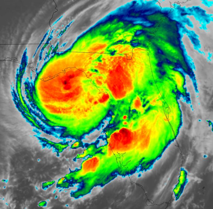
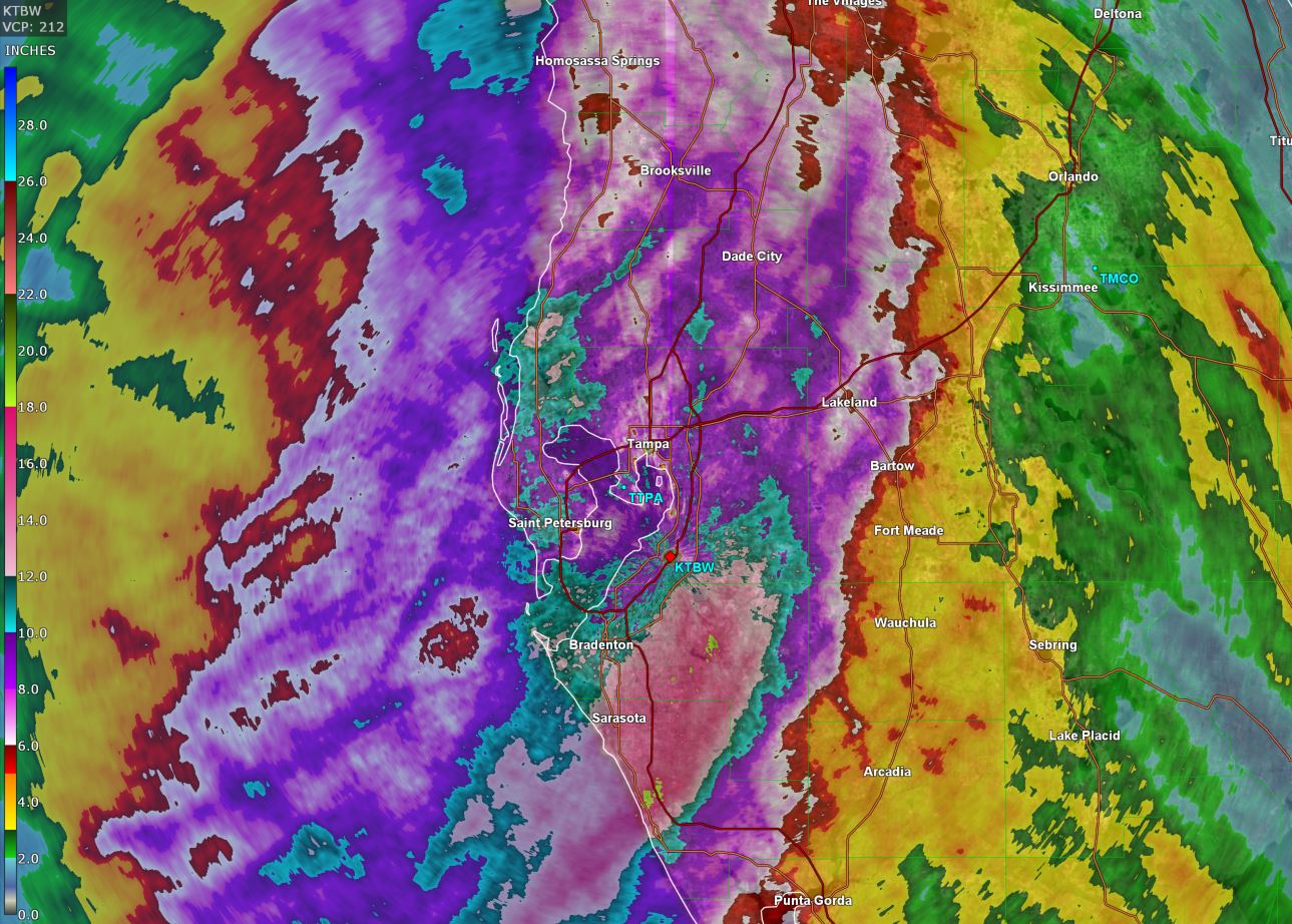
Radar imagery shows that Debby is close to making landfall on Florida's Big Bend coast as a minimal hurricane. Rainfall estimates of widespread totals over 5-7" are noted over the western Florida peninsula. A few non-official stations reported about 12" near New Port Richey.

A Hurricane Hunter aircraft is currently investigating and so far has found winds to 66 kts with a SFMR reading of 64 kts. Buoy data since last evening has shown top wave heights up to 15 feet offshore and top winds to about 52 kts. This does not reflect hurricane strength, but it's likely that the strongest winds did not intercept the buoys. Unfortunately, a station at Keaton Beach has been out of service since November of last year and is nearly at the point of landfall. This buoy would have given very valuable data. NHC reported that "the strongest so far is in Horseshoe Beach, where a weatherstation recently recorded a sustained wind of 57 kt and a gust to 83 kt".

The Weather Situation
SUMMARY OF 500 AM EDT...0900 UTC...INFORMATION
----------------------------------------------
LOCATION...29.5N 83.7W
ABOUT 45 MI...75 KM NW OF CEDAR KEY FLORIDA
ABOUT 70 MI...115 KM SSE OF TALLAHASSEE FLORIDA
MAXIMUM SUSTAINED WINDS...80 MPH...130 KM/H
PRESENT MOVEMENT...NNE OR 15 DEGREES AT 10 MPH...17 KM/H
MINIMUM CENTRAL PRESSURE...979 MB...28.91 INCHES

Tropicast: IR Satellite RAAMB CIRA Slider
Image

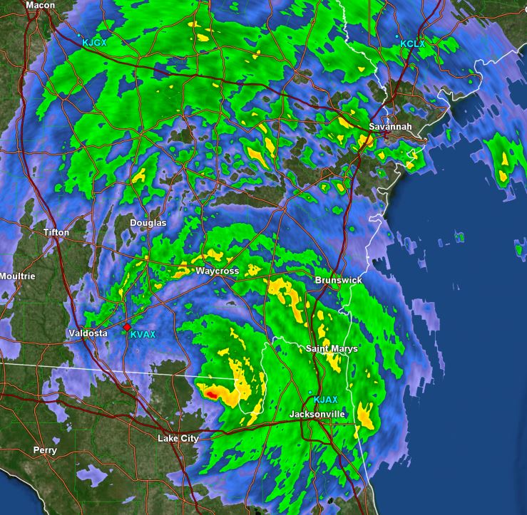
Tropicast: Southesat Georgia Radar 4:52 am edt (GR Level 3)
Image

Tropicast: Florida Tampa Radar 4:52 am edt (GR Level 3)
Image

Tropicast: Florida Rainfall Estimates (GR Level 3)
Image


Tropical Weather Forecast:
Debby is predicted to slowly move across south Georgia and eastern South Carolina the next several days. This will lead to very heavy rainfall totals of 1-2 feet or possibly more. This heavy rainfall will cause a very serious flooding risk.
Rich Johnson
Twitter: https://twitter.com/richjohnsonwx
Certified Broadcast Meteorologist - Hurricane Expert
User avatar
Tropical Inspector
Site Admin
Site Admin
Posts: 3697
Joined: Tue Feb 20, 2007 2:28 pm
Antispam: no
Location: Under a palm tree
Contact:

Re: Debby

Post by Tropical Inspector »

Monday Evening Update
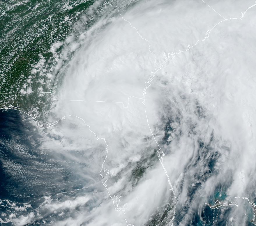
Debby moving into SE Georgia

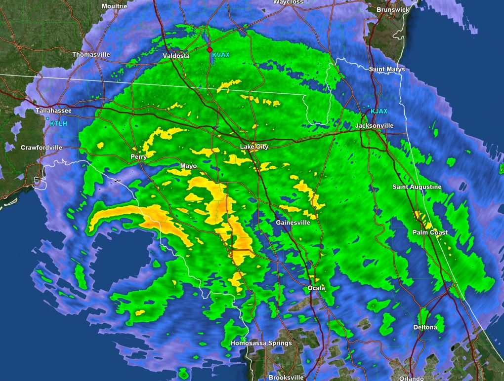
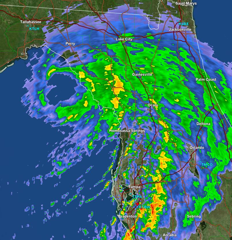
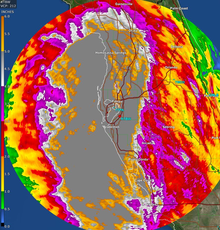
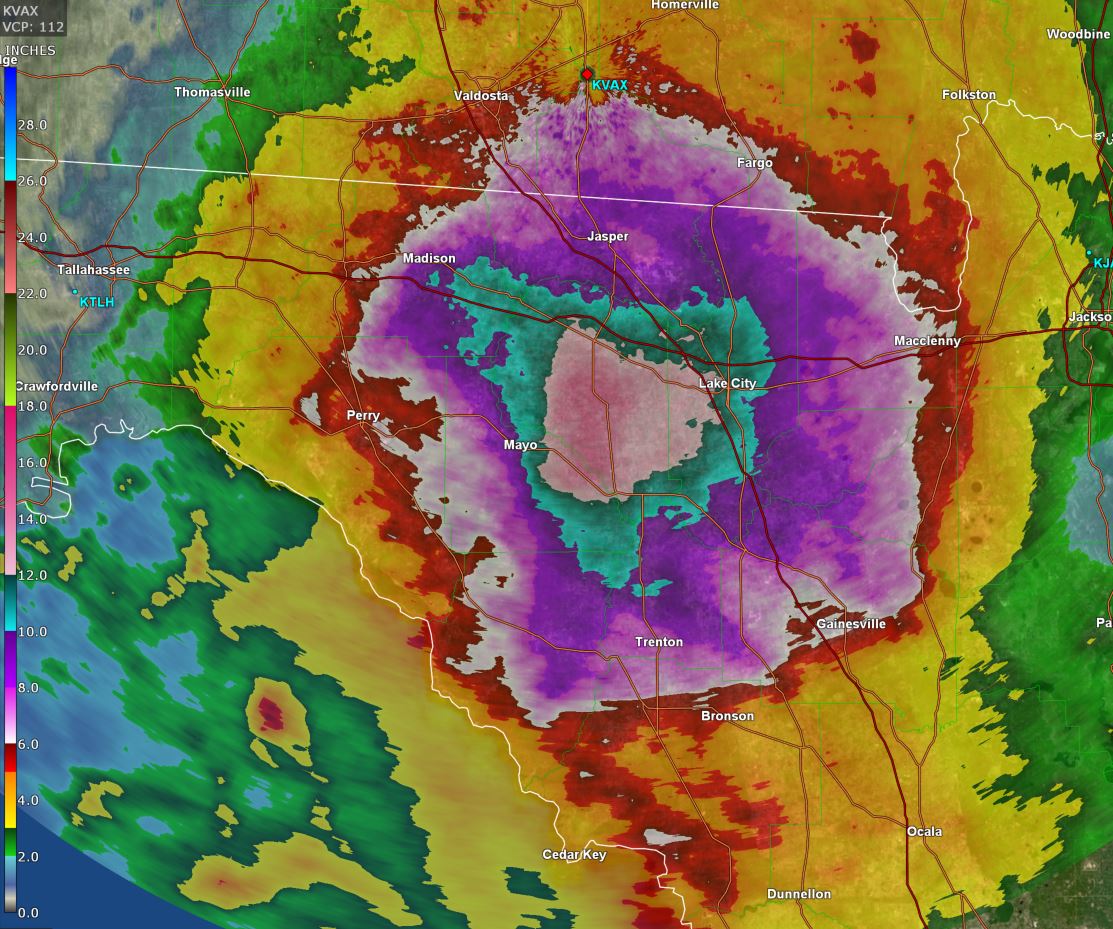
Rainfall totals have been estimated to around 12 or more inches over portions of the western Florida peninsula into the Big Bend area of north Florida. Totals have ranged from 2 to nearly 6 inches over SE Georgia as Debby is now moving into the area. Very heavy rainfall will spread into eastern South Carolina during the next few days.

The Weather Situation
SUMMARY OF 500 PM EDT...2100 UTC...INFORMATION
----------------------------------------------
LOCATION...30.5N 82.9W
ABOUT 30 MI...50 KM SE OF VALDOSTA GEORGIA
MAXIMUM SUSTAINED WINDS...50 MPH...85 KM/H
PRESENT MOVEMENT...NE OR 35 DEGREES AT 6 MPH...9 KM/H
MINIMUM CENTRAL PRESSURE...994 MB...29.36 INCHES

Tropicast: Visible Satellite RAAMB CIRA Slider
Image

Tropicast: Southeast Georgia Radar 5:45 pm edt (GR Level 3)
Image

Tropicast: North Florida / South Georgia Rainfall Estimates (GR Level 3)
Image

Tropicast: Florida Peninsula Rainfall Estimates (GR Level 3)
Image


Tropical Weather Forecast:
Debby is predicted to slowly move across south Georgia and eastern South Carolina the next several days. This will lead to very heavy rainfall totals of 1-2 feet or possibly more. This heavy rainfall will cause a very serious flooding risk.
Rich Johnson
Twitter: https://twitter.com/richjohnsonwx
Certified Broadcast Meteorologist - Hurricane Expert
User avatar
Tropical Inspector
Site Admin
Site Admin
Posts: 3697
Joined: Tue Feb 20, 2007 2:28 pm
Antispam: no
Location: Under a palm tree
Contact:

Re: Debby

Post by Tropical Inspector »

Tuesday Morning Update
Debby heading offshore again

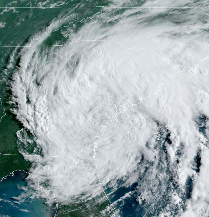
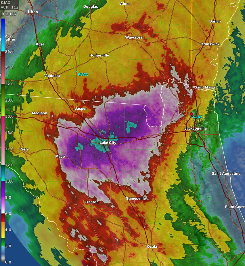
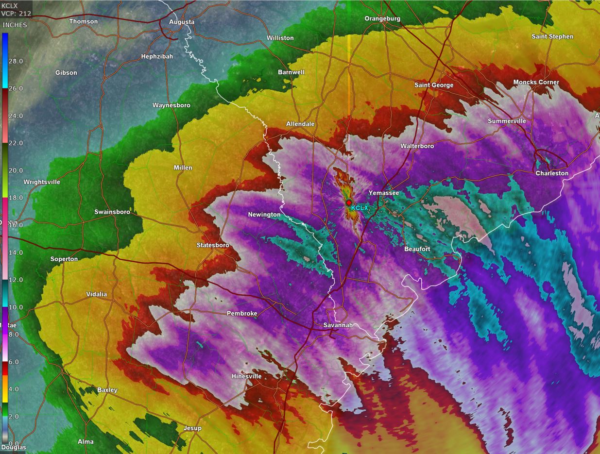
Debby is moving back out to sea off of the Georgia coast. Heavy rainfall continues, especially over eastern South Carolina - although not as torrential as yesterday's rain in Florida. Rainfall amounts have exceeded 12" over parts of Florida, SE Georgia and eastern South Carolina. Flooding rainfall remains a high threat.

The Weather Situation
SUMMARY OF 800 AM EDT...1200 UTC...INFORMATION
----------------------------------------------
LOCATION...31.9N 81.3W
ABOUT 20 MI...35 KM SW OF SAVANNAH GEORGIA
ABOUT 105 MI...165 KM SW OF CHARLESTON SOUTH CAROLINA
MAXIMUM SUSTAINED WINDS...45 MPH...75 KM/H
PRESENT MOVEMENT...NE OR 50 DEGREES AT 6 MPH...9 KM/H
MINIMUM CENTRAL PRESSURE...999 MB...29.50 INCHES

Tropicast: Visible Satellite RAAMB CIRA Slider
Image

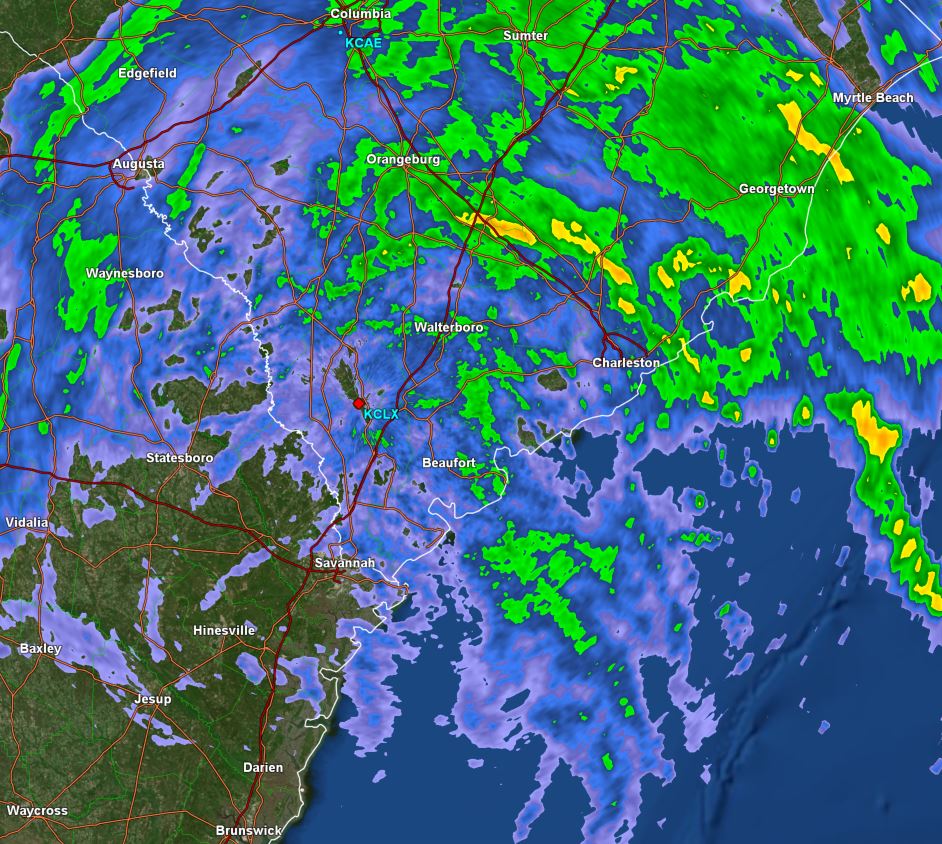
Tropicast: Charleston, SC Radar 9:30 am edt (GR Level 3)
Image

Tropicast: NE Florida Rainfall Estimates (GR Level 3)
Image

Tropicast: Eastern South Carolina / SE Georgia Rainfall Estimates (GR Level 3)
Image


Tropical Weather Forecast:
Debby will move offshore of the Georgia coast then move back inland into South Carolina and slowly turn north over the next 3-4 days. Very heavy rainfall continues to be a very serious flooding risk.
Rich Johnson
Twitter: https://twitter.com/richjohnsonwx
Certified Broadcast Meteorologist - Hurricane Expert
User avatar
Tropical Inspector
Site Admin
Site Admin
Posts: 3697
Joined: Tue Feb 20, 2007 2:28 pm
Antispam: no
Location: Under a palm tree
Contact:

Re: Debby

Post by Tropical Inspector »

Wednesday Morning Update
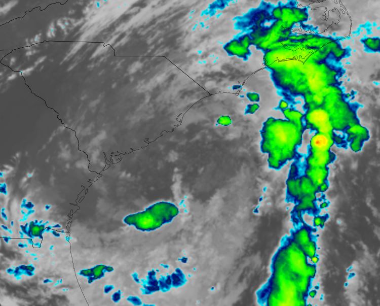
Debby offshore of South Carolina

Debby remains a minimal tropical storm this morning. The main threat remains from flooding rainfall from South Carolina northward into Virginia. Currently rainbands are only scattered, but will strengthen with daytime heating.

The Weather Situation
SUMMARY OF 500 AM EDT...0900 UTC...INFORMATION
----------------------------------------------
LOCATION...31.9N 79.5W
ABOUT 65 MI...105 KM SSE OF CHARLESTON SOUTH CAROLINA
ABOUT 90 MI...145 KM E OF SAVANNAH GEORGIA
MAXIMUM SUSTAINED WINDS...45 MPH...75 KM/H
PRESENT MOVEMENT...E OR 85 DEGREES AT 5 MPH...7 KM/H
MINIMUM CENTRAL PRESSURE...995 MB...29.39 INCHES

Tropicast: IR Satellite RAAMB CIRA Slider
Image

Tropical Weather Forecast:
Debby will move inland into South Carolina and be absorbed by an approaching cold front over the next few days.
Rich Johnson
Twitter: https://twitter.com/richjohnsonwx
Certified Broadcast Meteorologist - Hurricane Expert
Post Reply

Return to “2024 Atlantic Hurricane Updates”

Who is online

Users browsing this forum: No registered users and 3 guests