|
|
Hurricane Katrina Facts
Facts about Hurricane Katrina
Hurricane Katrina was the costliest U.S. hurricane on record and one of the worst natural disasters in U. S. history. Hurricane Katrina will be remembered for its catastrophic flooding in New Orleans due to levee failure. Katrina formed in the central Bahamas and moved northwest. It made landfall in south Florida on the Broward/Miami-Dade counties line as a category 1 hurricane. Virginia Key reported a gust to 93 mph. Heavy rain also fell. Key West had 10.05" and Homested 14.04".
As Hurricane Katrina moved over the Gulf of Mexico, it turned north and strengthened into a category 5 hurricane with top sustained winds of 175 mph. Katrina was large in size and gererated a large wind field. This created huge waves in the Gulf Of Mexico where a buoy 74 miles south of Dauphin Island, AL measured a peak significant wave height of 55 feet. Katrina ingested some dry air and weakened into a category 3 hurricane as it made landfall near Buras, LA. It briefly passed over the Gulf of Mexico waters again and made its last landfall on the Mississippi - Louisiana border. In Louisiana, a storm surge of 11.8 feet was measured at New Orleans Lakefront airport. New Orleans International airport had a peak gust to 98 mph. New Orlean's wind damage was comparable only to a category 1 or 2 hurricane. The majority of the damage in New Orleans was due to levee failure.
Up to 80% of the city of New Orleans was flooded with up to 20 feet of water. The Mississippi coast suffered catastrophic damage due to storm surge and wind damage. A surge of 24-28 feet was measured along the Mississippi coast with the highest near Pass Christian at 27.8 feet. The storm surge went inland for about six miles, but up to twelve miles along the rivers. Pearl River EOC at Poplarville recorded a wind gust to 135 mph. In all, total damage estimates were placed near $108 billion.
Where did Hurricane Katrina originate?
Hurricane Katrina originated in the southern Bahamas. Hurricane Katrina originated from a combination of a mid-level low from tropical depression 10 and a tropical wave. Tropical depression 10 weakened over 800 miles east of the Lesser Antillies as winds aloft were hostile for development. The low level circulation continued westward and continuted to weaken, as the mid-level circulation separted and moved farther north of the Leeward Islands. Another tropical wave lagging behind tropical depression ten, caught up to the mid-level circulation which caused an increase in unsettled weather north of Puerto Rico. Wind shear decreased and Katrina formed into a tropical depression in the southeastern Bahamas on the afternoon of August 23.
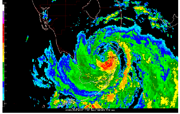
Hurricane Katrina Radar Picture
Hurricane Katrina Facts Summary
- Lowest pressure: 902 millibars / 26.64 inches
- Sixth strongest hurricane ever measured by pressure in the Atlantic basin.
- Costliest hurricane in U.S. history
- U.S. Damage: $125 billion - unadjusted dollars
- U.S. Damage: $160 billion - adjusted dollars for 2017
- Third strongest hurricane ever to make a U.S. landfall measured by pressure (920mb).
- Pressure and sustained wind at landfall: (Broward/Miami-Dade county line) 984 millibars / 80 mph
- Pressure and sustained wind at landfall: (Buras, LA) 920 millibars / 125 mph
- Pressure and sustained wind at landfall: (LA-MS border) 928 millibars / 120 mph
- Maximum sustained winds at peak: 175 mph
- Fatalities: 1200
- Storm surge height: 27.8 feet, Pass Christian, MS
- Up to 80% of New Orleans was under water from flooding.
- Hurricane Katrina began as a tropical depression near the southeastern Bahamas
- Hurricane Katrina weakened and became extratropical in the Ohio Valley.
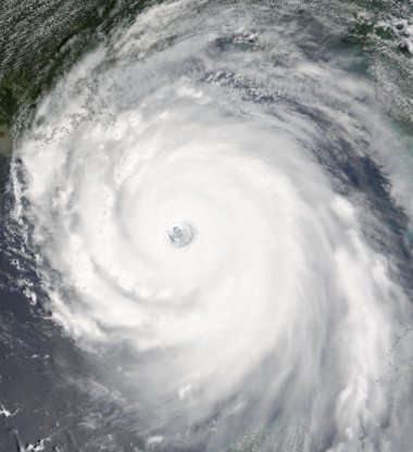
Hurricane Katrina Satellite Picture
Images / data courtesy of the National Hurricane Center / NOAA / NASA
Do you want to find out more about Hurricane Katrina or other hurricanes? Check out our 2005 hurricane summaries.
Back to more hurricane articles.
|
|
|