|
|
Hurricane Andrew Facts
Hurricane Andrew was a Cape Verde hurricane that formed from a tropical wave that moved off of the west coast of Africa on August 14, 1992. It moved west south of the Cape Verde Islands and began to take on banding. By August 16, sufficient orgainization had occured to upgrade the tropical wave to a tropical depresssion. Wind shear aloft lessened and tropical storm Andrew formed on August 17. A strong upper trough to the east southeast of Bermuda allowed tropical storm Andrew to take more of a northwesterly course and miss the Caribbean Islands. Wind shear also did not allow significant strengthening at this time.
Shortly after this time the upper level low weakened and split. One of the upper lows positioned itself southwest of Andrew. Instead of creating wind shear which nearly destroyed the storm, winds aloft now enhanced the outflow. This allowed tropical storm Andrew to strengthen quickly. At the same time, a strong high built over the Southeeastern U.S. setting up a strong easterly flow over Andrew. This flow would steer Andrew directly toward south Florida over the next 2 1/2 days. Hurricane Andrew formed on the morning of August 22. By late on August 23 hurricane Andrew was a caregory 4 hurricane that passed over northern Eleuthera Island in the eastern Bahamas. Andrew weakened some to a pressure of 941 mb over the western part of the Great Bahama Bank. Hurricane Andrew next underwent another rapid deepening phase as it crossed the Florida Straits into south Florida near Homestead. Hurricane Andrew caused great damage to south Florida, especially south of Miami. Andrew weakened as it moved over the Everglades.
After spending only a few hours over south Florida, Hurricane Andrew restrengthened in the Gulf of Mexico, turned north and made a second landfall in Louisiana as a category 3.
Hurricane Andrew was the 3rd category 5 hurricane to hit the U.S. on record. Originally it was classified as a strong category 4 hurricane. After additional evaluations and research
it was upgraded to a category 5. It caused catastrophic damage to south Florida near Homestead. Hurricane Andrew at the time was the costliest hurricane on record with 26.5 billion dollars in damage. Andrew also had the fourth lowest pressure of any U.S. hurricane at landfall at 922 millibars. Only Hurricane Camille, Hurricane Katrina, and the Labor Day hurricane had lower pressures at landfall. As for winds, a Hurricane Hunter aircraft measured a 10,000 foot flight level wind of 196 mph just before landfall in south Florida.
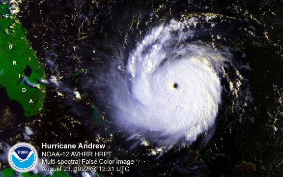
Hurricane Andrew Satellite Picture
Images courtesty of NOAA / NASA
Hurricane Andrew Facts Summary
- Lowest pressure: 922 millibars / 27.23 inches
- Lowest pressure at landfall: 922 millibars / 27.23 inches - 4th lowest of a U.S. land falling hurricane
- Pressure and sustained wind at landfall, Florida: 922 millibars / 175 mph
- Maximum sustained winds at peak: 175 mph
- Fatalities: 26 total, 23 mainland U.S.
- Rainfall Florida: 6.9 inches southeast Florida
- Rainfall Louisiana: Hammond 11.9 inches
- U.S. Damage: $27 billion
- U.S. Damage: $47.79 billion - adjusted dollars for 2017
- Maximum storm tide height Florida: 16.9 feet, Biscayne Bay
- Maximum storm tide height Louisiana: about 8 feet, Lake Borgne to Vermillion Bay
- Maximum storm tide height Bahamas: 23 feet, The Current, Eleuthera
Data courtesy of the National Hurricane Center
Do you want to find out more about Hurricane Andrew or other hurricanes? Check out our 1990-1999 hurricane summaries.
Back to more hurricane articles.
|
|
|