Helene

Tropical cyclone archives of the 2024 Atlantic hurricane season
Post Reply
User avatar
Tropical Inspector
Site Admin
Site Admin
Posts: 3697
Joined: Tue Feb 20, 2007 2:28 pm
Antispam: no
Location: Under a palm tree
Contact:

Helene

Post by Tropical Inspector »

Monday Evening Update
PTC 9 in western Caribbean

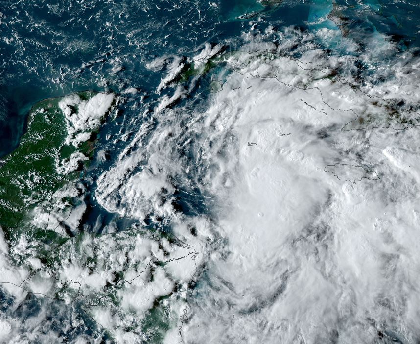
An area of disturbed weather is slowly organizing in the western Caribbean Sea. Forecast models have been hinting at a tropical cyclone moving into the eastern Gulf of Mexico for several days now. In fact models have been suggesting a tropical cyclone in the Gulf for well over a week.

The Weather Situation
SUMMARY OF 800 PM EDT...0000 UTC...INFORMATION
----------------------------------------------
LOCATION...18.3N 82.3W
ABOUT 100 MI...160 KM SW OF GRAND CAYMAN
ABOUT 300 MI...485 KM SE OF THE WESTERN TIP OF CUBA
MAXIMUM SUSTAINED WINDS...35 MPH...55 KM/H
PRESENT MOVEMENT...NNW OR 345 DEGREES AT 7 MPH...11 KM/H
MINIMUM CENTRAL PRESSURE...1002 MB...29.59 INCHES

Tropicast: Visible Satellite RAMMB / CIRA Slider Monday evening
Image

Tropical Weather Forecast:
PTC 9 is expected to become tropical storm Helene later tonight and strengthen into a hurricane as it moves through the Yucatan channel by Tuesday night. It will be pulled northward by upper air southwesterly winds as it picks up forward speed into the eastern Gulf of Mexico. It may strengthen into a major hurricane and make landfall later in the day Thursday over the northeastern Gulf coast. The effects of storm surge, damaging winds and flash flooding can be expected.

It will then move into Georgia Thursday night and early Friday. Due to its significant forward speed, damaging winds will likely move well inland.
Rich Johnson
Twitter: https://twitter.com/richjohnsonwx
Certified Broadcast Meteorologist - Hurricane Expert
User avatar
Tropical Inspector
Site Admin
Site Admin
Posts: 3697
Joined: Tue Feb 20, 2007 2:28 pm
Antispam: no
Location: Under a palm tree
Contact:

Re: Helene

Post by Tropical Inspector »

Tuesday Afternoon Update
Helene forms in NW Caribbean.

Visible satellite imagery clearly shows the low level circulation of Helene. Very deep convection is east of the low center with some convection now near the center.

The Weather Situation
SUMMARY OF 1100 AM EDT...1500 UTC...INFORMATION
-----------------------------------------------
LOCATION...19.5N 84.3W
ABOUT 180 MI...295 KM ESE OF COZUMEL MEXICO
ABOUT 170 MI...275 KM SSE OF THE WESTERN TIP OF CUBA
MAXIMUM SUSTAINED WINDS...45 MPH...75 KM/H
PRESENT MOVEMENT...NW OR 310 DEGREES AT 12 MPH...19 KM/H
MINIMUM CENTRAL PRESSURE...1000 MB...29.53 INCHES

Tropicast: Visible Satellite RAMMB / CIRA Slider Tuesday Late Morning
Image

Tropical Weather Forecast:
Helene is expected to strengthen into a hurricane as it moves through the Yucatan channel into the Gulf by Tuesday night / Wednesday morning. It will be pulled northward by upper air southwesterly winds as it picks up forward speed into the eastern Gulf of Mexico. It may strengthen into a major hurricane and make landfall later in the day Thursday over the northeastern Gulf coast. The effects of storm surge, damaging winds and flash flooding can be expected.

It will then move into Georgia Thursday night and early Friday. Due to its significant forward speed, damaging winds will likely move well inland.
Rich Johnson
Twitter: https://twitter.com/richjohnsonwx
Certified Broadcast Meteorologist - Hurricane Expert
User avatar
Tropical Inspector
Site Admin
Site Admin
Posts: 3697
Joined: Tue Feb 20, 2007 2:28 pm
Antispam: no
Location: Under a palm tree
Contact:

Re: Helene

Post by Tropical Inspector »

Wednesday Morning Update
Helene will be a hurricane soon

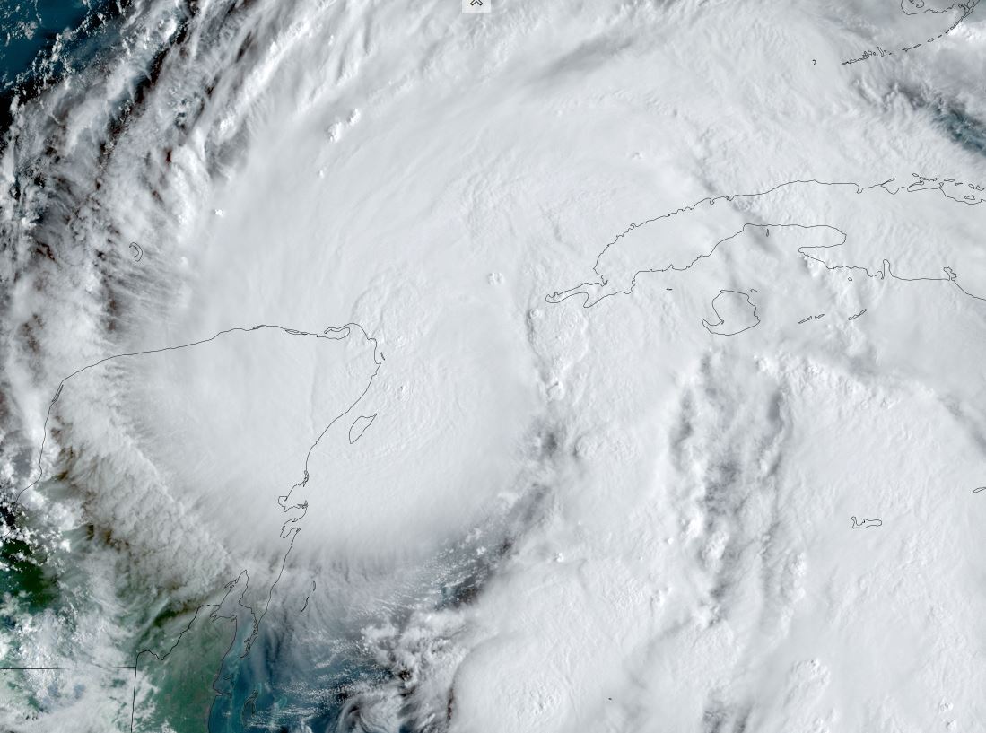
Visible satellite imagery shows a solid central dense overcast as well as transverse banding aloft indicating excellent outflow. Atmospheric conditions are favorable for significant strengthening.

The Weather Situation
SUMMARY OF 700 AM CDT...1200 UTC...INFORMATION
----------------------------------------------
LOCATION...21.1N 86.2W
ABOUT 60 MI...100 KM ENE OF COZUMEL MEXICO
ABOUT 100 MI...160 KM WSW OF THE WESTERN TIP OF CUBA
MAXIMUM SUSTAINED WINDS...70 MPH...110 KM/H
PRESENT MOVEMENT...NW OR 325 DEGREES AT 9 MPH...15 KM/H
MINIMUM CENTRAL PRESSURE...979 MB...28.91 INCHES

Tropicast: Visible Satellite RAMMB / CIRA Slider Wednesday Morning
Image

Tropical Weather Forecast:
Helene will be pulled northward by upper air southwesterly winds as it picks up forward speed into the eastern Gulf of Mexico today and Thursday. It will strengthen into a major hurricane and make landfall later in the day Thursday over the northeastern Gulf coast. The effects of storm surge, damaging winds and flash flooding can be expected.

It will then move into Georgia Thursday night and early Friday. Due to its significant forward speed, damaging winds will likely move well inland. The Atlanta metro area will likely see flooding rainfall, damaging winds / power outages.
Rich Johnson
Twitter: https://twitter.com/richjohnsonwx
Certified Broadcast Meteorologist - Hurricane Expert
User avatar
Tropical Inspector
Site Admin
Site Admin
Posts: 3697
Joined: Tue Feb 20, 2007 2:28 pm
Antispam: no
Location: Under a palm tree
Contact:

Re: Helene

Post by Tropical Inspector »

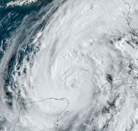
Wednesday Evening Update
Helene over southern Gulf of Mexico

Satellite imagery indicates that deep convection continues to develop near the circulation center. The latest aircraft recon showed winds around 70 knots which is a little weaker than the previous estimate. This however is likely due to the fact of possibly missing the strongest winds and not indicative of true weakening. A rapid deepening phase is possible on Thursday over the eastern Gulf of Mexico.

The Weather Situation
SUMMARY OF 700 PM CDT...0000 UTC...INFORMATION
----------------------------------------------
LOCATION...23.0N 86.6W
ABOUT 430 MI...690 KM SW OF TAMPA FLORIDA
ABOUT 475 MI...760 KM SSW OF APALACHICOLA FLORIDA
MAXIMUM SUSTAINED WINDS...85 MPH...140 KM/H
PRESENT MOVEMENT...N OR 360 DEGREES AT 12 MPH...19 KM/H
MINIMUM CENTRAL PRESSURE...974 MB...28.76 INCHES

Tropicast: Visible Satellite RAMMB / CIRA Slider Wednesday Evening
Image

Tropical Weather Forecast:
Helene will be pulled northward by upper air southwesterly winds as it picks up forward speed into the eastern Gulf of Mexico Thursday. It will strengthen into a major hurricane and make landfall later in the day Thursday over the northeastern Gulf coast. The effects of storm surge, damaging winds and flash flooding can be expected. :!: Very high storm tides of 15-20 feet may be seen over the coastal Big Bend of Florida.

Helene will move into Georgia Thursday night and early Friday. Due to its significant forward speed, damaging winds will likely move well inland. The Atlanta metro area will likely see flooding rainfall, damaging winds / power outages.
Rich Johnson
Twitter: https://twitter.com/richjohnsonwx
Certified Broadcast Meteorologist - Hurricane Expert
User avatar
Tropical Inspector
Site Admin
Site Admin
Posts: 3697
Joined: Tue Feb 20, 2007 2:28 pm
Antispam: no
Location: Under a palm tree
Contact:

Re: Helene

Post by Tropical Inspector »

Thursday Morning Update
Helene trying to strengthen

IR satellite imagery this morning shows very deep convection of the east side of the circulation. Recon has relayed to NHC that two concentric eyewalls have developed. This has slowed organization as changes are ongoing in the inner structure. It is still expected to become a major hurricane later today before landfall as there is still potential for a rapid deepening cycle.

The Weather Situation
SUMMARY OF 400 AM CDT...0900 UTC...INFORMATION
----------------------------------------------
LOCATION...24.2N 86.2W
ABOUT 350 MI...560 KM SW OF TAMPA FLORIDA
ABOUT 385 MI...625 KM S OF APALACHICOLA FLORIDA
MAXIMUM SUSTAINED WINDS...90 MPH...150 KM/H
PRESENT MOVEMENT...NNE OR 15 DEGREES AT 12 MPH...19 KM/H
MINIMUM CENTRAL PRESSURE...966 MB...28.53 INCHES

Tropicast: IR Satellite RAMMB / CIRA Slider Thursday Morning
Image

Tropical Weather Forecast:
Helene will be pulled northward by upper air southwesterly winds as it picks up forward speed over the eastern Gulf of Mexico today. It will still likely strengthen into a major hurricane and make landfall this evening or very early Friday morning over the Big Bend coast of Florida. The effects of storm surge, damaging winds and flash flooding can be expected. :!: Very high storm tides of 15-20 feet may be seen over the coastal Big Bend of Florida.

Helene will move into Georgia Thursday night and Friday. Due to its significant forward speed, damaging winds will likely move well inland. The strongest winds will likely be in a swath from the Big Bend of Florida into parts of south, middle Georgia into the higher elevations of the southern Appalachians. The Atlanta metro area will likely see flooding rainfall, damaging winds / power outages.
Rich Johnson
Twitter: https://twitter.com/richjohnsonwx
Certified Broadcast Meteorologist - Hurricane Expert
User avatar
Tropical Inspector
Site Admin
Site Admin
Posts: 3697
Joined: Tue Feb 20, 2007 2:28 pm
Antispam: no
Location: Under a palm tree
Contact:

Re: Helene

Post by Tropical Inspector »

Thursday Late Afternoon Update
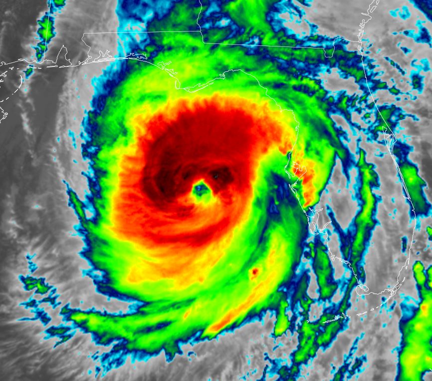
Helene has strengthened

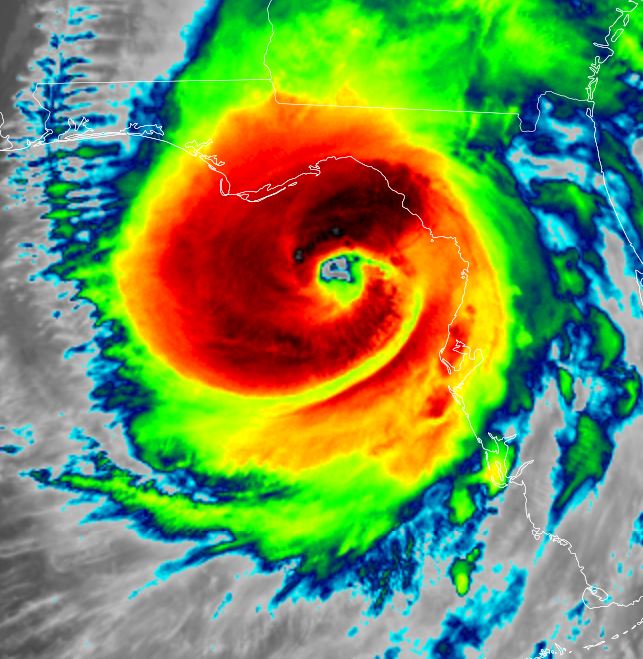
Helene has been trying all day to close off the eye wall. That has occurred recently as very deep convection has totally wrapped around the center. It has been slowly strengthening all day, but additional strengthening is likely before landfall on the Big Bend of Florida late this evening.

The Weather Situation
SUMMARY OF 500 PM EDT...2100 UTC...INFORMATION
----------------------------------------------
LOCATION...27.9N 84.6W
ABOUT 130 MI...205 KM W OF TAMPA FLORIDA
ABOUT 175 MI...280 KM S OF TALLAHASSEE FLORIDA
MAXIMUM SUSTAINED WINDS...125 MPH...205 KM/H
PRESENT MOVEMENT...NNE OR 25 DEGREES AT 23 MPH...37 KM/H
MINIMUM CENTRAL PRESSURE...951 MB...28.09 INCHES

Tropicast: IR Satellite RAMMB / CIRA Slider LateThursday Afternoon
Image

Tropicast: Visible Satellite RAMMB / CIRA Slider Late Thursday Afternoon
Image

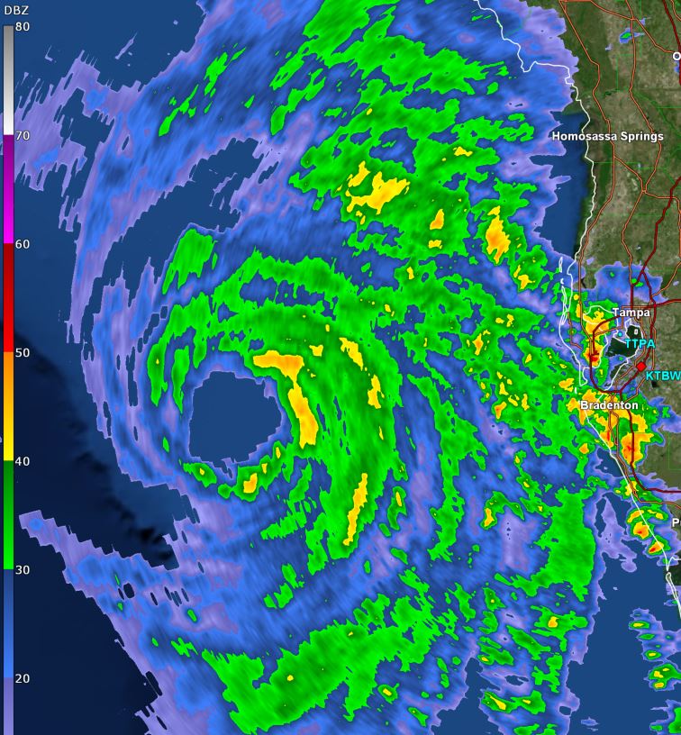
Tropicast: Tampa Radar 4:45 pm edt
Image

Tropical Weather Forecast:
Helene will make landfall late this evening or around midnight on the Big Bend coast of Florida. It will then move northward across Georgia tonight into Friday morning. The effects of storm surge, damaging winds and flash flooding can be expected. :!: Very high storm tides of 15-20 feet may be seen over the coastal Big Bend of Florida.

Due to Helene's significant forward speed, damaging winds will likely move well inland. The strongest winds will likely be in a swath from the Big Bend of Florida into parts of south, middle Georgia into the higher elevations of the southern Appalachians. The Atlanta metro area will likely see flooding rainfall, damaging winds / power outages.
Rich Johnson
Twitter: https://twitter.com/richjohnsonwx
Certified Broadcast Meteorologist - Hurricane Expert
User avatar
Tropical Inspector
Site Admin
Site Admin
Posts: 3697
Joined: Tue Feb 20, 2007 2:28 pm
Antispam: no
Location: Under a palm tree
Contact:

Re: Helene

Post by Tropical Inspector »

Thursday Evening Update
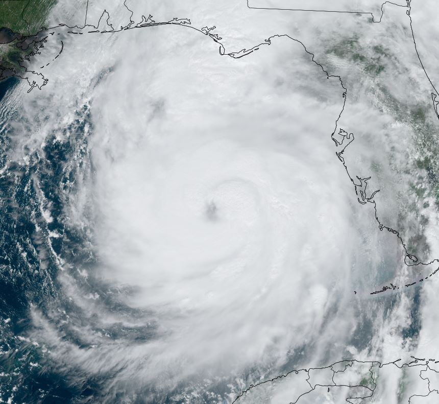
Helene making landfall in a few hours

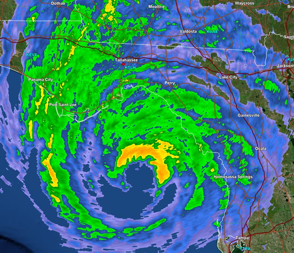
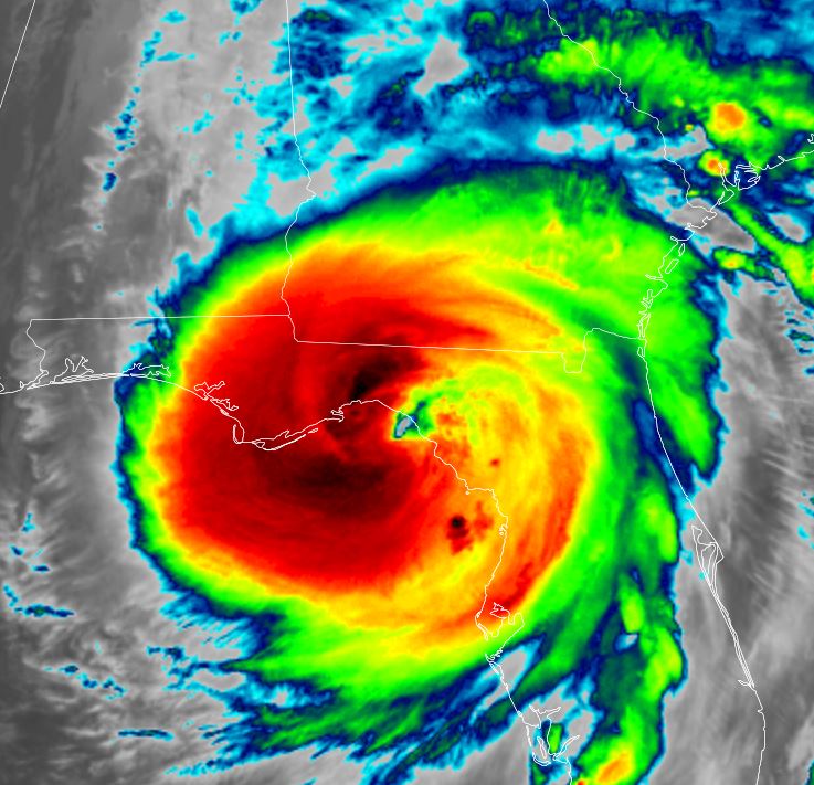
Helene has been strengthening rapidly before landfall. The pressure has dropped steadily and the eyewall has grown in size.

The Weather Situation
SUMMARY OF 800 PM EDT...0000 UTC...INFORMATION
----------------------------------------------
LOCATION...28.7N 84.3W
ABOUT 80 MI...125 KM WSW OF CEDAR KEY FLORIDA
ABOUT 115 MI...190 KM S OF TALLAHASSEE FLORIDA
MAXIMUM SUSTAINED WINDS...130 MPH...215 KM/H
PRESENT MOVEMENT...NNE OR 25 DEGREES AT 23 MPH...37 KM/H
MINIMUM CENTRAL PRESSURE...942 MB...27.82 INCHES

Tropicast: IR Satellite RAMMB / CIRA Slider Thursday Evening
Image

Tropicast: Visible Satellite RAMMB / CIRA Slider Thursday Evening
Image

Tropicast: Tallahassee Radar 8:17 pm edt
Image

Tropical Weather Forecast:
Helene will make landfall late this evening or around midnight on the Big Bend coast of Florida. It will then move northward across Georgia tonight into Friday morning. The effects of storm surge, damaging winds and flash flooding can be expected. :!: Very high storm tides of 15-20 feet may be seen over the coastal Big Bend of Florida.

Due to Helene's significant forward speed, damaging winds will likely move well inland. The strongest winds will likely be in a swath from the Big Bend of Florida into parts of south, middle Georgia into the higher elevations of the southern Appalachians. The Atlanta metro area will likely see flooding rainfall, damaging winds / power outages.
Rich Johnson
Twitter: https://twitter.com/richjohnsonwx
Certified Broadcast Meteorologist - Hurricane Expert
User avatar
Tropical Inspector
Site Admin
Site Admin
Posts: 3697
Joined: Tue Feb 20, 2007 2:28 pm
Antispam: no
Location: Under a palm tree
Contact:

Re: Helene

Post by Tropical Inspector »

Friday Morning Update
Heavy rainfall continues with Helene

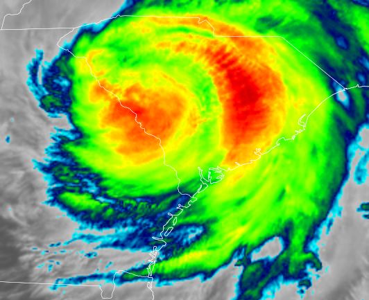
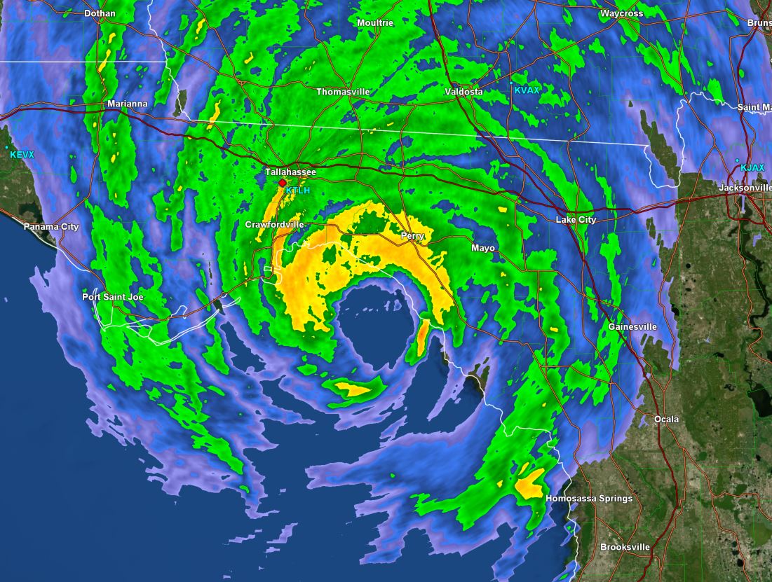
Helene made landfall at 11:10pm last night just east of the mouth of the Aucilla river with a pressure of 938 mb. Top sustained surface winds were estimated at 140 mph. This is a sparsely populated coast of the Big Bend of Florida.

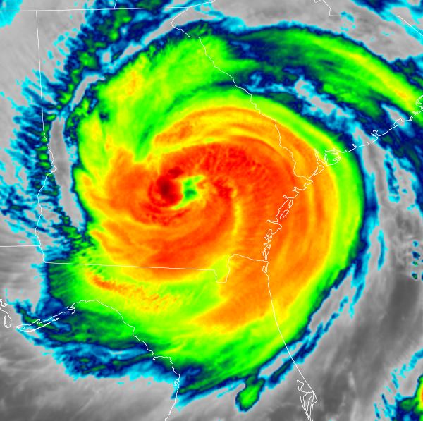
Helene is now over eastern Georgia to the east of Athens. This is well east of the official NHC prediction from last night. NHC usually does an excellent job with track forecast..... Over the past days the GFS model was the outlier to the east of the consensus models. The consensus is correct many more times than an individual model. This time around though the GFS was quite accurate. This change in path spared the Atlanta metro area from damaging winds.

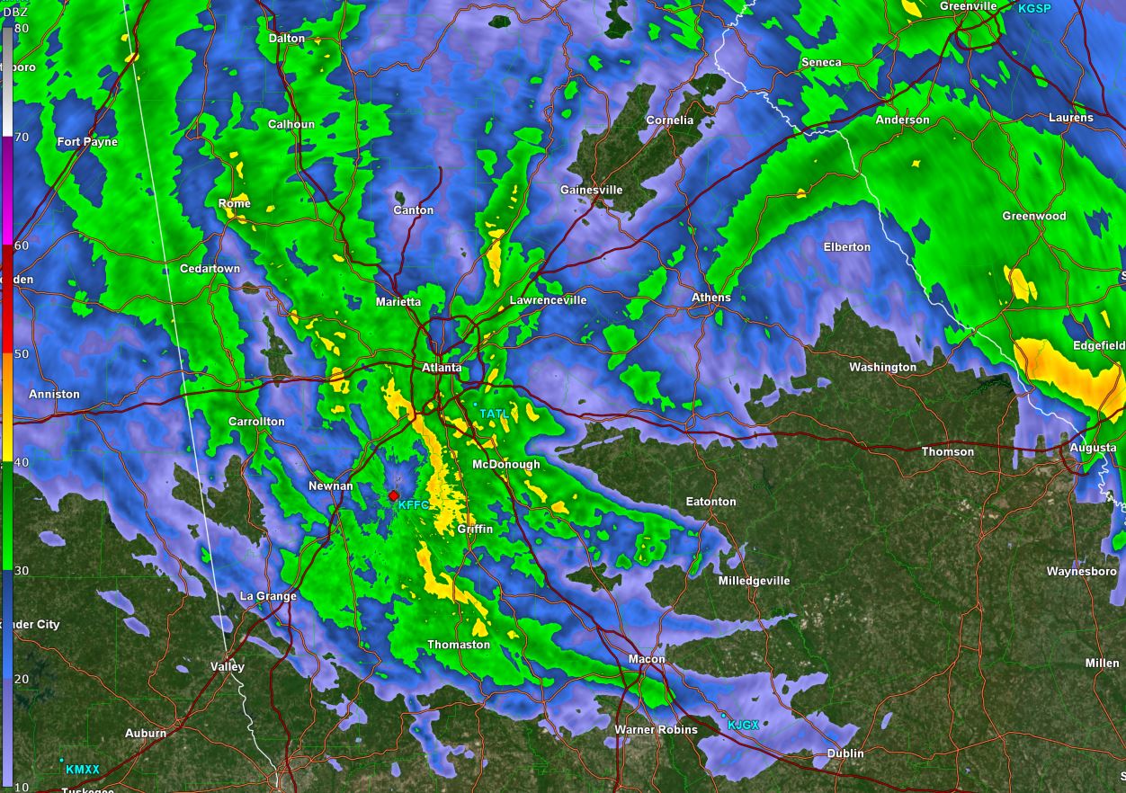
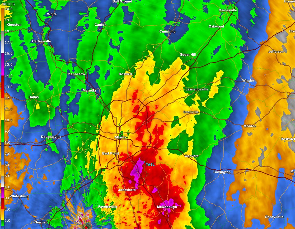
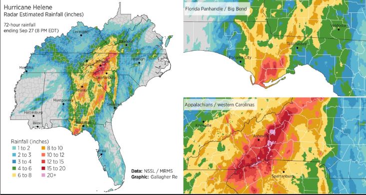
Heavy rainfall continues over north Georgia and flood warnings continue around Atlanta. So far, rainfall totals have exceeded 8" with generally 4-8" over the entire area. Another 2-4" is likely before Helene moves into the southern Appalachians.

The Weather Situation
SUMMARY OF 500 AM EDT...0900 UTC...INFORMATION
----------------------------------------------
LOCATION...32.8N 83.0W
ABOUT 40 MI...65 KM E OF MACON GEORGIA
ABOUT 100 MI...165 KM SE OF ATLANTA GEORGIA
MAXIMUM SUSTAINED WINDS...70 MPH...110 KM/H
PRESENT MOVEMENT...N OR 360 DEGREES AT 30 MPH...48 KM/H
MINIMUM CENTRAL PRESSURE...968 MB...28.59 INCHES

Tropicast: IR Satellite RAMMB / CIRA Slider Friday Morning 6 am
Image

Tropicast: IR Satellite RAMMB / CIRA Slider Friday Morning 2am
Image

Tropicast: IR Satellite RAMMB / CIRA Slider Thursday Night 11pm
Image

Tropicast: Atlanta Radar 6am Friday Morning edt
Image

Tropicast: Tallahassee Radar 10:45 pm edt Thursday Evening
Image

Tropical Weather Forecast:
Helene will continue today into the southern Appalachians. Flooding rainfall will be seen across north Georgia into the southern Appalachians. Wind damage also continues to be a threat in the higher elevations of the southern Appalachians.

Official NHC Public Advisory
https://www.nhc.noaa.gov/text/refresh/M ... 853.shtml?

Official NHC Track
https://www.nhc.noaa.gov/refresh/graphi ... e#contents
Rich Johnson
Twitter: https://twitter.com/richjohnsonwx
Certified Broadcast Meteorologist - Hurricane Expert
User avatar
Tropical Inspector
Site Admin
Site Admin
Posts: 3697
Joined: Tue Feb 20, 2007 2:28 pm
Antispam: no
Location: Under a palm tree
Contact:

Re: Helene

Post by Tropical Inspector »

Friday Evening Update

Rainfall estimate north Georgia - GR Level 3
Image

Rainfall estimates
Image
Rich Johnson
Twitter: https://twitter.com/richjohnsonwx
Certified Broadcast Meteorologist - Hurricane Expert
Post Reply

Return to “2024 Atlantic Hurricane Updates”

Who is online

Users browsing this forum: No registered users and 1 guest