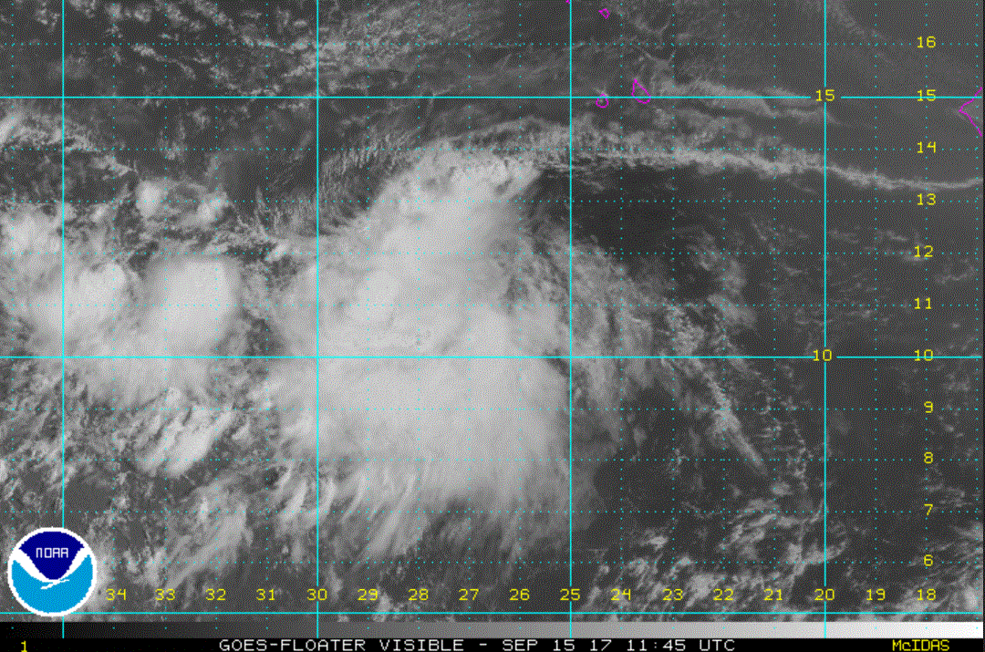
The Weather Situation Increased organization of an area of disturbed weather shows rotation this morning in the far eastern tropical Atlantic. This are will likely be classified as Lee later today.
Current Tropical Weather As of 5:00 AM AST 14L was centered at 10.6 N / 27.3 W or 435 miles SSW of the Cabo Verde Islands. It was moving west at 14 mph. Top sustained winds are estimated at 35 mph. Pressure was estimated at 1008 MB.
Tropical Weather Forecast: 14 L is forecast to move west in the deep tropics for a few days and strengthen. After that an upper air trough is forecast to increase wind shear and turn it NW. This will also weaken the tropical cyclone.
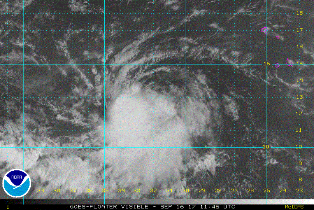
The Weather Situation TD 14 has been fighting wind shear still. The shear may relax enough for it to be upgraded to Lee. In fact, the latest satellite imagery shows that convection has increased enough that NHC may classify it on the next update. It will likely then weaken again as an upper air trough weakens it again.
Current Tropical Weather As of 5:00 AM AST 14L was centered at 12.6 N / 32.1 W or 590 miles WSW of the Cabo Verde Islands. It was moving west at 7 mph. Top sustained winds are estimated at 35 mph. Pressure was estimated at 1008 MB.
Tropical Weather Forecast: 14 L is forecast to move west in the deep tropics for a few days and strengthen briefly. After that an upper air trough is forecast to increase wind shear and turn it NW. This will also weaken the tropical cyclone.
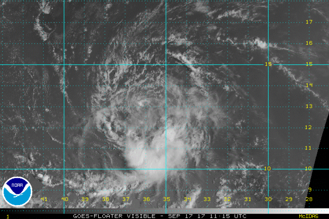
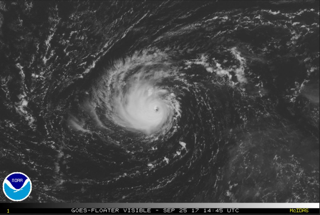
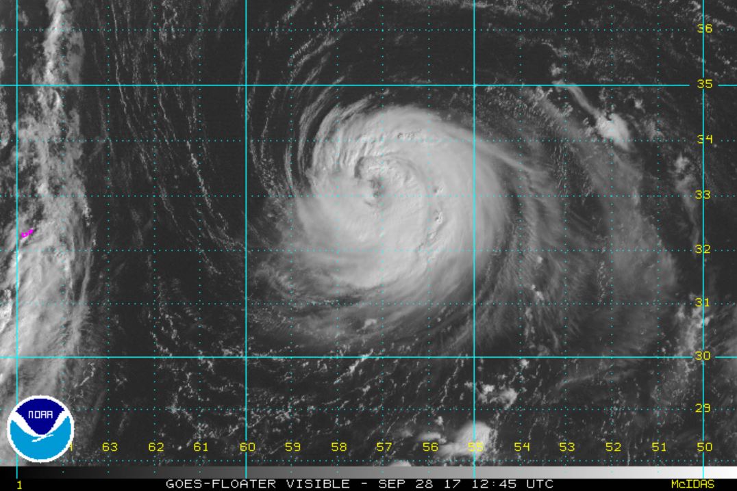
The Weather Situation Lee was classified Saturday afternoon. The satellite imagery of Lee show a badly sheared system again. It likely is no longer a tropical storm. The only convectionremaining is well south of the circulation center.
Current Tropical Weather As of 5:00 AM AST Lee was centered at 13.0 N / 35.4 W or 790 miles WSW of the Cabo Verde Islands. It was moving west at 7 mph. Top sustained winds are estimated at 40 mph. Pressure was estimated at 1007 MB.
Tropical Weather Forecast: Shearing will continue and Lee will lose its tropical characteristics.
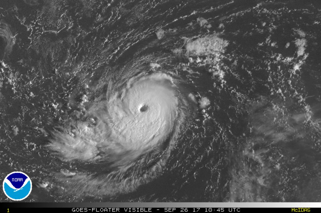
The Weather Situation Lee was classified as a tropical storm again yesterday. It is rapidly strengthening and is likely stronger than the official NHC estimate of 85 mph.
Current Tropical Weather As of 5:00 AM AST Lee was centered at 31.8 N / 50.1 W or 860 miles east of Bermuda. It was moving south at 1 mph. Top sustained winds are estimated at 85 mph. Pressure was estimated at 983 MB.
Tropical Weather Forecast: Lee will continue to not pose treat to land.
The Weather Situation Lee remains a very small hurricane with hurricane force winds estimated to only extend 10 miles from the center.
Current Tropical Weather As of 11:00 AM AST Lee was centered at 30.8 N / 49.9 W or 880 miles east of Bermuda. It was moving SSW at 2 mph. Top sustained winds are estimated at 90 mph. Pressure was estimated at 980 MB.
Tropical Weather Forecast: Lee will continue to not pose treat to land. It will drift west for a few days, then accelerate NE as it is picked up by an upper air trough.
The Weather Situation Lee's eye wall has widened and cloud tops have cooled some indicating some strengthening.
Current Tropical Weather As of 5:00 AM AST Lee was centered at 30.0 N / 52.5 W or 745 miles east of Bermuda. It was moving west at 10 mph. Top sustained winds are estimated at 100 mph. Pressure was estimated at 977 MB.
Tropical Weather Forecast: Lee will continue to not pose treat to land. It will drift west for a few days, then accelerate NE as it is picked up by an upper air trough.
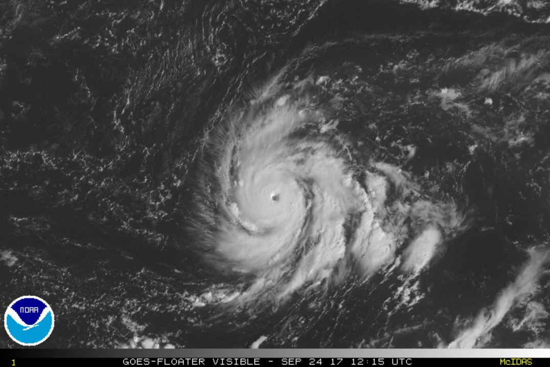
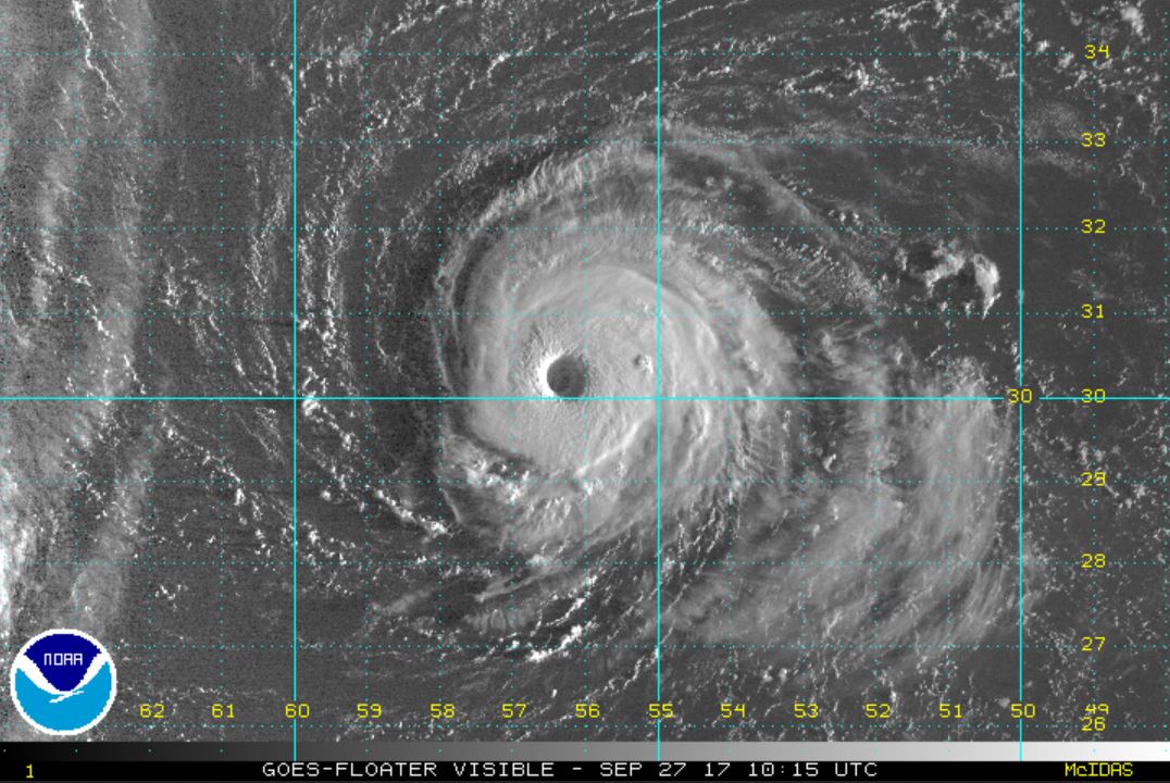
The Weather Situation Lee's eye wall has widened more. It is on the verge of becoming a cat 3 hurricane.
Current Tropical Weather As of 5:00 AM AST Lee was centered at 30.2 N / 56.3 W or 520 miles ESE of Bermuda. It was moving WNW at 9 mph. Top sustained winds are estimated at 110 mph. Pressure was estimated at 971 MB.
Tropical Weather Forecast: Lee will continue to not pose treat to land. It will drift NW today, then accelerate NE as it is picked up by an upper air trough starting by Friday.
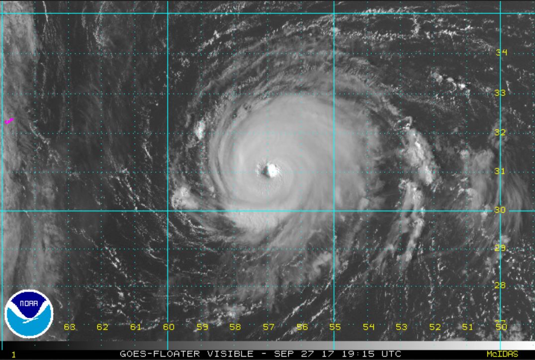
The Weather Situation Lee seems to be fighting a little northerly shear as the convection on the north side of the tropical cyclone is not as impressive as to the south.
Current Tropical Weather As of 5:00 AM AST Lee was centered at 32.5 N / 57.2 W or 1735 miles west of the Azores. It was moving north at 9 mph. Top sustained winds are estimated at 110 mph. Pressure was estimated at 971 MB.
Tropical Weather Forecast: Lee will not pose treat to land. It will accelerate NE as it is picked up by an upper air trough starting by tomorrow.
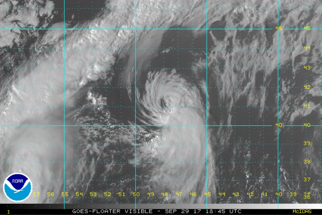
The Weather Situation Lee is badly sheared and is dissipating. It is accelerating northeast at over 35 mph.
Current Tropical Weather As of 5:00 PM AST Lee was centered at 42.2 N / 46.0 W or 1040 miles WNW of the Azores. It was moving NE at 36 mph. Top sustained winds are estimated at 65 mph. Pressure was estimated at 996 MB.
Tropical Weather Forecast: This is the last update on Lee.