Ana

Tropical cyclone archives of the 2014 eastern and central Pacific hurricane season

Moderator: Florida Beach Gal

Post Reply
User avatar
Tropical Inspector
Site Admin
Site Admin
Posts: 3630
Joined: Tue Feb 20, 2007 2:28 pm
Antispam: no
Location: Under a palm tree
Contact:

Ana

Post by Tropical Inspector »

Wednesday Morning Update

Ana headed toward Hawaii

The Weather Situation
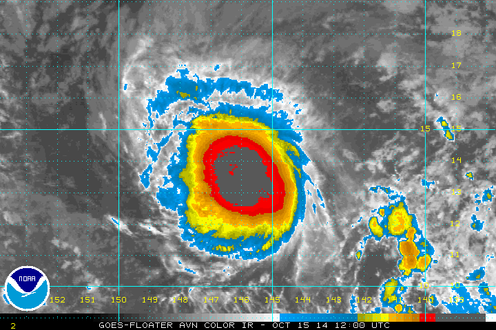
Ana has strengthened and will likely be classified as a minimal hurricane during the next few hours. Ana poses a real threat to Hawaii by late Friday into the weekend. Hurricane effects may be seen if Ana is pulled far enough northward. It is too early to tell the exact impacts that will be seen.

Current Tropical Weather
As of 11 PM HST / 5 AM EDT Tropical storm Ana was centered at 14.1 N / 146.1 W or about 710 miles ESE Hilo, Hawaii / 920 ESE of Honolulu, Hawaii. It was moving west at about 9 mph. Top sustained winds are estimated at 70 mph. Pressure was estimated at 994 mb.

Tropical Weather Forecast:
Ana is expected to move on a WNW course which will take it toward Hawaii as a hurricane by late Friday (south of the Big Island) to the weekend near or south of the central and western Hawaiian islands. It is unclear if the strongest part of the hurricane will stay offshore at this time. Interests in Hawaii should monitor the progress of Ana closely.

Tropicast: Pacific IR Satellite
Image
Rich Johnson
Twitter: https://twitter.com/richjohnsonwx
Certified Broadcast Meteorologist - Hurricane Expert
User avatar
Tropical Inspector
Site Admin
Site Admin
Posts: 3630
Joined: Tue Feb 20, 2007 2:28 pm
Antispam: no
Location: Under a palm tree
Contact:

Re: Ana

Post by Tropical Inspector »

Wednesday Evening Update

Ana still a tropical storm

The Weather Situation
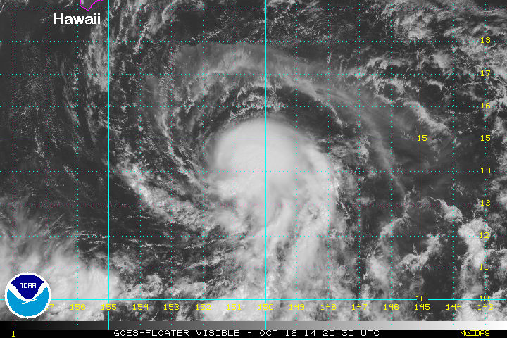
A bursting pattern is currently observed over Ana. This indicates very deep convection and possibly a strengthening phase beginning. The central pacific hurricane center is still holding Ana just below hurricane strength at this time.

Current Tropical Weather
As of 11 AM HST / 5 PM EDT Tropical storm Ana was centered at 14.3 N / 147.4 W or about 630 miles SE Hilo, Hawaii / 84020 ESE of Honolulu, Hawaii. It was moving west at about 9 mph. Top sustained winds are estimated at 70 mph. Pressure was estimated at 994 mb.

Tropical Weather Forecast:
Ana is expected to move on a WNW course which will take it toward Hawaii as a hurricane by late Friday (south of the Big Island) to the weekend near or south of the central and western Hawaiian islands. It is unclear if the strongest part of the hurricane will stay offshore at this time. Interests in Hawaii should monitor the progress of Ana closely.

Tropicast: Pacific Visible Satellite
Image
Rich Johnson
Twitter: https://twitter.com/richjohnsonwx
Certified Broadcast Meteorologist - Hurricane Expert
User avatar
Tropical Inspector
Site Admin
Site Admin
Posts: 3630
Joined: Tue Feb 20, 2007 2:28 pm
Antispam: no
Location: Under a palm tree
Contact:

Re: Ana

Post by Tropical Inspector »

Thursday morning Update

Ana sheared badly

The Weather Situation
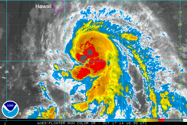
The bursting pattern last night did not result in strengthening. Wind shear took over and has ripped up the cloud structure. This is good news for Hawaii as strengthening has been disrupted. My estimate for wind speed is lower than the official CPHC's estimate.

Current Tropical Weather
As of 11 PM HST / 5 AM EDT Tropical storm Ana was centered at 14.1 N / 149.3 W or about 545 miles SE Hilo, Hawaii / 755 miles SE of Honolulu, Hawaii. It was moving west at about 10 mph. Top sustained winds are estimated at 50 mph (60 mph CPHC). Pressure was estimated at 1000 mb.

Tropical Weather Forecast:
Forecast models have shifted south which is great news. This may now mean that Ana will not make landfall. Also, wind shear will be closely watch as it's possible that Ana will not restrengthen as a hurricane. Interests in Hawaii should monitor the progress of Ana closely.

Tropicast: Pacific IR Satellite
Image
Rich Johnson
Twitter: https://twitter.com/richjohnsonwx
Certified Broadcast Meteorologist - Hurricane Expert
User avatar
Tropical Inspector
Site Admin
Site Admin
Posts: 3630
Joined: Tue Feb 20, 2007 2:28 pm
Antispam: no
Location: Under a palm tree
Contact:

Re: Ana

Post by Tropical Inspector »

Thursday Evening Update

Ana regaining some strength

The Weather Situation
Ana is still facing westerly wind shear. The deep convection surrounding the low center was disrupted over the past 12 hours, but has recently come back. Winds may again now be back to the official estimate of 60 mph.

Current Tropical Weather
As of 11 AM HST / 5 PM EDT Tropical storm Ana was centered at 14.3 N / 150.9 W or about 465 miles SE Hilo, Hawaii / 655 miles SE of Honolulu, Hawaii. It was moving west at about 8 mph. Top sustained winds are estimated at 60 mph . Pressure was estimated at 1000 mb.

Tropical Weather Forecast:
The official CPHC forecast now reflects more of the models trend that was advertised this morning. The official track has been shifted south so that Ana now does not make landfall. It will still be close enough to produce unsettled weather. Interests in Hawaii should monitor the progress of Ana closely.

Tropicast: Pacific Visible Satellite
Image
Rich Johnson
Twitter: https://twitter.com/richjohnsonwx
Certified Broadcast Meteorologist - Hurricane Expert
User avatar
Tropical Inspector
Site Admin
Site Admin
Posts: 3630
Joined: Tue Feb 20, 2007 2:28 pm
Antispam: no
Location: Under a palm tree
Contact:

Re: Ana

Post by Tropical Inspector »

Friday Morning Update

Ana's track a little farther south

The Weather Situation
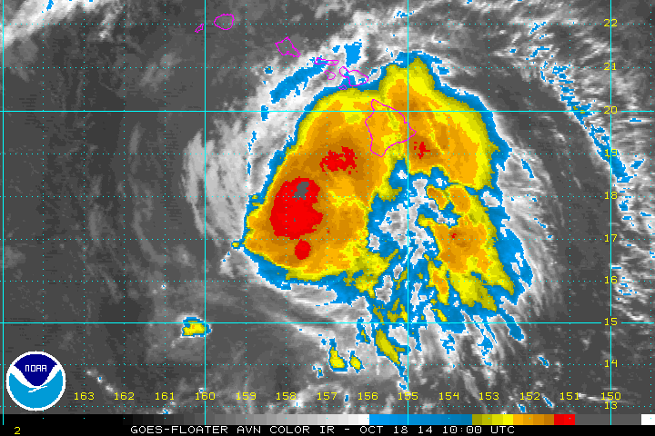
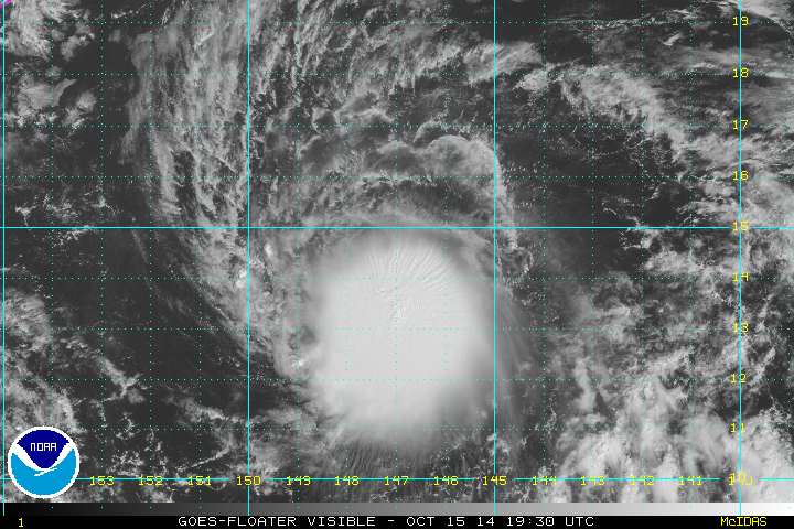
Satellite imagery shows that Ana is becoming better organized and will likely become a minimal hurricane within 24 hrs. Wind shear has lessened and deep convection has built around the center of circulation allowing for this increase. The Big Island of Hawaii now appears on the satellite image in the top left corner below. Effects from Tropical Storm Ana will begin to affect the Big Island later today.

Current Tropical Weather
As of 11 PM HST / 5 AM EDT Tropical storm Ana was centered at 15.2 N / 153.0 W or about 340 miles SSE Hilo, Hawaii / 530 miles SE of Honolulu, Hawaii. It was moving WNW at about 14 mph. Top sustained winds are estimated at 65 mph . Pressure was estimated at 998 mb.

Tropical Weather Forecast:
The official central pacific hurricane center forecast shows the track shifting south. This is from a new ridge of high pressure that will build over the region forcing Ana to move more west as it approaches the western Hawaiian Islands. The timing of the turn will be important for this turn to occur. Effects will still be felt across the Islands, especially on the south facing shores. Interests in Hawaii should monitor the progress of Ana closely.

Tropicast: Pacific IR Satellite
Image
Rich Johnson
Twitter: https://twitter.com/richjohnsonwx
Certified Broadcast Meteorologist - Hurricane Expert
User avatar
Tropical Inspector
Site Admin
Site Admin
Posts: 3630
Joined: Tue Feb 20, 2007 2:28 pm
Antispam: no
Location: Under a palm tree
Contact:

Re: Ana

Post by Tropical Inspector »

Friday Evening Update

Ana now officially a hurricane

The Weather Situation
Satellite imagery shows deeper convection associated with Ana. This increase has allowed the tropical cyclone to be classified as a hurricane.

Current Tropical Weather
As of 11 AM HST / 5 PM EDT Tropical storm Ana was centered at 16.4 N / 155.2 W or about 230 miles south of Hilo, Hawaii / 380 miles SE of Honolulu, Hawaii. It was moving WNW at about 14 mph. Top sustained winds are estimated at 75 mph . Pressure was estimated at 990 mb.

Tropical Weather Forecast:
The track has again been nudged a bit south. This will allow the worst of the effects to remain offshore south of the Islands this weekend. Interests in Hawaii should monitor the progress of Ana closely.

Tropicast: Pacific Visible Satellite
Image
Rich Johnson
Twitter: https://twitter.com/richjohnsonwx
Certified Broadcast Meteorologist - Hurricane Expert
User avatar
Tropical Inspector
Site Admin
Site Admin
Posts: 3630
Joined: Tue Feb 20, 2007 2:28 pm
Antispam: no
Location: Under a palm tree
Contact:

Re: Ana

Post by Tropical Inspector »

Friday Night Update

Ana changes little

The Weather Situation
No important changes to Ana. Most rain associated with Ana remains offshore.

Current Tropical Weather
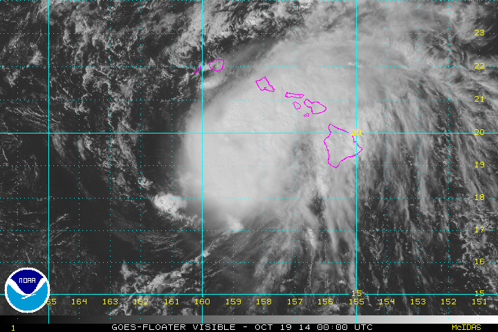
As of 5 PM HST / 11 PM EDT Hurricane Ana was centered at 17.0 N / 156.6 W or about 310 miles SSE of Honolulu, Hawaii. It was moving NW at about 14 mph. Top sustained winds are estimated at 80 mph . Pressure was estimated at 986 mb.

Tropical Weather Forecast:
The worst of the effects should remain offshore south of the Islands this weekend. Interests in Hawaii should monitor the progress of Ana closely.

Tropicast: Pacific Visible Satellite
Image
Rich Johnson
Twitter: https://twitter.com/richjohnsonwx
Certified Broadcast Meteorologist - Hurricane Expert
User avatar
Tropical Inspector
Site Admin
Site Admin
Posts: 3630
Joined: Tue Feb 20, 2007 2:28 pm
Antispam: no
Location: Under a palm tree
Contact:

Re: Ana

Post by Tropical Inspector »

Saturday Morning Update

Ana passing south of Hawaii

The Weather Situation
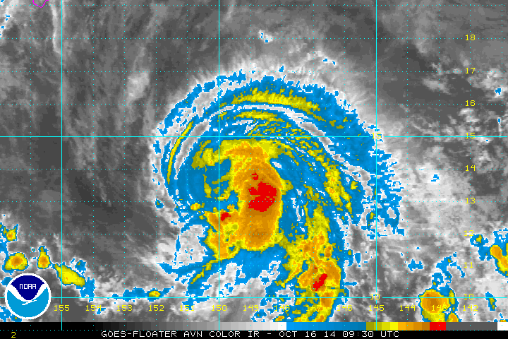
Ana is remaining south of the Hawaiian Islands. This means no direct landfall today, but some rain bands will brings squall with winds possibly to tropical storm force. Deep convection surrounds the low center, but the system looks a bit disorganized still with no apparent eye.

Current Tropical Weather
As of 11 PM HST / 5 AM EDT Hurricane Ana was centered at 17.8 N / 157.4 W or about 245 miles south of Honolulu, Hawaii. It was moving NW at about 13 mph. Top sustained winds are estimated at 85 mph . Pressure was estimated at 985 mb.

Tropical Weather Forecast:
The worst of the effects will remain offshore south of the Islands this weekend. Interests in Hawaii should monitor the progress of Ana closely.

Tropicast: Pacific IR Satellite
Image
Rich Johnson
Twitter: https://twitter.com/richjohnsonwx
Certified Broadcast Meteorologist - Hurricane Expert
User avatar
Tropical Inspector
Site Admin
Site Admin
Posts: 3630
Joined: Tue Feb 20, 2007 2:28 pm
Antispam: no
Location: Under a palm tree
Contact:

Re: Ana

Post by Tropical Inspector »

Saturday Night Update

Ana passing south of Honolulu

The Weather Situation
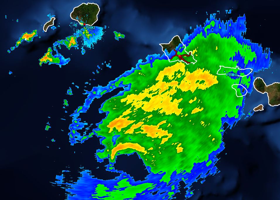
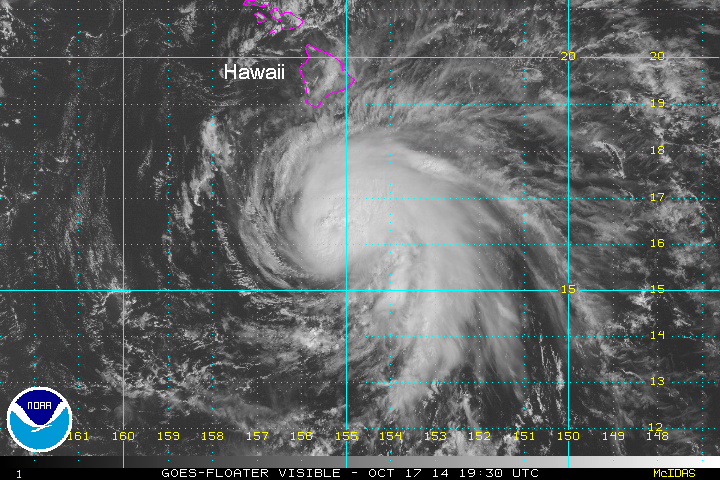
Ana remains south of the Islands, but is close enough to bring heavy rain and storms across the Islands. Hilo had over three inches of rainfall.

Current Tropical Weather
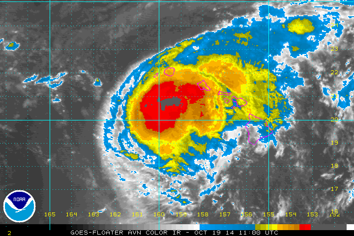
As of 2 PM HST / 8 PM EDT Hurricane Ana was centered at 19.6 N / 158.9 W or about 140 miles SSW of Honolulu, Hawaii. It was moving NW at about 10 mph. Top sustained winds are estimated at 80 mph. Pressure was estimated at 989 mb.

Tropical Weather Forecast:
Ana will be south of the western part of the Islands tonight.

Tropicast: Pacific IR Satellite
Image

Tropicast: Hawaii Radar 230 PM HST
Image
Rich Johnson
Twitter: https://twitter.com/richjohnsonwx
Certified Broadcast Meteorologist - Hurricane Expert
User avatar
Tropical Inspector
Site Admin
Site Admin
Posts: 3630
Joined: Tue Feb 20, 2007 2:28 pm
Antispam: no
Location: Under a palm tree
Contact:

Re: Ana

Post by Tropical Inspector »

Sunday Morning Update

Ana passing south of Kauai

The Weather Situation
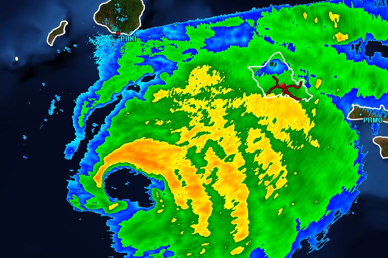
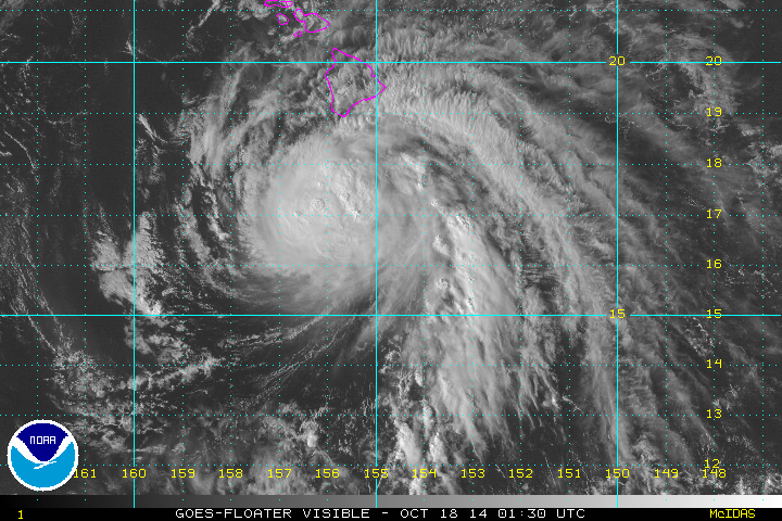
Ana is currently bringing heavy showers to the western Hawaiian Islands, especially Kauai. Weather across Hawaii will start to improve during Sunday.

Current Tropical Weather
As of 1 AM HST / 7 AM EDT Hurricane Ana was centered at 20.5 N / 159.6 W or about 105 miles south of Lihue, Hawaii. It was moving NW at about 7 mph. Top sustained winds are estimated at 80 mph. Pressure was estimated at 989 mb.

Tropical Weather Forecast:
Ana will be moving west of Kauai Sunday. This will be the last update.

Tropicast: Pacific IR Satellite
Image

Tropicast: Hawaii Radar 1:45 AM HST
Image
Rich Johnson
Twitter: https://twitter.com/richjohnsonwx
Certified Broadcast Meteorologist - Hurricane Expert
Post Reply

Return to “2014 Eastern / Central Pacific Season Archives”

Who is online

Users browsing this forum: No registered users and 0 guests