Ophelia
- Tropical Inspector
- Site Admin
- Posts: 3691
- Joined: Tue Feb 20, 2007 2:28 pm
- Antispam: no
- Location: Under a palm tree
- Contact:
Ophelia
Monday Morning Update
New tropical depression forming in deep tropics
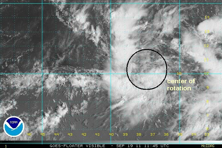
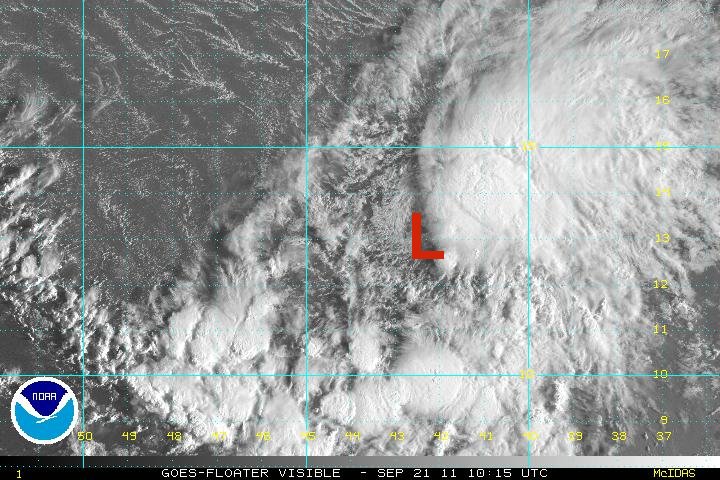
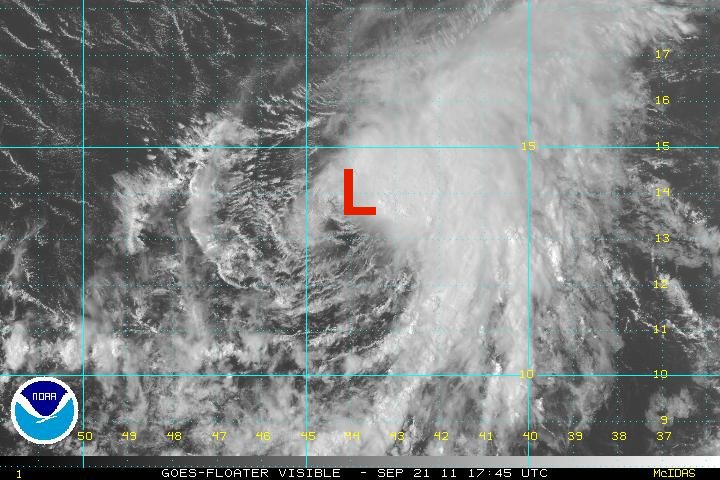
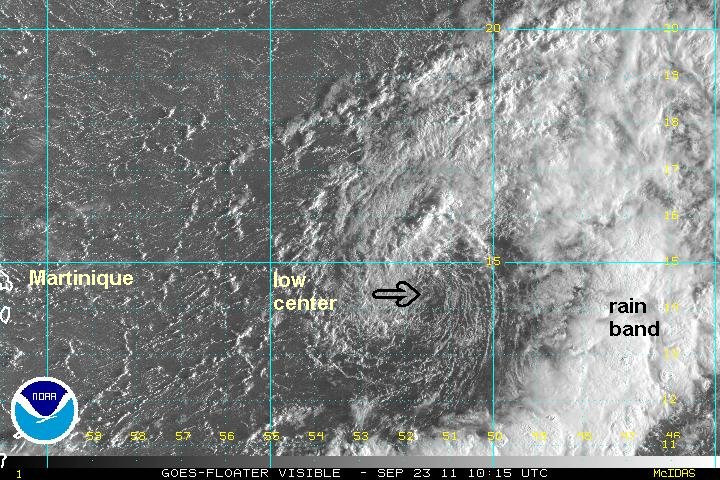
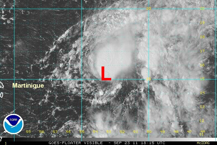
A broad low pressure area is forming well over 1000 miles east of the Lesser Antilles. Deep conveciton is associated with the tropical disturbance. Rotation is also noted at a few different locations indicating a surface and mid level rotation or a broad surface low. This tropical disturbance has a good chance of becoming a tropical depression.
At 9 am edt / ast the disturbance was centered at 10.5 N / 37.5 W or about 1400 east of the Lesser Antilles. Top sustained winds estimated at 25 mph. Movement: west 13 mph. Pressure estimated at 1008 mb.
Forecast:
Forecasts take the disturbance generally west northwest over the next several days. This will take it into or a little north of the Leeward islands. Remember, this is an early forecast and subject to significant errors.
Interests in the Lesser Antilles should follow the progress of this tropical disturbance.
Tropicast: Visible Satellite
Rich Johnson
Twitter: https://twitter.com/richjohnsonwx
Certified Broadcast Meteorologist - Hurricane Expert
Twitter: https://twitter.com/richjohnsonwx
Certified Broadcast Meteorologist - Hurricane Expert
- Tropical Inspector
- Site Admin
- Posts: 3691
- Joined: Tue Feb 20, 2007 2:28 pm
- Antispam: no
- Location: Under a palm tree
- Contact:
Re: New depression forming east of the Lesser Antilles
Monday Late Afternoon Update
New tropical depression forms (unofficially)
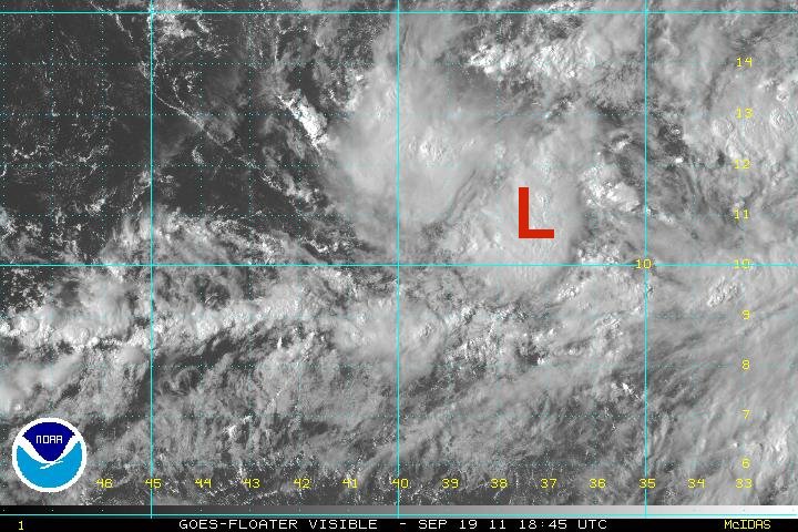
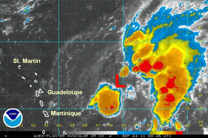
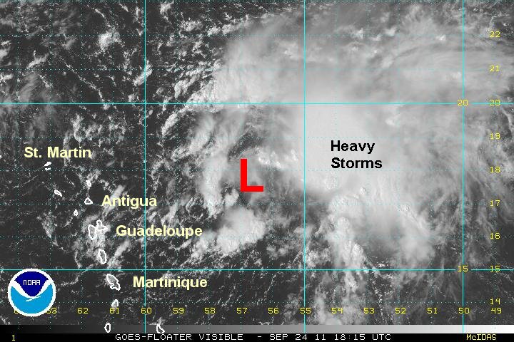
The broad area of low pressure has gained convection near the center of circulation. It appears that the disturbance is also now a close circulation so that I believe that it can be classified as the next tropical depression. The low center has been shifted a little southeast of this mornings estimate.
At 4 pm edt / ast Maria was centered at 10.7 N / 37.2 W or about 1400 east of the Lesser Antilles. Top sustained winds estimated at 25 mph. Movement: west 7 mph. Pressure estimated at 1007 mb.
Forecast:
Forecasts take the disturbance generally west northwest over the next several days. This will take it into or a little north of the Leeward islands. Remember, this is an early forecast and subject to significant errors.
Interests in the Lesser Antilles should follow the progress of this tropical disturbance.
Tropicast: Visible Satellite
Rich Johnson
Twitter: https://twitter.com/richjohnsonwx
Certified Broadcast Meteorologist - Hurricane Expert
Twitter: https://twitter.com/richjohnsonwx
Certified Broadcast Meteorologist - Hurricane Expert
- Tropical Inspector
- Site Admin
- Posts: 3691
- Joined: Tue Feb 20, 2007 2:28 pm
- Antispam: no
- Location: Under a palm tree
- Contact:
Re: New depression forming east of the Lesser Antilles
Tuesday Morning Update
Tropical system shows little movement
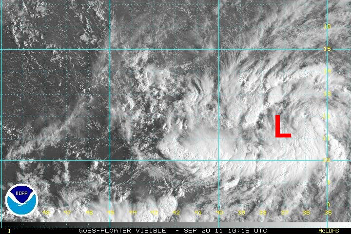
Visible satellite imagery this morning show that convection has only increased marginally. A spin is still noted and the low pressure area has shown little direction of motion for over 12 hours now. Some banding is developing on the north side of the low.
At 7 am edt / ast the tropical disturbance was centered at 11.5 N / 37.3 W or about 1450 east of the Lesser Antilles. Top sustained winds estimated at 25 mph. Movement: nearly stationary. Pressure estimated at 1007 mb.
Forecast:
Forecasts take the disturbance generally west northwest over the next several days. This will take it into or a little north of the Leeward islands...... Models show little agreement and have a large spread at this time. Remember, this is an early forecast and subject to significant errors.
Interests in the Lesser Antilles should follow the progress of this tropical disturbance.
Tropicast: Visible Satellite
Rich Johnson
Twitter: https://twitter.com/richjohnsonwx
Certified Broadcast Meteorologist - Hurricane Expert
Twitter: https://twitter.com/richjohnsonwx
Certified Broadcast Meteorologist - Hurricane Expert
- Tropical Inspector
- Site Admin
- Posts: 3691
- Joined: Tue Feb 20, 2007 2:28 pm
- Antispam: no
- Location: Under a palm tree
- Contact:
Re: New depression forming east of the Lesser Antilles
Tuesday Late Afternoon Update
Tropical "disturbance" strengthening
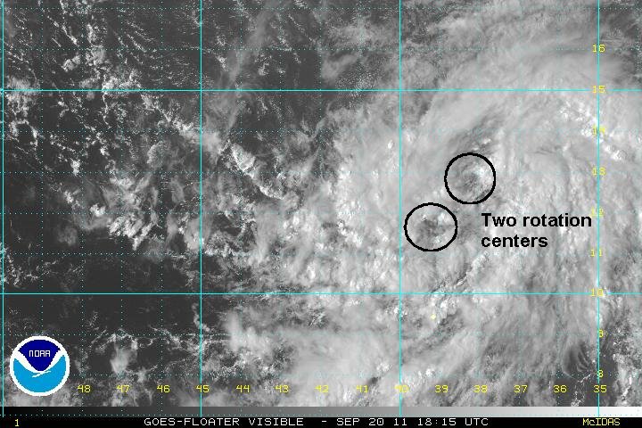
Visible satellite imagery is very interesting this afternoon. The low must be elongated. Two distinct centers are rotating and both seem to be low level centers. Deep convection continues to build and banding is improving. One of the low centers will eventually take over and the other weaken as development continues.
At 4 pm edt / ast the two low centers were centered at 11.8 N / 39.3 W and at 12.8 N 38.2 W or about 1500 miles ese of the Leeward islands. Top sustained winds estimated at 30 mph. Movement: west northwest 10 mph. Pressure estimated at 1007 mb.
Forecast:
Forecasts take the disturbance generally west northwest over the next several days. This will take it into or a little north of the Leeward islands...... Models show little agreement and have a large spread at this time. Remember, this is an early forecast and subject to significant errors.
Interests in the Lesser Antilles should follow the progress of this tropical disturbance.
Tropicast: Visible Satellite
Rich Johnson
Twitter: https://twitter.com/richjohnsonwx
Certified Broadcast Meteorologist - Hurricane Expert
Twitter: https://twitter.com/richjohnsonwx
Certified Broadcast Meteorologist - Hurricane Expert
- Tropical Inspector
- Site Admin
- Posts: 3691
- Joined: Tue Feb 20, 2007 2:28 pm
- Antispam: no
- Location: Under a palm tree
- Contact:
Re: Ophelia
wednesday Morning Update
Ophelia classified overnight
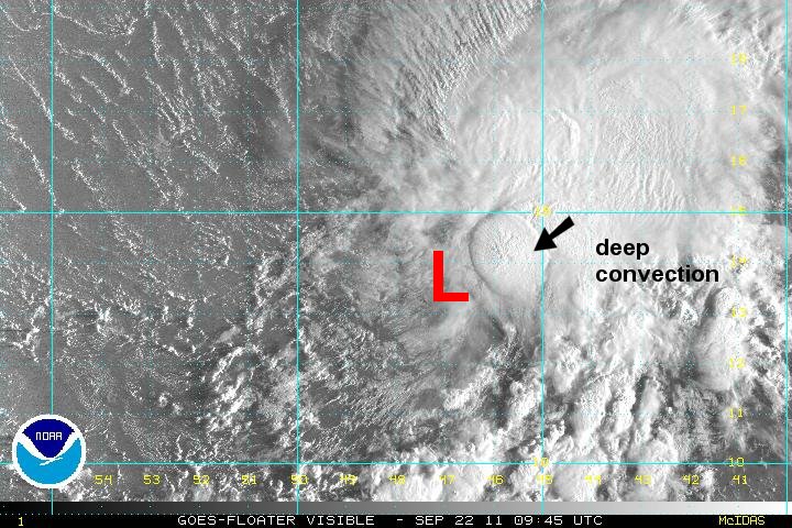
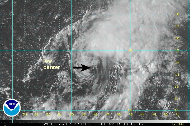
The hurricane center went from 70% chance of formation to tropical storm Ophelia last night. I not sure why they waited so long to classify this time. Anyhow, visible satellite imagery shows that the low is being sheared from the west with the low center visible on the west side of the cloud mass. Shear has relaxed a few hours ago and the low center is starting to go under the cloud mass now which should allow for some strengthening. Many tropical cyclones have had wind shear issues this year and it will be interesting to see it Ophelia is another one.
At 7 am edt / ast Ophelia was centered at 12.7 N / 41.9 W or about 1350 miles east of the Leeward islands. Top sustained winds estimated at 45 mph (NHC 45 mph last advisory). Movement: west northwest 13 mph. Pressure estimated at 1005 mb.
Forecast:
Forecasts take Ophelia west northwest toward the Leeward Islands by this weekend. .
Interests in the Lesser Antilles should follow the progress of Ophelia.
Tropicast: Visible Satellite
Rich Johnson
Twitter: https://twitter.com/richjohnsonwx
Certified Broadcast Meteorologist - Hurricane Expert
Twitter: https://twitter.com/richjohnsonwx
Certified Broadcast Meteorologist - Hurricane Expert
- Tropical Inspector
- Site Admin
- Posts: 3691
- Joined: Tue Feb 20, 2007 2:28 pm
- Antispam: no
- Location: Under a palm tree
- Contact:
Re: Ophelia
Wednesday Evening Update
Ophelia gained a little strength today
The deep convection associated with Ophelia expanded a little today. With the increase in convection, wnd speed has been adjusted up. The storm is still badly sheared with the strongest winds on the east side of the circuaation.
At 6 pm edt / ast Ophelia was centered at 13.6 N / 44.8 W or about 1150 miles east of the Leeward islands. Top sustained winds estimated at 55 mph (NHC 60 mph last advisory). Movement: west 16 mph. Pressure estimated at 1000 mb.
Forecast:
Forecasts take Ophelia west northwest toward the Leeward Islands by this weekend then recurve it well east of the Bahamas by Monday.
Interests in the Lesser Antilles should follow the progress of Ophelia.
Tropicast: Visible Satellite
Rich Johnson
Twitter: https://twitter.com/richjohnsonwx
Certified Broadcast Meteorologist - Hurricane Expert
Twitter: https://twitter.com/richjohnsonwx
Certified Broadcast Meteorologist - Hurricane Expert
- Tropical Inspector
- Site Admin
- Posts: 3691
- Joined: Tue Feb 20, 2007 2:28 pm
- Antispam: no
- Location: Under a palm tree
- Contact:
Re: Ophelia
Thursday Morning Update
Ophelia sheared / slightly stronger
At 3 am this morning (edt) Ophelia moved very close to an Atlantic buoy. The winds were sustained at 65 mph and gusted to over 75 mph - minimal hurricane force. The deep convection must be very intense on the east of the circulation since Ophelia is showing as a strongly sheared tropical storm. Wind shear is expected to continue keeping Ophelia from significantly strengthening. If the deep convection gets pushed away from the circulation, weakening will occur. Seas were measured at 25 feet at the buoy when Ophelia passed nearby.
At 7 am edt / ast Ophelia was centered at 13.4 N / 47.2 W or about 990 miles ese of the Leeward islands. Top sustained winds estimated at 65 mph (NHC 65 mph last advisory). Movement: west 14 mph. Pressure estimated at 994 mb.
Forecast:
Forecasts take Ophelia west northwest toward the Leeward Islands by this weekend then recurve it well east of the Bahamas by Monday. It may be in the vicinity of Bermuda or recurve east of Bermuda by late in the week.
Interests in the Lesser Antilles should follow the progress of Ophelia.
Tropicast: Visible Satellite
Rich Johnson
Twitter: https://twitter.com/richjohnsonwx
Certified Broadcast Meteorologist - Hurricane Expert
Twitter: https://twitter.com/richjohnsonwx
Certified Broadcast Meteorologist - Hurricane Expert
- Tropical Inspector
- Site Admin
- Posts: 3691
- Joined: Tue Feb 20, 2007 2:28 pm
- Antispam: no
- Location: Under a palm tree
- Contact:
Re: Ophelia
Thursday Late Afternoon Update
Ophelia struggling to survive.
Ophelia is struggling to survive. The low center is void of concection with the only convection removed to the northeast. The winds near the center are probably in the range of 25-35 mph. Winds will the thunderstorm cluster are probably about 45 mph with a few stronger gusts. Wind shear is winning the battle right now, but I have seen this before this season. It's too early to write Ophelia off.
At 4 pm edt / ast Ophelia was centered at 13.8 N / 48.5 W or about 950 miles ese of the Leeward islands. Top sustained winds estimated at 45 mph (NHC 65 mph 11 am edt). Movement: wnw 15 mph. Pressure estimated at 1000 mb.
Forecast:
Forecasts take Ophelia west northwest toward the Leeward Islands by this weekend then recurve it well east of the Bahamas by Monday. It may be in the vicinity of Bermuda or recurve east of Bermuda by late in the week.
Interests in the Lesser Antilles should follow the progress of Ophelia.
Tropicast: Visible Satellite
Rich Johnson
Twitter: https://twitter.com/richjohnsonwx
Certified Broadcast Meteorologist - Hurricane Expert
Twitter: https://twitter.com/richjohnsonwx
Certified Broadcast Meteorologist - Hurricane Expert
- Tropical Inspector
- Site Admin
- Posts: 3691
- Joined: Tue Feb 20, 2007 2:28 pm
- Antispam: no
- Location: Under a palm tree
- Contact:
Re: Ophelia
Friday Morning Update
Ophelia still void of convecton
Synopsis:
Ophelia changed little since yesterday afternoon in appearance. The hurricane center dropped their winds from 65 mph to 45 mph to match my estimate from the past 12 hours. They make Ophelia a depression later today. Visible satellite imagery show that the center of circulation has no convection because of strong winds aloft. It has a large and well formed low and if the wind shear were to relax in the coming days will have a chance for some recovery. Deep convection is noticed in one band well to the east of the low center.
Currently:
At 7 am edt / ast Ophelia was centered at 14.5 N / 51.1 W or about 725 miles ese of the Leeward islands. Top sustained winds estimated at 45 mph (NHC 45 mph 5 am edt). Movement: wnw 13 mph. Pressure estimated at 1004 mb.
Forecast:
Forecasts take Ophelia west northwest toward the Leeward Islands by this weekend then recurve it well east of the Bahamas by Monday. It may be in the vicinity of Bermuda or recurve east of Bermuda by late in the week.
Interests in the Lesser Antilles should follow the progress of Ophelia.
Tropicast: Visible Satellite
Rich Johnson
Twitter: https://twitter.com/richjohnsonwx
Certified Broadcast Meteorologist - Hurricane Expert
Twitter: https://twitter.com/richjohnsonwx
Certified Broadcast Meteorologist - Hurricane Expert
- Tropical Inspector
- Site Admin
- Posts: 3691
- Joined: Tue Feb 20, 2007 2:28 pm
- Antispam: no
- Location: Under a palm tree
- Contact:
Re: Ophelia
Friday Late Afternoon Update
Ophelia revives a little today
Synopsis:
Ophelia has actually gained convection and is a little stronger today. Wind shear has relaxed enough to allow the northern side of the circulation to be covered by thunderstorms.
Currently:
At 3 pm edt / ast Ophelia was centered at 15.2 N / 53.4 W or about 575 miles ese of the Leeward islands. Top sustained winds estimated at 45 mph (NHC 40 mph 11 am edt). Movement: wnw 16 mph. Pressure estimated at 1004 mb.
Forecast:
Forecasts take Ophelia west northwest toward the Leeward Islands by this weekend then recurve it well east of the Bahamas by Monday. It may be in the vicinity of Bermuda or recurve east of Bermuda by late in the week.
Interests in the Lesser Antilles should follow the progress of Ophelia.
Tropicast: Visible Satellite
Rich Johnson
Twitter: https://twitter.com/richjohnsonwx
Certified Broadcast Meteorologist - Hurricane Expert
Twitter: https://twitter.com/richjohnsonwx
Certified Broadcast Meteorologist - Hurricane Expert
- Tropical Inspector
- Site Admin
- Posts: 3691
- Joined: Tue Feb 20, 2007 2:28 pm
- Antispam: no
- Location: Under a palm tree
- Contact:
Re: Ophelia
Saturday Morning Update
Ophelia continues to fight wind shear
Synopsis:
Ophelia is once again well sheared, but still has considerable deep convection well east, and some south of the low center. Most of the effects from Ophelia will pass east of the Leewards. Only some slightly larger than normal swell will be seen on the east facing beaches and scattered, locally heavy showers this weekend.
Currently:
At 7 am edt / ast Ophelia was centered at 17.0 N / 55.3 W or about 425 miles ese of the Leeward islands. Top sustained winds estimated at 50 mph (NHC 50 mph earlier advisory). Movement: nw 14 mph. Pressure estimated at 1006 mb.
Forecast:
Forecasts take Ophelia northwest, east of the Leeward Islands this weekend then recurve it well east of the Bahamas by Monday and Tuesday where it will turn northward. It may be in the vicinity of Bermuda or recurve east of Bermuda by late in the week.
Interests in the Lesser Antilles should follow the progress of Ophelia.
Tropicast: IR Satellite
Rich Johnson
Twitter: https://twitter.com/richjohnsonwx
Certified Broadcast Meteorologist - Hurricane Expert
Twitter: https://twitter.com/richjohnsonwx
Certified Broadcast Meteorologist - Hurricane Expert
- Tropical Inspector
- Site Admin
- Posts: 3691
- Joined: Tue Feb 20, 2007 2:28 pm
- Antispam: no
- Location: Under a palm tree
- Contact:
Re: Ophelia
Saturday Late Afternooon Update
Ophelia's circulation looks weaker
Synopsis:
The low level circulation looks weaker today even though convection remains to the northeast of the low. The effects of Ophelia should remain away from the Leewards except for an occasional shower or storm. The stronger winds are not near the low center, but under the deepest convection to the northeast.
Currently:
At 4 pm edt / ast Ophelia was centered at 18.0 N / 57.0 W or about 330 miles east of St. Martin. Top sustained winds estimated at 45 mph (NHC 50 mph earlier advisory). Movement: nw 14 mph. Pressure estimated at 1006 mb.
Forecast:
Forecasts take Ophelia northwest, northeast of the Leeward Islands this weekend then recurve it well east of the Bahamas by Monday and Tuesday where it will turn northward. It may be in the vicinity of Bermuda or more likely recurve east of Bermuda by late in the week.
Interests in the Lesser Antilles should follow the progress of Ophelia.
Tropicast: Visible Satellite
Rich Johnson
Twitter: https://twitter.com/richjohnsonwx
Certified Broadcast Meteorologist - Hurricane Expert
Twitter: https://twitter.com/richjohnsonwx
Certified Broadcast Meteorologist - Hurricane Expert
- Tropical Inspector
- Site Admin
- Posts: 3691
- Joined: Tue Feb 20, 2007 2:28 pm
- Antispam: no
- Location: Under a palm tree
- Contact:
Re: Ophelia
Sunday Morning Update
Ophelia weakens into tropical depression
Synopsis:
The circulation with Ophelia that is associated with Ophelia is extremely weak. It is definitely not a tropical storm as it is being classified by NHC now. It is even a stretch to call it a tropical depression as the low is disintegrating into an open wave. The next several hours will tell the tale if it can hold on as tropical depression or disintegrates.
Currently:
At 9 am edt / ast (Ophelia) was centered at 18.2 N / 60.4 W or about 180 miles east of St. Martin. Top sustained winds estimated at 25 mph (NHC 40 mph earlier advisory). Movement: west 14 mph. Pressure estimated at 1008 mb.
Forecast:
Forecasts take Ophelia northwest, northeast of the Leeward Islands today then recurve it well east of the Bahamas by Monday and Tuesday where it will turn northward. It may be in the vicinity of Bermuda or recurve east of Bermuda by late in the week. As of this morning, if the circulation with Ophelia remains this weak the above forecast will be bogus. It will either totally disintergate or move farther west as a weak system.
Interests in the Lesser Antilles should follow the progress of Ophelia.
Tropicast: Visible Satellite
Rich Johnson
Twitter: https://twitter.com/richjohnsonwx
Certified Broadcast Meteorologist - Hurricane Expert
Twitter: https://twitter.com/richjohnsonwx
Certified Broadcast Meteorologist - Hurricane Expert
- Tropical Inspector
- Site Admin
- Posts: 3691
- Joined: Tue Feb 20, 2007 2:28 pm
- Antispam: no
- Location: Under a palm tree
- Contact:
Re: Ophelia
At 5 pm edt NHC finally agreed that Ophelia's circulation has weakened and is no longer a circulation.
Rich Johnson
Twitter: https://twitter.com/richjohnsonwx
Certified Broadcast Meteorologist - Hurricane Expert
Twitter: https://twitter.com/richjohnsonwx
Certified Broadcast Meteorologist - Hurricane Expert
- Tropical Inspector
- Site Admin
- Posts: 3691
- Joined: Tue Feb 20, 2007 2:28 pm
- Antispam: no
- Location: Under a palm tree
- Contact:
Re: Ophelia
Tuesday Evening Update
Ophelia - the sequel.....
Synopsis:
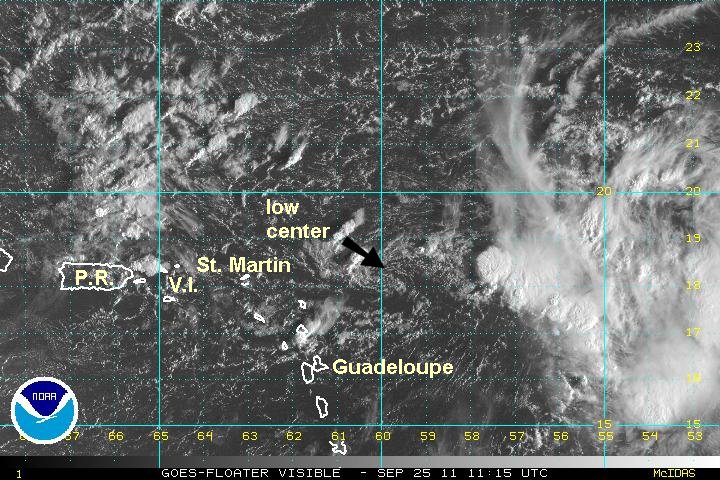
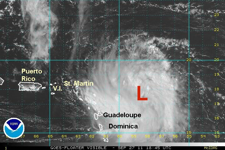
The mass of convection east of the Lesser Antilles has obviously had a circulation today. It was only a decision of whether it was a depression or tropical storm. The hurricane hunters investigated and found sustained winds of only 25 mph.
I will also say that I am not convinced that this is Ophelia. It looked like the circulation with Ophelia went in the Leewards Sunday. Some rain bands are affecting the Leewards.
Currently:
At 5 pm edt / ast Ophelia was centered at 18.0 N / 60.4 W or about 180 miles east of St. Martin. Top sustained winds estimated at 25 mph (NHC 25 mph). Movement: nw 5 mph. Pressure estimated at 1009 mb.
Forecast:
Forecasts take Ophelia north northwest east of the Lesser Antilles. It may be in the vicinity of Bermuda by the end of the week.
Interests in the Lesser Antilles should follow the progress of Ophelia.
Tropicast: Visible Satellite
Rich Johnson
Twitter: https://twitter.com/richjohnsonwx
Certified Broadcast Meteorologist - Hurricane Expert
Twitter: https://twitter.com/richjohnsonwx
Certified Broadcast Meteorologist - Hurricane Expert
Who is online
Users browsing this forum: No registered users and 0 guests