Sunday Evening Update
Tropical disturbance getting organized
The disturbance is centered near 16° N / 111° W or a little less than 500 miles south of Cabo San Lucas and a little less than 500 miles southwest of Manzanillo.
A new tropical disturbance is about to reach tropical depression stage. The disturbance is showing increased banding and it appears that a closed low has just about formed. The convection around the center of circulation has also increased and we estimate that this will be a depression soon. The disturbance is moving west northwest away from Mexico and effects will be minimal.
Tropicast: Pacific Floater Visible Satellite
Blanca
- Tropical Inspector
- Site Admin
- Posts: 3628
- Joined: Tue Feb 20, 2007 2:28 pm
- Antispam: no
- Location: Under a palm tree
- Contact:
Blanca
Rich Johnson
Twitter: https://twitter.com/richjohnsonwx
Certified Broadcast Meteorologist - Hurricane Expert
Twitter: https://twitter.com/richjohnsonwx
Certified Broadcast Meteorologist - Hurricane Expert
- Tropical Inspector
- Site Admin
- Posts: 3628
- Joined: Tue Feb 20, 2007 2:28 pm
- Antispam: no
- Location: Under a palm tree
- Contact:
Re: New Tropical depression forming south of Cabo San Lucas
Monday Morning Update
Tropical disturbance should be classified soon
The tropical disturbance is centered about 450 miles south southwest of Cabo San Lucas and moving west northwest away from Mexico.....effects will be minimal.
Satellite imagery shows a large area of convection near the center of circulation and excellent outflow on the eastern side of the circulation. Quickscat indicates a closed surface low with wind estimates of 40 knots. This system in our opinion, is a tropical depression. It has a good chance of officially being classified as the second tropical storm of the eastern Pacific season later today. ( It appears to be close to storm strength now. )
Advisories from NHC will likely be started at 8 am pdt.
Tropicast: Pacific Floater I.R. Satellite
Rich Johnson
Twitter: https://twitter.com/richjohnsonwx
Certified Broadcast Meteorologist - Hurricane Expert
Twitter: https://twitter.com/richjohnsonwx
Certified Broadcast Meteorologist - Hurricane Expert
- Tropical Inspector
- Site Admin
- Posts: 3628
- Joined: Tue Feb 20, 2007 2:28 pm
- Antispam: no
- Location: Under a palm tree
- Contact:
Re: Blanca
Monday Late Morning Update
Tropical storm Blanca classified
NHC decided to go straight to ts strength which was a good move.....
Tropical storm Blanca classified
NHC decided to go straight to ts strength which was a good move.....
Rich Johnson
Twitter: https://twitter.com/richjohnsonwx
Certified Broadcast Meteorologist - Hurricane Expert
Twitter: https://twitter.com/richjohnsonwx
Certified Broadcast Meteorologist - Hurricane Expert
- Tropical Inspector
- Site Admin
- Posts: 3628
- Joined: Tue Feb 20, 2007 2:28 pm
- Antispam: no
- Location: Under a palm tree
- Contact:
Re: Blanca
Monday Afternoon Update
Tropical storm Blanca slowly organizes
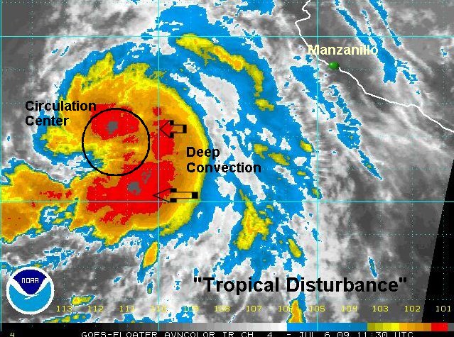
As of 3:45 pm edt (12:45 pm pdt ) Balanca is centered near 17.8 N / 112.8 W or about 390 miles south southwest of Cabo San Lucas. Movement was wnw at about 10 mph. NHC estimated top sustained winds of 45 mph on the earlier advisory. Even though the very deep convection burst over the center of circulation has waned, satellite imagery looks to support about 50 mph top sustained surface winds now.
This tropical feature poses little threat to Mexico. Rain bands are offshore and movement is away from land. The only noticable effects will be higher than normal swell on the southern Baja and western Mexico.
Tropicast: Pacific Floater Visible Satellite
Rich Johnson
Twitter: https://twitter.com/richjohnsonwx
Certified Broadcast Meteorologist - Hurricane Expert
Twitter: https://twitter.com/richjohnsonwx
Certified Broadcast Meteorologist - Hurricane Expert
- Tropical Inspector
- Site Admin
- Posts: 3628
- Joined: Tue Feb 20, 2007 2:28 pm
- Antispam: no
- Location: Under a palm tree
- Contact:
Re: Blanca
Monday Evening Update
Tropical storm Blanca not changing much
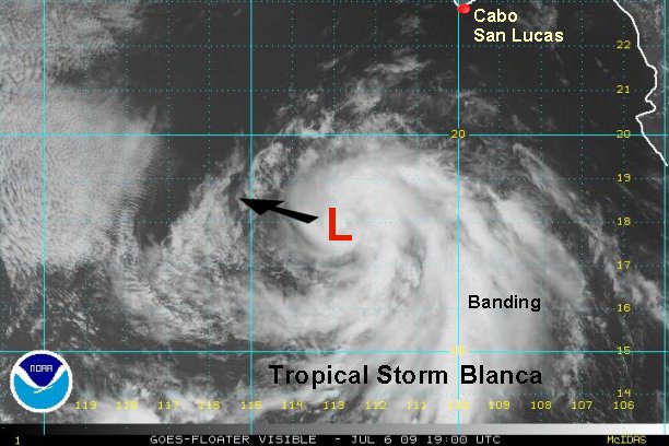
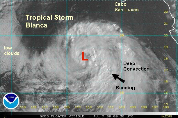
As of 9:30 pm edt ( 6:30 pm pdt ) tropical storm Blanca is centered near 18.0 N / 113.8 W or about 415 miles south southwest of Cabo San Lucas. Top sustained winds are estimated near 45 mph.
I.R. satellite imagery shows cloud top warming near the center of circulation. Because of this we are lowering the winds to 45 mph from 50 mph. Outflow has improved aloft all sectors and is excellent on the eastern side of the storm.
Blanca is moving just north of due west. This will move it over cooler water shortly which should inhibit much strengthening. In fact look for weakening as it moves over the cooler water in 12-24 hours.
Blanca is not a threat to Mexico.
Tropicast: Pacific Floater Visible Satellite
Rich Johnson
Twitter: https://twitter.com/richjohnsonwx
Certified Broadcast Meteorologist - Hurricane Expert
Twitter: https://twitter.com/richjohnsonwx
Certified Broadcast Meteorologist - Hurricane Expert
- Tropical Inspector
- Site Admin
- Posts: 3628
- Joined: Tue Feb 20, 2007 2:28 pm
- Antispam: no
- Location: Under a palm tree
- Contact:
Re: Blanca
Tuesday Morning Update
Tropical storm Blanca moving out to sea, will weaken soon
At 8 am edt ( 5 am pdt ) tropical storm Blanca is centered near 18.6 N / 115.3 W or about 440 miles southwest of Cabo San Lucas. It is moving west north west at about 12 mph. Top sustained winds are officially 50 mph. We will estimate 45 mph at this time with a deteriorating appearance around the circulation center. There is on solid band on the east side that may have some gusts to 50 mph. Unfortunately, no quickscat is available to help with the estimate. It is amazing how many times the satellite "misses" the zone on interest. Better luck next time.
Blanca is heading toward cooler water and will start to weaken soon - in the next 12-24 hours.
Blanca is not a threat to Mexico.
Tropicast: Pacific Floater I.R. Satellite
Rich Johnson
Twitter: https://twitter.com/richjohnsonwx
Certified Broadcast Meteorologist - Hurricane Expert
Twitter: https://twitter.com/richjohnsonwx
Certified Broadcast Meteorologist - Hurricane Expert
- Tropical Inspector
- Site Admin
- Posts: 3628
- Joined: Tue Feb 20, 2007 2:28 pm
- Antispam: no
- Location: Under a palm tree
- Contact:
Re: Blanca
Tuesday Afternoon Update
Tropical storm Blanca quickly fading away
At 2:30 pm edt ( 11:30 pm pdt ) Blanca was centered near 19.6° N / 116.5° W or about 475 miles southwest of Cabo San Lucas. It is now moving northwest at about 11 mph.
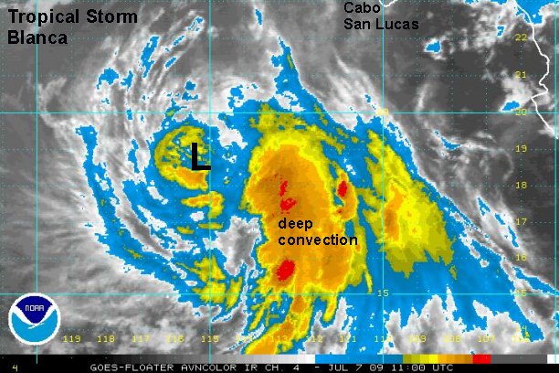
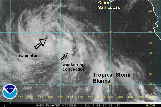
Blanca is moving over cooler water and rapidly losing strength. At last advisory, NHC had estimated 45 mph. We now think that top sustianed surface winds are about 35 mph and no longer a tropical storm. The center of circulation is now plainly visible as shearing has pushed the convection away. The convection that remains is weakening as evidenced by the cold top warming.
This will be our last update on Blanca.
Tropicast: Pacific Floater I.R. Visible Satellite
Rich Johnson
Twitter: https://twitter.com/richjohnsonwx
Certified Broadcast Meteorologist - Hurricane Expert
Twitter: https://twitter.com/richjohnsonwx
Certified Broadcast Meteorologist - Hurricane Expert
Who is online
Users browsing this forum: No registered users and 0 guests