|
|
Hurricane pictures / summaries 2020
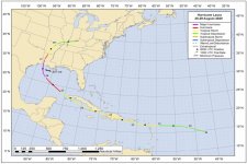
Satellite images provided by NOAA. Hurricane tracks courtesy of the National Hurricane Center.
 Click pictures for close up view Click pictures for close up view
|
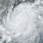
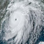
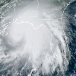
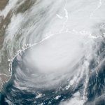
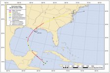
Hurricane Hanna
July 25, 2020
Tropical depression 8 formed in the central Gulf of Mexico on July 23rd. It drifted west and slowly developed into a hurricane just before landfall over south Texas on the afternoon of the 25th. It moved in over Padre Island NNE of Brownsville. Heavy rainfall was the main hazard with more that a foot of rainfall produced over parts of south Texas. Most winds reported inland were under hurricane strength.
|

|
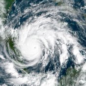
Hurricane Isaias
July 31, 2020
Isaias will be remembered for its legacy of widespread power outages in the northeastern U.S. It began as a distrubance at a low latitude east of the Windward Islands. The low pressure had a hard time organizing through the eastern Caribbean. Despite this it brought heavy rainfall to Puerto Rico and and Dominican Republic. It crossed into the southwestern Bahamas and became a hurricane. Isaias stayed east of Florida with very ittle impacts.
After weakening, Isaias became a hurricane just before landfall over extreme southeastern North Carolina on the evening of the 23rd. No sustained winds of hurricane force were seen on land. It paralleled the coast northward bringing flooding rainfall to the Mid-Atlantic coastal areas with totals of over 6". Winds picked up near New York City as the system tapped jet stream winds. Some gusts were over hurricane force.
|

|
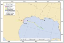
Hurricane Marco
August 23, 2020
Tropical Depression 14 formed half way between Central America and Jamaica on the 20th of August/ 20th. it moved through the Yucatan Channel as tropical storm Marco and briefly became a hurricane in the central Gulf. Wind Shear ripped up the circulation as it greatly weakened before a brief landfall near extreme southeastern Louisiana.
|
|
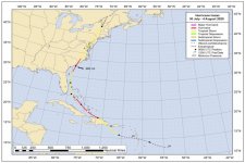
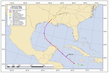
Hurricane Laura
August 26, 2020
Tropical depression 13 was classified well east of the Leeward Islands. It was classified as tropical storm Laura just as it was entering into the Leewards. It continued westward moving south of forecast guidance over all of the northern Antilles bringing flooding rainfall. Laura became a hurricane after moving northwest of western Cuba. It rapidly deepened as it moved from the central Caribbean to the coast of southwestern Louisiana where it make landfall as a category four hurricane. Wind damage occurred well inland over western Louisiana.
|
|
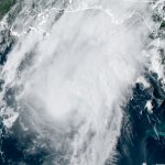
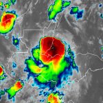
Hurricane Nana
September 3, 2020
On September 1st Tropical Storm Nana was classified from a persistant area of unsettled weather southwest of Jamaica. It moved due west north of Honduras and made landfall in Belize just after midnight on the morning of the third. It was classified as a hurricane just before landfall. It's pressure was very high at 993 mb to be classified as a hurricane.
|

|
Hurricane Paulette
September 13, 2020
Paulette formed from a disturbance in the eastern Atlantic. After strengthening into a storm windshear weakened it. It moved into an area of light windshear and strengthened as it moved over Bermuda, making a direct hit as a category 1 hurricane. It strengthened further into a cat 2 as it moved rapidly northeast into northern north Atlantic.
|
|
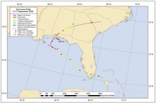
Hurricane Sally
September 14, 2020
Tropical depression 19 was classified just east of south Florida. It brought heavy rainfall to the Keys as it moved west into the southeastern Gulf. Sally became a tropical storm and started to rapidly deepen as it approached southeast Louisiana. Wind shear and some dry air interupted develpment and forward speed stalled allowing for it to nearly stall before landfall. This effectively shifted the track eastward toward the coast of Alabama.
|

|
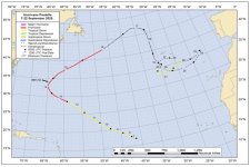
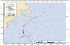
Hurricane Teddy
September 19, 2020
Teddy was classified as a tropical depression on September 12 and slowly organized in the deep tropics as it fought wind shear. It was declared a hurricane on the 16th as it moved northwest toward Bermuda. It became a major hurricane but started to be affected by wind shear shortly thereafter. It passed to the east of Bermuda with the weak side of the hurricane passing over. High surf affected the U.S. east coast as Teddy took aim on Nova Scotia. It became an extratropical cyclone as it passed into eastern Canada.
|
|
Hurricane Delta
October 9, 2020
Delta developed from a disturbance in the central Caribbean. It went through a rapid intensification period south of Jamaica but weakened considerably just before making landfall on the Yucatan peninsula north of Cozumel. It restrengthened over the western Gulf of Mexico and topped out at 120 mph. Delta made landfall on the Louisiana coast just a few miles east of where Hurricane Laura moved inland just weeks before. Rainfall amounts of 10"+ fell over Louisiana and 8"+ over north Georgia.
|

|
Hurricane Epsilon
October 21, 2020
Epsilon formed in the middle of the northern Atlantic Ocean from a cold upper air low. It eventually took on tropical characteristics and rapidly intensified. It was an unusual tropical cyclone with a small CDO but large circulation. It passed almost 200 miles east of Bermuda on the evening of the 22nd. Some tropical storm force wind gusts were seen over Bermuda.
|
|
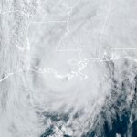
Hurricane Zeta
October 28, 2020
Zeta formed from a disturbance in the western Caribbean. It strengthened to near minimal hurricane strength as it crossed the Yucatan peninsula. After briefly weakening, it regained strength and made landfall on the southeast Louisiana coast at 110 mph. The top wind gust recorded was 112 mph. It picked up speed and brought significant wind damage over parts of Alabama into North Georgia including the Atlanta metro area.
|
|
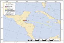
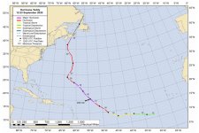
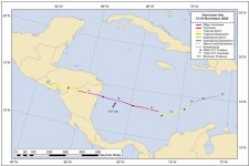
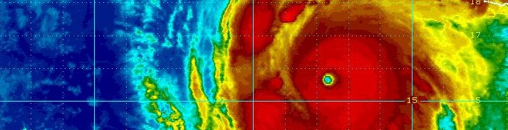
Hurricane Iota
November 16, 2020
Hurricane Iota will be remembered as a late season hurricane that brought devestation to northern Nicaragua and other parts of Central America. Iota began organizing south of Hispaniola on the 13th and started to rapidly strengthen. It made landfall on the evening of the 16th on the northeast coast of Nicaragua as a category 5, 160 mph hurricane. Widespread destruction occured from wind damage, flooding, surge and mudslides.
|
Hurricane pictures and summaries main page.
|
|
|
)
)
)
)
)
)
)
)
)
)
)
)
)
)
)
)
)
)
)
)
)
)
)
)