|
|
Hurricane pictures / summaries 2019
Satellite images provided by NOAA. Hurricane tracks courtesy of the National Hurricane Center.
 Click pictures for close up view Click pictures for close up view
|
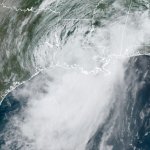
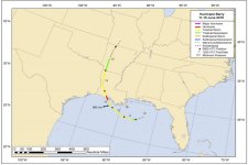
Hurricane Barry
July 13, 2019
Barry formed from a mid latitude weather complex that moved from the central U.S. through Georiga then into the Gulf of Mexico. It then moved westward and gained tropical characteristics. It's low level circulation was not well defined and it made landfall into Louisiana with a very nondiscript eyewall. It was declared a hurricane for a few hours off the coast and was downgraded to a tropical storm just before landfall. It's possible it was never a hurricane.
|
|
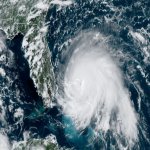
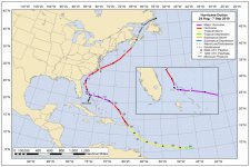
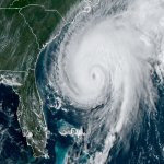
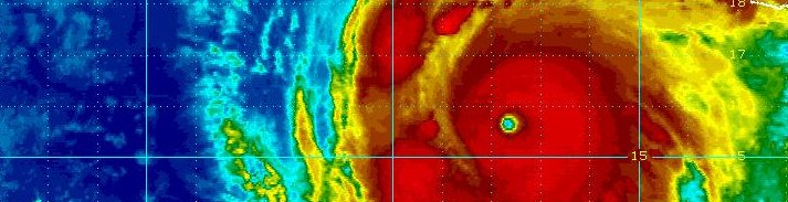
Hurricane Dorian
September 2, 2019
Dorian formed east of the Lesser Antillies and slowly strengthened as it moved toward the Caribbean Sea. It turned northwestward inbetween Puerto Rico and the Virgin Islands. It became a hurricane on August 28th just northeast of the eastern Puerto Rico. A ridge of high pressure to the north forced Dorian westward as it began a rapid deepening phase. It made landfall on the northeast Bahamas on September 1st at 185 mph, tying it as ithe strongest landfalling hurricane in the Atlantic. It then drifted over Grand Bahama Island before turning northward. It caused catastrophic damage over the northern Bahamas, making it their worst natural disaster. Dorian moved very close to the U.S. coast from Florida to South Carolina as it weakened. It made another landfall over Cape Hatteras on September 6th with wind speeds of 90 mph. Days later it crossed into Nova Scotia as an extratropical cyclone.
|
|
Hurricane Humberto
September 17, 2019
Humberto formed just east of the northern Bahamas on September 14th. It moved northward well east of the U.S. coast as it strengthened. It reached a top sustained surface wind of 125 mph west of Bermuda. It passed northwest of Bermuda on the afternoon of the 18th and became extratropical the following day.
|
|
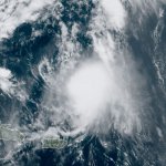
Hurricane Jerry
September 19, 2019
Jerry formed well east of the Lesser Antilles in the deep tropics. It was interesting to see a large amount of African dust move just north around the circulation of Jerry. Jerry brushed the Windwards with some rainfall, but the storm's worst effects remained out to sea. It strengthened to 80 mph north of the Windwards before being sheared, staying well east of the U.S. east coast.
|

|
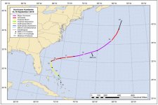
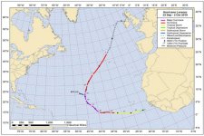
Hurricane Lorenzo
September 26, 2019
Lorenzo formed south of the Cabo Verde Islands and rapidly strengthened as it moved into the open North Atlantic waters well northwest of the islands. It became the 2nd category 5 hurricane of the season with top sustained winds of 160 mph. It was also the easternmost category 5 hurricane on record. Before becomng extratropical, and weakening it brushed the western Azores. Wind gusts to near 100 mph were recorded.
|
|
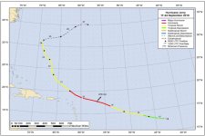
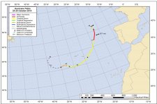
Hurricane Pablo
October 27, 2019
Hurricane Pablo was classified as a minimal hurricane at 80 mph northeast of the Azores and southwest of Ireland. It was located in the cold core sector of a much larger low pressure system. It was over 20 degree C water temperatures which is extremely rare.
|
Hurricane pictures and summaries main page.
|
|
|
)
)
)
)
)
)
)
)
)
)
)
)