|
|
Hurricane pictures / summaries 2014
Satellite images provided by NOAA / NASA / MODIS. Hurricane tracks courtesy of the National Hurricane Center.
 Click pictures for close up view Click pictures for close up view
|
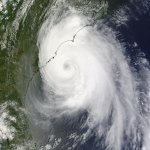
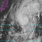
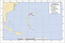
Hurricane Arthur
July 3, 2014
Arthur was upgraded to a tropical storm east of the east central Florida coast on July 1. It was fighting northerly wind shear which had slowed development for a few days. By late evening Tuesday, wind shear had weakened and a large comma shaped cluster of storms was developing near the circulation center. This brought heavy rainfall to the northwestern Bahamas. By Wednesday afternoon, an eye shaped structure was evident about 100 miles northeast of Cape Canaveral, Florida. Winds had increased to 65 mph.
Arthur picked up forward speed overnight and strengthened into a hurricane at 80 mph. Thursday afternoon the eye of the hurricane was about 100 miles east of Charleston, SC. Top sustained winds had increased to 90 mph. Seas were in the range of 20-25 feet offshore. By late evening Arthur turned more northeast and The Hurricane Center increased winds to 100 mph. The strongest measured gusts were found at Ft. Macon at 87 mph at approximately the time the eye passed over Cape Lookout, NC.
Arthur began to accelerate up the coast. Friday morning is was east of the Virginia Capes, Friday evening southeast of Cape Cod and Saturday morning up the Bay of Fundy. Several inches of rainfall stretched along the Mid-Atlantic to New England coast west of the track from Arthur.
|
|
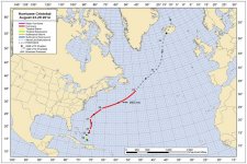
Hurricane Bertha
August 4, 2014
Bertha was classified directly as a tropical storm 275 miles east of Barbados. A hurricane hunter plane investigated the structure of the system and found 45 mph winds. Upper air winds the next day on August 1st had strengthened and sheared the structure. It turned more northwest and passed between Dominica and Martinique with little problem from wind or rainfall. The storm passed south of Puerto Rico Saturday and over the extreme eastern part of the Dominican Republic that evening. Heavy rainfall was seen over the Virgin Islands, Puerto Rico and the Dominican Republic. Bertha's circulation was greatly disrupted from interaction with land.
By later Sunday the circulation was reorganizing east of the southeastern Bahamas. Bertha officially reached hurricane strength Monday morning east of the northern Bahamas at 80 mph. Wind shear quickly redeveloped and once again weakened the structure as it moved east of the Southeastern U.S. coast.
|
|
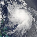
Hurricane Christobal
August 27, 2014
A disturbance near the Turks and Caicos was classified as tropical depression 4 on the evening of August 23rd. It had already brought heavy rainfall to Puerto Rico and Hispaniola. It was upgraded to a tropical storm the next morning as heavy rain fell over the Turks and Caicos and southeastern Bahamas. Wind shear picked up soon after, but Christobal continued to produce rainfall amounts over ten inches in this same area. It slowly moved northeast away from the Bahamas and strengthened into a hurricane. Top sustained winds were estimated at 80 mph Wednesday morning. Christobal accelerated offshore of the U.S. east coast and became extratropical was it moved toward the north Atlantic ocean
|

|
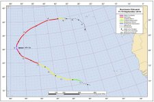
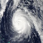
Hurricane Edouard
September 14, 2014
On September 11th, a tropical wave that was followed from the coast of Africa was classified as a tropical depression in the deep tropics. The next day it was upgraded to tropical storm Edouard. This tropical cyclone was never a threat to land as it moved in a northwest direction well to the northeast of the Lesser Antilles. It appeared to become a hurricane on the morning of the 14th as a well defined eye appeared. It officially became the 4th hurricane of the season that afternoon. Edouard continued strengthening Monday with a classic looking eye. It was upgraded to the season's first major hurricane the following morning. Edouard gradually turned northeast, then east toward the Azores. It lost its strength and tropical characteristics over colder water before reaching the Azores a few days later
|
|
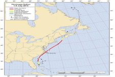
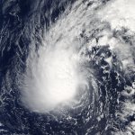
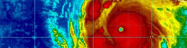
Hurricane Fay
October 11, 2014
Fay was the product of an upper air low pressure system. An upper air low sat for several days north of the Leeward Islands. The system gradually strengthened and was classified a subtropical storm on the evening of the 7th. Despite strong southeasterly wind shear, Fay continued to display deep convection on the northwest side of the circulation. Fay gradually became fully tropical as it moved over the water Atlantic waters south of Bermuda. On the morning of the 12th, Fay passed over Bermuda before daybreak. Winds were sustained at 61 MPH, with gusts to 82 MPH at the weather service. A twitter report from Smith's Parrish at 140 ft elevation relayed an unofficial wind of 81 MPH with a gust to 109 MPH. Fay rapidly moved away from Bermuda during the day. The Hurricane Center classified Fay as a minimal hurricane at 5 PM on the 12th from a satellite estimate jsust before becoming extratropical. The image above is from tropical storm Fay.
|
|
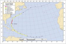
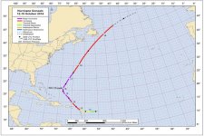
Hurricane Gonzalo
October 15, 2014
Gonzalo formed from a tropical disturbance several hundred miles east of the Leeward Islands. A well defined circulation became evident along with deep convection near the center of circulation. The tropical disturbance was upgraded straight to a minimal tropical storm Sunday afternoon of the 12th. It passed over Antigua on the morning of the 13th and moved northwest over St. Martin and Anquilla later that evening as a hurricane. The airport at St. Martin reported a gust to 64 mph. Gonzalo began to increase in strength as it pulled away from the northeast Caribbean and as wind shear relaxed. It became a major hurricane on the 14th and a category 4 hurricane at 130 mph at 11 am edt on the 15th. The course keep it safely east of the Bahamas and Turks and Caicos.
Gonzalo went through a few eyewall replacement cycles allowing for some fluctuation in wind speed. It topped out at 145 mph on Thursday as it was turing to approach Bermuda. The hurricane began to lose strength as it neared Bermuda and dropped down to 110 mph or a strong category two hurricane. Gonzalo passed directly over Bermuda late in the evening. Winds were reported at 98 mph with gusts to 134 mph on Commissioner's point at an elevated location. The hurricane accelerated into the north Atlantic and passed just east of Newfoundland early Sunday morning
|
Hurricane pictures and summaries main page.
|
|
|
)
)
)
)
)
)
)
)
)
)
)
)