|
|
Hurricane pictures / summaries 2012
Satellite images provided by NOAA / NASA / MODIS. Hurricane tracks courtesy of the National Hurricane Center.
 Click pictures for close up view Click pictures for close up view
|
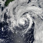
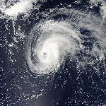
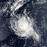
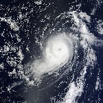
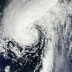
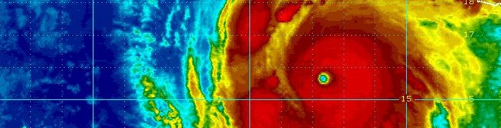
Hurricane Chris
June 19, 2012
Chris is noted as the farthest north forming tropical cyclone during the month of June from the satellite era. Chris originally was a low pressure system associated with a cold front south of Bermuda. It was classified as a subtropical storm as it moved well north of Bermuda. Convection began to form near the center of circulation and the transition to tropical storm was finalized on the morning of the 19th. Chris briefly became a minimal hurricane on the morning of the 21st. It's peak intensity of 85 mph / 974 mb was obtained from a number of satellite estimates. There were no deaths or damage reports from Chris. Only two other tropical cyclones were recorded as developing north of 35 degrees latitude during the month of June.
|
|
Hurricane Ernesto
August 7, 2012
Ernesto became a hurricane shortly before making landfall on the coast of the Mexican Yucatan. It formed from a tropical wave that moved off of the African coast during late July. By August 1, a tropical depression developed about half way between the African coast and the Lesser Antilles. Upper air wind shear and dry air prevented strengthening until just east of the Lesser Antilles where it became a minimal tropical storm. As Ernesto approached the western Caribbean, a more favorable environment for development was encountered. It rapidly organized into a hurricane just before landfall at Cayo Norte, and a few hours later at Majahual on the evening of August 7th. Ernesto weakened over the Yucatan peninsula but briefly moved into the Bay of Campeche where again it made a third landfall as it moved inland and dissipated.
The estimated top sustained winds were 100 mph at the time of landfall. This is where the lowest pressure of 973 mb was measured. The strongest winds in the Lesser Antilles were measured at 65 mph at St. Lucia.
|
|
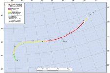
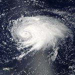
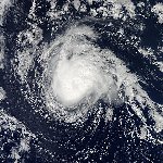
Hurricane Gordon
August 18, 2012
Gordon formed from a tropical wave from Africa. It was classified as a tropical depression on the morning of August 15, 600 nautical miles southeast of Bermuda. Gordon recurved around the Bermuda-Azores high and strengthened to a strong category 2 hurricane at 110 mph (965 mb). It weakened as it continued toward the Azores where power outages and minor storm damage was noted. Santa Maria island reported a wind gust to 80 mph in the southeastern Azores on the morning of the 20th. There were no casualties associated with Gordon.
|
|
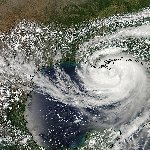
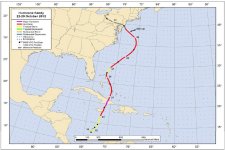
Hurricane Isaac
August 28, 2012
Isaac originated from an African tropical wave. It was classififed as a tropical depression 625 miles east of the Lesser Antilles. Isaac strengthened into a tropical storm by the 22nd and quickly moved west and passed inbetween Dominica and Guadeloupe. Isaac remained as a tropical storm for most of its lifetime. It continued west northwest across the northern Caribbean islands and turned northwest into the Gulf of Mexico. It briefly became a category 1 hurricane at 80 mph (965 mb) before making landfall in southeast Louisiana on the evening of the 29th.
A top storm tide of 13.5 feet was recorded in Plaquemines Parrish, LA with additional unofficial tides up to 17 feet. Storm tides up to 9 feet were measured on the Mississippi coast. A large area of more than 10 inches of rainfall was measured over eastern Louisiana and southern Mississippi with a maximum of 26.71" at Pascagoula, MS. Isaac produced 17 tornadoes. Thirty-four deaths were also attributed directly to Isaac in Haiti, The Dominican Republic and United States
|
|
Hurricane Kirk
August 31, 2012
Kirk was a category 2 hurricane that remained over the central and northern North Atlantic Ocean during its lifetime. It formed from a tropical wave from Africa and strengthened into a 105 mph hurricane on the 31st with the lowest estimated pressure at 970 mb. There were no damage or casulaties associated with Kirk.
|
|
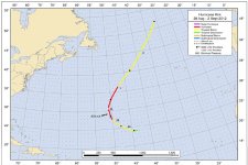
Hurricane Leslie
September 5, 2012
Leslie had a similar but slightly farther west track than its predecessor Hurricane Kirk. Leslie formed from an African tropical wave and was classified as a tropical depression on the evening of the 29th. It strengthened into a tropical storm and recurved to remain northeast of the Leeward Islands. Leslie then came under the influence of a ridge of high pressure to its north slowing its motion for several days. Cold upwelled waters from Kirk precluded Leslie's development into a hurricane as it neared Bermuda. After passing Bermuda a strong upper air trough increased the forward speed of Leslie to approximately 40 mph. Leslie continued nne and made landfall in eastern Newfoundland.
Leslie had strengthened into an 80 mph hurricane (968 mb). Rainfall totals of 2-4 inches were recorded on Newfoundland with a maximum total of 6.5". Power outages were reported on Bermuda and Newfoundland. Additional damage was reported to houses and trees especially on the Avalon Peninsula of Newfoundland.
|
|
Hurricane Michael
September 7, 2012
Michael spent its entire lifetime in the open waters of the central North Atlantic Ocean. Michael formed from a non-tropical upper air low pressure system. It became only the 5th major hurricane to develop from a non tropical disturbance. At its peak intensity, winds were estimated at 115 mph with a minimum pressure of 964mb. There were no damage or casulties from Michae.
|
|
Hurricane Nadine
September 28 2012
Nadine was noted for attaining hurricane strength two seperate times - a record thirteen days apart. It also made three complete loops south of the Azores. Nadine formed from a tropical wave west of Africa. It recurved northeast and then encountered a variety of upper air wind patterns which caused the looping pattern. Nadine reached a peak intensity of 90 mph with a minimuum pressure of 978 mb. There were no damage or casualties with Nadine.
|
|
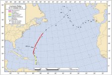
Hurricane Rafael
October 17, 2012
Rafael formed as a tropical storm in the northeastern Caribbean and moved north across the Leeward Islands on the evening of the 13th. Rafael became a hurricane well south of Bermuda with a peak intensity of 90 mph (969 mb). The strongest winds in the Caribbean were reported at Barbados with a gust to 41 mph. There was one death from Rafael on Guadeloupe. During its extratropical lifetime, Rafael continued into the extreme northern North Atlantic Ocean. It looped around a low pressure area and moved southeast where it eventually dissipated over Portugal.
|
|
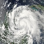
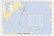
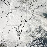
Hurricane Sandy
October 28, 2012
Sandy will be remembered for the loss of lives and large amount of damage inflicted upon the Northeastern U.S. coast. Sandy developed in the southwestern Caribbean Sea and moved north. It first made landfall on the eastern coast of Jamaica then made a second landfall on the southeastern coast of Cuba as a major hurricane at 115 mph. It then moved through the Bahamas and paralleled the U.S. coastline. Sandy lost tropical characteristics as it moved over colder water and ingested energy from a mid latitude storm system. Despite this fact, Sandy continued to strengthen again and dropped to its lowest pressure of its lifetime of 940 mb east of the Delaware coast. Sandy turned west and made landfall again in southern New Jersey as an extratropical storm.
Wind reports showed a wind gust to 143 mph at Gran Piedra, Cuba. Gusts on the Florida coast were generally 45-50 mph and 55-70 on the coast of North Carolina. The strongest wind gusts in the Northeast were on the New York and New Jersey coast with gusts mostly to 70-80 mph.
Sandy had a very large wind field. This created a massive storm tide which inudated parts of the Northeast coast, especially New Jersey, Connecticut, and New York. Storm tides in these states were in the 10-13 foot range with isolated higher amounts. Long Beach, NY had a storm tide of 17.48 feet.
The heaviest rainfall associated with Sandy occured near the Chesapeake Bay with a large area of over 7". The highest total was near Bellevue, MD at 12.83". Other heavy rainfall amounts were noted on the northeastern coast of North Carolina and the Tidewater of Virginia with amount near 8".
Heavy snow fell across the highest elevations of the central and southern Appalachians. Three feet of snow was measured at Wolf Laurel, NC, and Richwood, WV. More than six inches was measured in mountain locations from extreme southwestern Pennsylvania, western Maryland south to North Carolina.
Damage estimates at this time are placed near $50 billion. This is the second costliest hurricane when not adjusted for inflation. 147 lives were lost in Sandy making it the second most lives lost in a hurricane outside of the southern states since Hurricane Agnes in 1972.
Click here for Hurricane Sandy facts and complete summary.
|
Hurricane pictures and summaries main page.
|
|
|
)
)
)
)
)
)
)
)
)
)
)
)
)
)
)
)
)
)
)
)