|
|
Hurricane pictures / summaries 2011
Satellite images provided by NOAA / NASA / MODIS. Hurricane tracks courtesy of the National Hurricane Center.
 Click pictures for close up view Click pictures for close up view
|
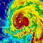
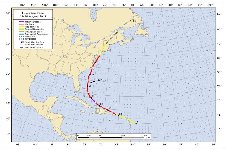
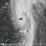
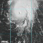
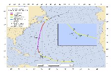
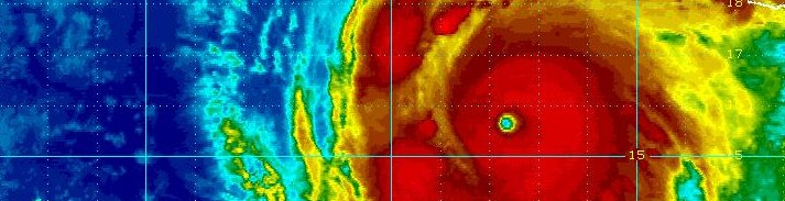
Hurricane Irene
August 24, 2011
Irene was the 9th named storm of the 2011 Atlantic hurricane season. There never has been a hurricane named so late after eight tropical storms.
Irene started as a strong tropical wave from the coast of Africa in mid August. It moved across the Atlantic without much change in structure until it gained convection rapidly east of the Leeward Islands. It was classified as a tropical depression on August 20th. The hurricane center quickly upgraded to tropical storm strength before it moved into the Leewards. A wind gust to 54 mph was reported at Saint Eustatius as Irene passed by. Irene continued west north west and passed over St. Croix and Puerto Rico on the 21st into the morning of the 22nd. Wind gusts generally were in the range of 40-50 mph. Rainfall totals of over 8" with rainbans that stayed over Puerto Rico days later.
Irene was forecast to hit Hispaniola, but managed to stay to the north of the island. Dry air from Hispaniola disrupted the low level flow, but did not severely damage the circulation. Irene started strengthening as it moved past the Turks and Caicos on the 23rd into the early mornng of the 24th. A well developed eye appeared on the morning of the 24th in the southern Bahamas as pressure dropped to 957mb. It was classified as a major hurricane at 115 mph. Early forecasts threatened Florida, but an eastward trend set up steering Irene to the east of the state.
Irene continued north and made landfall at Cape Lookout, NC on saturday morning around 8 am on the 27th. It officially had sustained surface winds of 90 mph, but most winds found did not exceed the 75-80 mph range. In fact most sustained winds over eastern North Carolina were in the 45-60 mph range with gusts to about 75 mph. With widespread rainfall of 6-10" over the area large amounts of trees were toppled resulting in power loss. A surge was also not only felt on the coast but pushed up the inland river basins resulting in sever flooding.
Irene moved offshore that evening near Virginia Beach and made its way up the Mid-Atlantic coast moving into the New Jersey shore. It crossed just west of New York City around 9 am. Wind gusts to around 65 mph were seen in the city with a 91 mph gust on the south side of Long Island at Sayville. Rainfall amounts were in the range of 4-6" in the New York City area southward into the Mid-Atlantic. Heavier rainfall totals in excess of 12" were reported in Vermont where the worst flooding in over 100 years was suffered. Irene continued north though New England into eastern Canada were tropical characteristics were lost.
|
|
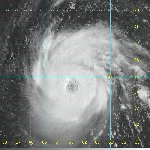
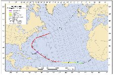
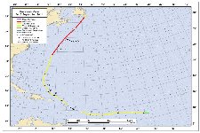
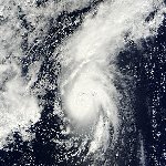
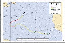
Hurricane Katia
September 5, 2011
Katia was a "classic" looking hurricane on satellite imagery. It formed on August 29th about 400 miles south of the Cape Verde islands. It quickly organized into tropical storm Katia by the following morning. After this, strengthening slowed as the battle with wind shear began. Katia slowly strengthened and was declared a hurricane by September 2nd. Katia remained a minimal hurricane until it started recuring northeast of the Leewards by a little more than 300 miles. At this point Maria started intensifying. By Monday the 5th of September, it became a category 4 hurricane with winds of 135 mph. The hurricane continued north and started to weaken as dry air was injested into the western side. Maria passed roughly half way between Cape Hatteras, NC, and Bermuda on September 8th as it started accelerating north. Maria starting becoming extratropical as it turned northeast and passed a few hundred miles south of Newfoundland on the 10th.
|
|
Hurricane Maria
September 15, 2011
Maria was a hurricane that had several epic battles with upper air wind shear. It formed as tropical depression 14, on September 6, about 700 miles southwest of the Cape Verde islands. It was classified as tropical storm Maria the following day as banding improved. The next 36 hours were marked with severe wind shear where the circulation was badly damaged. By the early morning of the 9th, wind shear relaxed and Maria exploded just to the east of the Lesser Antilles. Once again, as Maria approached the Leewards, windshear picked up and the circulation was damaged. Maria went into another strengthening phase north of Puerto Rico. The Caribbean had mostly dodged the effects of Maria except for heavy rain.
Maria slowed northeast of the Dominican Republic, safely away from land and weakened again. By Thursday the 15, Maria passed to the west of Bermuda. Bermuda picked up rain squalls with winds to minimal tropical storm force. Maria formed a brief eyelike feature well northwest of Bermuda and was named a hurricane at 75 mph. With no recon aircraft or other observations it is questionable if Maria was truly a hurricane. Maria started accelerating northeast and passed very close to Cape Race, Newfoudland on the 16th. It looked like nearly all tropical characteristics were gone by then as it moved into the northern north Atlantic ocean.
|
|
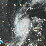
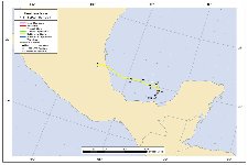
Hurricane Nate
September 9, 2011
Nate was upgraded from a tropical storm to a minimal hurricane with post season analysis. It formed west of the Yucatan peninsula and slowly moved west over the Bay of Campeche over the period of about four to five days. It never obained an impressive satellite representation. It made landfall on September 11 just northeast of Veracruz, Me
|
|
Hurricane Ophelia
September 30, 2011
Ophelia was a long lived tropical cyclone that dissipated and redeveloped. Ophelia formed in the deep tropics on September 20th late in the evening. It looked as if the circulation could have been classified as a tropical depression about 24-36 hours earlier. Instead the Huricane Center went straight to tropical storm strength. Ophelia continued west toward the Leewards fighting windshear and staying as a weak tropical storm most of the way. The circulation dissipated near the Leeward islands on the 25th. It looked as if the last remnants of the circulation moved into the northern Leewards.
A couple of days later a mass of convection exploded east of the Leewards and Ophelia was revived. It is my opinion that this was actually a new tropical cylone and not Ophelia. The new Ophelia fought wind shear and slowly organized east of the Leewards, with only a few rainbands affecting the Islands. Ophelia became a hurricane on the 29th as windshear relaxed. A rapid deepening phase began on Friday morning the 30th and lasted all day. Ophelia became a classic hurricane from satellite imagery. Top sustained winds reached 120 mph, a major hurricane on the Saffir-Simpson scale. By Saturday, Ophelia was passing Bermuda to the east with raindbands and winds just under tropical storm force affecting the island. Ophelia was at its strongest due east of Bermuda at 140 mph. It rapildy accelerated toward eastern Canada where it made landfall on the Avalon Peninsula of Newfoundland near daybreak. Officially top sustained winds were estimated at 70 mph, but no land observations confirmed this strength. Ophelia became extratropical as it moved northeast in the northern north Atlantic.
|
|
Hurricane Philippe
October 6, 2011
Philippe was a tropical cyclone that never affected land. It formed south of the Cape Verde Islands on September 24 and was upgraded to a tropical storm shortly thereafter. As with many storms preceeding it, it battled wind shear during its life time. The circulation was so badly sheared that it almost dissipated on the 29th. It made a slight comback and continued to fight wind shear over the next several days. Winds weakened sufficiently that Philippe had a brief opportunity to strengthen on the 6th and 7th of October. It increased to a minimal hurricane before merging with a front and becoming extratropical.
|
Hurricane pictures and summaries main page.
|
|
|
)
)
)
)
)
)
)
)
)
)
)
)