|
|
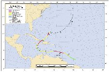
Hurricane pictures / summaries 2010
Satellite images provided by NOAA / NASA / MODIS. Hurricane tracks courtesy of the National Hurricane Center.
 Click pictures for close up view Click pictures for close up view
|
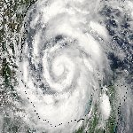
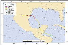
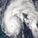
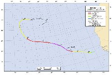
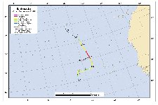
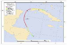
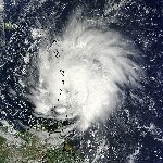
Hurricane Alex
June 29, 2010
Alex took several days to organize in the westcentral Caribbean. On June 25 it was classified as the first tropical depression of the 2010 hurricane season just northeast of Honduras. Alex continued westward and by 24 hours later was making landfall on the coast of Belize with 65 mph winds. By Monday, June 28, Alex was west of the Yucatan peninsula in the Bay of Campeche. Alex slowly gained strength and took on a multi-spiraled look by Tuesday. The eyewall closed off Tuesday evening and Alex was named the first hurricane of the 2010 Atlantic hurricane season.
A ridge of high pressure was building over the central United States Wednesday sending Hurricane Alex on a more westerly course. With warm Gulf waters and light wind shear, Alex's central pressure started to drop much more rapidly. Alex made landfall near the town of Soto La Marina, Mexico at 9 pm cdt with top sustained winds of 105 mph. Lowest pressure at landfall was 947 mb. Alex brought heavy rain to Mexico and south Texas. Rainfall amounts of 6 1/4" to near 7 1/4" was reported at Brownsville and McAllen, Texas respectively. Doppler radar estimated rainfall in excess of 11 inches in south Texas with similar amounts in northeast Mexico.
|
|
Hurricane Danielle
August 26, 2010
Tropical depression 6 of the Atlantic hurricane season was classified in the far eastern tropical Atlantic on August 21. It quickly strengthened and became a hurricane by the evening of the 23rd of August. Soon after reaching hurricane strength, dry air and wind shear disrupted the circulation so that it weakened into a tropical storm again. This was short lived as strengthening followed again as Danielle was turning northwest in the general direction of Bermuda. An impressive eyewall formed on the afternoon of the 26th and was classified as a category 3 hurricane late that afternoon. Danielle continued to strengthen overnight and by the next morning it was a category 4 at 135 mph. The course gradually shifted north northeast which took it comfortably east of Bermuda. Bermuda dodged Danielle with no effects other than some high surf. The hurricane gradually weakened into an extratropical cyclone over the northern reaches of the north Atlantic ocean.
|
|
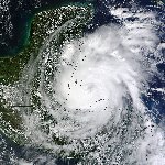
Hurricane Earl
September 1, 2010
Hurricane Earl would alarm many residents of the U.S. east coast. It formed southwest of the Cape Verde Islands on August 25th and was declared tropical storm Earl later that day. After this, Earl did not change much for days. It very slowly organized as it moved just north of due west and finally reached hurricane strength just east of the Leeward Islands. At this point, Hurricane Earl started to deepen more quickly. Winds climbed to 100 mph as the center passed just northeast of Antigua. A slight turn to the west northwest allowed the eye of Earl to move about 25 miles north of the northern Leeward Islands on the 30th. Overall, heavy rainfall and tropical storm winds were seen in the Leewards. Some gusts to near hurricane force may have been seen in the northern Leewards. By the time Earl was pulling away from north of the Virgin Islands winds had increased to 120 mph.
Earl had started to move around the periphery of the Bermuda high and starting turing more northwest just before arriving in the southern Bahamas. The Turks and Caicos and Bahamas also were spared as little effects from the hurricane were seen. Earl was at its strongest on the 31st as its pressure dropped to 931 mb. Top sustained winds were at 135 mph. From this point Earl moved generally northward ahead of an upper air trough which allowed the hurricane to pick up speed as it moved offshore of the east coast. Earl passed about 85 miles east of Cape Hatteras North Carolina on the night of the 3rd. The Outer Banks of North Carolina saw tropical storm force winds and heavy rainfall. During the day, Earl moved quickly northward 150-200 miles off of the Mid-Atlantic coast. Very little effects were seen between Virgina to Long Island. Earl continued to weaken and was classified a 70 mph tropical storm well east of Long Island, NY. Earl started to turn more northeast allowing Earl to move east of Cape Cod. Some winds to near tropical storm force were seen in extreme eastern Massachusettes.
Tropical storm Earl made landfall east of Cape Sable, Nova Scotia on the morning of the 5th of September. It crossed Nova Scotia and moved into the Gulf of St. Lawrence. Earl continued to have a large eyelike structure as it crossed Nova Scotia. Its pathway took it farther northeast into eastern Canada as it lost tropical characteristics over the next day. Many communities were spared from Earl's destruction as it turned several times in its lifetime.
|

|
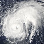
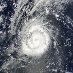
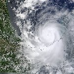
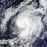
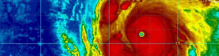
Hurricane Igor
September 13, 2010
As others before it this season, Igor formed near the Cape Verde Islands. It was classified as a tropical storm on Wednesday, September 8th. It very gradually organized and displayed a large, well defined eyelike structure on the afternoon of September 11th. Igor would strengthen into a hurricane overnight and undergo rapid deepening on Sunday, September 12 over 1000 miles east of the Leeward Islands. Top sustained winds climbed to an estimated 135 mph. Igor slightly strengthened overnight into Monday so that its top winds leveled out at 150 mph. The satellite imagery showed the image of a "classic" hurricane over the open waters of the Atlantic.
|
|
Hurricane Julia
September 14, 2010
Hurricane Julia became the 5th hurricane of the 2010 Atlantic hurricane season. Also in a similar fashion, Julia formed near the Cape Verde Islands off of the coast of Africa. It was classified as tropical depression 12 on September 12th. It strengthened more quickly than previous tropical cyclones earlier in the season, becoming a tropical storm on the 13th and minimal hurricane by the morning of the 14th. By that time Julia's effects were pulling away from the Cape Verde Islands.
|
|
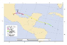
Hurricane Karl
September 16, 2010
A very strong tropical wave pushed into the eastern Caribbean Sea on September 11 which brought heavy showers and storms across the Lesser Antilles. After being on the verge of being declared a tropical depression, its structure became less organized. Several days later the tropical disturbance moved into the western Caribbean Sea where upper air conditions were more favorable for development. By September 14 tropical storm Karl was classified about 175 miles east of Belize. Karl made landfall on the southeast coast of Mexico on the morning of the 15th. It emerged into the Bay of Campeche after crossing the Yucatan peninsula and became a hurricane on the 16th at 75 mph. Karl was a small system that started to rapidly deepen and strengthened to 130 mph east of Veracruz on the 17th. It weakened slightly as it made landfall just north of Veracruz, Mexico around midday.
|
|
Hurricane Lisa
September 25, 2010
A strong tropical wave was classified as tropical storm Lisa on September 21 a little over 500 miles northwest of the Cape Verde Islands. Forecast models handled Lisa poorly as it meandered for a few days. It eventually started to move in a northeast direction. Wind shear ripped at Lisa keeping the tropical cyclone struggling. Lisa did develop a cluster of thunderstorms and it started to strengthen. It was briefly classifed as a minimal hurricane at 75 mph. We believe that this was an overestimate and that Lisa stayed below hurricane strength. Lisa was short lived and weakened shortly after officially being classified as a hurricane
|
|
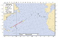
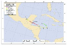
Hurricane Otto
October 8, 2010
Otto formed from an upper air low east of the Turks and Caicos on October 6. It became briefly more disorganized the next day before oranizing and acquiring tropical chararcteristics. It started to rapidly move northeast and was classifed as an 80 mph hurricane southeast of Bermuda. We think that Otto was not actually a hurricane but a strong tropical storm. It transformed into a extratropical cyclone over the next few days. It affected very few locations in its lifetime
|
|
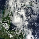
Hurricane Paula
October 12, 2010
A cluster of thunderstorms gradually developed east of Nicaragua. By October 10 the cluster took on a rounded appearance and looked as to have reached tropical depression strength. The Hurricane Center waited unitl the next day and classified tropical storm Paula. It had passed the coast of Nicaragua and Honduras bringing several inches of rain by then. Paula began to deepen rapidly as it drifted north toward the Yucatan Channel reaching 100 mph on the 12th. It slowed and started weakening as wind shear took over. Paula made landfall on the western tip of Cuba on the 14th, officially as a minimal hurricane. It appeared to be weaker than that actually. It slowly weakened on the north coast of Cuba the following day as land disrupted its circulation
|
|
Hurricane Richard
October 24, 2010
Tropical depression 19 began forming between Honduras and the Cayman Islands on October 20. By the morning of the 21st, tropical storm Richard was classified as it moved westward. Richard kept on a westward course taking just north of Honduras. It strengthened to a hurricane north of Roatan, Honduras on the 24th, although the Bay Islands did not receive hurricane force winds. Richard turned west northwest which took it into Belize barely north of Belize City on the evening of the 24th at 90 mph. Thankfully Richard made landfall as it was starting a rapid deepening phase and would have become much stronger if still over water.
|

|
Hurricane Shary
October 30, 2010
Shary was a small tropical cyclone that was classified about 250 miles south of Bermuda on October 29th. It rapidly moved northeast, comfortably east of Bermuda. The Hurricane Center upgraded Shary to a hurricane as it moved northeast of Bermuda. We thought that Shary was a weaker system that should not have been rated a hurricane. It gained extratropical characteristics over the next 24-36 hours over the open Atlantic.
|
|
Hurricane Tomas
October 30, 2010
Tomas formed from a large area of disturbed weather about 400 miles east southeast of the Windwards on the 29th of October. It became more organized and was classified as tropical storm Tomas that afternoon. Saturday the 30th, Tomas moved through the Windward islands just north of St. Vincent as a minimal hurricane. The eye was impressive on radar and winds were increased to 90 mph as it entered the eastern Caribbean Sea. No reports to hurricane force were noted in the Islands. Wind shear started to pick up and rapidly strip Tomas of its deep convection on November 1. Tomas continued west north of Aruba in a disorganized state becoming a tropical depression on the 3rd. The wind shear lessened later in the day and Tomas reformed into a tropical storm again
|
Hurricane pictures and summaries main page.
|
|
|
)
)
)
)
)
)
)
)
)
)
)
)
)
)
)
)
)
)
)
)
)
)
)
)