|
|
Hurricane pictures / summaries 2005
Satellite images provided by NOAA / NASA / MODIS. Hurricane tracks courtesy of the National Hurricane Center.
 Click pictures for close up view Click pictures for close up view

|
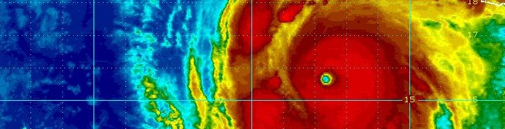
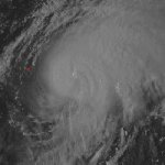
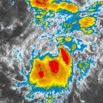
Hurricane Cindy
July 5, 2005
Cindy formed near the Yucatan Peninsula and moved north through the Gulf of Mexico. It strengthened briefly to a minimal hurricane before landfall at Grande Isle, Louisiana. After moving briefly over Gulf waters again, it made its second and final landfall at Ansley, Mississippi. A storm tide of 4-6 feet was observed from eastern Louisiana to the Mississippi coast. Cindy spawned 33 tornadoes from Mississippi to Virginia. One tornado in Hampton, Georgia hit the Atlanta Motor Speedway causing $40 million in damage.
|
|
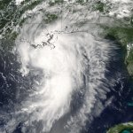
Hurricane Dennis
July 10, 2005
Hurricane Dennis formed from a tropical depression near the Windward Islands. It moved northwest across the Caribbean Sea, bringing torrential rain and damaging winds to Jamaica as it moved just north of the island. Cabo Cruz reported a gust to at least 148 mph. Heavy rainfall also fell in Jamaica. Mavis Bank measured 24.54" of rain. Dennis then moved along the south coast of Cuba making landfall in west central part of the country with damaging winds. Topes De Collantes measured a 24 hour total of 27.67" of rain. More probably fell there. Hurricane Dennis moved north across the Gulf of Mexico strengthening into a category 4 hurricane. It made landfall at Santa Rosa Island, FL as a category 3 hurricane. A 6-7 foot storm tide was observed near where the center crossed the coast. Gusts to 121 mph was clocked at Navarre and 104 mph at Eglin AFB
|
|
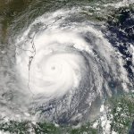
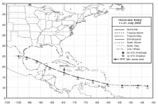
Hurricane Emily
July 19, 2005
Hurricane Emily was the earliest category 5 hurricane to form and the only one to be observed in July. It formed southeast of the southern Windward Islands and made a direct hit on Grenada. Roof damage occured in Grenada, St. Vincent and the Grenadines, and Tobago. Official measurements at Port Salines measured a gust to 67 mph. Considerably stronger winds were likely on the north side of the island at higher elevations. Hurricane Emily continued across the Caribbean Sea and strengthened into a category 5 about 100 miles southwest of Jamaica. It made landfall near Cozumel and Playa del Carmen as a cat 4. A storm surge on 15 feet was estimated at San Miguel on Cozumel. Hurricane Emily weakened over the Yucatan but continued northwest and restrengthened into a category 3. Emily made its final Mexican landfall near San Fernando. A fishing community at Laguna Madre near the landfall site lost 80-90% of its homes.
|
|
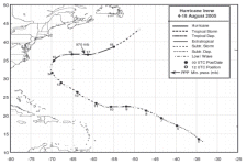
Hurricane Irene
August 15, 2005
Irene formed southwest of the Cape Verde Islands off of the coast of Africa. It made a rather long curve around Bermuda through the open waters of the North Atlantic Ocean. There
were no reports of damage from Hurricane Irene. Irene's top sustained winds were 105 mph well north of Bermuda.
|
|
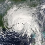
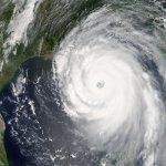
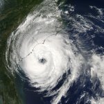
Hurricane Katrina
August 28, 2005
Hurricane Katrina was the costliest U.S. hurricane on record and one of the worst natural disasters in U. S. history. Katrina will be remembered for its catastrophic flooding in New Orleans due to levee failure. Katrina formed in the central Bahamas and moved northwest. It made landfall in south Florida on the Broward/Miami-Dade counties line as a category 1 hurricane. Virginia Key reported a gust to 93 mph. Heavy rain also fell. Key West had 10.05" and Homested 14.04". As Katrina moved over the Gulf of Mexico, it turned north and strengthened into a category 5 hurricane with top sustained winds of 175 mph.
Katrina was large in size and gererated a large wind field. This created huge waves in the Gulf where a bouy 74 miles south of Dauphin Island, AL measured a peak significant wave height of 55 feet. Katrina ingested some dry air and weakened to a category 3 hurricane as it made landfall near Buras, LA. It briefly passed over the Gulf waters again and made its last landfall on the Mississippi - Louisiana border. In Louisiana, a storm surge of 11.8' was measured at New Orleans Lakefront airport. New Orleans International airport had a peak gust to 98 mph. New Orlean's wind damage was comparable only to a category 1 or 2 hurricane. The majority of the damage in New Orleans was due to levee failure. Up to 80% of the city of New Orleans was flooded with up to 20' of water. The Mississippi coast suffered catastrophic damage due to storm surge and wind damage. A surge of 24-28 feet was measured along the Mississippi coast with the highest near Pass Christian at 27.8'. The storm surge went inland for about six miles, but up to twelve along the rivers. Pearl River EOC at Poplarville recorded a wind gust to 135 mph. In all, total damage estimates were
placed near $81 billion.
|
|
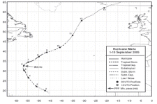
Hurricane Maria
September 5, 2005
Hurricane Maria was another tropical cyclone that stayed well out to sea. It briefly was a major hurricane with top sustained winds of 115 mph. Maria mergerd with a low in the northern North Atlantic.
|
|
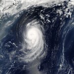
Hurricane Nate
September 8, 2005
Hurricane Nate was a category 1 hurricane that formed south-southwest of Bermuda and passed to its southeast. It caused no damage as it moved northeast through the North Atlantic. It became extratropical and weakened well west of the Azores.
|
|
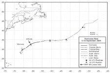
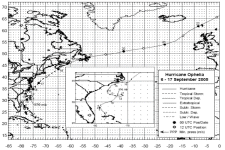
Hurricane Ophelia
September 13, 2005
Ophelia developed in the northern Bahamas. After moving north and making a loop in its path, it brushed the North Carolina coast. Cape Lookout, NC measured the highest official gust to 92 mph. Davis had an unofficial gust to 104 mph. Storm surge of 4-6' was observed in Pamlico Sound. Heavy rain fell, especially in eastern North Carolina. The Oak Island Water Treatment Plant measured 17.5". Ophelia continued northeast paralleling the U.S. east coast. It became an extratropical low as it passed Nova Scotia and New Brunswick, Canada. It eventually dissipated in the North Sea.
|
|
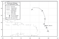
Hurricane Philippe
September 18, 2005
Philippe formed east of the Lesser Antillies and only briely made category 1 hurricane status as it moved northward. The was no damage associated with Hurricane Philippe.
|
|
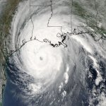
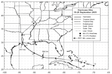
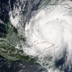
Hurricane Rita
September 13, 2005
Hurricane Rita was the "forgotten hurricane" of 2005 that struck southwestern Louisiana and the upper Texas coast after Hurricane Katrina. It was a category 5
hurricane that had the 4th lowest pressure in the Atlantic basin on record. Rita formed near the southern Bahamas and attained hurricane strength south of the Florida Keys. Sand Key reported a wind gust to 92 mph. South Florida, including the Keys generally saw about 1-5" of rainfall.,br>
Hurricane Rita rapidly deepened as it moved into the central Gulf of Mexico where it reached category 5 strength. Top sustained winds of 180 mph were estimated by the Hurricane Hunters. Because of the strength of Hurricane Rita, and projected track, a large evacuation of southeast Texas was ordered. Over 2 million may have evacuated. Rita's track actually stayed east of Galveston and Houston. It made landfall in southwest Louisiana near Johnson's Bayou as a category 3 hurricane. Port Arthur, TX measured a gust to 116 mph. Rainfall totals up to 10-15" were measured with Rita. Hurricane Rita also spawned 101 tornadoes - 4th behind Ivan, Beulah, and Frances. Storm surge was as high as 15 feet in Cameron Parish, and many homes were completely wiped off of their foundations.
|
|
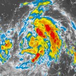
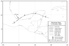
Hurricane Stan
October 2, 2005
Hurricane Stan only reached minimal hurricane strength, but will be remembered for the intense flooding it caused in Central America. Stan formed in the northwest Caribbean Sea and
moved over the Yucatan Peninsula. It then moved southwest into Mexico again, becoming a category 1 hurricane briefly. Over 2000 people may have perished in Mexico and other Central American
countries due to the flooding rains.
|

|
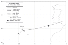
Hurricane Vince
October 9, 2005
Vince was the farthest east forming hurricane known to exist in the Atlantic basin. It also the only known tropical cyclone to reach the Iberian Peninsula. Vince made landfall on the coast of Portugal and Spain bringing up to 3.3" of rain at Cordoba, Spain.
|
|
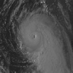
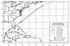
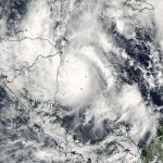
Hurricane Wilma
October 19, 2005
Hurricane Wilma set the record for the lowest pressure ever measured in the Atlantic basin at 882 millibars. Wilma formed just to the southwest of Jamaica. After only slow development for a few days, it strengthened at the incredible rate from a 70 mph tropical storm to a 175 mph category 5 hurricane in 24 hours! The diameter of the eye was estimated at 2 miles at one point. This is extremely small for any hurricane and the smallest ever measured. Hurricane Wilma had the largest 6, 12, and 24 hour pressure drop of any any hurricane in the Atlantic basin on record. The pressure dropped 97 mb in 24 hours!
Wilma weakened to a category 3 hurricane as it moved northwest and struck Cozumel. It still devasted the tourist industry as winds were clocked to 130 mph at Cozumel. A rainfall total of 62.05" was measured at Isla Mujeres! From there, Hurricane Wilma turned northeast to make landfall near Cape Romano, Florida with top sustained winds at 120 mph. South Florida experienced a storm surge mostly in the range of 4-8 feet. Marathon reported a 9' storm surge and the southwest side of Grand Bahama Island a 12' surge. Most of south Florida sustained category 1 hurricane conditions. Wilma was the third costliest hurricane only behind Hurricane Katrina and Hurricane Andrew.
|
|
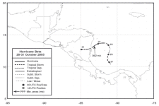
Hurricane Beta
October 29, 2005
Hurricane Beta was a small category 2 hurricane that formed north of Panama. It brought extensive damage to the island of Provindencia then moved westward. It then made landfall on the coast of Nicaragua. Storm surge affected the coast of Nicaragua. Heavy rainfall occured in both NIcaragua and Honduras.
|
|
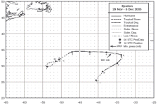
Hurricane Epsilon
December 12, 2005
Hurricane Epsilon was the six hurricane to form during the month of December on record. It developed in the central North Atlantic Ocean. There was no known damage from Epsilon.
|
Hurricane pictures and summaries main page.
|
|
|
|
|
)
)
)
)
)
)
)
)
)
)
)
)
)
)
)
)
)
)
)
)
)
)
)
)
)
)
)
)
)