Hermine
Posted: Fri Sep 23, 2022 5:00 pm
Friday Evening Update
Heavy showers over the Canary Islands
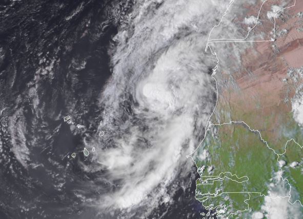
Hermine was recently classified as convection organized today. Locally heavy showers are being seen to the south of the low center in rain bands and some tropical storms force wind gusts may be seen over higher terrain, but will soon quiet down.
The Weather Situation
SUMMARY OF 800 PM CVT...2100 UTC...INFORMATION
----------------------------------------------
LOCATION...18.6N 20.5W
ABOUT 290 MI...470 KM NE OF THE CABO VERDE ISLANDS
MAXIMUM SUSTAINED WINDS...40 MPH...65 KM/H
PRESENT MOVEMENT...NNW OR 335 DEGREES AT 10 MPH...17 KM/H
MINIMUM CENTRAL PRESSURE...1002 MB...29.59 INCHES
Tropicast: Visible Satellite
Tropical Weather Forecast:
Hermine is moving north, away from the Canary Islands. It will lose tropical characteristics as it moves over cooler water. It will also be facing increasing vertical shear weakening the system.
Heavy showers over the Canary Islands
Hermine was recently classified as convection organized today. Locally heavy showers are being seen to the south of the low center in rain bands and some tropical storms force wind gusts may be seen over higher terrain, but will soon quiet down.
The Weather Situation
SUMMARY OF 800 PM CVT...2100 UTC...INFORMATION
----------------------------------------------
LOCATION...18.6N 20.5W
ABOUT 290 MI...470 KM NE OF THE CABO VERDE ISLANDS
MAXIMUM SUSTAINED WINDS...40 MPH...65 KM/H
PRESENT MOVEMENT...NNW OR 335 DEGREES AT 10 MPH...17 KM/H
MINIMUM CENTRAL PRESSURE...1002 MB...29.59 INCHES
Tropicast: Visible Satellite
Tropical Weather Forecast:
Hermine is moving north, away from the Canary Islands. It will lose tropical characteristics as it moves over cooler water. It will also be facing increasing vertical shear weakening the system.