Page 1 of 1
Peter
Posted: Sun Sep 19, 2021 7:37 am
by Tropical Inspector
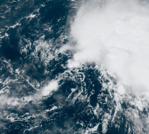
Sunday Midday Update
Peter is badly sheared
The Weather Situation
Peter is a badly sheared, weak cyclone with deep convection just north and well east of the center of circulation.
Current Tropical Weather
SUMMARY OF 1100 AM AST...1500 UTC...INFORMATION
-----------------------------------------------
LOCATION...17.6N 56.5W
ABOUT 435 MI...700 KM E OF THE NORTHERN LEEWARD ISLANDS
MAXIMUM SUSTAINED WINDS...45 MPH...75 KM/H
PRESENT MOVEMENT...WNW OR 290 DEGREES AT 17 MPH...28 KM/H
MINIMUM CENTRAL PRESSURE...1007 MB...29.74 INCHESS
Tropical Weather Forecast:
Peter is expected to continue to fight wind shear over the next several days. It will stay northeast of the Leewards, but could possibly affect Bermuda next weekend.
Tropicast: Visible Satellite
Re: Peter
Posted: Mon Sep 20, 2021 6:44 am
by Tropical Inspector
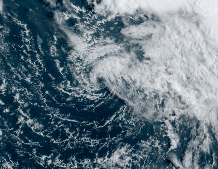
Monday Morning Update
Peter is badly sheared
The Weather Situation
Peter is a badly sheared, weak cyclone with deep convection well east of the center of circulation. IMO, Peter is over represented. I would guess top winds are closer to 40 mph in convection well to the east.
NHC Official Data
SUMMARY OF 500 AM AST...0900 UTC...INFORMATION
----------------------------------------------
LOCATION...19.1N 59.5W
ABOUT 245 MI...390 KM ENE OF THE NORTHERN LEEWARD ISLANDS
MAXIMUM SUSTAINED WINDS...50 MPH...85 KM/H
PRESENT MOVEMENT...WNW OR 290 DEGREES AT 14 MPH...22 KM/H
MINIMUM CENTRAL PRESSURE...1005 MB...29.68 INCHES
Tropical Weather Forecast:
Peter is expected to continue to fight wind shear over the next several days. It will stay northeast of the Leewards, but could possibly affect Bermuda next weekend.
Tropicast: Visible Satellite
Re: Peter
Posted: Tue Sep 21, 2021 8:24 am
by Tropical Inspector
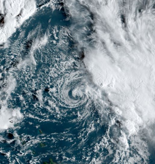
Tuesday Morning Update
Peter almost is dissipated
The Weather Situation
I'm really not sure how Peter is being given a 50 mph windspeed. I don't agree that the Dvorak representation would call for 50 mph sustained winds . That would entail gusts to 65-70 mph. I just can't see that. IMO, this is a 30-35 mph tropical depression. The circulation center is becoming diffuse and it really is a waste to send a Hurricane Hunter to investigate.
NHC Official Data
SUMMARY OF 500 AM AST...0900 UTC...INFORMATION
----------------------------------------------
LOCATION...19.6N 63.8W
ABOUT 105 MI...170 KM NNW OF THE NORTHERN LEEWARD ISLANDS
MAXIMUM SUSTAINED WINDS...50 MPH...85 KM/H
PRESENT MOVEMENT...W OR 265 DEGREES AT 12 MPH...19 KM/H
MINIMUM CENTRAL PRESSURE...1007 MB...29.74 INCHES
Tropical Weather Forecast:
Peter is expected to continue to fight wind shear over the next several days.
Tropicast: Visible Satellite
Re: Peter
Posted: Tue Sep 21, 2021 8:46 pm
by Tropical Inspector
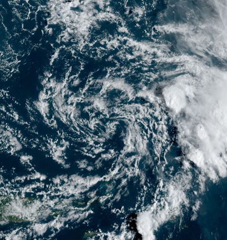
Tuesday Evening Update
Peter officially a tropical depression
The Weather Situation
NHC finally downgraded Peter to a tropical depression late this afternoon. It's ironic as deep convection exploded and the system looked better than any time in its lifecycle. Anyhow this evening convection is quieting down again and I believe that winds are 35 - 40 mph.
NHC Official Data
SUMMARY OF 500 PM AST...2100 UTC...INFORMATION
----------------------------------------------
LOCATION...20.5N 65.0W
ABOUT 160 MI...260 KM NNE OF SAN JUAN PUERTO RICO
MAXIMUM SUSTAINED WINDS...35 MPH...55 KM/H
PRESENT MOVEMENT...WNW OR 300 DEGREES AT 8 MPH...13 KM/H
MINIMUM CENTRAL PRESSURE...1009 MB...29.80 INCHES
Tropical Weather Forecast:
Peter is expected to dissipate over the next 24 hours.
Tropicast: Visible Satellite Late Tuesday Afternoon

Re: Peter
Posted: Wed Sep 22, 2021 4:53 pm
by Tropical Inspector
Wednesday Evening Update
Peter signing off
The Weather Situation
Peter's low pressure center is very diffuse, despite some impressive convection hanging on to the east / northeast of the low.
NHC Official Data
SUMMARY OF 500 PM AST...2100 UTC...INFORMATION
----------------------------------------------
LOCATION...21.7N 66.7W
ABOUT 230 MI...370 KM N OF SAN JUAN PUERTO RICO
MAXIMUM SUSTAINED WINDS...35 MPH...55 KM/H
PRESENT MOVEMENT...NNW OR 340 DEGREES AT 5 MPH...7 KM/H
MINIMUM CENTRAL PRESSURE...1008 MB...29.77 INCHES
Tropical Weather Forecast:
Peter is essentially dissipated.
Tropicast: Visible Satellite