Page 1 of 1
Beta
Posted: Thu Sep 17, 2020 8:35 pm
by Tropical Inspector
Thursday Evening Update
TD 22 forms
The Weather Situation
Recon found that the disturbed area of convection had enough of a circulation to be classified.
For more frequent updates: Twitter:
https://twitter.com/richjohnsonwx
Current tropical weather
As of 4:00 PM CDT TD 22 was centered at 21.9 N / 91.4 W or about 330 miles SE of the Mouth of the Rio Grande. It was moving NE 5 mph. Officially top sustained winds are estimated at 35 mph. Pressure was estimated at 1005 hPa (mb).
Tropical Weather Forecast:
TD 22 will meander in the western Gulf of Mexico for a few days. It will drift north, then turn to the west into south Texas.
Tropicast: IR Satellite
Re: TD 22
Posted: Fri Sep 18, 2020 7:23 am
by Tropical Inspector
Friday Morning Update
TD 22 remains disorganized
The Weather Situation
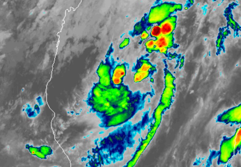
Satellite imagery shows that TD 22 is still trying to organized. It actually appears less organized this morning. Deep convection is well north of the center as it appears to be fighting shear.
For more frequent updates: Twitter:
https://twitter.com/richjohnsonwx
Current tropical weather
As of 4:00 AM CDT TD 22 was centered at 21.9 N / 91.4 W or about 285 miles SE of the Mouth of the Rio Grande. It was moving NNE 6 mph. Officially top sustained winds are estimated at 35 mph. Pressure was estimated at 1005 hPa (mb).
Tropical Weather Forecast:
TD 22 will move around the western Gulf of Mexico for a few days. It may reach hurricane strength. Steering currently will be weak for a few days so track and strength are more uncertain than usual.
Tropicast: IR Satellite
Re: Beta
Posted: Fri Sep 18, 2020 8:33 pm
by Tropical Inspector
Beta classified at 40 mph at 4 pm cdt
Re: Beta
Posted: Sat Sep 19, 2020 8:17 pm
by Tropical Inspector
Saturday Evening Update
Beta not impressive
The Weather Situation
Satellite imagery still shows disorganization. IMO, Beta is more like 50-55 mph with the latest recon data.
For more frequent updates: Twitter:
https://twitter.com/richjohnsonwx
Current tropical weather
As of 7:00 PM CDT Beta was centered at 26.7 N / 92.2 W or about 330 miles ESE of Corpus Christi, TX. It was stationary. Officially top sustained winds are estimated at 60 mph. Pressure was estimated at 997 hPa (mb).
Tropical Weather Forecast:
Beta will be slow moving but is now not expected to become a hurricane. It should reach the central Texas coast Monday and slowly move northeast. This will pose a flood risk.
Tropicast: VisibleSatellite

Re: Beta
Posted: Sun Sep 20, 2020 8:46 am
by Tropical Inspector
Sunday Morning Update
Beta being sheared
The Weather Situation
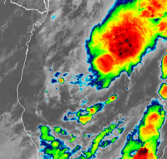
Satellite imagery this morning shows a lot of dry air to the south and west as well as wind shear affecting Beta. Deep convection remains
For more frequent updates: Twitter:
https://twitter.com/richjohnsonwx
Current tropical weather
As of 7:00 AM CDT Beta was centered at 27.1 N / 92.8 W or about 200 miles east of Corpus Christi, TX. It was moving WNW at 3 mph. Officially top sustained winds are estimated at 60 mph. Pressure was estimated at 997 hPa (mb).
Tropical Weather Forecast:
Beta will be slow moving but is now not expected to become a hurricane. It should reach the central Texas coast Monday and slowly move northeast. This will pose a flood risk.
Tropicast: VisibleSatellite
Re: Beta
Posted: Sun Sep 20, 2020 11:33 am
by Tropical Inspector
Beta remains at 60 mph at 10 am cdt
Re: Beta
Posted: Mon Sep 21, 2020 7:57 am
by Tropical Inspector
Monday Morning Update
Beta approaching Texas coast
The Weather Situation
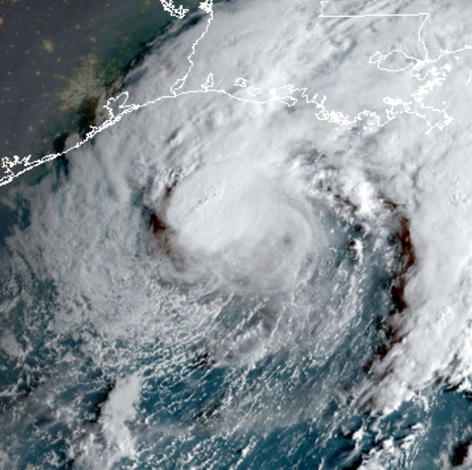
Beta does not look as organized today. It is rather small. The biggest threat will be heavy rainfall of 3-6"
For more frequent updates: Twitter:
https://twitter.com/richjohnsonwx
Current tropical weather
As of 7:00 AM CDT Beta was centered at 27.8 N / 95.5 W or about 70 miles SE of Port O'connor, TX. It was moving west at 6 mph. Officially top sustained winds are estimated at 50 mph. Pressure was estimated at 996 hPa (mb).
Tropical Weather Forecast:
Beta will be slow moving but is now not expected to become a hurricane. It should reach the central Texas coast Monday and slowly move northeast. This will pose a flood risk.
Tropicast: Visible Satellite SUNDAY Late Afternoon
 Tropicast: Radar SUNDAY Late Afternoon
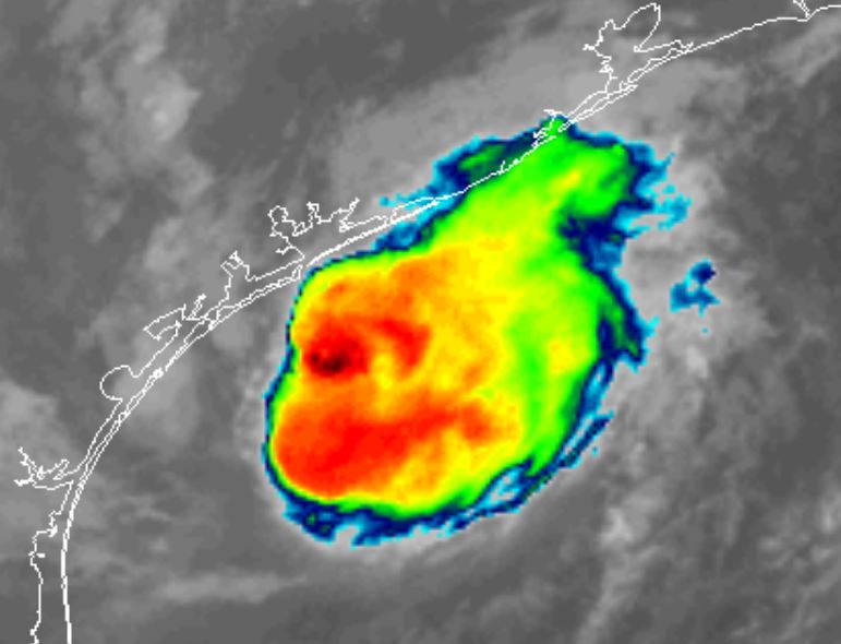
 Tropicast: IR Satellite MONDAY AM
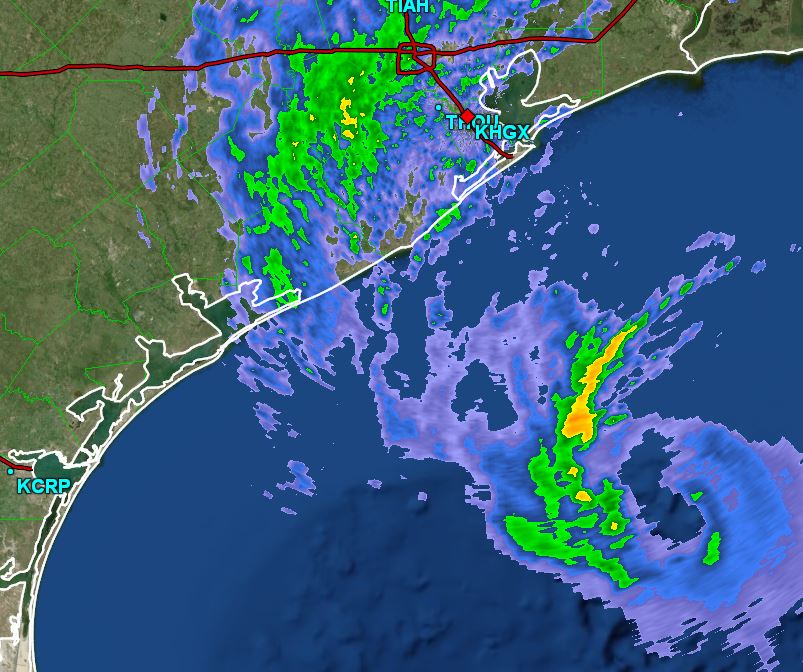
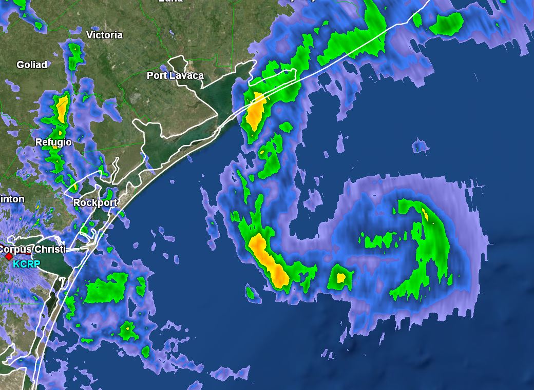
 Tropicast: Radar MONDAY Morning 8:00 AM CDT
Re: Beta
Posted: Mon Sep 21, 2020 3:49 pm
by Tropical Inspector
Monday Evening Update
Beta collapsing
The Weather Situation
Beta is collapsing as it moves onto the coast of Texas. Heavy rainfall will be the biggest threat with some localities getting possibly 3-6" Coastal flooding will gradually subside.
For more frequent updates: Twitter:
https://twitter.com/richjohnsonwx
Current tropical weather
As of 4:00 PM CDT Beta was centered at 28.2 N / 96.1 W or about 25 miles SE of Port O'connor, TX. It was moving northwest at 5 mph. Officially top sustained winds are estimated at 45 mph. Pressure was estimated at 999 hPa (mb).
Tropical Weather Forecast:
Beta will crawl along the Texas coast moving northeast over the next few days. The slow motion will allow for heavy rainfall of possibly 3-6".
Tropicast: Visible Satellite

Re: Beta
Posted: Mon Sep 21, 2020 8:58 pm
by Tropical Inspector
Beta is basically on the coast now near Port O'Connor, TX
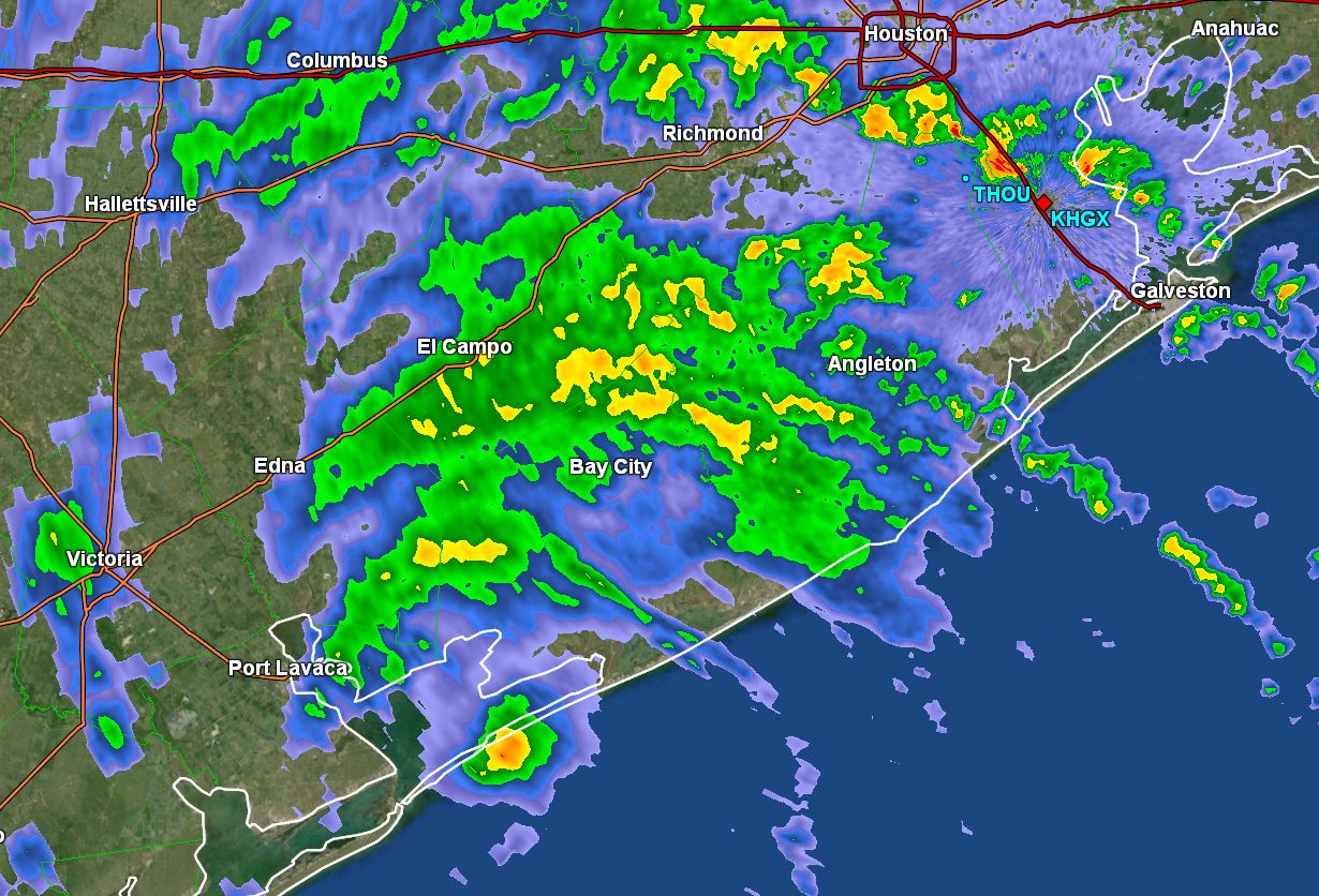
Tropicast: radar
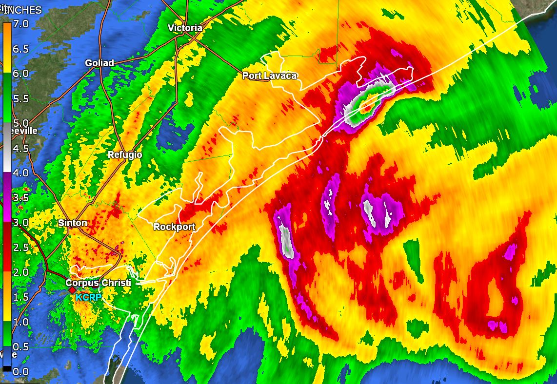
 Tropicast: rainfall estimate
Re: Beta
Posted: Tue Sep 22, 2020 9:27 am
by Tropical Inspector
Tuesday Morning Update
Beta inland
The Weather Situation
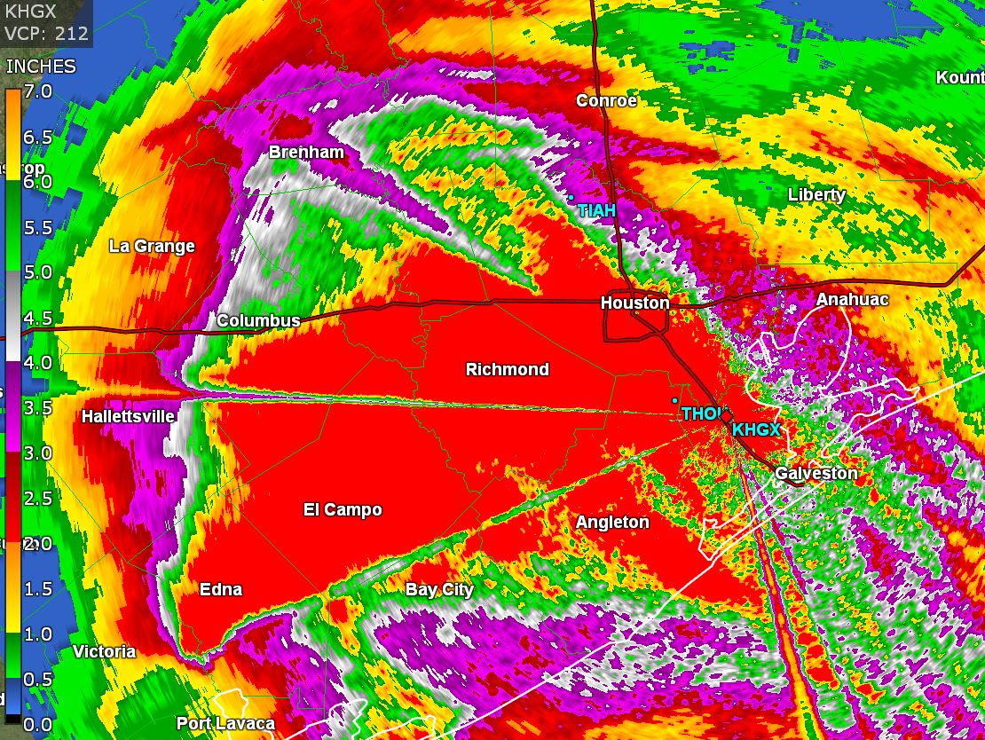
Beta moved inland last night. The main effect was some coastal flooding and heavy rainfall. About 1-4" fell between Corpus Christi and Houston. A locally heavier amount was noted just west of Houston were 5-8" fell.
For more frequent updates: Twitter:
https://twitter.com/richjohnsonwx
Current tropical weather
As of 7:00 AM CDT Beta was centered at 28.8 N / 96.8 W or about 10 miles ESE of Victoria, TX. It was moving northwest at 3 mph. Officially top sustained winds are estimated at 40 mph. Pressure was estimated at 999 hPa (mb).
Tropical Weather Forecast:
Beta will crawl along the Texas coast moving northeast over the next few days. The slow motion will allow for additional heavy rainfall.
Tropicast: Visible Satellite
 Tropicast: GR Level III Radar Estimate
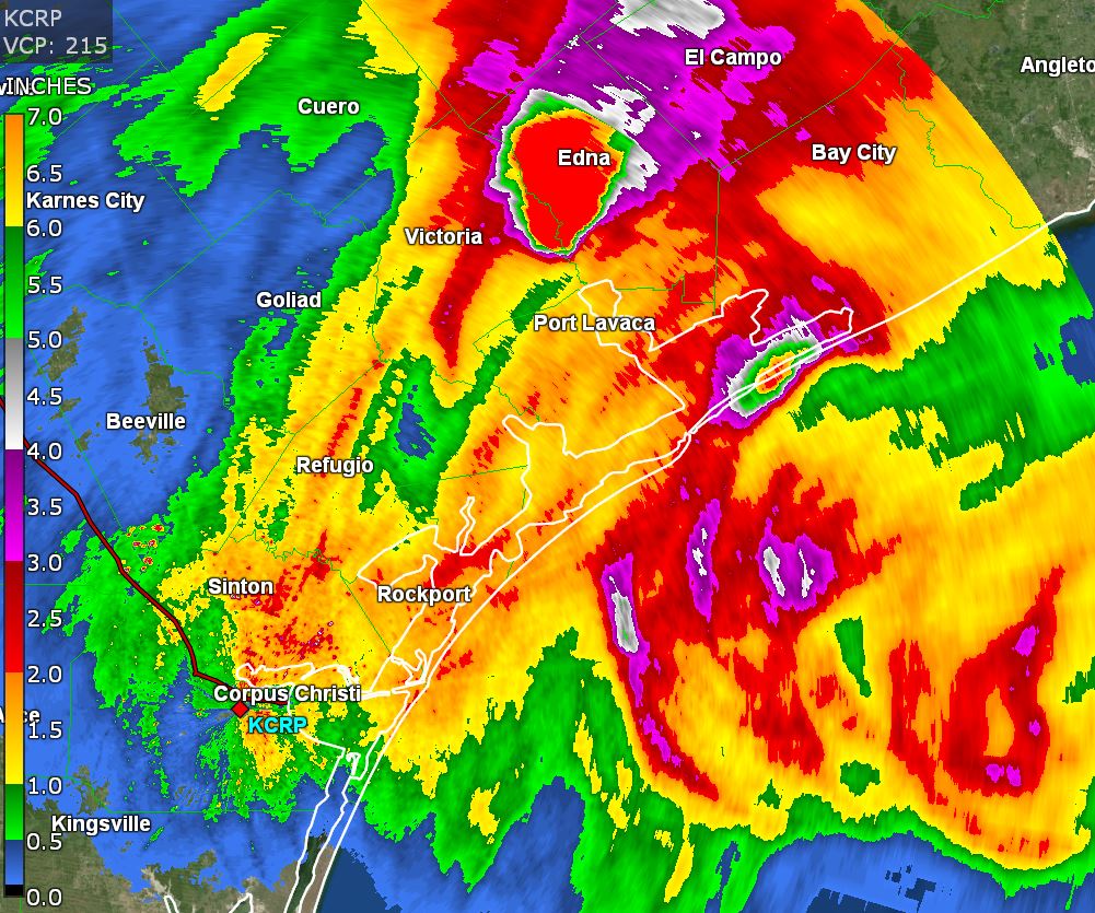 Tropicast: GR Level III Radar Estimate
Re: Beta
Posted: Tue Sep 22, 2020 3:05 pm
by Tropical Inspector
Tuesday Afternoon Update
Tropical Depression Beta weakening
The Weather Situation
Beta will continue to spread heavy showers across southeastern Texas into the northern gulf coastal states into Friday. Some rainfall totals could be in excess of 2-4". Beta will become extratropical within the next 24 hours as it moves ENE into Louisiana.