Page 1 of 1
bill
Posted: Mon Jun 15, 2015 6:47 am
by Tropical Inspector
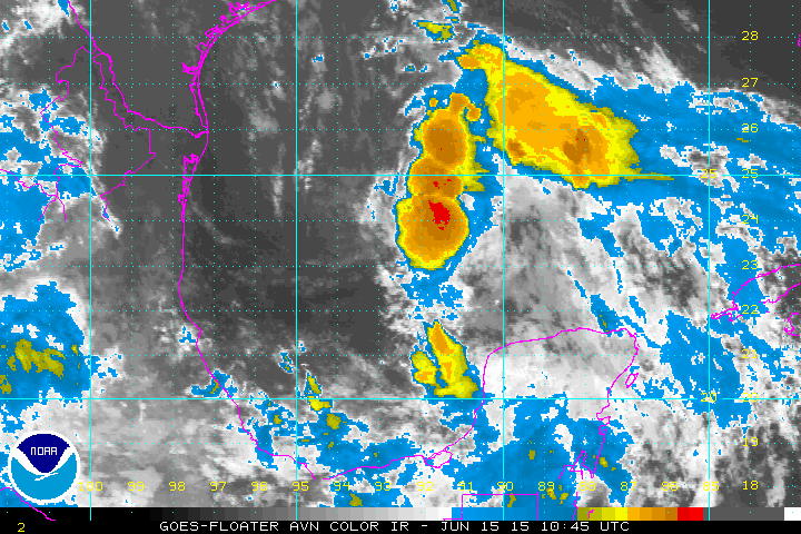
Monday Morning Update
Bill forming in the gulf
The Weather Situation
An upper air low in the southern gulf over the past several days is now organizing. Deep convection is now building near the center of circulation indicating a transformation into a tropical cyclone. Air Force reconnaissance will investigate late this morning. It will likely find winds strong enough to at least classify as a tropical depression if not a storm.
Current Tropical Weather
N/A
Tropical Weather Forecast:
Bill will have a short life span as it moves NW into Texas by Tuesday. Heavy rainfall and flooding will be the biggest threat.
Tropicast: Pacific IR Satellite
Re: bill
Posted: Tue Jun 16, 2015 7:01 am
by Tropical Inspector
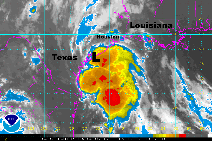
Tuesday Morning Update
Bill just offshore
The Weather Situation
Bill was finally classified as a tropical storm last night at 11 pm EDT. It has gained a little strength, but will make landfall shortly. This will stop further strengthening. The main threat will be from inland flooding. Texas has recently seen heavy rainfall and additional rainfall will raise the flood threat again.
Current Tropical Weather
As of 8 AM EDT / 7 AM CDT Tropical Storm Bill was centered at 28.2 N /96.0 W or 30 miles ESE of Port O'Connor, Texas. It was moving northwest at about 13 mph. Top sustained winds are estimated at 60 mph. Pressure was estimated at 997 mb.
Tropical Weather Forecast:
Bill will move inland shortly on the central Texas coast. Heavy rainfall and flooding will be the biggest threat.
Tropicast: Pacific IR Satellite
Re: bill
Posted: Sat Jun 20, 2015 6:34 am
by Tropical Inspector
Rainfall totals from Bill as of Saturday morning:
...ARKANSAS...
ROGERS 2.1 SE 4.42
BENTONVILLE 4.27
FAYETTEVILLE/SPRINGDALE 4.03
HARRISON/BOONE CO. ARPT 3.85
DELIGHT 2.2 WNW 3.74
SPRINGDALE 6.4 WSW 3.31
SILOAM SPRINGS/SMITH FIELD 3.24
TEXARKANA RGNL ARPT 2.67
EUREKA SPRINGS 4.0 WNW 2.62
SPRINGFIELD/CAPITAL ARPT 2.49
...ILLINOIS...
COOKS MILL 5.14
SCOTT AFB/BELLEVILLE 5.01
SULLIVAN 3 S 4.89
CARBONDALE/MURPHYSBORO 4.83
FLORA 4.70
LAWRENCEVILLE-VINCENNES INTL AP 4.63
ALLENVILLE 1 S 4.50
ELBURN 4.45
MATTOON/CHARLESTON 4.23
SOUTH CAROL STREAM 4.11
BATAVIA 3.87
CAHOKIA/ST. LOUIS 3.58
ROCHELLE 3.43
MANHATTAN 5 SSE 3.26
OAK PARK 1 SE 3.07
DIXON 2 SW 2.64
NEWTON 2.58
TUSCOLA 2.29
NORTH AURORA 2 E 2.23
STE. MARIE 2.11
...INDIANA...
GRISSOM AFB/PERU 6.72
EVANSVILLE RGNL ARPT 5.27
SANDBORN 4.96
BLOOMINGTON/MONROE CO. ARPT 4.87
BICKNELL 4.67
FORT WAYNE/BAER FIELD 4.53
MOROCCO 3.70
MUNCIE/JOHNSON FIELD 3.16
NEW ROSS 2 E 2.87
INDIANAPOLIS INTL ARPT 2.57
ANDERSON 5 NW 2.30
TERRE HAUTE/HULMAN RGNL ARPT 2.12
CHESTERTON 1.70
...KANSAS...
COFFEYVILLE MUNI ARPT 3.64
OLATHE/JOHNSON 1.79
COLLYER 2.1 SE 1.45
...KENTUCKY...
HENDERSON CITY 3.54
FRANKFORT/CAPITAL CITY ARPT 2.12
JACKSON/J. CARROLL 1.96
PADUCAH/BARKLEY 1.90
LEXINGTON/BLUE GRASS FIELD 1.14
...LOUISIANA...
SHREVEPORT RGNL ARPT 4.79
BOSSIER CITY 6.7 NNW 3.84
SHREVEPORT 5.3 SSE 2.42
PLAIN DEALING 3.0 ESE 2.13
RUSTON 1.6 NW 1.85
...MISSOURI...
FORDLAND 4 WNW 8.25
BATTLEFIELD 7.93
OZARK 3 N 7.54
SPOKANE 3 SE 7.00
HARTVILLE 1 E 6.90
HIGHLANDVILLE 6.75
SEYMOUR 6.20
SPRINGFIELD 7 E 6.00
MARSHFIELD 3.6 S 5.48
HURLEY 8 ENE 5.00
EXETER 5.00
COMPETITION 5.00
ROGERSVILLE 4.80
NIXA 2.7 SSW 4.72
LINDEN 2 NE 4.60
NIANGUA 4.37
FORNEY AAF/FORT LEONARDWOOD 4.24
SOUTH SPRINGFIELD 3.10
COLUMBIA RGNL ARPT 2.94
JOPLIN RGNL ARPT 2.60
JEFFERSON CITY ARPT 2.27
...OHIO...
LIMA/ALLEN CO. APRT 5.11
AKRON-CANTON REGIONAL ARPT 3.51
WILMINGTON/CINCINNATI WFO 3.46
DAYTON/JAMES M COX AIRPORT 3.01
CINCINNATI (ASOS) 2.90
...OKLAHOMA...
HEALDTON 3 E 12.53
NEWPORT 11.52
BURNEYVILLE 10.09
SULPHUR 2.5 WSW 8.63
RINGLING 8.27
PAULS VALLEY MUNI APRT 7.35
SULPHUR 7.09
MACOMB 5.2 ESE 5.82
MARIETTA 2.8 SW 5.57
ADA 0.3 NNW 5.45
WEWOKA 7.4 NNW 5.30
NORMAN 3.4 SE 3.61
OKLAHOMA CITY 11.5 S 2.64
MUSKOGEE/DAVIS FIELD AIRPORT 2.55
BARTLESVILLE MUNI ARPT 1.51
...TEXAS...
MONTAGUE 12.50
GANADO 1.5 W 11.77
KIRBYVILLE 1.5 SE 9.51
SEALY 0.3 WNW 9.17
ALICE INTL ARPT 9.03
EL CAMPO 0.5 ENE 8.57
VICTORIA 9 ESE 7.73
ROCKPORT 1.3 WSW 7.51
MANOR 4.7 WSW 7.30
WF SAN JACINTO 7.06
LUFKIN/ANGELINA CO ARPT 6.98
NAVASOTA 8 SE 6.73
FLOUR BLUFF 7 SW 6.59
ARANSAS PASS 1 SSE 6.46
SAN FELIPE 1.0 WNW 6.15
CORPUS CHRISTI 6.14
AUSTIN 4.2 ESE 5.80
SAN ANTONIO INTL ARPT 2.91
HOUSTON/INTERCONTINENTAL 2.51
FORT WORTH NAS 2.34