Iota

Tropical cyclone archives of the 2020 atlantic hurricane season
Post Reply
User avatar
Tropical Inspector
Site Admin
Site Admin
Posts: 3652
Joined: Tue Feb 20, 2007 2:28 pm
Antispam: no
Location: Under a palm tree
Contact:

Iota

Post by Tropical Inspector »

Friday Morning Update

Iota will be classified today

The Weather Situation
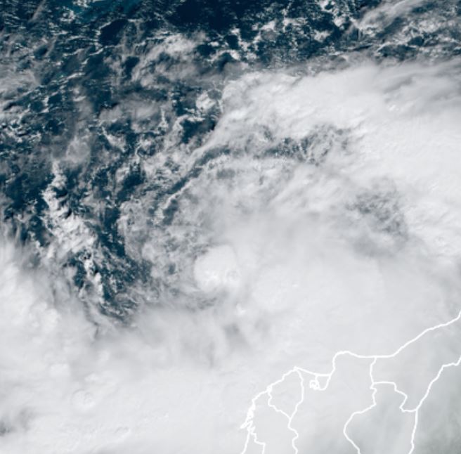
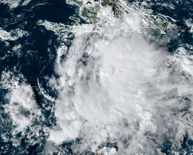
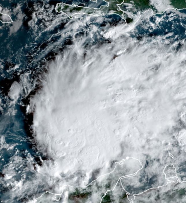
NHC should classify the disturbance in the central Caribbean as Iota soon. It is much more organized than last evening.

For more frequent updates: Twitter: https://twitter.com/richjohnsonwx

Tropical Weather Forecast:
Iota is forecast to track west over the next few days and strengthen. It should be close to the northeast coast of Honduras by early Monday. Interests, especially in Nicaragua, Honduras and Belize should keep an eye on this system.

Tropicast: Visible Satellite Thursday Afternoon
Image

Tropicast: Visible Satellite Friday Morning
Image
Rich Johnson
Twitter: https://twitter.com/richjohnsonwx
Certified Broadcast Meteorologist - Hurricane Expert
User avatar
Tropical Inspector
Site Admin
Site Admin
Posts: 3652
Joined: Tue Feb 20, 2007 2:28 pm
Antispam: no
Location: Under a palm tree
Contact:

Re: Iota

Post by Tropical Inspector »

Sunday Evening Update

Iota strengthening rapidly

The Weather Situation
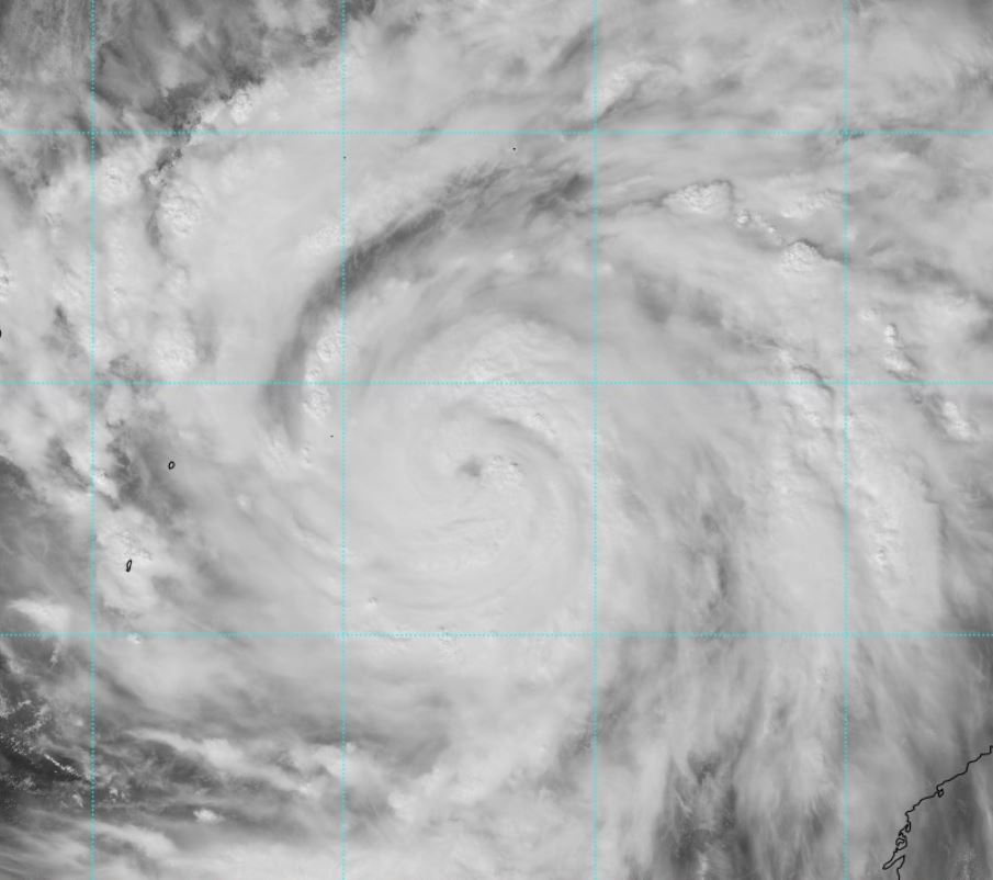
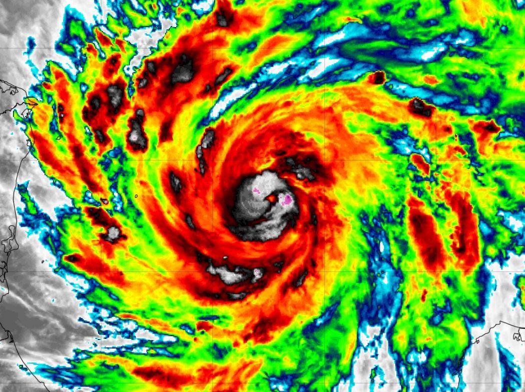
Iota has organized since yesterday and is undergoing rapid strengthening. It appears that Nicaragua is about to a hit from another major hurricane tomorrow.

For more frequent updates: Twitter: https://twitter.com/richjohnsonwx

Current tropical weather
As of 7:00 PM EST Hurricane Iota was centered at 13.3 N / 79.8 W or about 255 miles ESE of Cabo Gracias a Dios on the Nicaragua / Honduras border. It was moving west at 9 mph. Officially top sustained winds are estimated at 100 mph. Pressure was estimated at 964 hPa (mb).

Tropical Weather Forecast:
Iota will make landfall on the coast of Nicaragua Monday as a major hurricane.

Tropicast: Visible Satellite Saturday Afternoon
Image

Tropicast: Visible Satellite Sunday Afternoon
Image

Tropicast: IR Satellite Sunday Afternoon
Image
Rich Johnson
Twitter: https://twitter.com/richjohnsonwx
Certified Broadcast Meteorologist - Hurricane Expert
User avatar
Tropical Inspector
Site Admin
Site Admin
Posts: 3652
Joined: Tue Feb 20, 2007 2:28 pm
Antispam: no
Location: Under a palm tree
Contact:

Re: Iota

Post by Tropical Inspector »

Monday Morning Update

Iota now a top end cat 4

The Weather Situation
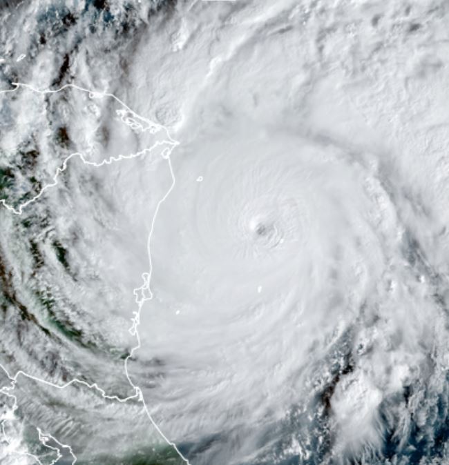
Iota has continued to rapidly strengthen. Satellite presentation is sadly devastating as it moves toward the same location that hurricane Eta made landfall two weeks ago.

For more frequent updates: Twitter: https://twitter.com/richjohnsonwx

Current tropical weather
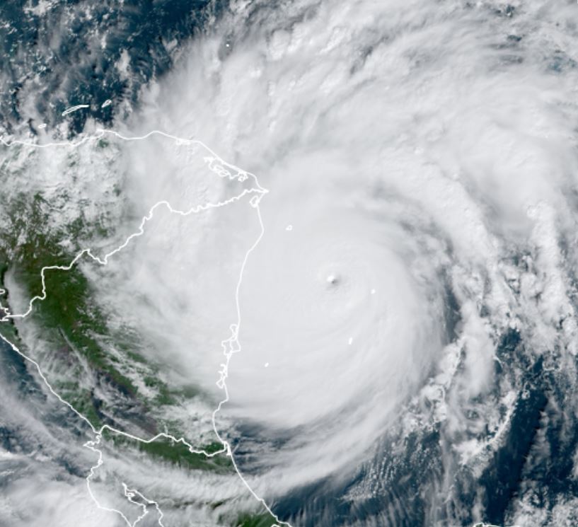
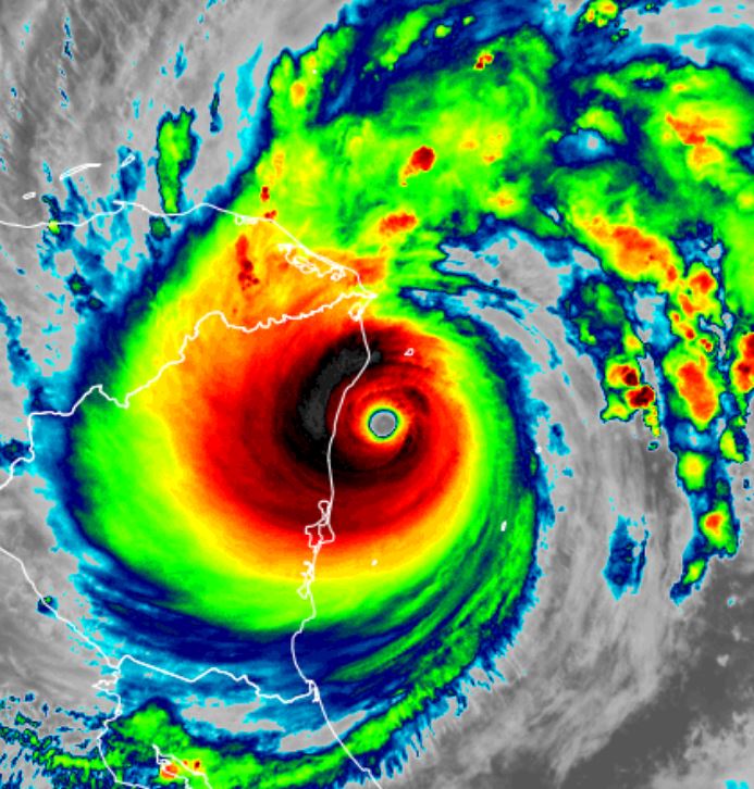
As of 7:00 AM EST Hurricane Iota was centered at 13.5 N / 81.6 W or about 145 miles SE of Cabo Gracias a Dios on the Nicaragua / Honduras border. It was moving west at 10 mph. Officially top sustained winds are estimated at 155 mph. Pressure was estimated at 925 hPa (mb).

Tropical Weather Forecast:
Iota will make landfall on the coast of Nicaragua this evening as a major hurricane - possibly cat 5.

Tropicast: Visible Satellite
Image

Tropicast: IR Satellite
Image
Rich Johnson
Twitter: https://twitter.com/richjohnsonwx
Certified Broadcast Meteorologist - Hurricane Expert
User avatar
Tropical Inspector
Site Admin
Site Admin
Posts: 3652
Joined: Tue Feb 20, 2007 2:28 pm
Antispam: no
Location: Under a palm tree
Contact:

Re: Iota

Post by Tropical Inspector »

Monday Morning Update

Iota now a top end cat 4

The Weather Situation
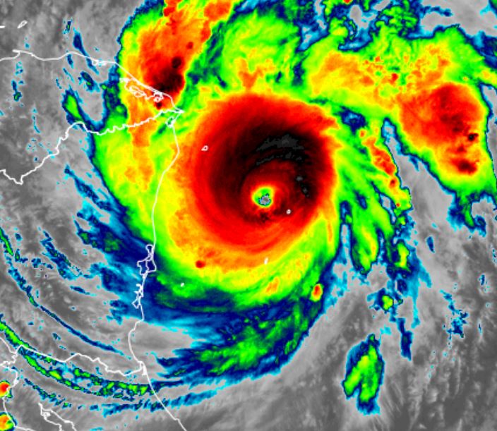
Iota is now a category 5 hurricane. Recon has continued to measure pressure falls indicating more strengthening. It has now become the latest category 5 hurricane on record, beating the Cuba hurricane of 1932 (November 8th). It is also the first Greek alphabet category five hurricane. Prior to this year only four category four or stronger hurricanes have made landfall in Nicaragua. This year there has been two. This is also the first time two major hurricanes have been recorded in November.

For more frequent updates: Twitter: https://twitter.com/richjohnsonwx

Current tropical weather
As of 10:00 AM EST Hurricane Iota was centered at 13.5 N / 82.0 W or about 100 miles ESE of Puerto Cabezas, Nicaragua. It was moving west at 9 mph. Officially top sustained winds are estimated at 160 mph. Pressure was estimated at 917 hPa (mb).

Tropical Weather Forecast:
Iota will make landfall on the coast of Nicaragua this evening. Expect catastrophic storm surge, wind damage and flooding rainfall.

Tropicast: Visible Satellite
Image
Rich Johnson
Twitter: https://twitter.com/richjohnsonwx
Certified Broadcast Meteorologist - Hurricane Expert
User avatar
Tropical Inspector
Site Admin
Site Admin
Posts: 3652
Joined: Tue Feb 20, 2007 2:28 pm
Antispam: no
Location: Under a palm tree
Contact:

Re: Iota

Post by Tropical Inspector »

Monday Evening Update

Iota about to make landfall

The Weather Situation
Iota was upgraded to cat 5 earlier today. It is about to make landfall. Catestrophic surge, winds and flooding rainfall will continue into the night.

For more frequent updates: Twitter: https://twitter.com/richjohnsonwx

Current tropical weather
As of 7:00 PM EST Hurricane Iota was centered at 13.6 N / 83.0 W or about 35 miles ESE of Puerto Cabezas, Nicaragua. It was moving west at 9 mph. Officially top sustained winds are estimated at 160 mph. Pressure was estimated at 918 hPa (mb).

Tropical Weather Forecast:
Iota will make landfall on the coast of Nicaragua this evening. Expect catastrophic storm surge, wind damage and flooding rainfall.

Tropicast: IR Satellite
Image
Rich Johnson
Twitter: https://twitter.com/richjohnsonwx
Certified Broadcast Meteorologist - Hurricane Expert
Post Reply

Return to “2020 Atlantic Hurricane Archives”

Who is online

Users browsing this forum: No registered users and 0 guests