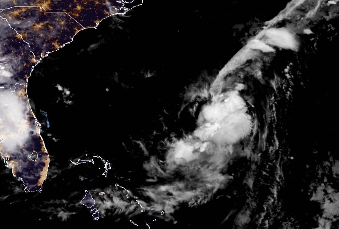
Monday Night Update
TD 6 struggling
The Weather Situation
TD 6 is fighting NW wind shear. The low level center is exposed. Some strengthening is possible as shear is expected to relax the next few days.
Current Tropical Weather
As of 11:00 PM AST TD 6 was centered at 31.5 N / 72.2 W or 320 miles SE of Cape Hatteras, NC. It was moving east at 3 mph. Top sustained winds are estimated at 35 mph. Pressure was estimated at 1010 MB.
Tropical Weather Forecast:
TD 6 should stay east of the U.S. east coast. Little effects are expected at this time.
Tropicast: IR Satellite August 26
Erin
- Tropical Inspector
- Site Admin
- Posts: 3581
- Joined: Tue Feb 20, 2007 2:28 pm
- Antispam: no
- Location: Under a palm tree
- Contact:
Erin
Rich Johnson
Twitter: https://twitter.com/richjohnsonwx
Certified Broadcast Meteorologist - Hurricane Expert
Twitter: https://twitter.com/richjohnsonwx
Certified Broadcast Meteorologist - Hurricane Expert
- Tropical Inspector
- Site Admin
- Posts: 3581
- Joined: Tue Feb 20, 2007 2:28 pm
- Antispam: no
- Location: Under a palm tree
- Contact:
Re: TD 6
Tuesday Evening Update
TD 6 still sheared
The Weather Situation
TD 6 has changed little since yesterday and is still battling wind shear.
Current Tropical Weather
As of 5:00 PM AST TD 6 was centered at 31.8 N / 71.8 W or 315 miles SE of Cape Hatteras, NC. It was moving NNW at 7 mph. Top sustained winds are estimated at 35 mph. Pressure was estimated at 1008 MB.
Tropical Weather Forecast:
TD 6 should stay east of the U.S. east coast. Little effects are expected at this time.
Tropicast: Visible Satellite Tuesday Afternoon
Rich Johnson
Twitter: https://twitter.com/richjohnsonwx
Certified Broadcast Meteorologist - Hurricane Expert
Twitter: https://twitter.com/richjohnsonwx
Certified Broadcast Meteorologist - Hurricane Expert
- Tropical Inspector
- Site Admin
- Posts: 3581
- Joined: Tue Feb 20, 2007 2:28 pm
- Antispam: no
- Location: Under a palm tree
- Contact:
Re: Erin
Wednesday Morning Update
Erin classified
The Weather Situation
Erin is in bad shape and probably shouldn't have been classified as a tropical storm.
Current Tropical Weather
As of 5:00 AM AST Erin was centered at 32.5 N / 72.4 W or 265 miles SE of Cape Hatteras, NC. It was moving NNW at 6 mph. Top sustained winds are estimated at 40 mph. Pressure was estimated at 1005 MB.
Tropical Weather Forecast:
Erin should stay east of the U.S. east coast. Little effects are expected at this time. NHC expects some strengthening, but I doubt anything significant if at all as the low is badly sheared.
Tropicast: Visible Satellite Wednesday Morning
Rich Johnson
Twitter: https://twitter.com/richjohnsonwx
Certified Broadcast Meteorologist - Hurricane Expert
Twitter: https://twitter.com/richjohnsonwx
Certified Broadcast Meteorologist - Hurricane Expert
- Tropical Inspector
- Site Admin
- Posts: 3581
- Joined: Tue Feb 20, 2007 2:28 pm
- Antispam: no
- Location: Under a palm tree
- Contact:
Re: Erin
Erin was downgraded at 11 AM edt to a tropical depression.
Rich Johnson
Twitter: https://twitter.com/richjohnsonwx
Certified Broadcast Meteorologist - Hurricane Expert
Twitter: https://twitter.com/richjohnsonwx
Certified Broadcast Meteorologist - Hurricane Expert
- Tropical Inspector
- Site Admin
- Posts: 3581
- Joined: Tue Feb 20, 2007 2:28 pm
- Antispam: no
- Location: Under a palm tree
- Contact:
Re: Erin
Tropicast: Visible Satellite Wednesday Night
Rich Johnson
Twitter: https://twitter.com/richjohnsonwx
Certified Broadcast Meteorologist - Hurricane Expert
Twitter: https://twitter.com/richjohnsonwx
Certified Broadcast Meteorologist - Hurricane Expert
Who is online
Users browsing this forum: No registered users and 42 guests