Page 1 of 1
Chris
Posted: Sat Jul 07, 2018 8:14 am
by Tropical Inspector
Saturday Morning Update
TD 3 east of the Carolinas
The Weather Situation
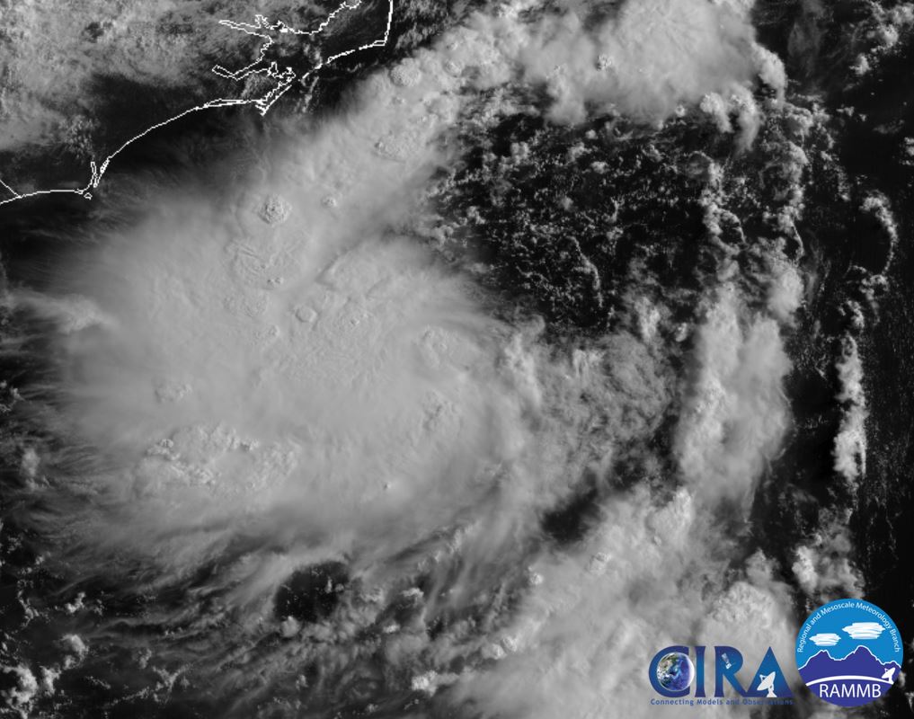
Tropical Depression 3 is over warm water east of the Carolinas. Deep convection is expanding and development is likely. At this point increasing surf and possibly some rainbands are the main threat to eastern North Carolina.
Current Tropical Weather
As of 5:00 AM EDT Tropical Depression 3 was centered at 33.2 N / 74.6 W or 145 miles SSE of Cape Hatteras, NC. It was moving NNW at 5 mph. Top sustained winds are estimated at 30 mph. Pressure was estimated at 1015 MB.
Tropical Weather Forecast:
TD 3 is forecast to strengthen and gradually move NE parallel offshore the US east coast. The main threat to the east coast will be increasing surf. Interests all the Mid Atlantic and New England coasts should monitor the situation for any changes.
Tropicast: Visible Satellite
Re: Tropical Depression 3
Posted: Sat Jul 07, 2018 3:40 pm
by Tropical Inspector
Saturday Evening Update
Little change today
The Weather Situation
Little change has occurred today. A few rainbands are between Cape Hatteras and Cape Lookout, North Carolina.
Current Tropical Weather
As of 5:00 PM EDT Tropical Depression 3 was centered at 32.9 N / 75.3 W or 160 miles south of Cape Hatteras, NC. It was stationary. Top sustained winds are estimated at 35 mph. Pressure was estimated at 1014 MB.
Tropical Weather Forecast:
TD 3 is forecast to strengthen and gradually move NE parallel well offshore the US east coast. The main threat to the east coast will be increasing surf. Interests all the Mid Atlantic and New England coasts should monitor the situation for any changes.
Tropicast: Visible Satellite
Re: Tropical Depression 3
Posted: Sun Jul 08, 2018 7:46 am
by Tropical Inspector
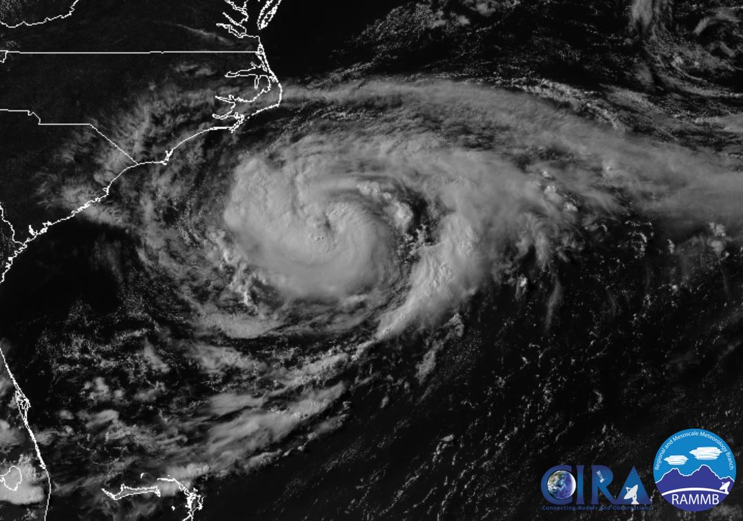
Sunday Morning Update
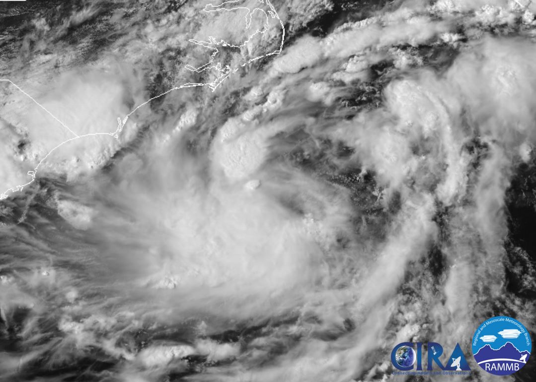
Chris organizing
The Weather Situation
An organized low level circulation is apparent this morning and deep convection is spreading from the SE to cover the circulation. Look for strengthening to continue today.
Current Tropical Weather
As of 5:00 AM EDT Tropical Depression 3 was centered at 33.0 N / 75.5 W or 150 miles south of Cape Hatteras, NC. It was stationary. Top sustained winds are estimated at 40 mph. Pressure was estimated at 1010 MB.
Tropical Weather Forecast:
Chris is forecast to strengthen and gradually move NE parallel well offshore the US east coast. The main threat to the east coast will be increasing surf. Interests all the Mid Atlantic and New England coasts should monitor the situation for any changes.
Tropicast: Visible Satellite
Re: Chris
Posted: Mon Jul 09, 2018 8:05 pm
by Tropical Inspector
Monday Evening Update
Chris almost a hurricane
The Weather Situation
Chris has steadily organized today. An eye is beginning to form. The showers and strong winds remain offshore of the coast of North Carolina.
Current Tropical Weather
As of 5:00 PM EDT Tropical Storm Chris was centered at 32.2 N / 74.4 W or 215 miles SSE of Cape Hatteras, NC. It was stationary. Top sustained winds are estimated at 70 mph. Pressure was estimated at 996 MB.
Tropical Weather Forecast:
Chris will move northeast and remain well east of the US east coast. It will gradually lose tropical characteristics around midweek as it moves over colder water as it approaches eastern Canada..
Tropicast: Visible Satellite
Re: Chris
Posted: Tue Jul 10, 2018 7:41 pm
by Tropical Inspector
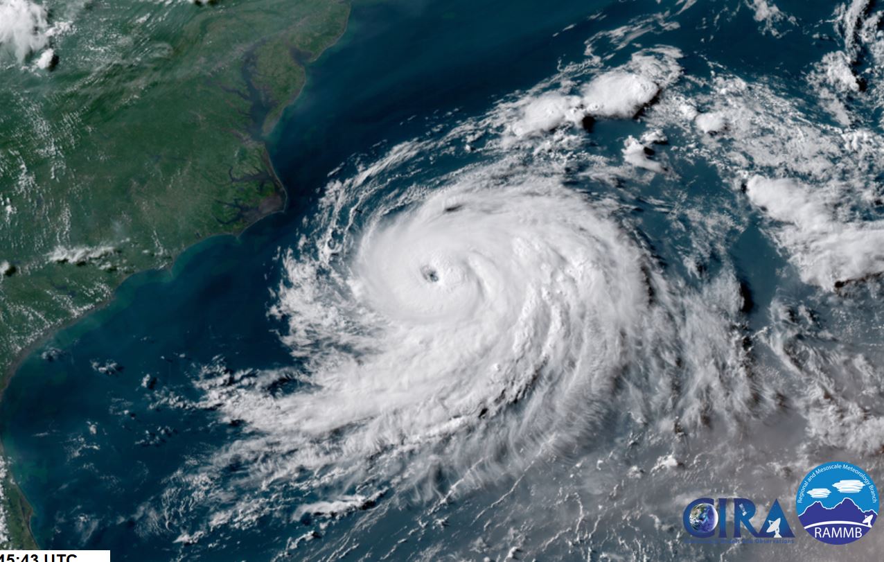
Tuesday Evening Update
Chris stronger, moving away
The Weather Situation
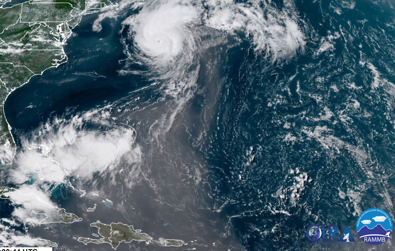
Chris became a hurricane (unofficially) around midday. It was officially classified at 5 pm edt after a reconnaissance confirmed it. Satellite shows an impressive eye and a symmetrical cdo. Further strengthening is likely before moving over colder water in the next 1-2 days.
Current Tropical Weather
As of 5:00 PM EDT Hurricane Chris was centered at 33.7 N / 72.4 W or 205 miles ESE of Cape Hatteras, NC. It was moving NE at 10 mph. Top sustained winds are estimated at 85 mph. Pressure was estimated at 980 MB.
Tropical Weather Forecast:
Chris will move northeast and remain well east of the US east coast. It will gradually lose tropical characteristics around midweek as it moves over colder water as it approaches eastern Canada.
Tropicast: Visible Satellite
Re: Chris
Posted: Wed Jul 11, 2018 7:14 am
by Tropical Inspector
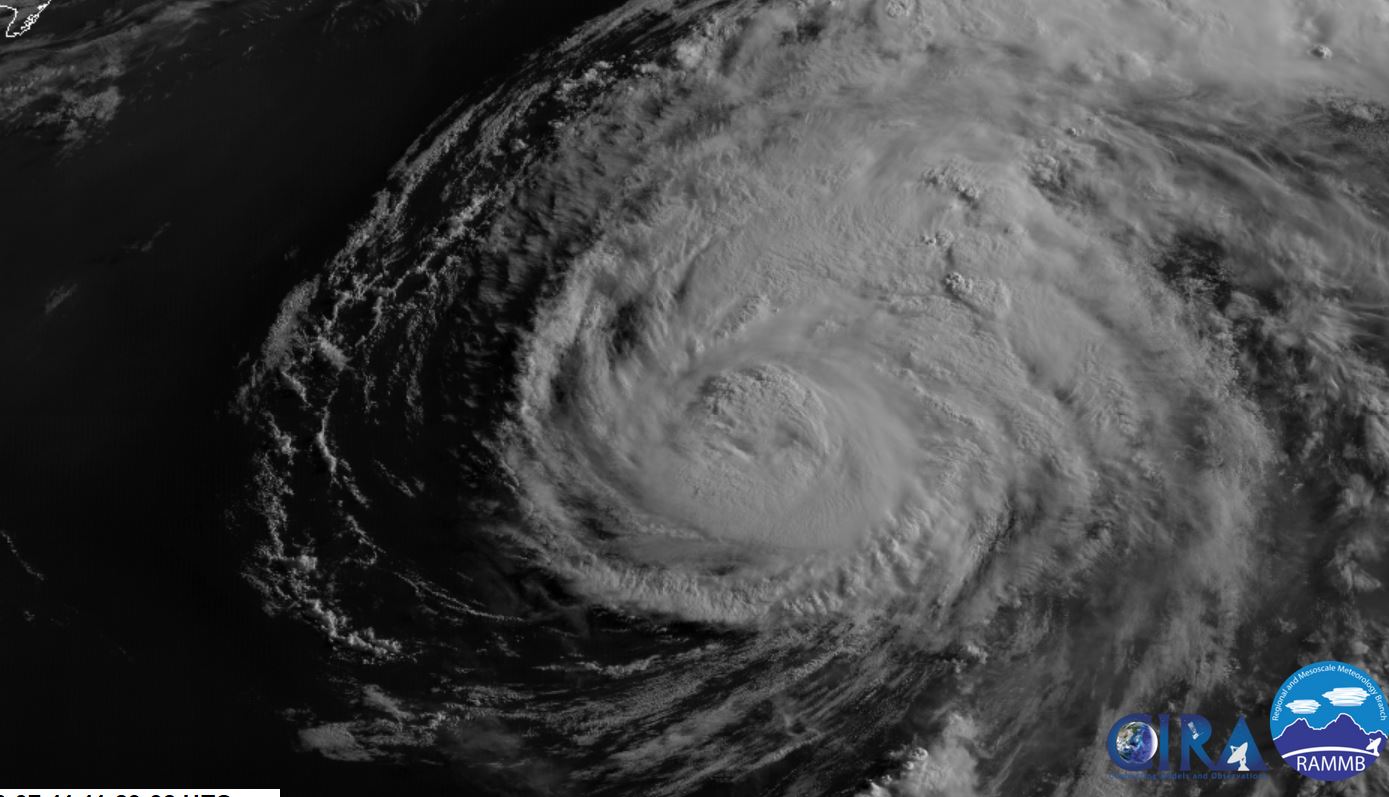
Wednesday Morning Update
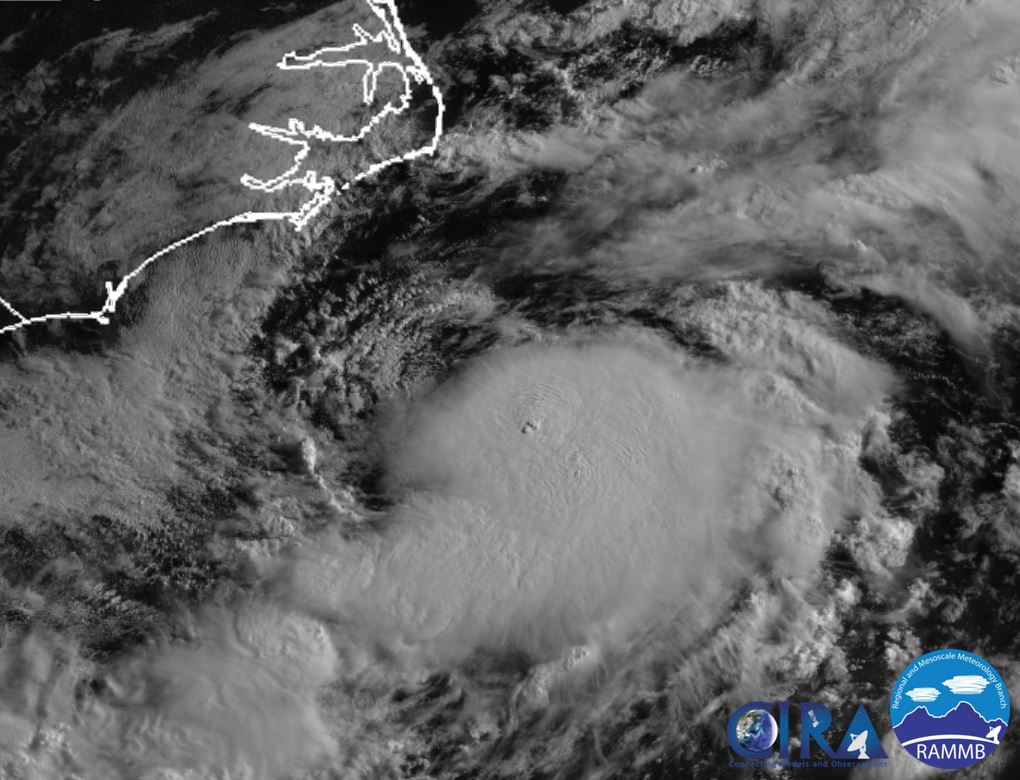
Chris maxing out
The Weather Situation
Chris may have peaked out in intensity this morning. The eye has now clouded over and Chris will start to become extratropical during the next 1-2 days.
Current Tropical Weather
As of 5:00 AM EDT Hurricane Chris was centered at 35.3 N / 69.9 W or 315 miles east of Cape Hatteras, NC. It was moving NE at 22 mph. Top sustained winds are estimated at 105 mph. Pressure was estimated at 970 MB.
Tropical Weather Forecast:
Chris will move northeast and remain well east of the US east coast. It will gradually lose tropical characteristics around midweek as it moves over colder water as it approaches eastern Canada.
Tropicast: Visible Satellite
Re: Chris
Posted: Wed Jul 11, 2018 7:41 pm
by Tropical Inspector
Wednesday Evening:
Chris is rapidly moving toward colder water and will be extratropical by tomorrow. Notice dust being entrained on the east side of the circulation.
Tropicast: Visible Satellite