|
|
Types of Weather
Weather type 1 - Clouds
There are four basic types of clouds. High clouds, middle clouds, low clouds, and clouds with vertical developement. There are also clouds that don't fall into any of these groups. Low clouds are from the surface to about 6,500 feet and are usually composed of water droplets unless temperatures are several degrees below freezing. Clouds on the ground are called fog. Middle clouds range from about 6,500 feet to about 20,0000 feet. They are also mostly composted of water droplets unless temperatures are cold. High clouds are above 20,000 feet and are composed of ice crystals. Click the link to get the whole story on clouds.
 
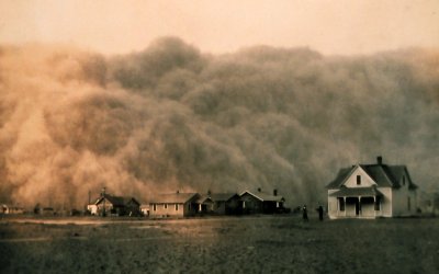
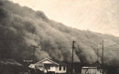
Weather type 2 - Dust Storm
Dust storms are created by winds moving across an arid region. Many times a strong dry cold front is the mechanism that creates the dust or sand storm. As strong winds move across an arid landscape, sand or dirt is picked up from the ground. Sometimes the lighter dust particles can be lifted up to 20,000 feet high into the atmosphere. A classic example of this is a sand and dust storm that develops over the Sahara desert. Easterly winds may carry the dust particles across the Atlantic ocean to the Caribbean Islands or Florida. Severe sand and dust storms can obscure visibility to zero and last for days. Picture courtesy of NOAA, George E. Marsh.
Weather type 3 - Fog
Fog is a stratus cloud on the ground. There are several types of fog. Advection fog is produced by a hortizontal motion of warm moist air over colder ground. An example of this would be a warm front moving across land with a recent snow or cold weather. Radiation fog is produced as heat from the earth surface is radiated back to space at night. A moist layer and nearly calm winds need to be present. Wind can mix in dryer air aloft, keeping the air below the saturation point. Steam fog forms when cold air moves over relatively warm water. This can be observed as wisps of "steam" rising from lakes, rivers or oceans when a cold air mass moves in. Upslope fog occurs as air is pushed up a mountainside and becomes saturated so that condensation occurs. Fog photographs courtesy of Rich Johnson and NOAA
 
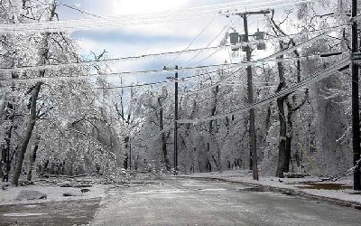
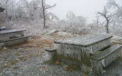
Weather type 4 - Freezing Rain / Ice
Freezing rain - known as "ice" occurs when a thin layer of freezing or below freezing air exists near the earth's surface. Typically this occurs when snow falls into warmer air changing the precipitation into rain. If a very thin layer of freezing air is present near the ground the rain will freeze on objects such as power lines, trees, and cars. Ice accumulations begin to cause serious problems when the ice is 1/2" or greater on objects. Freezing rain pictures courtesy of Nick Stefano.
Weather type 5 - Hail
The exact processes that creates hail are still being studied. Traditionally, textbooks showed hailstones being formed as a water droplet was carried aloft with an updaft into subfreezing air and freezing. As the ice moved into a downdraft, more water coated the hailstone. The cycle continued with the hailstone continuing to grow with each ride up and down the updraft and downdraft.
More recent studies suggest that super cooled water droplets are carried aloft by strong updrafts in thunderstorms. A small ice particle forms and grows as "waves" of supercooled water droplets continue to bump into the ice particle. A new coat of ice grows with each cycle. The hailstone is kept aloft by the strong updraft. The stronger the updraft the greater the force to keep the heavier hailstones aloft. The hailstone eventually falls to the grown when the the weight is too great for it to remain aloft or when it gets pushed out of the updraft. Sometimes hailstones bump into each other while being bombarded with supercooler water droplets and stick together giving the hailstone a spiked appearance.
The largest known hailstone fell on Vivian, South Dakota on July 23, 2010. The hail stone weighed 1.9 pounds and was eight inches in diameter. The previous record was from a storm on June 23, 2003 in Aurora, Nebraska and had a diameter of seven inches and weighed almost one pound. Another heavy hailstone fell in Coffeeville, Kansas on September 3, 1970. It weighed 1.7 pounds. Hail is considered severe when the diameter reaches one inch or quarter size. Hail photographs courtesy of NOAA and Jim Reed - jimreedphoto.com
 
Continue reading... More weather types.
Talk about weather on the weather message boards.
|
|
|
