|
|
Hurricane pictures / summaries 2008
Satellite images provided by NOAA / NASA / MODIS. Hurricane tracks courtesy of the National Hurricane Center.
 Click pictures for close up view Click pictures for close up view
|
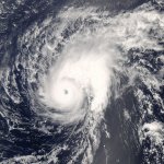
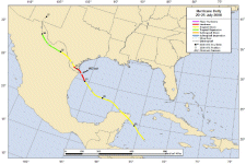
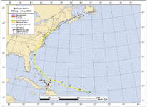
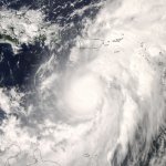
Hurricane Bertha
July 7, 2008
Hurricane Bertha formed just off of the coast of Africa and moved south of the Cape Verde Islands. It strengthened into a hurricane on July 7, the same day that
the hurricane Bertha of 1996 developed hurricane status. Bertha unwent rapid deepening and probably strengthened to about 125 mph before being sheared by southwesterly winds.
Two days later on July 9, Bertha strengthened rapidly again. Bertha moved north east of Bermuda and brought a wind gust to about 40-45 mph. It then stalled as it drifted east of Bermuda.
By July 22 it had become extratropical as it moved near Iceland.
|
|
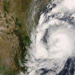
Hurricane Dolly
July 22, 2008
Hurricane Dolly began taking shape in the western Caribbean Sea. It gained tropical storm strength and it appeared that the center of the low would cross south of Cozumel.
The center was simply a weak area of low pressure. The center of circulation reorganized farther north near a mid level low pressure circualtion. With the low missing most of
the Yucatan Peninsula, it didn't weaken for long and Dolly became a hurricane just before landfall on South Padre Island. Top sustained winds were estimated to be 100 mph, but this
is doubtful since top gusts from anemometers only gusted to 75-80 mph. Rainfall totals north of Brownsville were in the 12-15" range which ended the drought in part of extreme
south Texas.
|
|
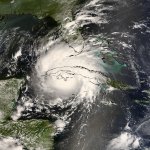
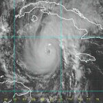
Hurricane Gustav
August 30, 2008
Hurricane Gustav started as a tropical disturbance over the central Caribbean Sea on August 25. Tropical depression 7 formed south of Hispaniola as
an "eyelike" feature appeared and was upgraded to Gustav shortly thereafter. Gustav became a minimal hurricane before making landfall on the southern peninsula of Haiti. Gustav
brought flooding rains again, not long after tropical storm Fay had flooded Haiti shortly before. Preliminary numbers indicate that 137 people lost their lives. Gustav moved southwest bringing its flooding rains to Jamaica then moved west. At this point it under went a rapid deepening phase and reached 150 mph just before landfall in western Cuba. The Cuban government reported a gust to 211 mph. Gutav never regained strength after crossing western Cuba. It was offically called 115 mph in the central Gulf, but observatons did not support that high a wind speed. The seas were high with a buoy measuring a wave height of 34 feet. The pressure was in the 950's range which is a category 3 strength. Wind observations as Gustav came onshore showed wind gusts mostly in the category 1 zone though. Gustav brought flooding rains to the Gulf coast and farther inland. Some totals were in the 20" range. Northern Louisiana and Arkansas were hit the worst. Tornadoes also were a problem and totaled at least 40.
|
|
Hurricane Hanna
September 1, 2008
Hurricane Hanna began as a disorganized area of showers and storms that began to quickly flare up about 250 miles northeast of the Leeward Islands. On Thursday, August 28 it was
classified as a tropical storm. At this point, Hanna began fighting westerly wind shear aloft. The wind shear nearly destroyed the circulation, but Hanna made a comback -
for a short while. Through Sunday, wind shear continued and once again Hanna looked very ragged. It resembled a subtropical storm more than tropical as it meandered east of
the Turks and Caicos. During Monday, Hanna organized and became a hurricane at 80 mph, as it continued to drift near the Turks and Caicos. Shortly after, Hanna weakened as it moved
to the south bringing more devatating flooding to Hispaniola, especially Haiti. Hanna weakened considerably as it sat just north of the Haiti coast. Wind current aloft changed and
Hanna once again started slowly started strengthening and moving north, just east of the Bahamas. Tropical storm Hanna paralleled the Florida coast about 200 miles to the east and brought beach erosion and some gusty winds. Hanna picked up speed and made landfall on the North Carolina / South Carolina border Saturday morning at 3:20 am. It stayed inland into southern Virginia and moved offshore of southern New Jersey and became extratropical as it headed to Nova Scotia. A track of heavy rain was produced from the coastal plain of North Carolina, northward into the southern Susquahanna valley and southern New England.
|

|
|
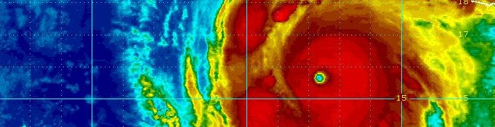
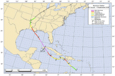
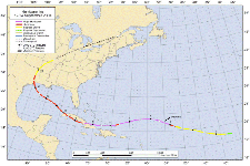
Hurricane Ike
September 4, 2008
Hurricane Ike began as a tropical wave off of the coast of Africa around August 29th. A few days later, by September 1 it had developed into the 9th tropical depression of the
hurricane season and was classified tropical storm Ike later in the day. Ike underwent rapid deepening on September 3rd into the morning of the 4th. It had achieved a category 4 strength on the
Saffir-Simpson scale at 140 mph. Shortly after this, northerly wind shear started to take its toll and weaken it north of the Leeward Islands.
Ike underwent another restrengthening phase as it moved west southwest into the Turks and Caicos and southern Bahamas. Grand Turk was in the northern eye wall and Great Inagua, Bahamas received a direct hit. Extensive damage occurred throughout these locations, with preliminary estimates showing 80% of the houses on Grand Turk receiving some damage. Ike continued toward Cuba making landfall on the northeast coast of Cuba. It crossed Cuba and turned more west northwest, barely off of its southern coast. After this, Ike made a second landfall in the western part of the country near where Hurricane Gustav made landfall not long before.
Ike began to strengthen immediately after moving into the southern Gulf of Mexico. The Keys received some flooding, had squally weather, and reported an isolated tornado. In a similar fashion to Hurricane Gustav, Hurricane Ike had a very low barometric pressure in the central Gulf of Mexico, but did not strengthen significantly. Dry air on the western side of the hurricane kept it from strengthening until just before landfall.
High storm tides flooded the upper Texas and southwest Louisiana coast twenty four hours ahead of landfall. Storm tides of 10-15 were common in these areas. Ike made landfall on September 13 at 2:10 am cdt at Galveston, TX. Even though Ike was classified as a category two hurricane with winds of 110 mph, very few gusts over 100 mph were recorded on land. Winds a few hundred feet above the ground were much higher though and damaged many windows to the sky scrapers in Houston. Rainfall totals of ten inches were reported in Houston. Heavy rain continued into the mid part of the U.S. as Ike merged with a cold front. Power was lost to approximately four and a half million people at the height of the hurricane. Damage estimates place Hurricane Ike as the 4th most costly U.S. hurricane at $18 billion.
|
|
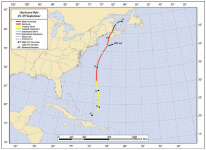
Hurricane Kyle
September 28, 2008
Hurricane Kyle began its life Saturday, September 20 south of Puerto Rico as a tropical disturbance. Over the next several days the disturbance meandered over and north of Puerto Rico, then drifted west, north of the Dominican Republic. At this point, upper air winds caused the disturbance to almost dissipate. A new center formed just southeast of the Dominican Republic and it looked like a depression formed. It produced tremendous rainfall during the four days it spent over Puerto Rico, the Virgin Islands, and eastern Dominican Republic. Rainfall totals over 30" were reported in southeast Puerto Rico. After this, the disturbance soon crossed land and weakened again.
The disturbance finally started to organize east of the Turks and Caicos and by September 25, the National Hurricane Center named it. Kyle started to pick up speed as it moved northward. It made landfall on the southwestern tip of Nova Scotia near Yarmouth Sunday evening. Bermuda picked up about 1 1/2" of rainfall and had winds gust to around tropical storm force. Cape Cod's rainfall measured genearlly 1-3" from Kyle, and Downeast Maine a 4-7" range.
One Buoy reported a sea of 36' as Kyle passed over. Although Kyle officially had top sustained winds of 80 mph at its strongest, there is little evidence that was this strong. Most buoys reported winds much weaker, with the strongest measuring a gust to 77 mph. Kyle will be remembered mostly for its destruction in Puerto Rico before it was even classified as a tropical depression.
|
|
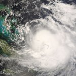
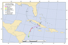
Hurricane Omar
October 15, 2008
Hurricane Omar began as a large mass of showers and storms in the eastern Caribbean Sea during the weekend of October 11-12. Heavy rain began over Puerto Rico, but abated as
a tropical disturbance slowly drifted south. A tropical depression formed a few hundred miles north of the Netherlands Antilles by Monday. Aruba, Bonaire and Curacao are only very rarely
affected by tropical storms or hurricanes as they are south of the normal hurricane track. A band of heavy showers and storms formed over the islands bringing rain that lasted for a few days. Not only was soaking rain reported, but southerly swell pounded the north coasts of the islands.
The twenty four hour period from Tuesday night to Wednesday night saw Omar go from being classified as a category 1 hurricane to a 125 mph category 3 hurricane. It started moving northeast toward the Virgin Islands and northern Leewards. Omar's hurricane force winds covered a small area, so that St. Croix didn't experience strong winds as it passed just east of the island. Omar continued east of the Virgin Islands overnight with strong winds causing some minor damage in the northern Leewards, as it passed to the west of Anquilla and St. Martin/St. Maarten Thursday morning. Strong upper air winds sheared Omar during the day Thursday to cause it to weaken rapidly and resemble more of a mid latitude system than hurricane.
Hurricane Omar will be remembered for being only the second "wrong way" hurricane in the Caribbean in recent memory. It moved southwest to northeast, as opposed to the more normal east to west motion that most hurricanes follow. The other was hurricane Lenny, another category 3 hurricane from 1999. Omar will also be remembered for mostly missing the northern islands of the Caribbean. The destructive winds of 125 mph winds only covered a small range and moved inbetween St. Croix and St. Martin/St. Maarten.
|
|
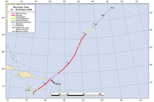
Hurricane Paloma
November 7, 2008
Paloma began as a weak low level spin in the southwest Caribbean sea on the tail end of the monsoon trough. After several days, it began to organize. The low was officially classified as a tropical depression on Novermber 5 just east of Nicaragua and Honduras. By Thursday, November 6, Paloma was a strengthening tropical storm. It was moving steadily northward and became a hurricane Thursday night. Hurricane Paloma showed steady strengthening all day Friday and was heading straight for Grand Cayman. It veered east of the island at the last couple of hours to allow the worst of the destructive winds to pass about 25 miles to the east. At the time, hurricane Paloma was at 120 mph. Grand Cayman actually suffered little damage as the core of hurricane force winds were very small.
During the night it appeared that Paloma would move near or just west of Little Cayman. It took a small jog east and moved barely east of Little Cayman and over Cayman Brac. Both of those islands suffered extensive roof damage and flooding. Hurricane Paloma was nearits top strength during its life cycle at 140 mph. It maxed out at 145 mph just northeast of the Cayman Islands. This would make it the second strongest November hurricane, behind Hurricane Lenny in 1999. Rainfall approached 10 inches in parts of the Cayman Islands.
Wind shear began taking its toll on Paloma as it approached the southern coast of Cuba. It made landfall officially at Santa Cruz Del Sur at 125 mph by Saturday evening. The wind shear totally stripped the convection from Paloma so that it weakened very rapidly over Cuba. By Sunday night it was no longer even a tropical depression.
|
Hurricane pictures and summaries main page.
|
|
|
|
|
)
)
)
)
)
)
)
)
)
)
)
)
)
)
)
)