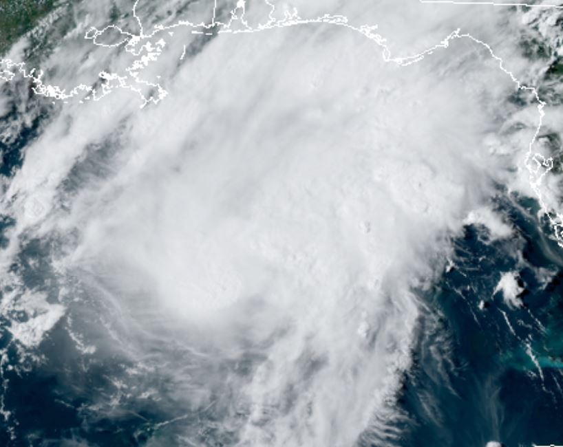
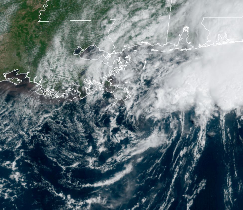
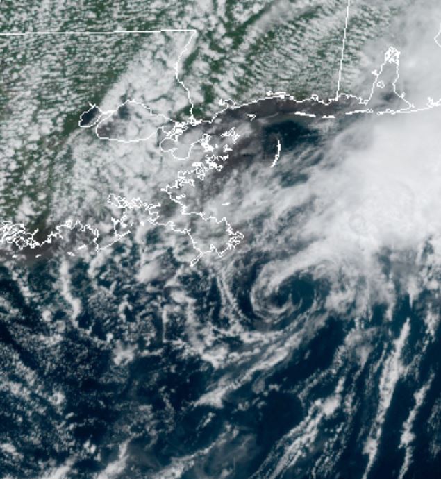
Marco

Tropical cyclone archives of the 2020 atlantic hurricane season
Post Reply
User avatar
Tropical Inspector
Site Admin
Site Admin
Posts: 3686
Joined: Tue Feb 20, 2007 2:28 pm
Antispam: no
Location: Under a palm tree
Contact:

Marco

Post by Tropical Inspector »

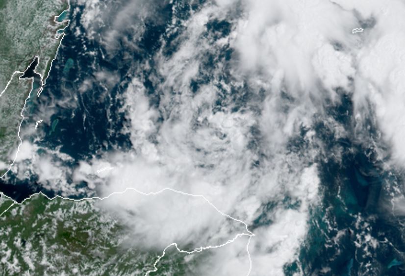
Thursday Midday Update

TD 14 organizing

The Weather Situation
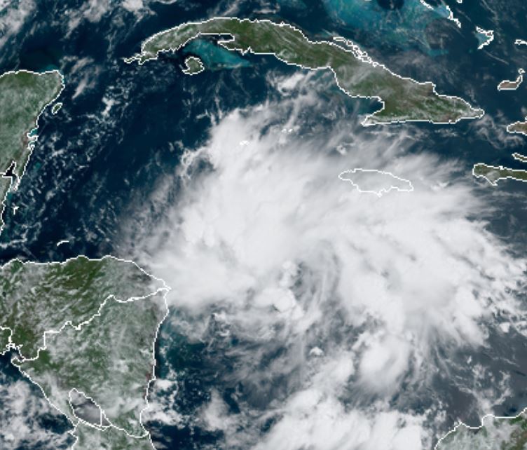
Satellite imagery shows td14 in a much more organized state. It would not be surprising to see it reach hurricane strength before reaching the Yucatan peninsula.

For more frequent updates: Twitter: https://twitter.com/richjohnsonwx

Current tropical weather
As of 11:00 AM AST TD 14 was centered at 15.1 N / 79.7 W or about 235 miles east of the Nicaragua / Honduras border. It was moving west 21 mph. Officially top sustained winds are estimated at 35 mph. Pressure was estimated at 1007 hPa (mb).

Tropical Weather Forecast:
TD 14 is predicted to strengthen as it approaches the Honduras coast then be pulled northwest as it then approaches the Yucatan during Saturday. It is possible that it could reach hurricane strength before landfall. After weakening over the Yucatan, it will restrengthen over the western Gulf of Mexico. It is likely going to battle wind shear as it approaches the northwestern Gulf coast, so strengthening will be limited.

Tropicast: Visible Satellite
Image
Rich Johnson
Twitter: https://twitter.com/richjohnsonwx
Certified Broadcast Meteorologist - Hurricane Expert
User avatar
Tropical Inspector
Site Admin
Site Admin
Posts: 3686
Joined: Tue Feb 20, 2007 2:28 pm
Antispam: no
Location: Under a palm tree
Contact:

Re: TD 14

Post by Tropical Inspector »

Friday Midday Update

TD 14 north of Honduras

The Weather Situation
Satellite imagery shows td 14 with an exposed low level center north of Honduras. The strongest convection is actually well away from the center of the circulation.

For more frequent updates: Twitter: https://twitter.com/richjohnsonwx

Current tropical weather
As of 11:00 AM EDT TD 14 was centered at 16.6 N / 84.1 W or about 325 miles SE of Cozumel, Mexico. It was moving NW 14 mph. Officially top sustained winds are estimated at 35 mph. Pressure was estimated at 1008 hPa (mb).

Tropical Weather Forecast:
TD 14 is predicted to strengthen as it approaches approaches the Yucatan during tomorrow. It is possible that it could reach hurricane strength before landfall. After weakening over the Yucatan, it will restrengthen over the western Gulf of Mexico. It is likely going to battle wind shear as it approaches the northwestern Gulf coast, so strengthening will be limited.

Tropicast: Visible Satellite
Image
Rich Johnson
Twitter: https://twitter.com/richjohnsonwx
Certified Broadcast Meteorologist - Hurricane Expert
User avatar
Tropical Inspector
Site Admin
Site Admin
Posts: 3686
Joined: Tue Feb 20, 2007 2:28 pm
Antispam: no
Location: Under a palm tree
Contact:

Marco

Post by Tropical Inspector »

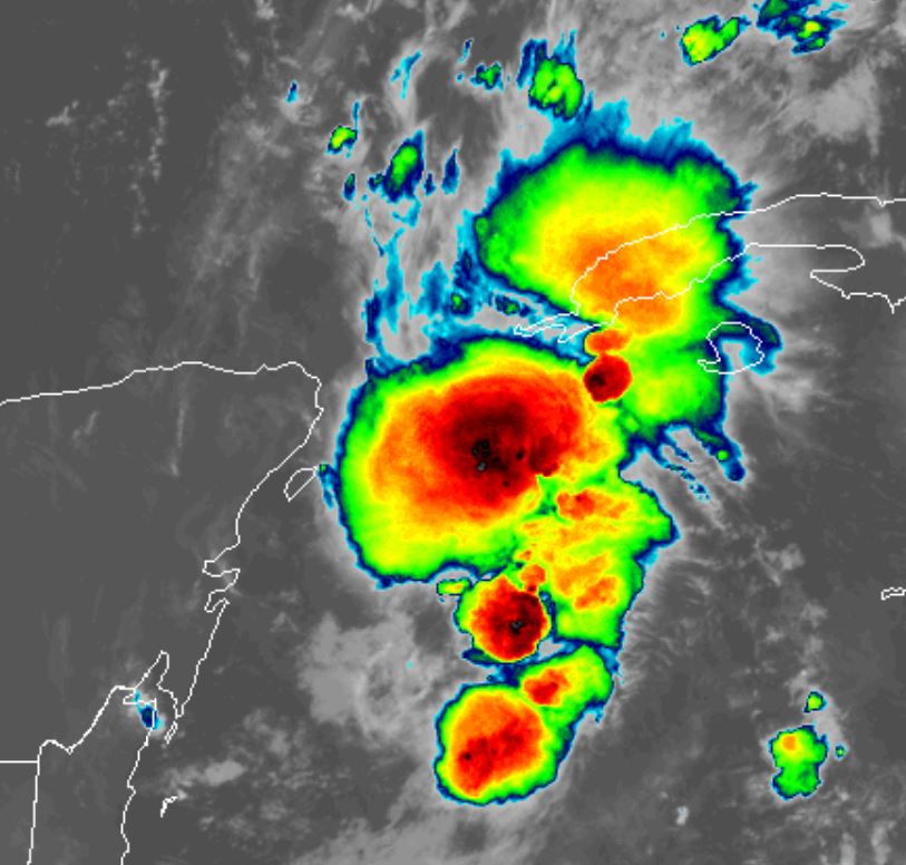
Saturday Morning Update

Marco near the Yucatan

The Weather Situation
The recon has found Marco stronger this morning, despite the limited convection. Marco will move into the southern Gulf later today where some strengthening is possible. Wind shear should develop over the next couple of days.

For more frequent updates: Twitter: https://twitter.com/richjohnsonwx

Current tropical weather
As of 7:00 AM CDT Marco was centered at 20.2 N / 85.2 W or about 110 miles east of Cozumel, Mexico. It was moving NNW 12 mph. Officially top sustained winds are estimated at 50 mph. Pressure was estimated at 1002 hPa (mb).

Tropical Weather Forecast:
Marco looks to barely miss the Yucatan peninsula to the east today. It will then move north in response to an upper air trough. It will then turn west toward the NW Gulf coast as the subtropical ridge builds in again by Tuesday.

Tropicast: IR Satellite
Image
Rich Johnson
Twitter: https://twitter.com/richjohnsonwx
Certified Broadcast Meteorologist - Hurricane Expert
User avatar
Tropical Inspector
Site Admin
Site Admin
Posts: 3686
Joined: Tue Feb 20, 2007 2:28 pm
Antispam: no
Location: Under a palm tree
Contact:

Re: Marco

Post by Tropical Inspector »

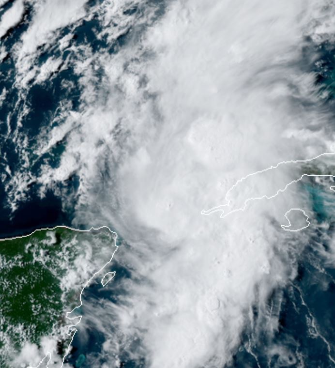
Saturday Evening Update

Marco strengthening

The Weather Situation
Convection is now increasing as Marco is moving into the southern Gulf of Mexico. Additional strengthening is likely until Marco approaches the Louisiana coast. Wind shear will cap off the strengthening or start weakening near landfall.

For more frequent updates: Twitter: https://twitter.com/richjohnsonwx

Current tropical weather
As of 4:00 PM CDT Marco was centered at 21.9 N / 85.7 W or about 540 miles SSE of the Mouth of the Mississippi river. It was moving NNW 13 mph. Officially top sustained winds are estimated at 65 mph. Pressure was estimated at 9922 hPa (mb).

Tropical Weather Forecast:
Marco forecast has changed significantly. It is now forecast to hit the northern Gulf Coast Monday as a minimal hurricane. The forecast shift will be delayed until after landfall.

Tropicast: Visible Satellite
Image
Rich Johnson
Twitter: https://twitter.com/richjohnsonwx
Certified Broadcast Meteorologist - Hurricane Expert
User avatar
Tropical Inspector
Site Admin
Site Admin
Posts: 3686
Joined: Tue Feb 20, 2007 2:28 pm
Antispam: no
Location: Under a palm tree
Contact:

Re: Marco

Post by Tropical Inspector »

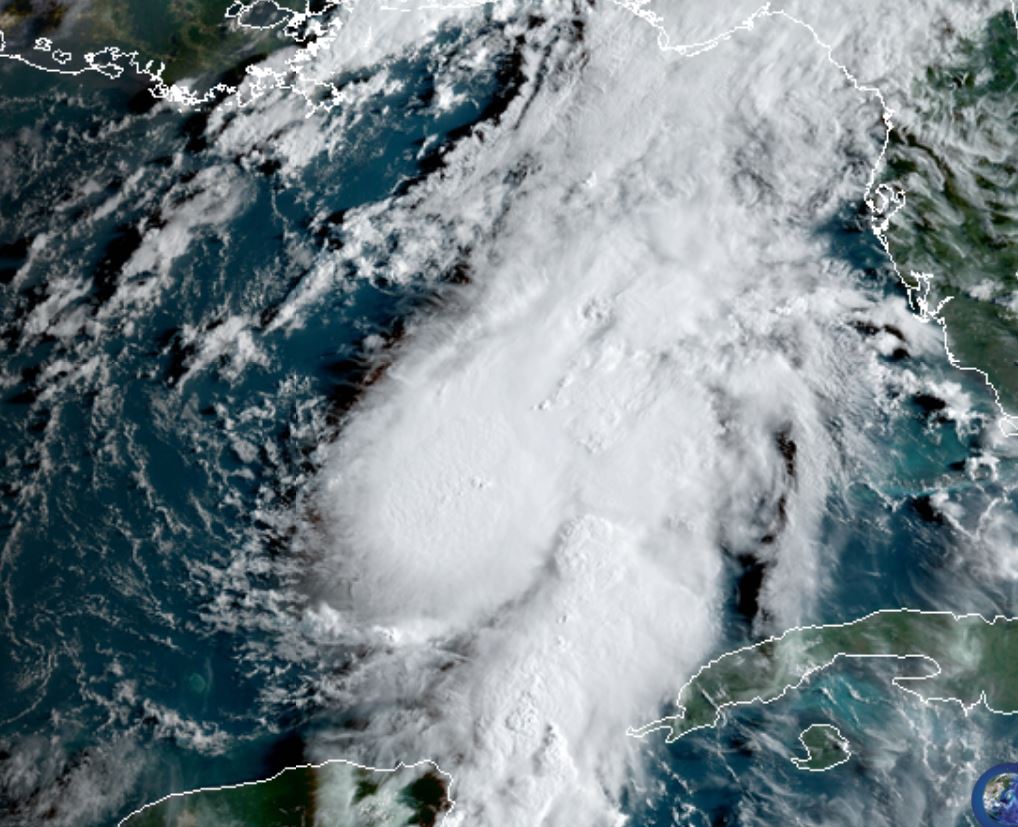
Sunday Morning Update

Marco being sheared

The Weather Situation
Southwesterly wind shear has made Marco lopsided. Deep convection is mainly on the eastern side of the circulation. A recon found a SFMR reading of 60 kts, that's why NHC increased windspeed to 70 mph.

For more frequent updates: Twitter: https://twitter.com/richjohnsonwx

Current tropical weather
As of 7:00 AM CDT Marco was centered at 24.2 N / 87.1 W or about 360 miles SSE of the Mouth of the Mississippi river. It was moving NNW 13 mph. Officially top sustained winds are estimated at 70 mph. Pressure was estimated at 993 hPa (mb).

Tropical Weather Forecast:
Marco forecast is forecast to hit the northern Gulf Coast Monday as a minimal hurricane. The main effects of heavy rainfall, gusty winds and surge will be near and east of the center of landfall.

Tropicast: Visible Satellite
Image
Rich Johnson
Twitter: https://twitter.com/richjohnsonwx
Certified Broadcast Meteorologist - Hurricane Expert
User avatar
Tropical Inspector
Site Admin
Site Admin
Posts: 3686
Joined: Tue Feb 20, 2007 2:28 pm
Antispam: no
Location: Under a palm tree
Contact:

Re: Marco

Post by Tropical Inspector »

Sunday Evening Update

Marco upgraded

The Weather Situation
Marco is a minimal hurricane is deep convection near the center and east of the circulation. Heavy rainfall, storm surge and winds to tropical storm force can be expected near and east of the center as it approaches the Gulf coast. Forecast models have shifted.... again. See info below.

For more frequent updates: Twitter: https://twitter.com/richjohnsonwx

Current tropical weather
As of 4:00 PM CDT Marco was centered at 25.8 N / 87.8 W or about 395 miles SE of Lafayette, LA. It was moving NNW 13 mph. Officially top sustained winds are estimated at 75 mph. Pressure was estimated at 991 hPa (mb).

Tropical Weather Forecast:
Marco is now forecast to move more west - again. Instead of moving into the SE Louisiana coast Monday, it is now forecast to brush the coast and move westward. Wind shear should keep Marco as a minimal hurricane.

Tropicast: Visible Satellite
Image
Rich Johnson
Twitter: https://twitter.com/richjohnsonwx
Certified Broadcast Meteorologist - Hurricane Expert
User avatar
Tropical Inspector
Site Admin
Site Admin
Posts: 3686
Joined: Tue Feb 20, 2007 2:28 pm
Antispam: no
Location: Under a palm tree
Contact:

Re: Marco

Post by Tropical Inspector »

Monday Morning Update

Marco sheared

The Weather Situation
Per our update on twitter last night.... It became very apparent that Marco was no longer a hurricane. Wind shear continues to tear the tropical cyclone apart. The only deep convection remains well northeast of the center.

For more frequent updates: Twitter: https://twitter.com/richjohnsonwx

Current tropical weather
As of 7:00 AM CDT Marco was centered at 28.1 N / 88.4 W or about 85 miles SE of the Mouth of the Mississippi River. It was moving NW 10 mph. Officially top sustained winds are estimated at 50 mph. Pressure was estimated at 1005 hPa (mb).

Tropical Weather Forecast:
Strong windshear has greatly weakened Marco. It will now drift NW, then west along the coast of Louisiana and dissipate over the next 24-36 hours.

Tropicast: Visible Satellite
Image
Rich Johnson
Twitter: https://twitter.com/richjohnsonwx
Certified Broadcast Meteorologist - Hurricane Expert
User avatar
Tropical Inspector
Site Admin
Site Admin
Posts: 3686
Joined: Tue Feb 20, 2007 2:28 pm
Antispam: no
Location: Under a palm tree
Contact:

Re: Marco

Post by Tropical Inspector »

Monday Afternoon Update

Marco weak

The Weather Situation
Marco does not look like a tropical storm any longer. Personally, I would go with tropical depression on its way to dissipation

For more frequent updates: Twitter: https://twitter.com/richjohnsonwx

Current tropical weather
As of 1:00 PM CDT Marco was centered at 28.7 N / 88.6 W or about 40 miles SE of the Mouth of the Mississippi River. It was moving NW 6 mph. Officially top sustained winds are estimated at 40 mph. Pressure was estimated at 1006 hPa (mb).

Tropical Weather Forecast:
Marco will dissipate soon near southern Louisiana.

Tropicast: Visible Satellite
Image
Rich Johnson
Twitter: https://twitter.com/richjohnsonwx
Certified Broadcast Meteorologist - Hurricane Expert
Post Reply

Return to “2020 Atlantic Hurricane Archives”

Who is online

Users browsing this forum: No registered users and 0 guests