Sunday Afternoon Update
Tropical Depression 8 forms
The Weather Situation
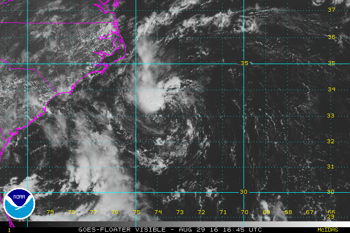
An upper air low well east of North Carolina the past few days and has gained tropical characteristics. A well defined low center is now being exposed by easterly wind shear. It is possible that this system was a minimal tropical storm earlier this morning.
Current Tropical Weather
As of 11 AM AST Tropical Depression 8 was centered at 31.5 N / 70.0 W or 405 miles southeast of Cape Hatteras, North Carolina. It was moving west at 9 mph. Top sustained winds are estimated at 35 mph. Pressure was estimated at 1009 mb.
Tropical Weather Forecast:
Forecasts take TD 8 west toward the coast of NC. It will be about 100 miles east of Morehead City by Tuesday morning. Continued wind shear should inhibit strengthening, but tropical storm strength is probable.
Tropicast: Visible Satellite
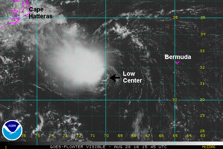
Tropical Depression 8
Moderator: Florida Beach Gal
- Tropical Inspector
- Site Admin
- Posts: 3686
- Joined: Tue Feb 20, 2007 2:28 pm
- Antispam: no
- Location: Under a palm tree
- Contact:
Tropical Depression 8
Rich Johnson
Twitter: https://twitter.com/richjohnsonwx
Certified Broadcast Meteorologist - Hurricane Expert
Twitter: https://twitter.com/richjohnsonwx
Certified Broadcast Meteorologist - Hurricane Expert
- Tropical Inspector
- Site Admin
- Posts: 3686
- Joined: Tue Feb 20, 2007 2:28 pm
- Antispam: no
- Location: Under a palm tree
- Contact:
Re: Tropical Depression 8
Monday Afternoon Update
Tropical Depression 8 still sheared
The Weather Situation
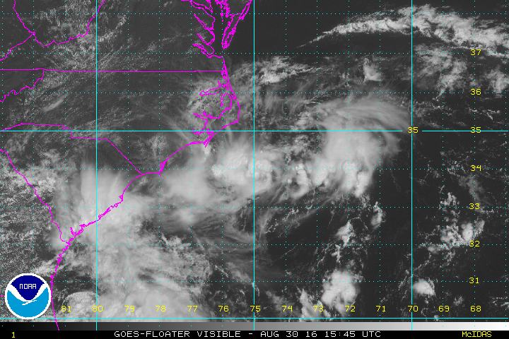
A strong low pressure center aloft SW of tropical depression 8 coupled with high pressure to the north has created shearing winds. Nearly all convection was stripped away Sunday. Some convection has rebuilt today on the northwestern side of the circulation. A few rain squalls may affect the Outer Banks over the next 24 hours.
Current Tropical Weather
As of 11 AM AST Tropical Depression 8 was centered at 33.2 N / 73.5 W or 180 miles southeast of Cape Hatteras, North Carolina. It was moving NW at 7 mph. Top sustained winds are estimated at 35 mph. Pressure was estimated at 1011 mb.
Tropical Weather Forecast:
Tropical Depression 8 is recurving and should be just east of Cape Hatteras tomorrow afternoon. Minimal impacts are expected to eastern North Carolina. TD 8 may strengthen into a minimal tropical storm during the next 24 hours.
Tropicast: Visible Satellite
Rich Johnson
Twitter: https://twitter.com/richjohnsonwx
Certified Broadcast Meteorologist - Hurricane Expert
Twitter: https://twitter.com/richjohnsonwx
Certified Broadcast Meteorologist - Hurricane Expert
- Tropical Inspector
- Site Admin
- Posts: 3686
- Joined: Tue Feb 20, 2007 2:28 pm
- Antispam: no
- Location: Under a palm tree
- Contact:
Re: Tropical Depression 8
Tuesday Afternoon Update
Tropical Depression 8 remains disorganized
The Weather Situation
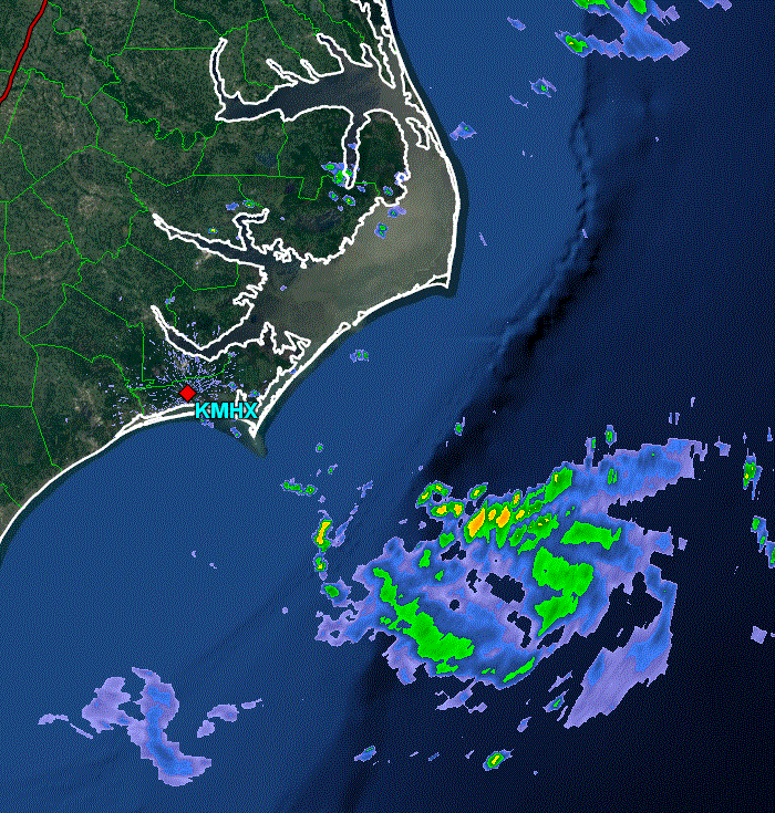
Tropical depression remains disorganized. A ball of convection associated with the center of TD 8 is south of Cape Hatteras. Radar shows a well defined circulation. A low level swirl is also apparent approximately 100 miles northeast of the main center. Effects of eastern North Carolina will be minimal. Higher than normal surf will be the main impact.
Current Tropical Weather
As of 11 AM AST Tropical Depression 8 was centered at 34.2 N / 75.3 W or 70 miles south of Cape Hatteras, North Carolina. It was moving NNW at 5 mph. Top sustained winds are estimated at 35 mph. Pressure was estimated at 1011 mb.
Tropical Weather Forecast:
Tropical depression 8 still may organize into a tropical storm as it pulls away from the mid atlantic coast the next few days.
Tropicast: Visible Satellite
Tropicast: Eastern North Carolina Radar
Rich Johnson
Twitter: https://twitter.com/richjohnsonwx
Certified Broadcast Meteorologist - Hurricane Expert
Twitter: https://twitter.com/richjohnsonwx
Certified Broadcast Meteorologist - Hurricane Expert
- Tropical Inspector
- Site Admin
- Posts: 3686
- Joined: Tue Feb 20, 2007 2:28 pm
- Antispam: no
- Location: Under a palm tree
- Contact:
Re: Tropical Depression 8
Wednesday Afternoon Update
Tropical Depression 8 still disorganized
The Weather Situation
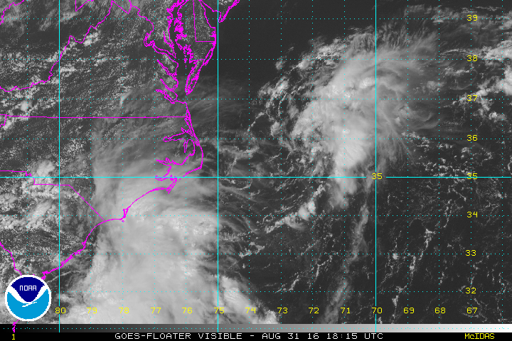
Tropical depression remains disorganized. The center is totally exposed and it is possible that TD 8 will not become a tropical storm.
Current Tropical Weather
As of 2 PM AST Tropical Depression 8 was centered at 35.8 N / 72.6 W or 185 miles ENE of Cape Hatteras, North Carolina. It was moving NE at 15 mph. Top sustained winds are estimated at 35 mph. Pressure was estimated at 1010 mb.
Tropical Weather Forecast:
Tropical depression 8 is moving away from North Carolina off of the Mid Atlantic coast.
Tropicast: Visible Satellite
Rich Johnson
Twitter: https://twitter.com/richjohnsonwx
Certified Broadcast Meteorologist - Hurricane Expert
Twitter: https://twitter.com/richjohnsonwx
Certified Broadcast Meteorologist - Hurricane Expert
- Tropical Inspector
- Site Admin
- Posts: 3686
- Joined: Tue Feb 20, 2007 2:28 pm
- Antispam: no
- Location: Under a palm tree
- Contact:
Re: Tropical Depression 8
Tropical Depression 8 was officially declared dissipated by NHC at 5 am EDT.
Rich Johnson
Twitter: https://twitter.com/richjohnsonwx
Certified Broadcast Meteorologist - Hurricane Expert
Twitter: https://twitter.com/richjohnsonwx
Certified Broadcast Meteorologist - Hurricane Expert
Who is online
Users browsing this forum: No registered users and 0 guests