Page 1 of 1
Rafael
Posted: Tue Nov 05, 2024 5:46 am
by Tropical Inspector
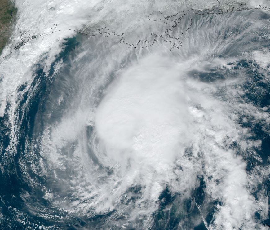
Tuesday Morning Update
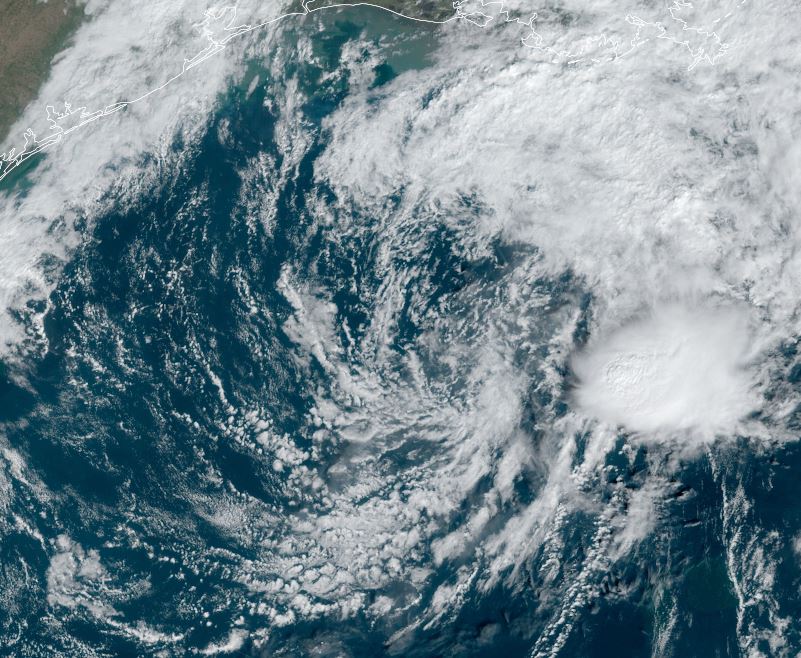
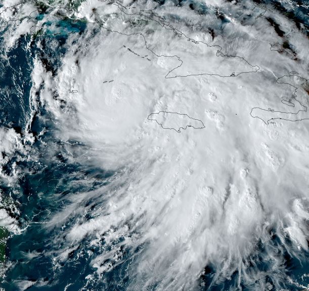
Rafael moving toward Jamaica
Rafael was named a tropical storm late Sunday afternoon and slowly organized on Monday. Early today banding is taking shape as well as increased convection. Very heavy rainfall will increase across Jamaica today.
The Weather Situation
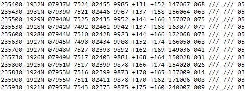
SUMMARY OF 400 AM EST...0900 UTC...INFORMATION
----------------------------------------------
LOCATION...17.0N 78.0W
ABOUT 105 MI...170 KM SW OF KINGSTON JAMAICA
ABOUT 265 MI...425 KM SE OF GRAND CAYMAN
MAXIMUM SUSTAINED WINDS...60 MPH...95 KM/H
PRESENT MOVEMENT...NW OR 325 DEGREES AT 13 MPH...20 KM/H
MINIMUM CENTRAL PRESSURE...993 MB...29.33 INCHES
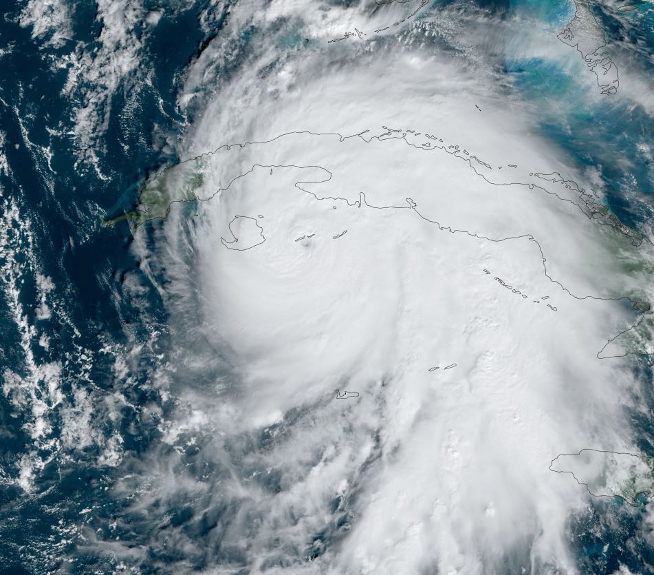
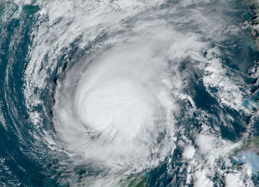
Tropicast: Visible Satellite RAMMB / CIRA Slider Tuesday Early Morning
 Tropicast: Visible Satellite RAMMB / CIRA Slider Monday Afternoon
 Tropical Weather Forecast:
The center of Rafael will move near or a bit west of western Jamaica soon. Very heavy rainfall is east of the center and will produce flash flooding. It will track over the Cayman Islands this evening before crossing western Cuba as a hurricane on Wednesday then into the central Gulf of Mexico. It appears that Rafael will weaken as it moves toward the northern Gulf later this week..... Please keep advised as changes are always possible.
Re: Rafael
Posted: Tue Nov 05, 2024 8:15 pm
by Tropical Inspector
Tuesday Evening Update
Rafael now a hurricane
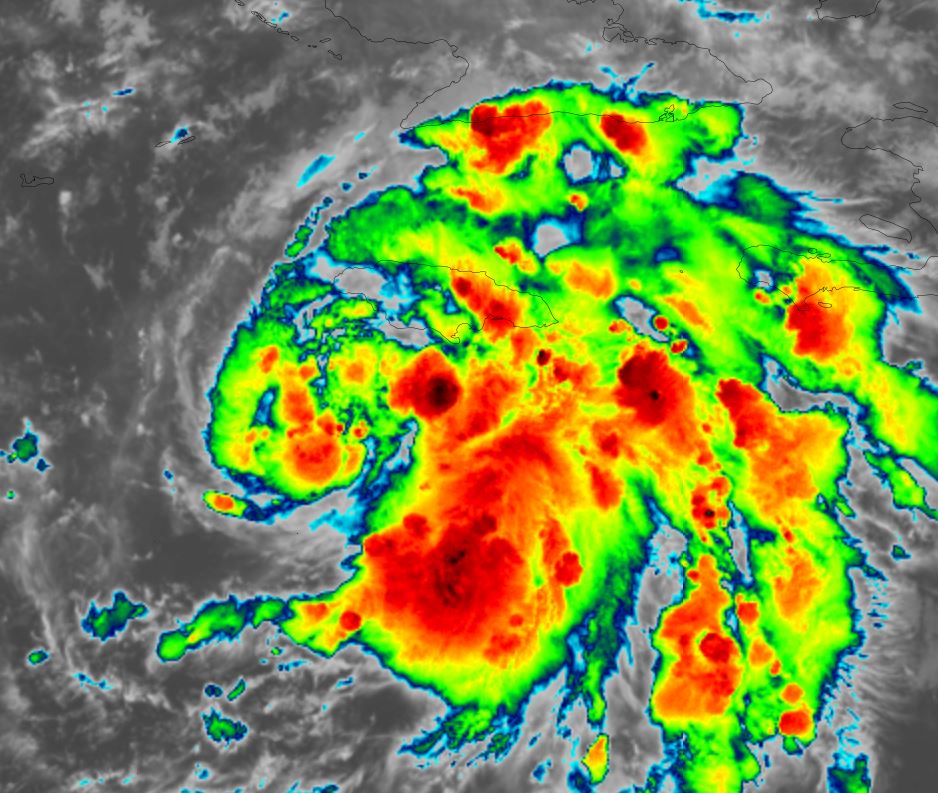
Rafael became a hurricane near the Cayman Islands this evening as hurricane hunter aircraft found increasing winds. The core is now passing west of Little Cayman with the strongest winds now bypassing the Islands.
The Weather Situation
SUMMARY OF 720 PM EST...0020 UTC...INFORMATION
---------------------------------------------------
LOCATION...19.4N 79.9W
ABOUT 20 MI...35 KM SE OF LITTLE CAYMAN
ABOUT 305 MI...495 KM SSE OF HAVANA CUBA
MAXIMUM SUSTAINED WINDS...75 MPH...120 KM/H
PRESENT MOVEMENT...NW OR 325 DEGREES AT 15 MPH...24 KM/H
MINIMUM CENTRAL PRESSURE...986 MB...29.11 INCHES
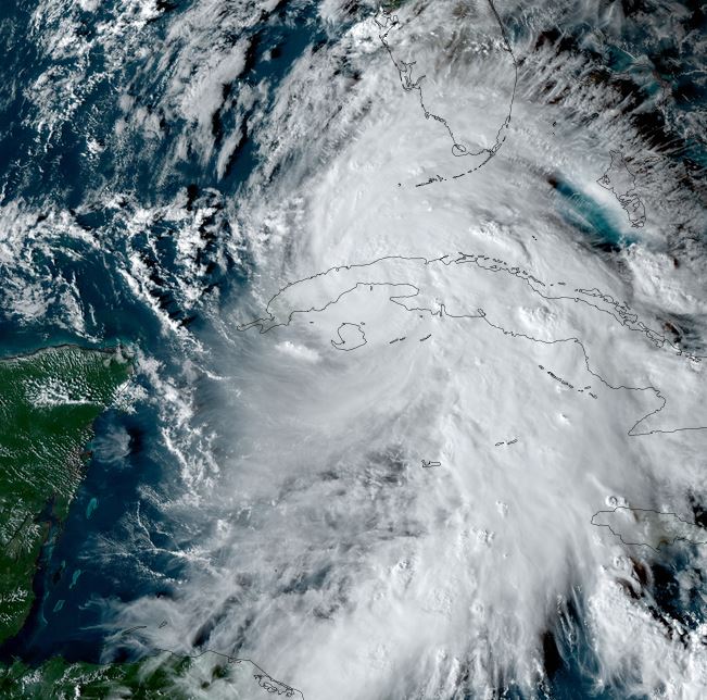
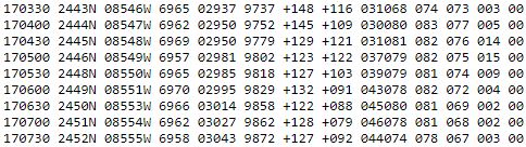
Tropicast: Visible Satellite RAMMB / CIRA Slider Tuesday Late Afternoon
 Tropicast: Hurricane Hunter Recon Report Tuesday Evening
 Tropical Weather Forecast:
The center of Rafael is moving away from the Cayman Islands with the core currently west of Little Cayman. It will cross western Cuba as a hurricane on Wednesday then into the central Gulf of Mexico. It appears that Rafael will weaken as it moves toward the northern Gulf later this week..... Please keep advised as changes are always possible.
Re: Rafael
Posted: Wed Nov 06, 2024 6:39 pm
by Tropical Inspector
Wednesday Evening Update
Rafael moving into the Gulf
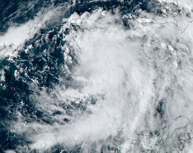
Rafael Was estimated at 115 mph before making landfall a few hours over western Cuba. It is now entering the southeastern Gulf of Mexico. Havana reported a wind gust to 67 mph recently.
The Weather Situation
SUMMARY OF 600 PM EST...2300 UTC...INFORMATION
----------------------------------------------
LOCATION...23.0N 83.0W
ABOUT 40 MI...65 KM W OF HAVANA CUBA
ABOUT 15 MI...25 KM ENE OF BAHIA HONDA CUBA
MAXIMUM SUSTAINED WINDS...105 MPH...170 KM/H
PRESENT MOVEMENT...NW OR 320 DEGREES AT 14 MPH...22 KM/H
MINIMUM CENTRAL PRESSURE...962 MB...28.41 INCHES
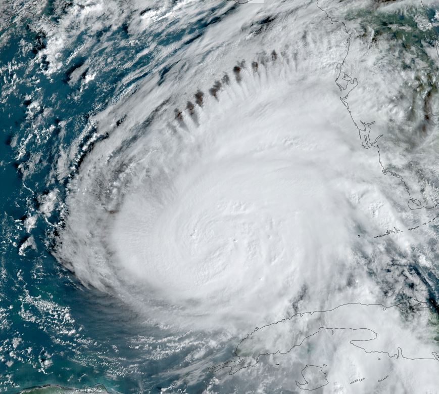
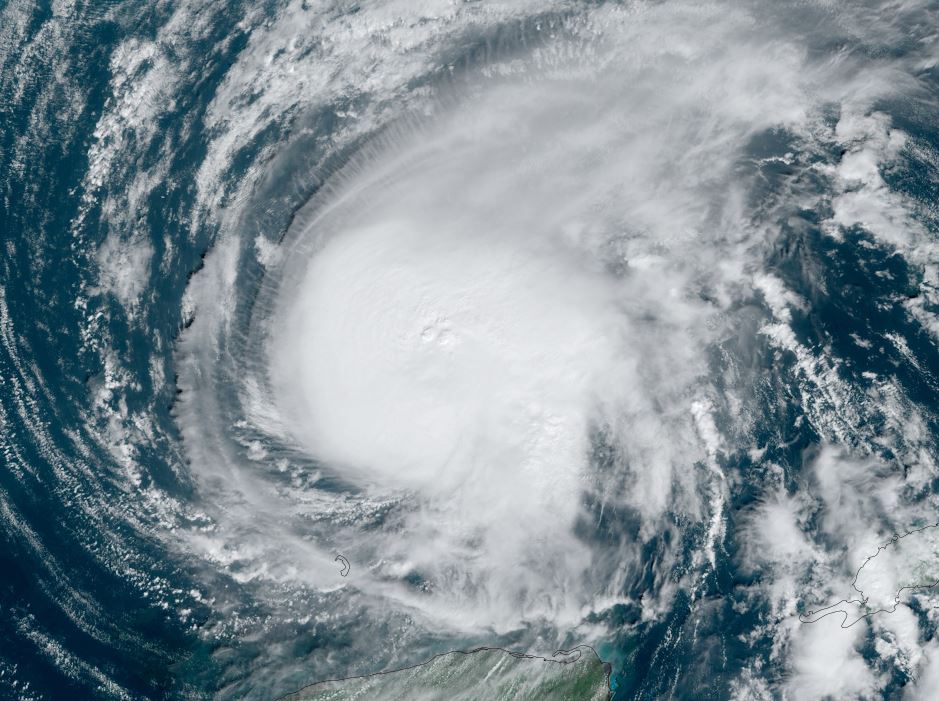
Tropicast: Visible Satellite RAMMB / CIRA Slider Wednesday Early Afternoon
 Tropicast: Visible Satellite RAMMB / CIRA Slider Wednesday Late Afternoon
 Tropical Weather Forecast:
Rafael will move toward the central Gulf over the next few days. It will be facing increasing wind shear and dry air which should weaken the structure into the weekend.
Re: Rafael
Posted: Thu Nov 07, 2024 1:59 pm
by Tropical Inspector
Thursday Afternoon Update
Rafael gaining strength
Rafael is gaining strength as it heads to the central Gulf. Recon shows winds slowly increasing and pressure beginning to drop again.
The Weather Situation
SUMMARY OF 900 AM CST...1500 UTC...INFORMATION
----------------------------------------------
LOCATION...24.5N 85.2W
ABOUT 200 MI...320 KM WNW OF HAVANA CUBA
ABOUT 215 MI...345 KM W OF KEY WEST FLORIDA
MAXIMUM SUSTAINED WINDS...100 MPH...155 KM/H
PRESENT MOVEMENT...WNW OR 295 DEGREES AT 9 MPH...15 KM/H
MINIMUM CENTRAL PRESSURE...971 MB...28.68 INCHES
Tropicast: Visible Satellite RAMMB / CIRA Slider Thursday Morning
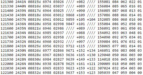
 Tropicast: Recon Thursday Afternoon
 Tropical Weather Forecast:
Rafael will move toward the central Gulf over the next few days. It will be facing increasing wind shear and dry air which should weaken the structure into the weekend.
Re: Rafael
Posted: Fri Nov 08, 2024 1:23 pm
by Tropical Inspector
Friday Afternoon Update
Rafael over the central Gulf
Rafael remains strong, but is slowing in speed over the central Gulf. Satellite shows deep convection to the northwest, but some dry air and weakening is beginning to penetrate on the eastern circulation of the hurricane.
The Weather Situation
SUMMARY OF 900 AM CST...1500 UTC...INFORMATION
----------------------------------------------
LOCATION...24.5N 88.8W
ABOUT 230 MI...365 KM NNE OF PROGRESO MEXICO
ABOUT 535 MI...860 KM E OF MOUTH OF THE RIO GRANDE
MAXIMUM SUSTAINED WINDS...110 MPH...175 KM/H
PRESENT MOVEMENT...W OR 270 DEGREES AT 9 MPH...15 KM/H
MINIMUM CENTRAL PRESSURE...961 MB...28.38 INCHES
Tropicast: Visible Satellite RAMMB / CIRA Slider Friday Morning
 Tropicast: Visible Satellite RAMMB / CIRA Slider Friday Afternoon
 Tropicast: Recon Friday Afternoon
 Tropical Weather Forecast:
Rafael will spin over central Gulf over the next several days, slowly weakening.
Re: Rafael
Posted: Sat Nov 09, 2024 12:52 pm
by Tropical Inspector
Saturday Afternoon Update
Rafael winding down
Rafael is fighting wind shear and dry air. The low center is nearly exposed on the southern side of the central dense overcast. Deep convention remains north and northeast of the low.
The Weather Situation
SUMMARY OF 900 AM CST...1500 UTC...INFORMATION
----------------------------------------------
LOCATION...25.2N 91.5W
ABOUT 290 MI...470 KM NNW OF PROGRESO MEXICO
MAXIMUM SUSTAINED WINDS...50 MPH...85 KM/H
PRESENT MOVEMENT...WNW OR 290 DEGREES AT 6 MPH...9 KM/H
MINIMUM CENTRAL PRESSURE...999 MB...29.50 INCHES
Tropicast: Visible Satellite RAMMB / CIRA Slider Saturday Afternoon
 Tropical Weather Forecast:
Rafael will spin over central Gulf over the next several days, slowly weakening.
Re: Rafael
Posted: Sun Nov 10, 2024 12:34 pm
by Tropical Inspector
Sunday Afternoon Update
Rafael becoming extratropical
Rafael should no longer be officially classified as a tropical storm. NHC makes it a remnant low later today.
The Weather Situation
SUMMARY OF 900 AM CST...1500 UTC...INFORMATION
----------------------------------------------
LOCATION...26.3N 91.9W
ABOUT 370 MI...600 KM NNW OF PROGRESO MEXICO
MAXIMUM SUSTAINED WINDS...40 MPH...65 KM/H
PRESENT MOVEMENT...NNW OR 345 DEGREES AT 3 MPH...6 KM/H
MINIMUM CENTRAL PRESSURE...1003 MB...29.62 INCHES
Tropicast: Visible Satellite RAMMB / CIRA Slider Sunday Afternoon