Page 1 of 1
Joyce
Posted: Fri Sep 27, 2024 8:14 pm
by Tropical Inspector
Friday Evening Update
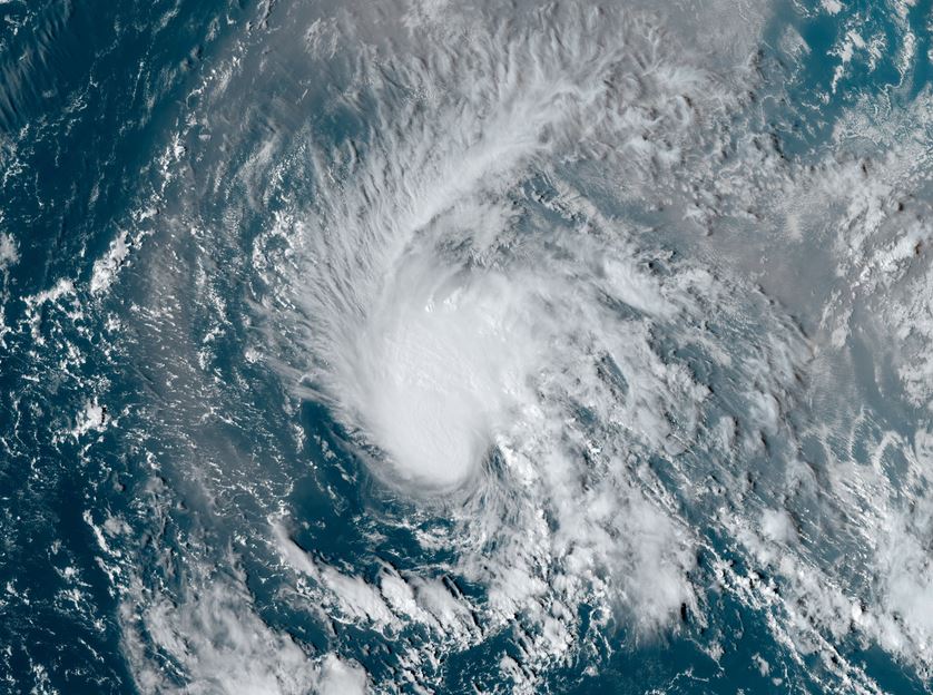
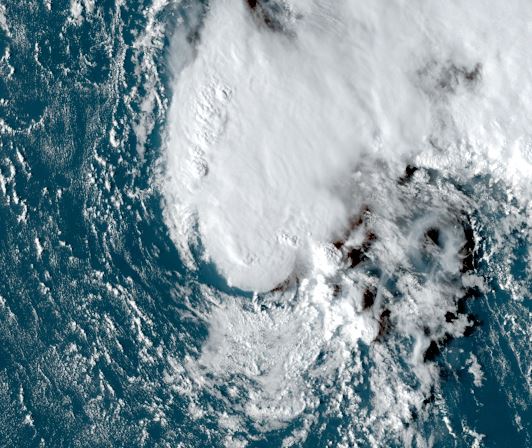
Joyce over open waters
Tropical storm Joyce is over the open waters of the deep tropics. There is a core of deep convection over the circulation. A large area of African dust is seen to the east and northeast of the circulation.
The Weather Situation
SUMMARY OF 500 PM AST...2100 UTC...INFORMATION
----------------------------------------------
LOCATION...18.6N 44.0W
ABOUT 1250 MI...2015 KM E OF THE NORTHERN LEEWARD ISLANDS
MAXIMUM SUSTAINED WINDS...50 MPH...85 KM/H
PRESENT MOVEMENT...NW OR 305 DEGREES AT 13 MPH...20 KM/H
MINIMUM CENTRAL PRESSURE...1001 MB...29.56 INCHES
Tropicast: Visible Satellite RAMMB / CIRA Slider Friday Afternoon
 Tropical Weather Forecast:
Joyce will move generally WNW and not affect land. Upper air winds should increase wind shear and cause convection to be ripped from the circulation.
Re: Joyce
Posted: Sat Sep 28, 2024 6:40 am
by Tropical Inspector
Saturday Morning Update
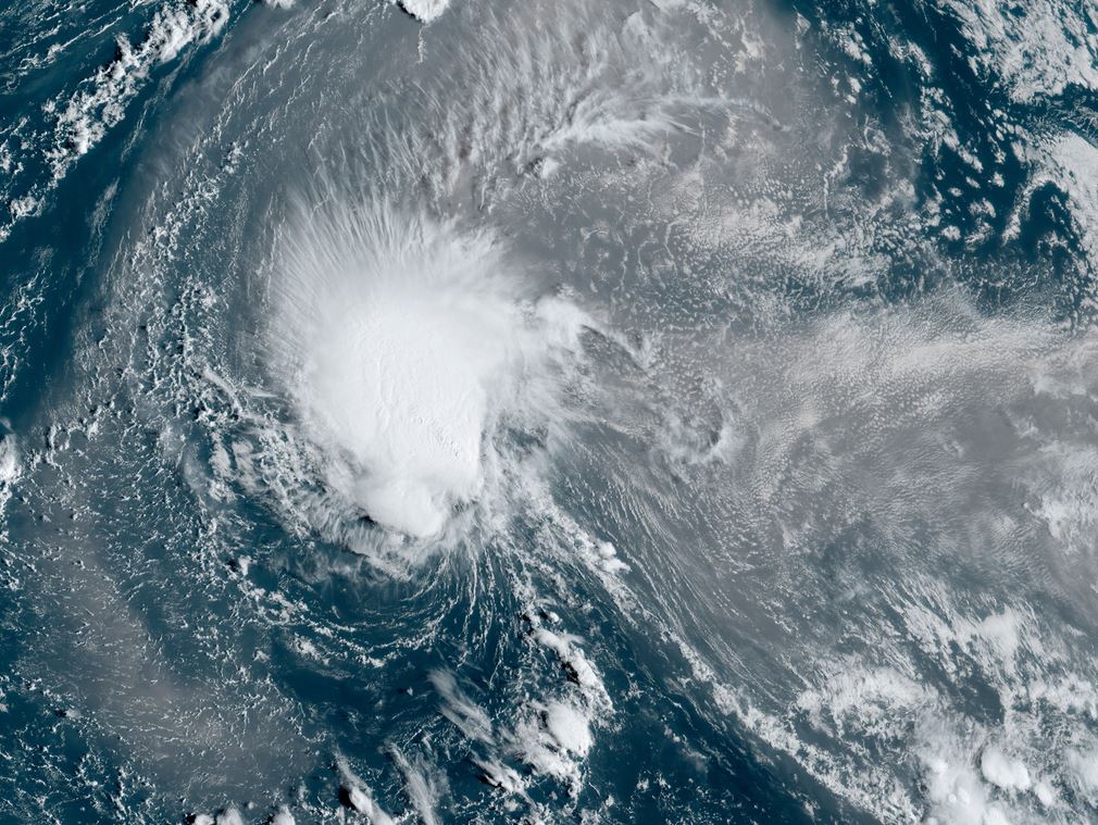
Joyce fighting shear
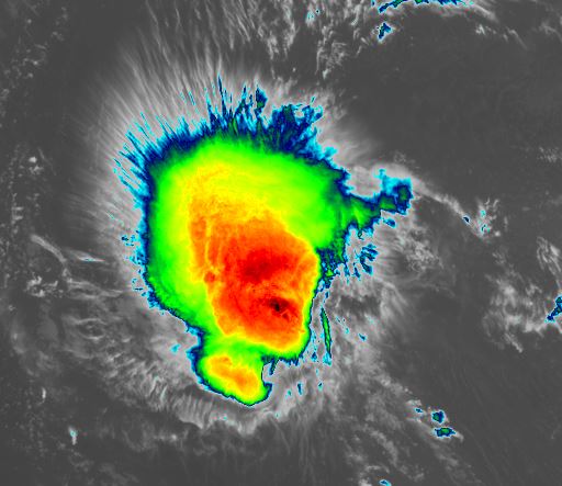
Visible satellite imagery shows that the low level circulation in on the southern edge of the deep convection. Shear is expected to increase over the next few days. African dust is seen as the brownish color on the visible satellite imagery. The IR imagery shows the deepest convection in red / black to the north of the center.
The Weather Situation
SUMMARY OF 500 AM AST...0900 UTC...INFORMATION
----------------------------------------------
LOCATION...19.5N 45.3W
ABOUT 1165 MI...1875 KM E OF THE NORTHERN LEEWARD ISLANDS
MAXIMUM SUSTAINED WINDS...50 MPH...85 KM/H
PRESENT MOVEMENT...NW OR 305 DEGREES AT 10 MPH...17 KM/H
MINIMUM CENTRAL PRESSURE...1004 MB...29.65 INCHES
Tropicast: Visible Satellite RAMMB / CIRA Slider Saturday Morning
 Tropicast: IR Satellite RAMMB / CIRA Slider Saturday Morning
 Tropical Weather Forecast:
Joyce will move generally WNW then briefly turn north and not affect land. Upper air winds should increase wind shear and cause convection to be ripped from the circulation.
Re: Joyce
Posted: Sun Sep 29, 2024 2:30 pm
by Tropical Inspector
Sunday Afternoon Update
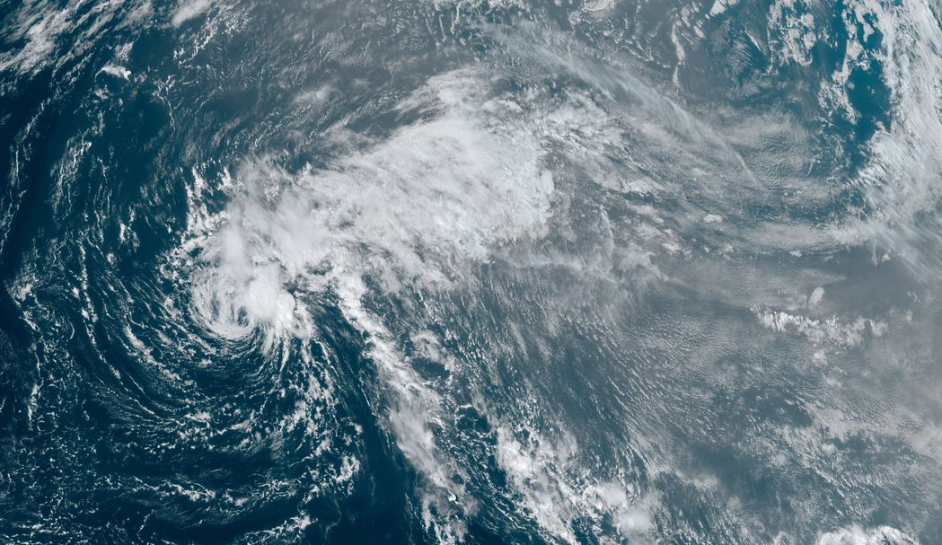
Joyce getting sheared
Visible satellite imagery shows that the only deep convection remaining with Joyce is on the NE quadrant. The low level circulation is completely exposed today. A large area of African dust is apparent to the east of the circulation to the continent of Africa.
The Weather Situation
SUMMARY OF 1100 AM AST...1500 UTC...INFORMATION
-----------------------------------------------
LOCATION...21.6N 48.5W
ABOUT 975 MI...1570 KM ENE OF THE NORTHERN LEEWARD ISLANDS
MAXIMUM SUSTAINED WINDS...45 MPH...75 KM/H
PRESENT MOVEMENT...NW OR 315 DEGREES AT 6 MPH...9 KM/H
MINIMUM CENTRAL PRESSURE...1005 MB...29.68 INCHES
Tropicast: Visible Satellite RAMMB / CIRA Slider Sunday Afternoon
 Tropical Weather Forecast:
Joyce will continue to slowly move north in the open Atlantic waters and become a depression by Monday.
Re: Joyce
Posted: Mon Sep 30, 2024 4:49 pm
by Tropical Inspector
Monday Afternoon Update
Joyce not giving up
Visible satellite imagery shows that the low level circulation has once again moved under convection. This will slow the expected demise as shear has weakened this afternoon.
The Weather Situation
SUMMARY OF 500 PM AST...2100 UTC...INFORMATION
----------------------------------------------
LOCATION...22.7N 48.9W
ABOUT 970 MI...1560 KM ENE OF THE NORTHERN LEEWARD ISLANDS
MAXIMUM SUSTAINED WINDS...35 MPH...55 KM/H
PRESENT MOVEMENT...N OR 360 DEGREES AT 2 MPH...4 KM/H
MINIMUM CENTRAL PRESSURE...1006 MB...29.71 INCHES
Tropicast: Visible Satellite RAMMB / CIRA Slider Monday Afternoon
 Tropical Weather Forecast:
Joyce will continue to slowly move north in the open Atlantic waters and become a depression by Tuesday.