Page 1 of 1
Isaac
Posted: Thu Sep 26, 2024 3:57 pm
by Tropical Inspector
Thursday Late Afternoon Update
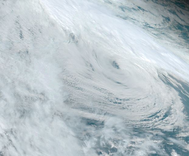
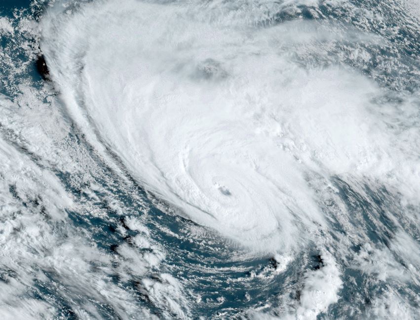
Isaac spinning over open waters
Tropical storm Isaac is a small tropical cyclone. Convection is not very deep over the circulation center as ocean temperatures are not as warm as over the deep tropics to fuel stronger convection.
The Weather Situation
SUMMARY OF 500 PM AST...2100 UTC...INFORMATION
----------------------------------------------
LOCATION...37.5N 50.6W
ABOUT 1285 MI...2070 KM W OF THE AZORES
ABOUT 880 MI...1415 KM ENE OF BERMUDA
MAXIMUM SUSTAINED WINDS...50 MPH...85 KM/H
PRESENT MOVEMENT...E OR 80 DEGREES AT 10 MPH...17 KM/H
MINIMUM CENTRAL PRESSURE...995 MB...29.39 INCHES
Tropicast: Visible Satellite RAMMB / CIRA Slider Thursday Afternoon
 Tropical Weather Forecast:
Isaac is expected to stay in the northern north Atlantic as it moves generally east, north of the Azores during this weekend. It will then become extratropical over the cooler ocean waters.
Re: Isaac
Posted: Fri Sep 27, 2024 5:58 am
by Tropical Inspector
Friday Morning Update
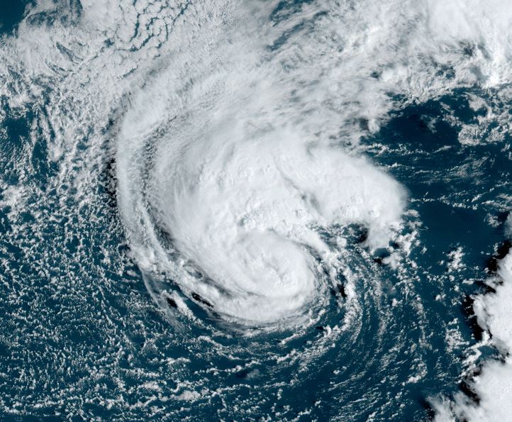
Isaac officially a hurricane
NHC has made Isaac a hurricane. IMO, similar to other high latitude tropical cyclones, I don't believe that this has hurricane strength. IR satellite imagery shows that deep convection is not very strong, which is typical of tropical cyclones over cooler water. In addition, the system should be classified as a subtropical system as it has the appearance of an occlusion. Anyhow, another name goes down in history as a hurricane.
The Weather Situation
SUMMARY OF 500 AM AST...0900 UTC...INFORMATION
----------------------------------------------
LOCATION...37.0N 48.5W
ABOUT 1175 MI...1895 KM W OF THE AZORES
ABOUT 980 MI...1575 KM ENE OF BERMUDA
MAXIMUM SUSTAINED WINDS...75 MPH...120 KM/H
PRESENT MOVEMENT...E OR 90 DEGREES AT 12 MPH...19
Tropicast: Visible Satellite RAMMB / CIRA Slider Friday Morning
 Tropical Weather Forecast:
Isaac is expected to stay in the northern north Atlantic as it moves generally east, north of the Azores during this weekend. It will then become extratropical over the cooler ocean waters.
Re: Isaac
Posted: Fri Sep 27, 2024 8:07 pm
by Tropical Inspector
Friday Evening Update
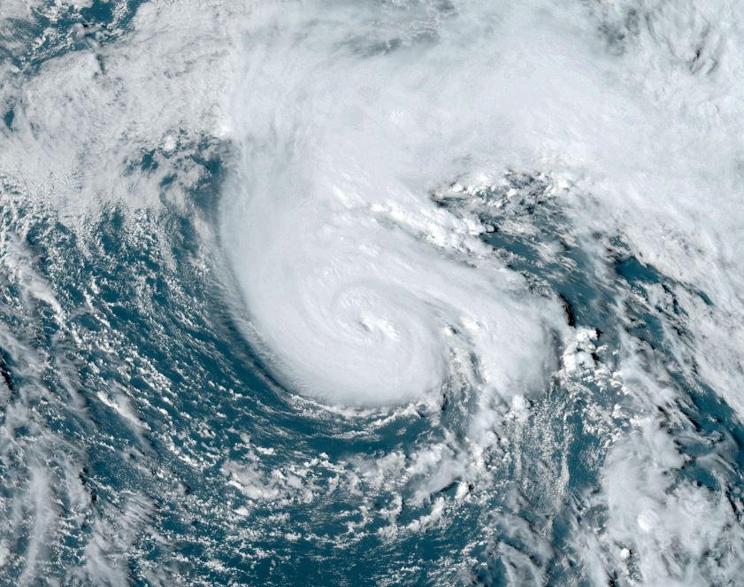
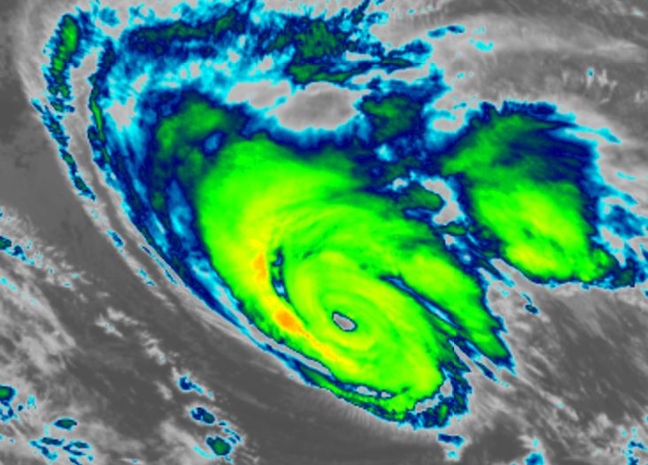
Isaac develops an eye
Late this afternoon Isaac developed a clear eye and convection was a bit deeper. So at this time Isaac may be considered a minimal hurricane. I would still love to see research on the actual strength of these high latitude tropical cyclones with convection that isn't as deep. The IR imagery below shows the image of the convection. Compare with other tropical cyclones in the deep tropics.
The Weather Situation
SUMMARY OF 500 PM AST...2100 UTC...INFORMATION
----------------------------------------------
LOCATION...37.8N 45.3W
ABOUT 995 MI...1600 KM W OF THE AZORES
MAXIMUM SUSTAINED WINDS...85 MPH...140 KM/H
PRESENT MOVEMENT...E OR 80 DEGREES AT 16 MPH...26 KM/H
MINIMUM CENTRAL PRESSURE...976 MB...28.82 INCHES
Tropicast: Visible Satellite RAMMB / CIRA Slider Friday Afternoon
 Tropicast: IR Satellite RAMMB / CIRA Slider Friday Afternoon
 Tropical Weather Forecast:
Isaac is expected to stay in the northern north Atlantic as it moves generally east, north of the Azores during this weekend. It will then become extratropical over the cooler ocean waters.
Re: Isaac
Posted: Sat Sep 28, 2024 6:48 am
by Tropical Inspector
Saturday Morning Update
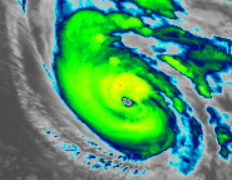
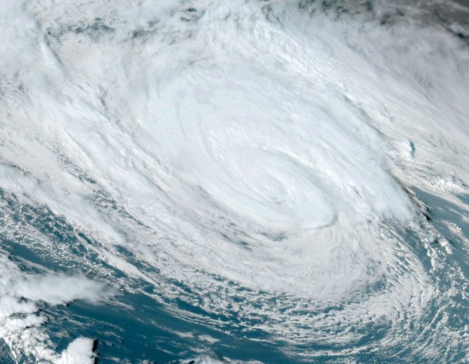
Isaac organizes overnight
Isaac continues to look more organized on the latest satellite imagery. Despite this, IMO I do not think this is a 105 mph hurricane. Convection as seen on the IR satellite is not very deep. For comparison, look at the IR imagery with tropical storm Joyce. I would suggest that top sustained winds are more on the order of 90 mph. Gusts are generally considered at least 20% higher than sustained winds, sometimes considerably higher.
The Weather Situation
SUMMARY OF 900 AM GMT...0900 UTC...INFORMATION
----------------------------------------------
LOCATION...39.3N 41.3W
ABOUT 785 MI...1265 KM W OF THE AZORES
MAXIMUM SUSTAINED WINDS...105 MPH...165 KM/H
PRESENT MOVEMENT...NE OR 55 DEGREES AT 20 MPH...31 KM/H
MINIMUM CENTRAL PRESSURE...968 MB...28.59 INCHES
Tropicast: Visible Satellite RAMMB / CIRA Slider Saturday Morning
 Tropicast: IR Satellite RAMMB / CIRA Slider Saturday Morning
 Tropical Weather Forecast:
Isaac is expected to stay in the northern north Atlantic as it moves generally east, north of the Azores during this weekend. It will then become extratropical over the cooler ocean waters.
Re: Isaac
Posted: Sun Sep 29, 2024 2:37 pm
by Tropical Inspector
Sunday Afternoon Update
Isaac becoming extratropical
Isaac is transitioning into an extra tropical cyclone as it moves over cooler northern North Atlantic waters. The eye has clouded over and cloud tops have warmed, indicating reduced energy for convection. It is still a threat for north Atlantic shipping with rough seas.
The Weather Situation
SUMMARY OF 300 PM GMT...1500 UTC...INFORMATION
----------------------------------------------
LOCATION...43.2N 35.6W
ABOUT 575 MI...925 KM NW OF THE AZORES
MAXIMUM SUSTAINED WINDS...75 MPH...120 KM/H
PRESENT MOVEMENT...NE OR 45 DEGREES AT 12 MPH...19 KM/H
MINIMUM CENTRAL PRESSURE...971 MB...28.68 INCHES
Tropicast: Visible Satellite RAMMB / CIRA Slider Sunday Afternoon
 Tropical Weather Forecast:
Isaac will be an extratropical cyclone soon as it heads NE, to the east of Iceland.
Re: Isaac
Posted: Mon Sep 30, 2024 4:45 pm
by Tropical Inspector
Monday Afternoon Update
Isaac is extratropical
Satellite imagery shows the low level circulation with Isaac in its post tropical state over the northern North Atlantic.
Tropicast: Visible Satellite RAMMB / CIRA Slider Monday Afternoon