Page 1 of 1
Gert
Posted: Sun Aug 20, 2023 12:28 pm
by Tropical Inspector
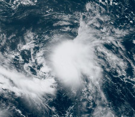
Sunday Afternoon Update
Circulation of TD 6 not impressive
TD six is experience westerly shear and appears to have a weak low level circulation
The Weather Situation
SUMMARY OF 1100 AM AST...1500 UTC...INFORMATION
-----------------------------------------------
LOCATION...16.8N 53.7W
ABOUT 625 MI...1010 KM E OF THE NORTHERN LEEWARD ISLANDS
MAXIMUM SUSTAINED WINDS...35 MPH...55 KM/H
PRESENT MOVEMENT...W OR 280 DEGREES AT 12 MPH...19 KM/H
MINIMUM CENTRAL PRESSURE...1008 MB...29.77 INCHES
Tropicast: Visible satellite
 Tropical Weather Forecast:
TD 6 will likely dissipate soon.
Re: TD 6
Posted: Mon Aug 21, 2023 6:15 am
by Tropical Inspector
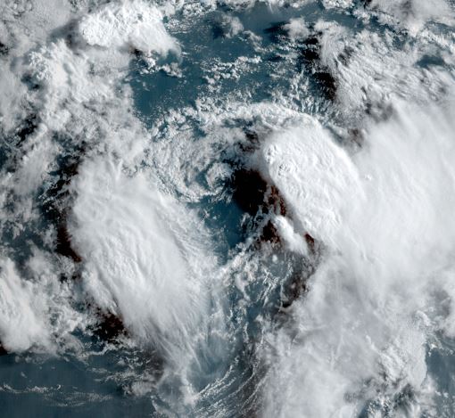
Monday Morning Update
Gert weak
Deep convection exists well east and west of the low center. The low center is exposed and is very weak.
The Weather Situation
SUMMARY OF 500 AM AST...0900 UTC...INFORMATION
----------------------------------------------
LOCATION...16.7N 56.4W
ABOUT 455 MI...730 KM ESE OF THE NORTHERN LEEWARD ISLANDS
MAXIMUM SUSTAINED WINDS...40 MPH...65 KM/H
PRESENT MOVEMENT...W OR 280 DEGREES AT 9 MPH...15 KM/H
MINIMUM CENTRAL PRESSURE...1006 MB...29.71 INCHES
Tropicast: Visible satellite
 Tropical Weather Forecast:
Gert will become extratropical soon
Re: Gert
Posted: Fri Sep 01, 2023 9:41 pm
by Tropical Inspector
Friday Evening Update
Gert rejuvenates
Gert has regained tropical storm strength, but poses no threat to land.
The Weather Situation
SUMMARY OF 500 PM AST...2100 UTC...INFORMATION
----------------------------------------------
LOCATION...27.8N 54.4W
ABOUT 695 MI...1120 KM ESE OF BERMUDA
MAXIMUM SUSTAINED WINDS...40 MPH...65 KM/H
PRESENT MOVEMENT...ESE OR 115 DEGREES AT 5 MPH...7 KM/H
MINIMUM CENTRAL PRESSURE...1006 MB...29.71 INCHES
Tropicast: Visible satellite
Re: Gert
Posted: Sat Sep 02, 2023 8:56 am
by Tropical Inspector
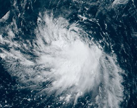
Saturday Morning Update
Gert holding on
Satellite imagery shows that Gert is being sheared by northerly winds aloft. Despite this, deep convection remains organinzed south of the center. IMO, I wouldn't be surprised to see Gert hold on longer than expected.
SUMMARY OF 500 AM AST...0900 UTC...INFORMATION
----------------------------------------------
LOCATION...27.7N 54.3W
ABOUT 705 MI...1130 KM ESE OF BERMUDA
MAXIMUM SUSTAINED WINDS...45 MPH...75 KM/H
PRESENT MOVEMENT...NE OR 40 DEGREES AT 2 MPH...4 KM/H
MINIMUM CENTRAL PRESSURE...1003 MB...29.62 INCHES
Tropicast: Visible satellite
 Tropical Weather Forecast:
Gert is expected to become extratropical within about 24 hours.
NHC Advisory
https://www.nhc.noaa.gov/text/refresh/M ... 838.shtml?
NHC Track
https://www.nhc.noaa.gov/refresh/graphi ... e#contents