Page 1 of 1
Potential Tropical Cyclone 10
Posted: Sun Aug 27, 2017 1:49 pm
by Tropical Inspector
A low pressure system is developing east of the Georgia coast and a tropical / subtropical cyclone is likely to develop soon. It will move up the southeastern coast then east of the mid atlantic.
Re: TD 10
Posted: Sun Aug 27, 2017 5:35 pm
by Tropical Inspector
Sunday Evening UpdatePotential tropical cyclone 10 formsThe Weather SituationConvection is growing east of Georgia with several low level swirls. There is a chance for this to become a minimal tropical storm before it moves near the coast of South and North Carolina Monday into Monday night. It will gain much more strength as it moves away from the mid atlantic and taps energy from the jet stream.
Current Tropical WeatherAs of 5:00 PM EDT PTC 10 was centered at 31.2 N / 80.0 W or 110 miles south of Charleston, South Carolina. It was stationary. Top sustained winds are estimated at 35 mph. Pressure was estimated at 1007 MB.
Tropical Weather Forecast:Potential tropical cyclone 10 will likely strengthen and move over eastern North Carolina Monday night. It will then move out to sea and merge with a front and become extratropical.
Tropicast: Visible Satellite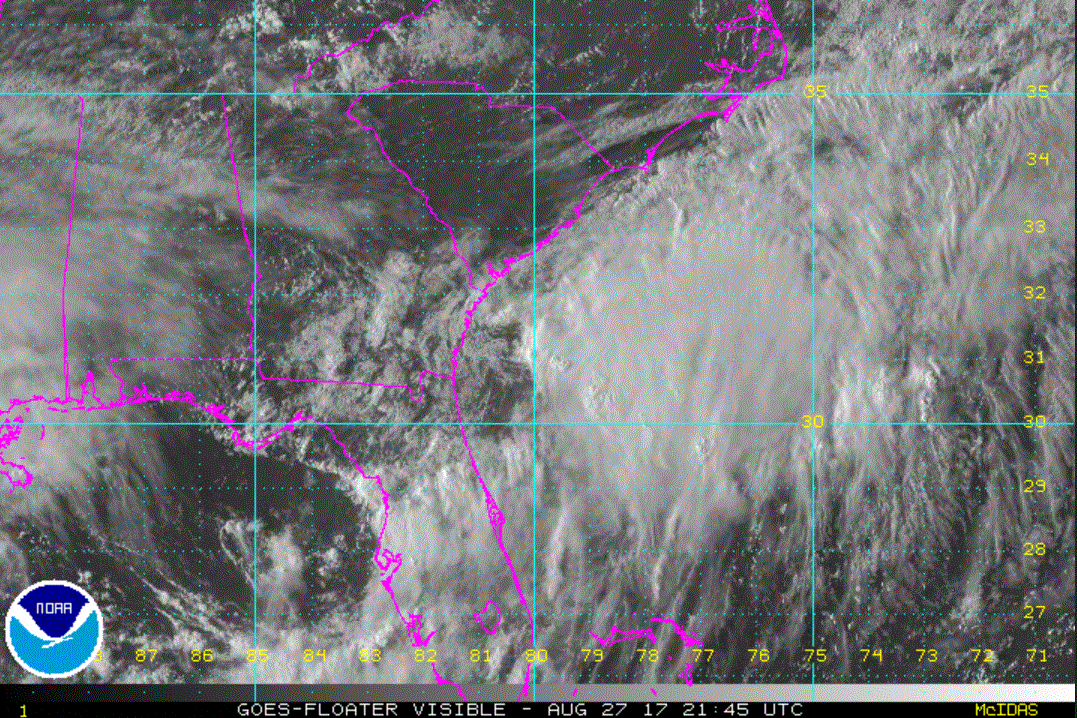
Re: TD 10
Posted: Mon Aug 28, 2017 3:10 pm
by Tropical Inspector
Monday Afternoon UpdatePotential tropical cyclone 10The Weather SituationAir force reconnaissance did not find a well defined low level center earlier today. Since then, satellite imagery shows a more defined low center. It is possible that NHC will classify this as the next tropical cyclone sometime this evening. The main hazard will be heavy rainfall on the coast of Eastern North Carolina.
Current Tropical WeatherAs of 5:00 PM EDT PTC 10 was centered at 32.2 N / 80.1 W or 40 miles south of Charleston, South Carolina. It was moving NE at 12 mph. Top sustained winds are estimated at 40 mph. Pressure was estimated at 1006 MB.
Tropical Weather Forecast:Potential tropical cyclone 10 will likely strengthen and move along the coast of South Carolina tonight then across eastern North Carolina Wednesday. It will rapidly move NE away from the mid atlantic after that and merge with a front and become extratropical.
Tropicast: Visible Satellite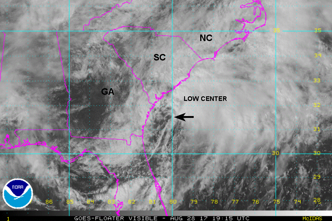
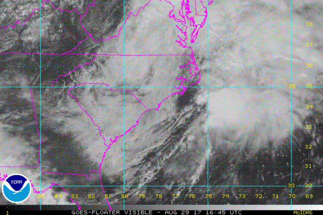
Re: TD 10
Posted: Tue Aug 29, 2017 12:39 pm
by Tropical Inspector
Tuesday Afternoon UpdatePotential tropical cyclone 10The Weather SituationWesterly winds aloft have kept deep convection from wrapping around the low center. This has effectively stopped PTC 10 from becoming a tropical or subtropical cyclone.
Current Tropical WeatherAs of 2:00 PM EDT PTC 10 was centered at 35.3 N / 75.8 W or 20 miles WNW of Cape Hatteras North Carolina. It was moving NE at 20 mph. Top sustained winds are estimated at 40 mph. Pressure was estimated at 1006 MB.
Tropical Weather Forecast:Potential tropical cyclone 10 will become extratropical during the next 12-24 hours. It will accelerate NE in the northern north atlantic and become a gale center.
Tropicast: Visible Satellite