Tropical Depression 2 E

Tropicial cyclone archives of the 2010 eastern and central Pacific hurricane season
Post Reply
User avatar
Tropical Inspector
Site Admin
Site Admin
Posts: 3629
Joined: Tue Feb 20, 2007 2:28 pm
Antispam: no
Location: Under a palm tree
Contact:

Tropical Depression 2 E

Post by Tropical Inspector »

Wednesday Afternoon Update

Tropical depression 2E forms


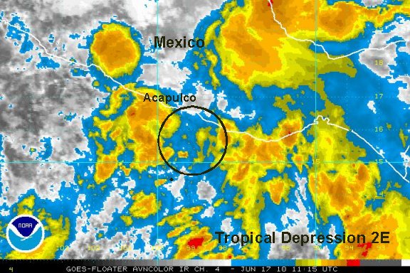
As of 1:00 pm edt / 10:00 am pdt tropical depression 2E was centered at 14.8°N / 95.6°W or about 100 miles ssw of Salina Cruz, Mexico. The monsoon trough has been active for a couple of days now. A spin has gradually organized into tropical depression 2E. It is forecast to move parallel to the coast for the next couple of days. Some strengthening is forecast and this system should be a tropical storm in the next 24-36 hours.

:!: Interests in southern and Mexico should follow this system.

Tropicast: Pacific Floater I.R. Satellite
Image
Rich Johnson
Twitter: https://twitter.com/richjohnsonwx
Certified Broadcast Meteorologist - Hurricane Expert
User avatar
Tropical Inspector
Site Admin
Site Admin
Posts: 3629
Joined: Tue Feb 20, 2007 2:28 pm
Antispam: no
Location: Under a palm tree
Contact:

Re: Tropical Depression 2 classified

Post by Tropical Inspector »

Wednesday Evening Update

Tropical depression 2E changes little


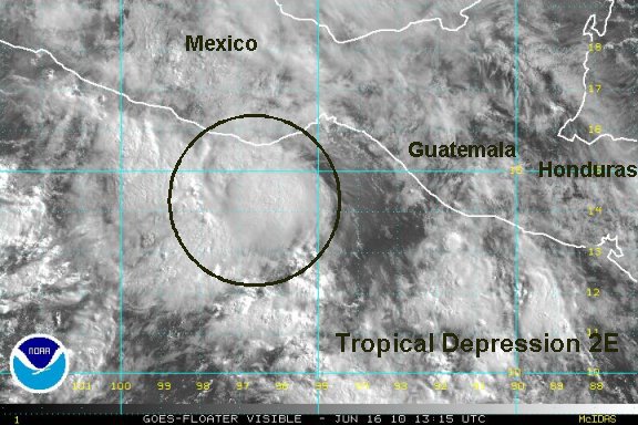
As of 8:00 pm edt / 5:00 pm pdt tropical depression 2E was centered at 15.0°N / 96.3°W or about 50 miles sse of Puerto Angel, Mexico. Movement is wnw at about 3 mph. Top sustatined wind are estimated at 30 mph (NHC 30 mph).

The overall appearance of 2E is little different from this afternoon. Heavy showers and storms have built up on the coast of Mexico which wll produce locally 1-3" or rainfall. Forecasts call for the low to stay offshore and parallel the coast the next couple of days before moving into the open Pacific.

:!: Interests in southern and western Mexico should follow this system.

Tropicast: Pacific Floater I.R. Satellite
Image
Rich Johnson
Twitter: https://twitter.com/richjohnsonwx
Certified Broadcast Meteorologist - Hurricane Expert
User avatar
Tropical Inspector
Site Admin
Site Admin
Posts: 3629
Joined: Tue Feb 20, 2007 2:28 pm
Antispam: no
Location: Under a palm tree
Contact:

Re: Tropical Depression 2 classified

Post by Tropical Inspector »

Thursday Morning Update

Tropical depression 2E weakening

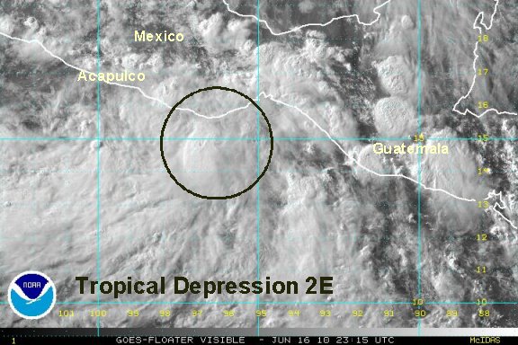
Tropical depression 2E has struggled overnight and is hard to even locate a center of circulation.

As of 8:00 am edt / 5:00 am pdt tropical depression 2E was centered at 15.6°N / 99.0°W or about 30 miles sse of Puento Maldonado. (Our postion estimate is more to the west). Movement is wnw at about 10 mph. Top sustatined wind are estimated at 25 mph (NHC 30 mph).

Tropical depression 2E is struggling with its proximity to land and with the effects of another unoffical tropical depression that has developed to the west. If 2E still is able to survive both of these effects, it still may have a chance to become a tropical storm as it moves farther offshore.


:!: Interests in southern and western Mexico should follow this system.

Tropicast: Pacific Floater I.R. Satellite
Image
Rich Johnson
Twitter: https://twitter.com/richjohnsonwx
Certified Broadcast Meteorologist - Hurricane Expert
User avatar
Tropical Inspector
Site Admin
Site Admin
Posts: 3629
Joined: Tue Feb 20, 2007 2:28 pm
Antispam: no
Location: Under a palm tree
Contact:

Re: Tropical Depression 2 E

Post by Tropical Inspector »

The hurricane has dropped advisories on 2E.
Rich Johnson
Twitter: https://twitter.com/richjohnsonwx
Certified Broadcast Meteorologist - Hurricane Expert
Post Reply

Return to “2010 Eastern / Central Pacific Huricane Season Archives”

Who is online

Users browsing this forum: No registered users and 0 guests