Tropical depression 9-e

Tropicial cyclone archives of the 2009 eastern and central Pacific hurricane season
Post Reply
User avatar
Tropical Inspector
Site Admin
Site Admin
Posts: 3697
Joined: Tue Feb 20, 2007 2:28 pm
Antispam: no
Location: Under a palm tree
Contact:

Tropical depression 9-e

Post by Tropical Inspector »

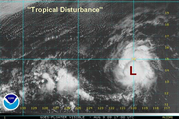
Sunday Afternoon Update

Tropical depression forming - not a threat to Mexico

A spin is now apparent under a burst of deep convection centered near 14 N / 120 W or about 890 miles southwest of Cabo San Lucas. Earlier this was displayed as a sharp tropical wave on the Quickscat satellite. We now think that there is enough evidence to classify this as a tropical depression. It is moving west at about 8 mph.

This system is NOT a threat to Mexico.

Tropicast: Pacific Floater Visible Satellite
Image
Rich Johnson
Twitter: https://twitter.com/richjohnsonwx
Certified Broadcast Meteorologist - Hurricane Expert
User avatar
Tropical Inspector
Site Admin
Site Admin
Posts: 3697
Joined: Tue Feb 20, 2007 2:28 pm
Antispam: no
Location: Under a palm tree
Contact:

Re: New tropical depression forming in eastern Pacific

Post by Tropical Inspector »

Sunday Night Update

Tropical depression 9-E classified

After a very impressive burst, tropical depression 9-e lost most of its convection. Over the past couple of hours a new round of convection has started.

It is centered near 13.9° N / 120.6° or about 925 miles southwest of Cabo San Lucas, Mexico. It is moving west at about 7 mph.

This system is NOT a threat to Mexico.

Tropicast: Pacific Floater Visible Satellite
Image
Rich Johnson
Twitter: https://twitter.com/richjohnsonwx
Certified Broadcast Meteorologist - Hurricane Expert
User avatar
Tropical Inspector
Site Admin
Site Admin
Posts: 3697
Joined: Tue Feb 20, 2007 2:28 pm
Antispam: no
Location: Under a palm tree
Contact:

Re: Tropical depression 9-e

Post by Tropical Inspector »

Monday Morning Update

Tropical depression 9-E changes little

The depression has held onto deep convection, but still is fighting wind shear. The overall appearance has not changed over the last several hours. If the shear weakens a touch 9-e will become Guillermo.

It is centered near 14.9° N / 122.1° or about 970 miles southwest of Cabo San Lucas, Mexico. Top sustained winds are still estimated at 35 mph. It is moving west at about 8 mph.

This system is NOT a threat to Mexico.

Tropicast: Pacific Floater Visible Satellite
Image
Rich Johnson
Twitter: https://twitter.com/richjohnsonwx
Certified Broadcast Meteorologist - Hurricane Expert
User avatar
Tropical Inspector
Site Admin
Site Admin
Posts: 3697
Joined: Tue Feb 20, 2007 2:28 pm
Antispam: no
Location: Under a palm tree
Contact:

Re: Tropical depression 9-e

Post by Tropical Inspector »

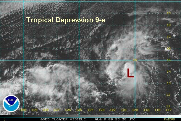
Monday Afternoon Update

More of the same....

Fairly impressive convection continues on the southeast side of the circulation of the depression. With the help of visible satellite imagery, the center now is clearly visible and is very tiny. It's still not quite at tropical storm strength yet.

As of 1:30 pm edt / 10:30 am pdt the depression is centered near 14.9° N / 123.9° or about 1060 miles west southwest of Cabo San Lucas, Mexico. Top sustained winds are still estimated at 35 mph. It is moving west at about 9 mph.

This system is NOT a threat to Mexico.

Tropicast: Pacific Floater Visible Satellite
Image
Rich Johnson
Twitter: https://twitter.com/richjohnsonwx
Certified Broadcast Meteorologist - Hurricane Expert
User avatar
Tropical Inspector
Site Admin
Site Admin
Posts: 3697
Joined: Tue Feb 20, 2007 2:28 pm
Antispam: no
Location: Under a palm tree
Contact:

Re: Tropical depression 9-e

Post by Tropical Inspector »

Tuesday Morning Update

Still disorganized

Tropical depression 9-e is in no hurry to develop. It is still fighting westerly wind shear. Deep convection is hanging on, on the eastern side of the circulation. We still believe that the shear will weaken enough for this to become a tropical storm in the next day or two.

As of 7:30 am edt / 4:30 am pdt the depression is centered near 15.1° N / 126.5° or about 1195 miles west southwest of Cabo San Lucas, Mexico. Top sustained winds are still estimated at 35 mph. It is moving west at about 13 mph.

This system is NOT a threat to Mexico.

Tropicast: Pacific Floater I.R. Satellite
Image
Rich Johnson
Twitter: https://twitter.com/richjohnsonwx
Certified Broadcast Meteorologist - Hurricane Expert
User avatar
Tropical Inspector
Site Admin
Site Admin
Posts: 3697
Joined: Tue Feb 20, 2007 2:28 pm
Antispam: no
Location: Under a palm tree
Contact:

Re: Tropical depression 9-e

Post by Tropical Inspector »

Tuesday Afternoon Update

(update was miskakenly deleted)
Rich Johnson
Twitter: https://twitter.com/richjohnsonwx
Certified Broadcast Meteorologist - Hurricane Expert
User avatar
Tropical Inspector
Site Admin
Site Admin
Posts: 3697
Joined: Tue Feb 20, 2007 2:28 pm
Antispam: no
Location: Under a palm tree
Contact:

Re: Tropical depression 9-e

Post by Tropical Inspector »

Wednesday Morning Update

9-e still trying to become a tropical storm

Tropical depression 9-e continues to hold a little below tropical storm strength. Just when convection starts to build, it soon collapses and weakens. Over the past few hours a new round of scattered convection is building near the center. We'll see if it can actually hold on this time.

As of 8:00 am edt / 5:00 am pdt / 2:00 am hst the depression is centered near 14.7° N / 131.7° or about 1525 miles west southwest of Cabo San Lucas, Mexico / 1580 miles east southeast of Hilo, Hawaii. Top sustained winds are still estimated at 35 mph. It is moving west at about 13 mph.

This system is NOT a threat to Mexico.

Tropicast: Pacific Floater I.R. Satellite
Image
Rich Johnson
Twitter: https://twitter.com/richjohnsonwx
Certified Broadcast Meteorologist - Hurricane Expert
User avatar
Tropical Inspector
Site Admin
Site Admin
Posts: 3697
Joined: Tue Feb 20, 2007 2:28 pm
Antispam: no
Location: Under a palm tree
Contact:

Re: Tropical depression 9-e

Post by Tropical Inspector »

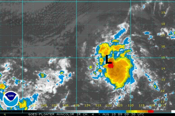
Wednesday Afternoon Update

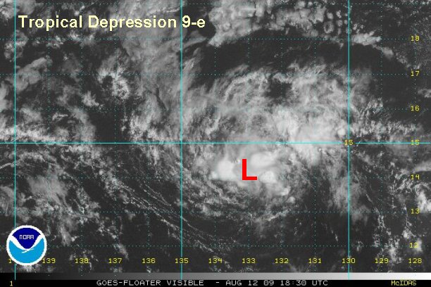
9-e changes little

There has been overall little change today. The tropical depression appears to be moving south of due west now. It also still looks like the mid level and low level circulation are still not co-located. This indicates that it is still not quite organized yet. We expect a more west southwest course to take over as a high builds north. 9-e is still expected to become a tropical storm.

As of 3:00 pm edt / 12:00 pm pdt / 9:00 am hst the depression is centered near 14.1° N / 132.9° or about 1610 miles west southwest of Cabo San Lucas, Mexico / 1515 miles east southeast of Hilo, Hawaii. Top sustained winds are still estimated at 35 mph. It is moving west southwest at about 14 mph.

This system is NOT a threat to Mexico.

Tropicast: Pacific Floater Visible Satellite
Image
Rich Johnson
Twitter: https://twitter.com/richjohnsonwx
Certified Broadcast Meteorologist - Hurricane Expert
User avatar
Tropical Inspector
Site Admin
Site Admin
Posts: 3697
Joined: Tue Feb 20, 2007 2:28 pm
Antispam: no
Location: Under a palm tree
Contact:

Re: Tropical depression 9-e

Post by Tropical Inspector »

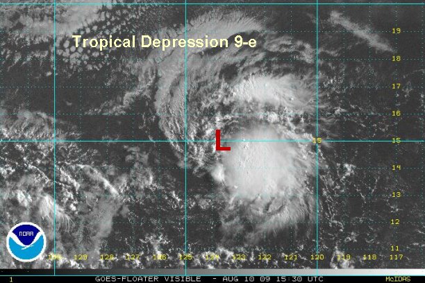
Wednesday Night Update

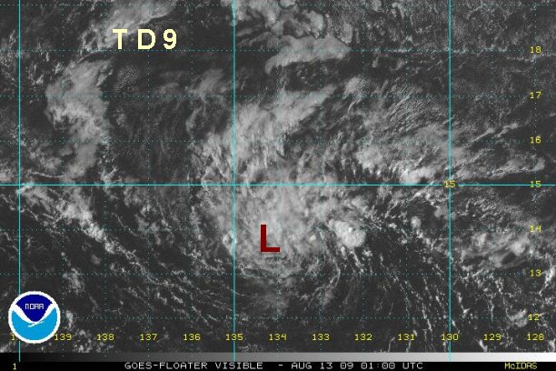
9-e very weak

The weakening trend has continued and we're beginning to wonder if td 9 will ever develop. The low is now broad and diffuse with little convection.

As of 10:00 pm edt / 7:00 pm pdt / 4:00 pm hst the depression is centered near 13.8° N / 134.4° or about 1715 miles west southwest of Cabo San Lucas, Mexico / 1425 miles east southeast of Hilo, Hawaii. Top sustained winds are estimated at 30 mph. It is moving west southwest at about 14 mph.

This system is NOT a threat to Mexico.

Tropicast: Pacific Floater Visible Satellite
Image
Rich Johnson
Twitter: https://twitter.com/richjohnsonwx
Certified Broadcast Meteorologist - Hurricane Expert
User avatar
Tropical Inspector
Site Admin
Site Admin
Posts: 3697
Joined: Tue Feb 20, 2007 2:28 pm
Antispam: no
Location: Under a palm tree
Contact:

Re: Tropical depression 9-e

Post by Tropical Inspector »

9-e has weakened. This will be the last update unless regeneration occurs.
Rich Johnson
Twitter: https://twitter.com/richjohnsonwx
Certified Broadcast Meteorologist - Hurricane Expert
User avatar
Tropical Inspector
Site Admin
Site Admin
Posts: 3697
Joined: Tue Feb 20, 2007 2:28 pm
Antispam: no
Location: Under a palm tree
Contact:

Re: Tropical depression 9-e

Post by Tropical Inspector »

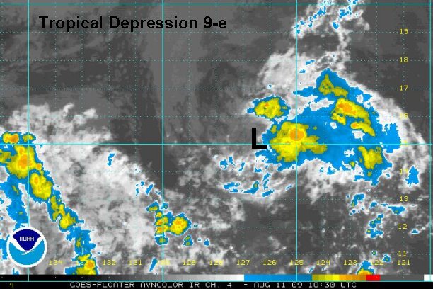
Thursday Afternoon Update

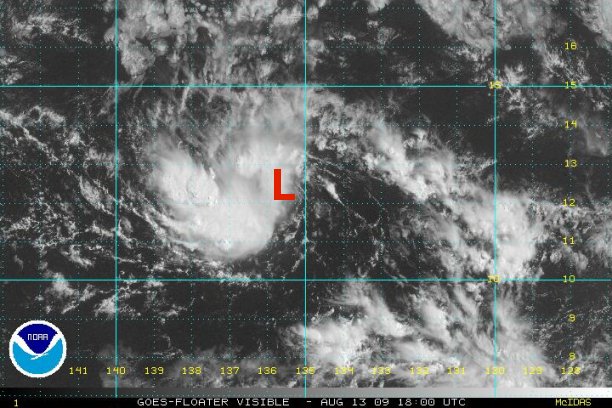
Tropical depression 9-e coming back to life

Just after esssentially writing tropical depression 9-e off, it is now making a comeback. Deep convection is building on the west side of the circulation. The east side remains weak and top sustained winds are estimated near 10 mph.

As of 3:00 pm edt / 12:00 pm pdt / 9:00 am hst the depression is centered near 12° N / 136 W° or about 1800 miles west southwest of Cabo San Lucas, Mexico / 1435 miles east southeast of Hilo, Hawaii. Top sustained winds are estimated at 30 mph. It is moving west southwest at about 14 mph.

This system is NOT a threat to Mexico.

Tropicast: Pacific Floater Visible Satellite
Image
Rich Johnson
Twitter: https://twitter.com/richjohnsonwx
Certified Broadcast Meteorologist - Hurricane Expert
User avatar
Tropical Inspector
Site Admin
Site Admin
Posts: 3697
Joined: Tue Feb 20, 2007 2:28 pm
Antispam: no
Location: Under a palm tree
Contact:

Re: Tropical depression 9-e

Post by Tropical Inspector »

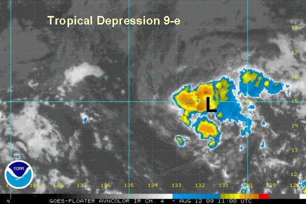
Friday Evening Update

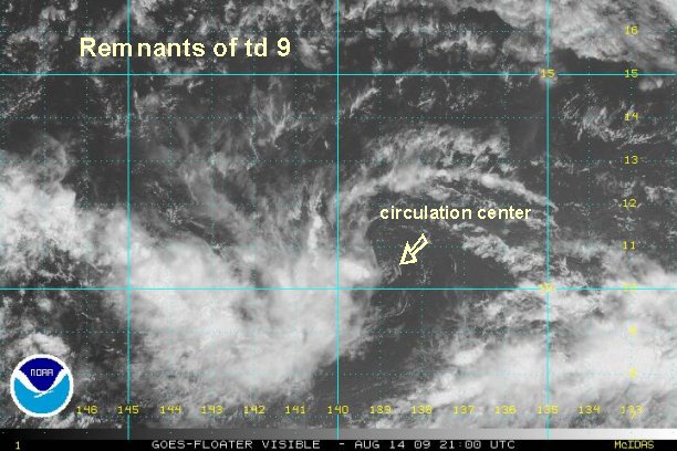
Remnants of Tropical depression 9-e dead

Visible satellite imagery show that the circulation center is now very diffuse. This will be the last update.


Tropicast: Pacific Floater Visible Satellite
Image
Rich Johnson
Twitter: https://twitter.com/richjohnsonwx
Certified Broadcast Meteorologist - Hurricane Expert
Post Reply

Return to “2009 Eastern / Central Pacific Hurricane Season Archives”

Who is online

Users browsing this forum: No registered users and 0 guests