Erin

User avatar
Tropical Inspector
Site Admin
Site Admin
Posts: 3743
Joined: Tue Feb 20, 2007 2:28 pm
Antispam: no
Location: Under a palm tree
Contact:

Re: Erin

Post by Tropical Inspector »

Thursday Morning Update

Erin turning away
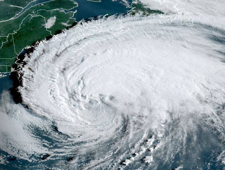
Erin is now starting to move away from the US east coast as it pulls away from North Carolina. High surf and strong rip tides remain a concern. Winds and rainfall have not been an issue. IR satellite imagery show that there is still deep convection near the core and also away from the center. A Hurricane Hunter aircraft confirms little change in strength over night, except for a little weakening. Winds at 10,000 ft were measured at 100 knots or 115 mph. A correction factor for surface estimate is 90%, so winds to about 100 mph is an estimate.

The Weather Situation
SUMMARY OF 500 AM EDT...0900 UTC...INFORMATION
----------------------------------------------
LOCATION...34.2N 72.1W
ABOUT 205 MI...330 KM ESE OF CAPE HATTERAS NORTH CAROLINA
ABOUT 440 MI...710 KM WNW OF BERMUDA
MAXIMUM SUSTAINED WINDS...105 MPH...165 KM/H
PRESENT MOVEMENT...NNE OR 20 DEGREES AT 17 MPH...28 KM/H
MINIMUM CENTRAL PRESSURE...945 MB...27.91 INCHES

Update:
SUMMARY OF 800 AM EDT...1200 UTC...INFORMATION
----------------------------------------------
LOCATION...34.8N 71.8W
ABOUT 210 MI...340 KM E OF CAPE HATTERAS NORTH CAROLINA
ABOUT 440 MI...710 KM WNW OF BERMUDA
MAXIMUM SUSTAINED WINDS...105 MPH...165 KM/H
PRESENT MOVEMENT...NNE OR 25 DEGREES AT 17 MPH...28 KM/H
MINIMUM CENTRAL PRESSURE...945 MB...27.91 INCHES

Tropicast: RAMMB/CIRA slider IR Satellite
Image

Tropicast: Radar GR Level 3 5:18 am edt
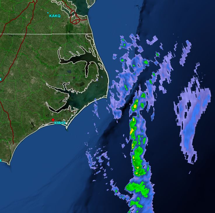
Image

Tropicast: Wundermap Windstream 5:20 am edt
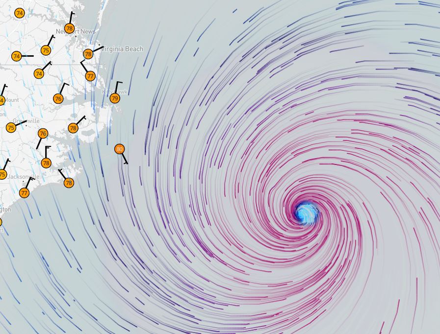
Image

Tropicast: Hurricane Hunter Report
Strongest gust - 100 knots.
Image

Tropical Weather Forecast:
Erin is moving away from the Mid-Atlantic coast. It will continue NE well west, then north of Bermuda as it heads into the northern North Atlantic Ocean. Very significant high surf and strong rip tides on the eastern US coast will continue today, and slowly diminish into Friday and Saturday.
Rich Johnson
LinkedIn: https://www.linkedin.com/in/richjohnsonmeteorologist/
AMS Certified Broadcast Meteorologist (CBM) - Hurricane Expert
User avatar
Tropical Inspector
Site Admin
Site Admin
Posts: 3743
Joined: Tue Feb 20, 2007 2:28 pm
Antispam: no
Location: Under a palm tree
Contact:

Re: Erin

Post by Tropical Inspector »

Thursday Evening Update

Erin well offshore
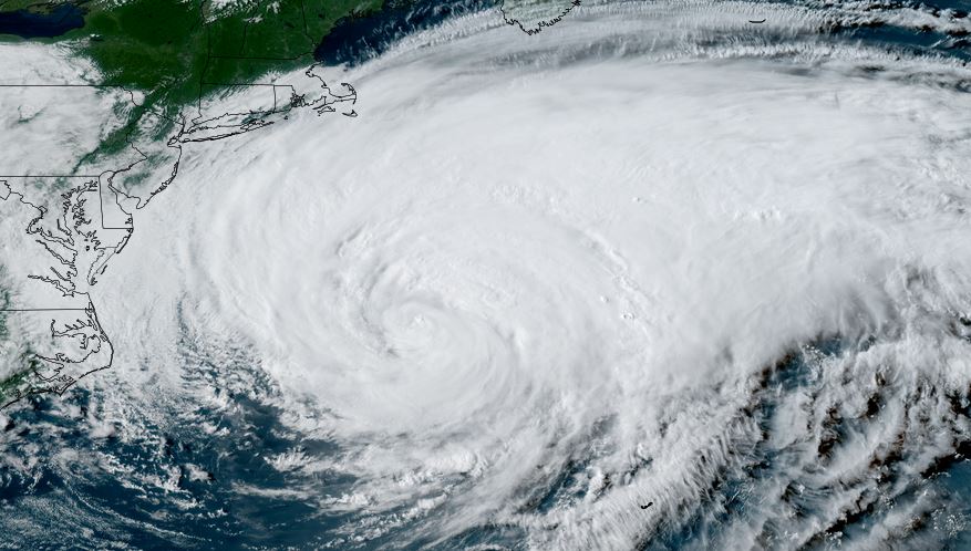
Erin is well east of the Mid-Atlantic coast, but caution still should be used on Mid-Atlantic and Northeastern beaches as surf will continue to be higher than normal. A small area of deep convection is near the center of circulation and it will continue to spread as Erin is beginning to become extratropical and should make that transition in the next 24-36 hours.

The Weather Situation
SUMMARY OF 500 PM AST...2100 UTC...INFORMATION
----------------------------------------------
LOCATION...36.4N 69.1W
ABOUT 370 MI...590 KM ENE OF CAPE HATTERAS NORTH CAROLINA
ABOUT 375 MI...600 KM NW OF BERMUDA
MAXIMUM SUSTAINED WINDS...100 MPH...155 KM/H
PRESENT MOVEMENT...NE OR 50 DEGREES AT 20 MPH...31 KM/H
MINIMUM CENTRAL PRESSURE...952 MB...28.12 INCHES

Tropicast: RAMMB/CIRA slider GOES 19 Visible Satellite
Image

Tropical Weather Forecast:
Erin is well northwest of Bermuda and will continue into the northern North Atlantic Ocean. Significant high surf and strong rip tides on the eastern US coast will continue today, and slowly diminish into Friday and Saturday. Similarly, high surf will also slowly diminish on the coast of Bermuda.
Rich Johnson
LinkedIn: https://www.linkedin.com/in/richjohnsonmeteorologist/
AMS Certified Broadcast Meteorologist (CBM) - Hurricane Expert
User avatar
Tropical Inspector
Site Admin
Site Admin
Posts: 3743
Joined: Tue Feb 20, 2007 2:28 pm
Antispam: no
Location: Under a palm tree
Contact:

Re: Erin

Post by Tropical Inspector »

Friday Afternoon Update

Erin extratropical
Deep convection is removed from the core of the low and upper air energy is fueling the winds.

The Weather Situation
SUMMARY OF 1100 AM AST...1500 UTC...INFORMATION
-----------------------------------------------
LOCATION...38.8N 63.1W
ABOUT 460 MI...740 KM NNE OF BERMUDA
ABOUT 400 MI...645 KM S OF HALIFAX NOVA SCOTIA
MAXIMUM SUSTAINED WINDS...90 MPH...150 KM/H
PRESENT MOVEMENT...ENE OR 65 DEGREES AT 28 MPH...44 KM/H
MINIMUM CENTRAL PRESSURE...956 MB...28.23 INCHES

Tropicast: RAMMB/CIRA slider GOES 19 Visible Satellite Friday Morning
Image

Tropical Weather Forecast:
Erin is essentially extratropical now. Significant high surf and strong rip tides on the eastern US coast will continue today will slowly diminish the next few days.

NHC Advisory
https://www.nhc.noaa.gov/text/refresh/M ... 438.shtml?

NHC Track
https://www.nhc.noaa.gov/refresh/graphi ... e#contents
Rich Johnson
LinkedIn: https://www.linkedin.com/in/richjohnsonmeteorologist/
AMS Certified Broadcast Meteorologist (CBM) - Hurricane Expert
Post Reply

Return to “2025 Atlantic Hurricane Updates”

Who is online

Users browsing this forum: No registered users and 3 guests