Page 2 of 2
Re: Beryl
Posted: Fri Jul 05, 2024 9:26 pm
by Tropical Inspector
Friday Night Update
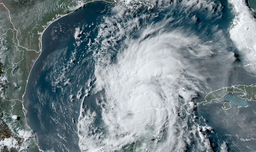
Beryl in the Gulf
Beryl crossed the Yucatan peninsula today and made its way into the southern Gulf. It appears to be farther north than models anticipated. Most of the deep convection has dissipated, but restrengthening is expected as the low level circulation remains intact.
The Weather Situation
SUMMARY OF 700 PM CDT...0000 UTC...INFORMATION
----------------------------------------------
LOCATION...21.3N 89.7W
ABOUT 0 MI...0 KM E OF PROGRESO MEXICO
ABOUT 580 MI...935 KM ESE OF BROWNSVILLE TEXAS
MAXIMUM SUSTAINED WINDS...65 MPH...100 KM/H
PRESENT MOVEMENT...WNW OR 295 DEGREES AT 15 MPH...24 KM/H
MINIMUM CENTRAL PRESSURE...994 MB...29.35 INCHES
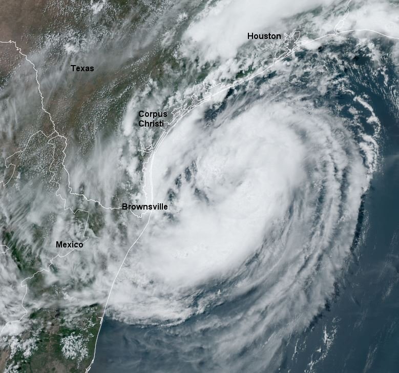
Tropicast: Visible Satellite
 Tropical Weather Forecast:
Beryl track has shifted northward. It is now expected to cross the southern Gulf and move northwest toward the central Texas coast. Interests on all of the western Gulf coast should follow the progress of Beryl as the model may shift further. At this time landfall is expected Sunday night or now possibly Monday if it moves farther northward, likely regaining hurricane strength.
Re: Beryl
Posted: Sat Jul 06, 2024 6:41 am
by Tropical Inspector
Saturday Morning Update
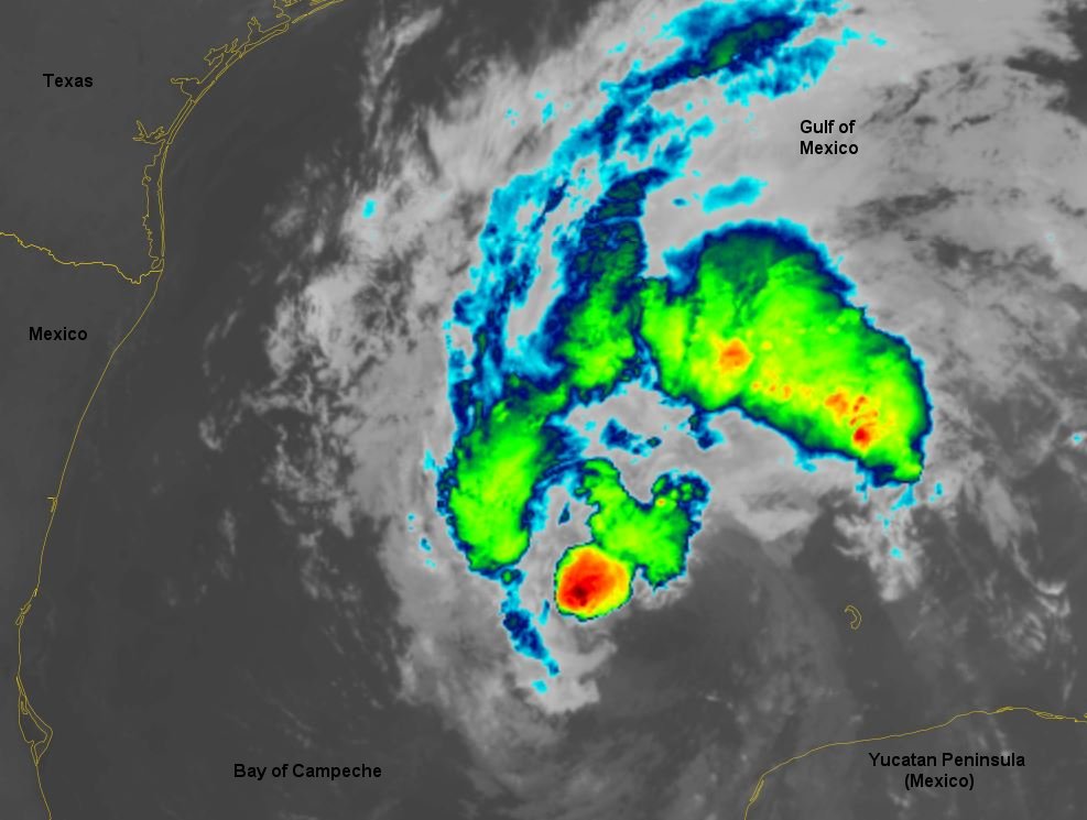
Beryl showing slight strengthening
IR satellite imagery shows the first small regeneration of deep convection near the low level circulation.
The Weather Situation
SUMMARY OF 700 AM CDT...1200 UTC...INFORMATION
----------------------------------------------
LOCATION...22.7N 91.9W
ABOUT 495 MI...795 KM SE OF CORPUS CHRISTI TEXAS
MAXIMUM SUSTAINED WINDS...60 MPH...95 KM/H
PRESENT MOVEMENT...WNW OR 300 DEGREES AT 12 MPH...19 KM/H
MINIMUM CENTRAL PRESSURE...999 MB...29.50 INCHES
Tropicast: IR Satellite
 Tropical Weather Forecast:
Beryl is expected to restrengthen into a hurricane and make landfall on the central Texas coast Monday. Damaging winds, heavy rainfall, and storm surge are expected near its path. Also, rip tides will increase as wave action increases along Gulf beaches where swell from Beryl is experienced. Isolated tornadoes will be seen on outer rain bands once Beryl strengthens and the bands move inland.
Re: Beryl
Posted: Sat Jul 06, 2024 4:03 pm
by Tropical Inspector
Saturday Evening Update
Beryl unchanged in strength today
Visible satellite imagery shows that Beryl is fighting wind shear. Deep convection exists generally west of the circulation center and little to the east. A Hurricane Hunter is investigating and IMO the 60 mph sustained surface estimate is very generous. SFMR readings have been significantly lower.
The Weather Situation
SUMMARY OF 400 PM CDT...2100 UTC...INFORMATION
----------------------------------------------
LOCATION...23.9N 93.0W
ABOUT 385 MI...615 KM SE OF CORPUS CHRISTI TEXAS
MAXIMUM SUSTAINED WINDS...60 MPH...95 KM/H
PRESENT MOVEMENT...NW OR 310 DEGREES AT 13 MPH...20 KM/H
MINIMUM CENTRAL PRESSURE...997 MB...29.44 INCHES
Tropicast: Visible Satellite
 Tropical Weather Forecast:
Beryl is expected to restrengthen into a hurricane and make landfall on the central Texas coast Monday. Damaging winds, heavy rainfall, and storm surge are expected near its path. Also, rip tides will increase as wave action increases along Gulf beaches where swell from Beryl is experienced. Isolated tornadoes will be seen on outer rain bands once Beryl strengthens and the bands move inland.
Re: Beryl
Posted: Sun Jul 07, 2024 6:09 am
by Tropical Inspector
Sunday Morning Update
Beryl approaching the Texas coast
IR satellite imagery show that convection has slightly increased since last evening, but still lacks organization. IMO 60 mph is still a generous wind estimate for surface sustained winds.

All Beryl preparations should be finished this morning on the the Texas coast.
The Weather Situation
SUMMARY OF 400 AM CDT...0900 UTC...INFORMATION
----------------------------------------------
LOCATION...25.3N 94.6W
ABOUT 245 MI...390 KM SSE OF MATAGORDA TEXAS
ABOUT 245 MI...395 KM SE OF CORPUS CHRISTI TEXAS
MAXIMUM SUSTAINED WINDS...60 MPH...95 KM/H
PRESENT MOVEMENT...NW OR 320 DEGREES AT 12 MPH...19 KM/H
MINIMUM CENTRAL PRESSURE...995 MB...29.39 INCHES
Tropicast: IR Satellite
 Tropical Weather Forecast:
Beryl is expected to restrengthen into a minimal hurricane and make landfall on the central Texas coast early Monday a little after midnight. Damaging winds, heavy rainfall, and storm surge are expected near its path. Also, rip tides will increase as wave action increases along Gulf beaches where swell from Beryl is experienced. Isolated tornadoes will be seen on outer rain bands once Beryl strengthens and the bands move inland.
Re: Beryl
Posted: Sun Jul 07, 2024 3:40 pm
by Tropical Inspector
Sunday Late Afternoon Update
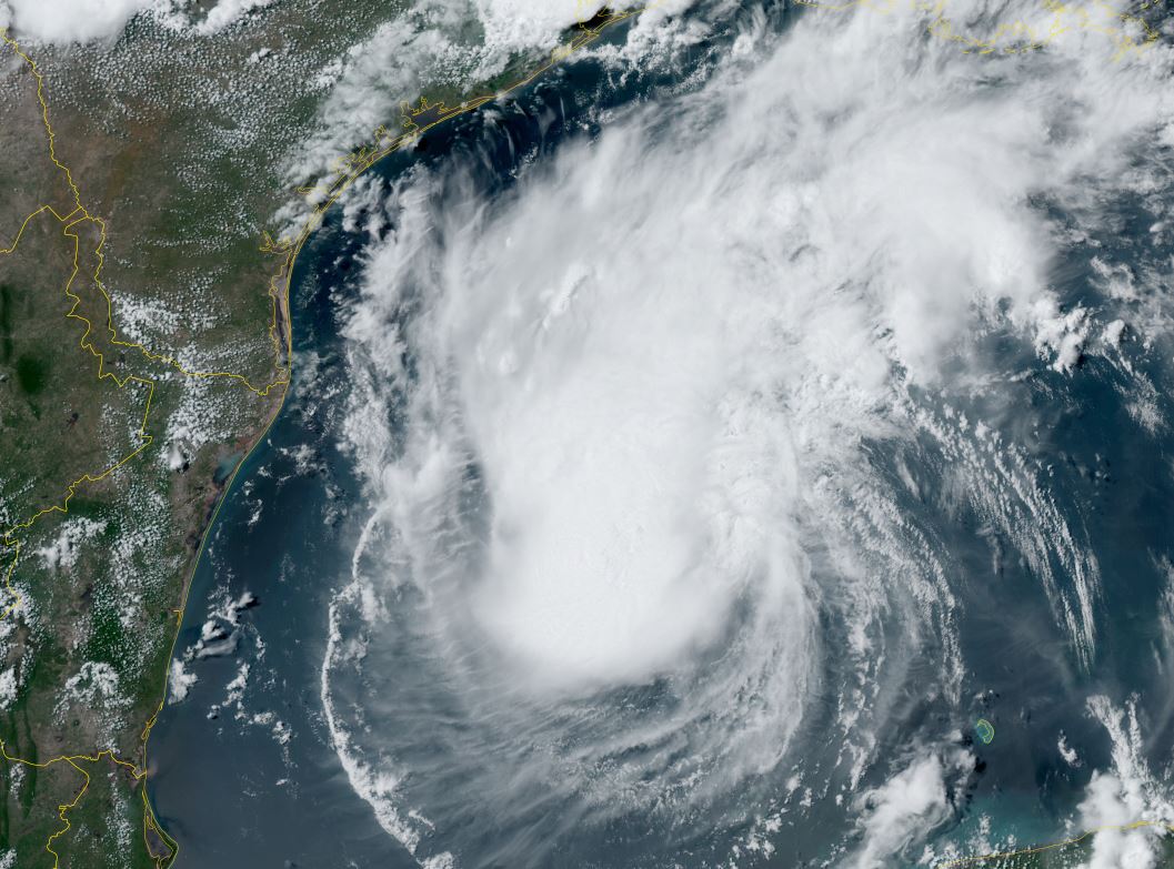
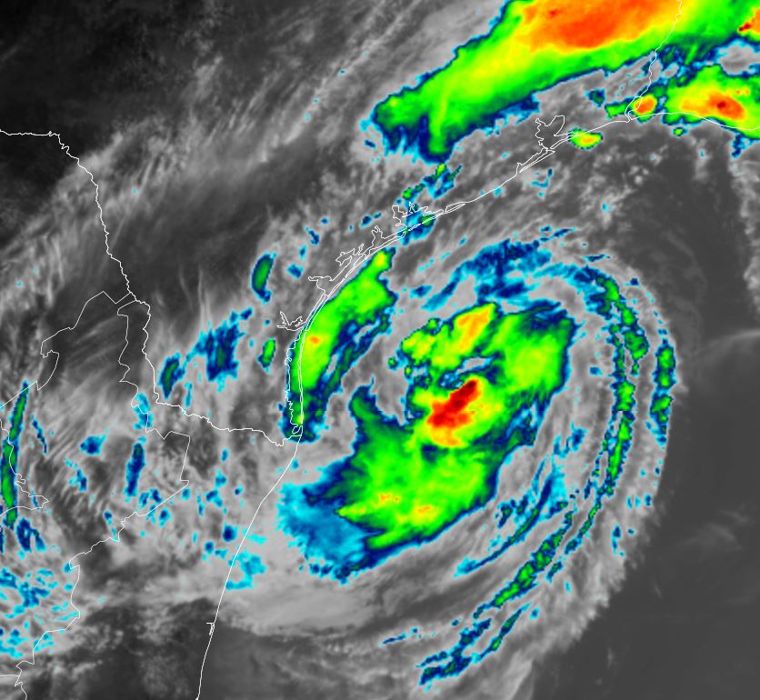
Beryl starting to organize
Satellite imagery shows that Beryl is beginning to organize this afternoon. NHC's forecast of Beryl becoming a category 1 hurricane before landfall is still on target. Hurricane Hunter reports show that the winds are slowly increasing and pressure is dropping. Indicating the strengthening phase.
The Weather Situation
SUMMARY OF 400 PM CDT...2100 UTC...INFORMATION
----------------------------------------------
LOCATION...26.8N 95.5W
ABOUT 130 MI...205 KM SSE OF MATAGORDA TEXAS
ABOUT 135 MI...220 KM ESE OF CORPUS CHRISTI TEXAS
MAXIMUM SUSTAINED WINDS...65 MPH...100 KM/H
PRESENT MOVEMENT...NNW OR 335 DEGREES AT 12 MPH...19 KM/H
MINIMUM CENTRAL PRESSURE...988 MB...29.18 INCHES
Tropicast: Visible Satellite
 Tropicast: IR Satellite
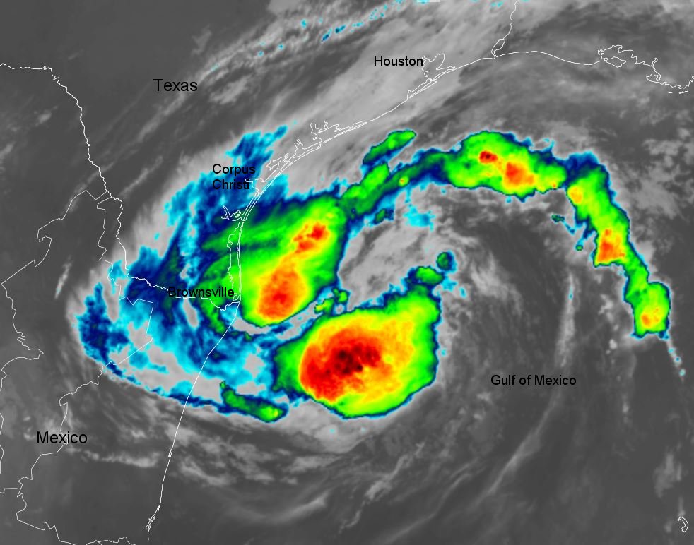
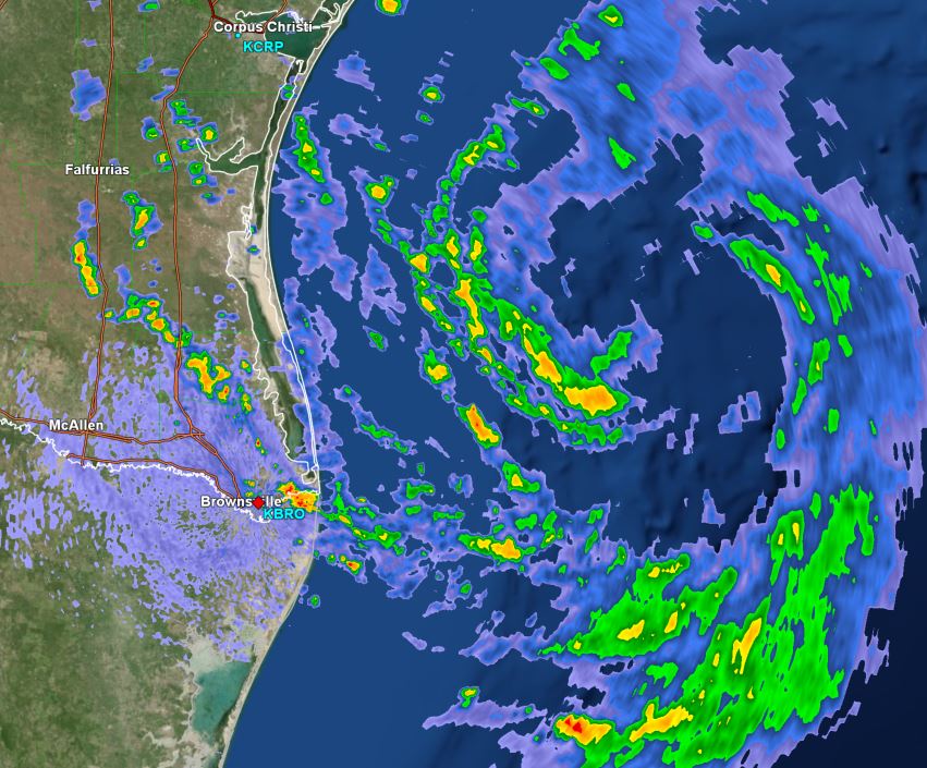
 Tropicast: Brownsville, TX Radar 3:40 pm cdt
 Tropical Weather Forecast:
Beryl will likely be a category 1 hurricane at landfall on Monday a little after midnight. Damaging winds, heavy rainfall, and storm surge are expected near its path. Also, rip tides will increase as wave action increases along Gulf beaches where swell from Beryl is experienced. Isolated tornadoes will be seen on outer rain bands as they move inland.
Re: Beryl
Posted: Sun Jul 07, 2024 8:31 pm
by Tropical Inspector
Sunday Night Update
Beryl almost a hurricane
Reports from a recent Hurricane Hunter show that pressure continues to drop. Radar also shows an eyewall forming. It is likely that Beryl will become a hurricane just before landfall several hours from now.
The Weather Situation
SUMMARY OF 700 PM CDT...0000 UTC...INFORMATION
----------------------------------------------
LOCATION...27.1N 95.6W
ABOUT 105 MI...170 KM SSE OF MATAGORDA TEXAS
ABOUT 120 MI...195 KM ESE OF CORPUS CHRISTI TEXAS
MAXIMUM SUSTAINED WINDS...70 MPH...110 KM/H
PRESENT MOVEMENT...NNW OR 340 DEGREES AT 12 MPH...19 KM/H
MINIMUM CENTRAL PRESSURE...987 MB...29.15 INCHES
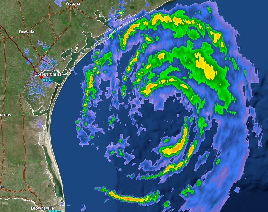
Tropicast: Brownsville, TX Radar 8:25 pm cdt
 Tropical Weather Forecast:
Beryl will likely be a category 1 hurricane at landfall on Monday a little after midnight. Damaging winds, heavy rainfall, and storm surge are expected near its path. Also, rip tides will increase as wave action increases along Gulf beaches where swell from Beryl is experienced. Isolated tornadoes will be seen on outer rain bands as they move inland.
Re: Beryl
Posted: Mon Jul 08, 2024 5:02 am
by Tropical Inspector
Monday Morning Update
Beryl makes landfall
The Weather Situation
SUMMARY OF 400 AM CDT...0900 UTC...INFORMATION
----------------------------------------------
LOCATION...28.6N 96.0W
ABOUT 0 MI...0 KM N OF MATAGORDA TEXAS
ABOUT 85 MI...135 KM SSW OF HOUSTON TEXAS
MAXIMUM SUSTAINED WINDS...80 MPH...130 KM/H
PRESENT MOVEMENT...N OR 355 DEGREES AT 12 MPH...19 KM/H
MINIMUM CENTRAL PRESSURE...979 MB...28.91 INCHES
Tropicast: Houston, TX Radar 4:55 am cdt (GR level3)
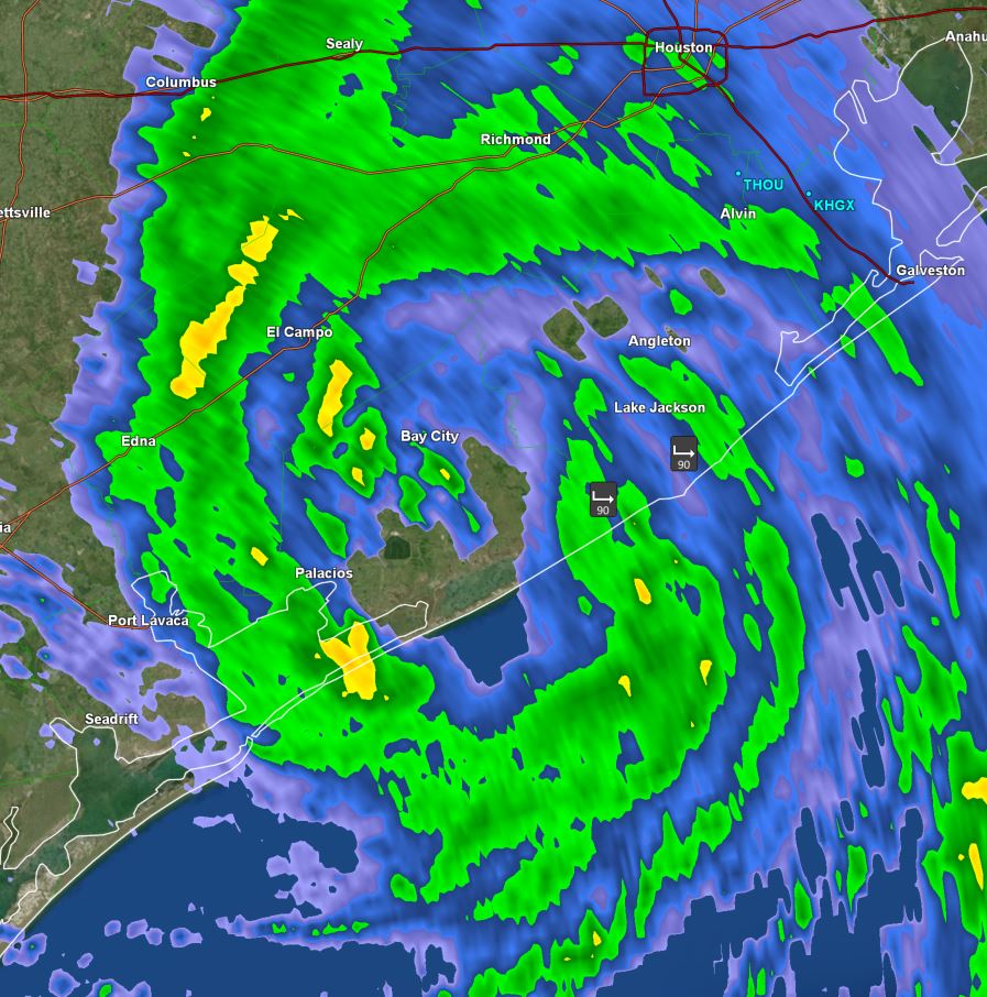 Tropical Weather Forecast:
Beryl has made landfall and winds will drop over the next several hours. Heavy rainfall which may produce flash flooding can be expected well inland.