Page 2 of 2
Re: Jose
Posted: Sat Sep 16, 2017 8:16 am
by Tropical Inspector
Saturday Morning UpdateRip current danger on eastern US coastsThe Weather SituationLook for surf / rip current risk to increase on the Mid Atlantic, Northeast U.S. and Bermuda SW / W coasts to increase as Jose move north the next few days. Surf will subside on the north shore of Hispaniola / Puerto Rico and Bahamas.
A tropical storm watch may be issued by NHC late today for parts of the Mid Atlantic.
Current Tropical WeatherAs of 5:00 AM AST Jose was centered at 27.9 N / 71.8 W or 550 miles SE of Cape Hatteras / 515 miles SW of Bermuda. It was moving NW at 9mph. Top sustained winds are estimated at 80 mph. Pressure was estimated at 983 MB.
Tropical Weather Forecast:Jose is now moving NW. It should turn more to the north soon. Interests in the the Mid Atlantic and Northeast US as well as eastern Canada should monitor the progress of Jose.
Tropicast: Visible Satellite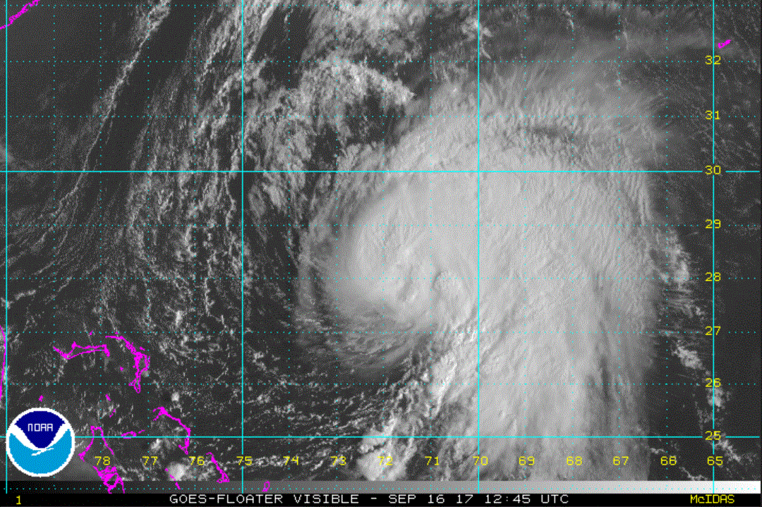
Re: Jose
Posted: Sun Sep 17, 2017 7:25 am
by Tropical Inspector
Sunday Morning UpdateRip current / high surf on eastern US coastsThe Weather SituationShear has weakened some and convection has become more widespread. Look for surf / rip current risk to increase on the Mid Atlantic, Northeast U.S. and Bermuda SW / W coasts to increase as Jose move north the next few days.
Current Tropical WeatherAs of 5:00 AM AST Jose was centered at 30.0 N / 71.7 W or 420 miles SSE of Cape Hatteras / 435 miles WSW of Bermuda. It was moving north at 8 mph. Top sustained winds are estimated at 80 mph. Pressure was estimated at 973 MB.
Tropical Weather Forecast:Jose is moving north. Interests in the the Mid Atlantic and Northeast US as well as eastern Canada should monitor the progress of Jose. The main effects will be high surf / strong rip currents. Some rain bands may approach southern New England Monday / Tuesday.
Tropicast: Visible Satellite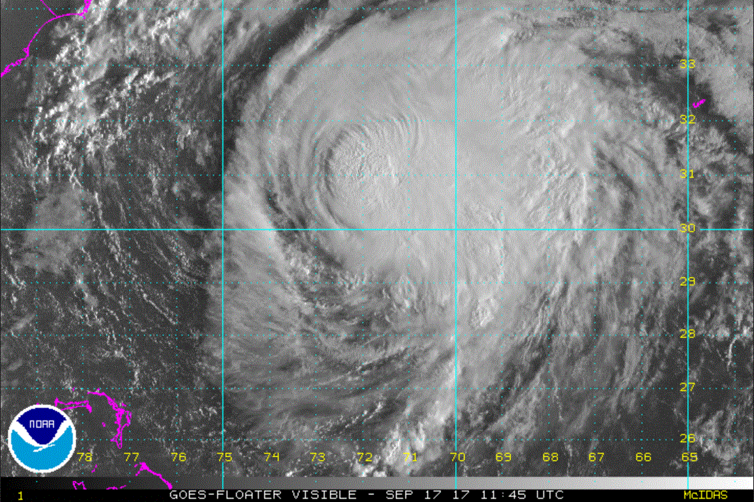
Re: Jose
Posted: Mon Sep 18, 2017 7:52 am
by Tropical Inspector
Monday Morning UpdateJose remains east of US coastThe Weather SituationShear continues to affect Jose. The main effects will be high surf and strong rip currents on the Mid Atlantic coasts with some wind gusts to tropical storm force. The best chance for significant rainfall will be on the SE Massachusetts coast.
Current Tropical WeatherAs of 8:00 AM EDT Jose was centered at 33.5 N / 71.2 W or 270 miles ESE of Cape Hatteras / 380 miles west of Bermuda. It was moving north at 9 mph. Top sustained winds are estimated at 85 mph. Pressure was estimated at 976 MB.
Tropical Weather Forecast:Jose is moving north. It will likely stall SE of Cape Cod later this week and loop to the south. It will lose strength and become extratropical as it stays over colder water.
Interests in the the Mid Atlantic and Northeast US should monitor the progress of Jose. The main effects will be high surf / strong rip currents. Some rain bands may approach southern New England and the Mid Atlantic coast the next several days.
Tropicast: Visible Satellite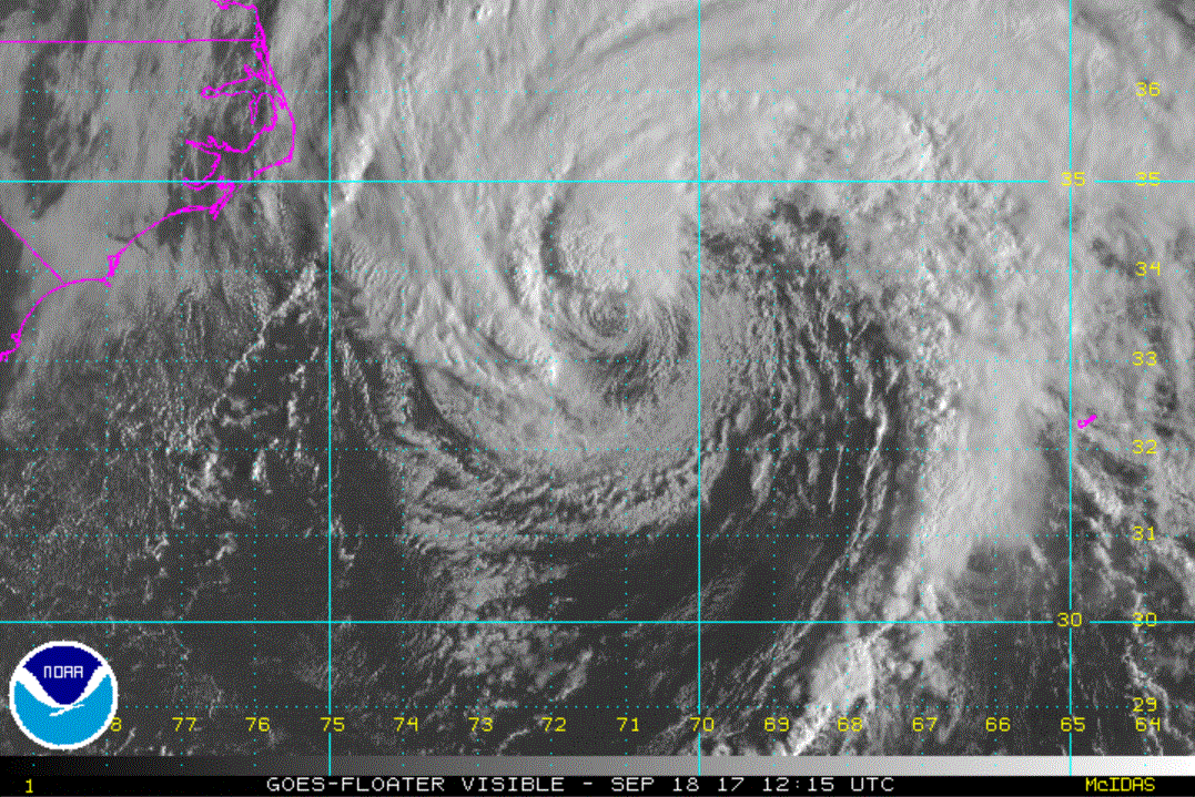
Re: Jose
Posted: Tue Sep 19, 2017 7:42 am
by Tropical Inspector
Tuesday Morning UpdateJose brings rough surf to Northeast USThe Weather SituationJose is losing tropical characteristics slowly. It is still a tropical system, but should soon drop below hurricane strength as it moves over cooler water. Rough surf and a few rain bands will be the main concern.
Current Tropical WeatherAs of 8:00 AM EDT Jose was centered at 36.3 N / 71.6 W or 235 miles ENE of Cape Hatteras / 355 miles SSW of Nantucket, MA. It was moving north at 9 mph. Top sustained winds are estimated at 75 mph. Pressure was estimated at 973 MB.
Tropical Weather Forecast:Jose is moving north. It will likely stall SE of Cape Cod later this week and loop to the south. It will lose strength and become extratropical as it stays over colder water.
Interests in the the Mid Atlantic and Northeast US should monitor the progress of Jose. The main effects will be high surf / strong rip currents. Some rain bands may approach southern New England and the Mid Atlantic coast the next several days.
Tropicast: Visible Satellite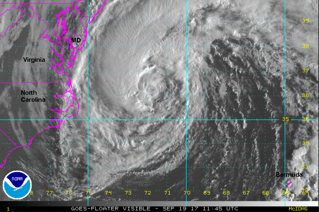
Re: Jose
Posted: Wed Sep 20, 2017 9:34 am
by Tropical Inspector
Wedesday Morning UpdateJose slowing, weakeningThe Weather SituationJose is slowly weakening over cooler water.
Current Tropical WeatherAs of 8:00 AM EDT Jose was centered at 38.8 N / 70.2 W or 165 miles south of Nantucket, MA. It was moving NE at 8 mph. Top sustained winds are estimated at 65 mph. Pressure was estimated at 976 MB.
Tropical Weather Forecast:Jose will loop to the south and weaken soon. It will lose strength and become extratropical as it stays over colder water. The main effects will be high surf / strong rip currents. Some rain bands are over southern New England.
Tropicast: Visible Satellite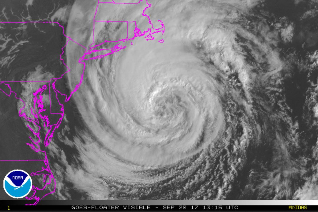 Tropicast: Boston Radar
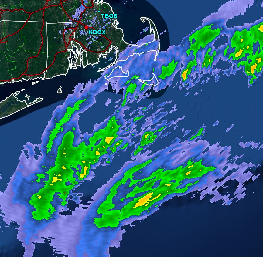
Re: Jose
Posted: Thu Sep 21, 2017 8:18 am
by Tropical Inspector
Thursday Morning UpdateJose stationary, weakeningThe Weather SituationJose continues to slowly weaken. It is still bringing breezes and rain bands to extreme SE Massachusetts.
Current Tropical WeatherAs of 8:00 AM EDT Jose was centered at 39.6 N / 68.1 W or 150 miles SE of Nantucket, MA. It was stationary. Top sustained winds are estimated at 60 mph. Pressure was estimated at 982 MB.
Tropical Weather Forecast:Jose will loop to the south and weaken soon. It will lose strength and become extratropical as it stays over colder water. The main effects will be high surf / strong rip currents. Some rain bands are over southern New England.
Tropicast: Visible Satellite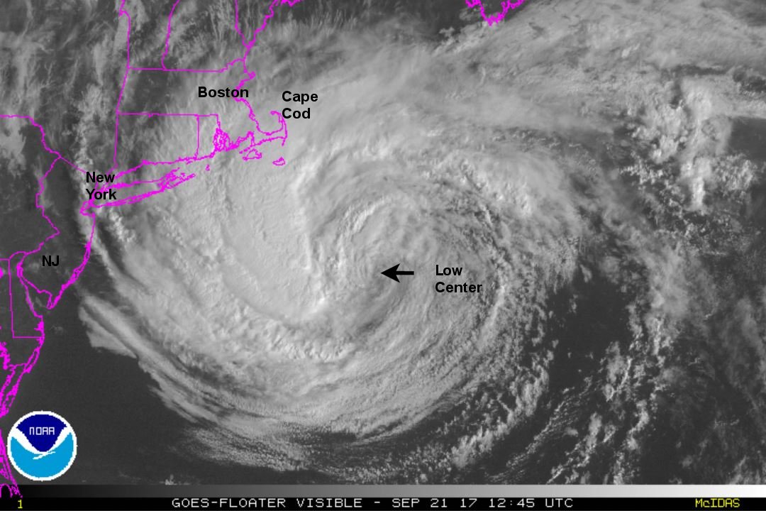 Tropicast: Boston Radar
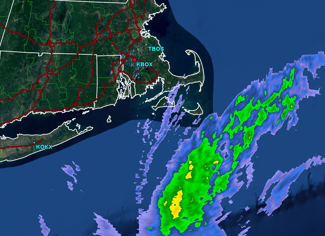
Re: Jose
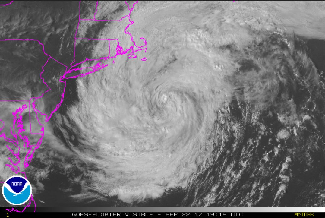
Posted: Fri Sep 22, 2017 2:45 pm
by Tropical Inspector
Friday Afternoon Update
Jose post tropical, weakening
The Weather Situation
Jose became post tropical yesterday and now is winding slowly down SSE of Cape Cod.
Current Tropical Weather
As of 2:00 PM EDT Jose was centered at 39.3 N / 69.3 W or 135 miles SSE of Nantucket, MA. It was stationary. Top sustained winds are estimated at 45 mph. Pressure was estimated at 995 MB.
Tropical Weather Forecast:
Jose is weakening as a non tropical system. The main effects will be high surf / strong rip currents.
Tropicast: Visible Satellite