Henriette

Post Reply
User avatar
Tropical Inspector
Site Admin
Site Admin
Posts: 3731
Joined: Tue Feb 20, 2007 2:28 pm
Antispam: no
Location: Under a palm tree
Contact:

Henriette

Post by Tropical Inspector »

Thursday Evening Update

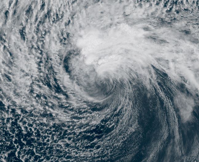
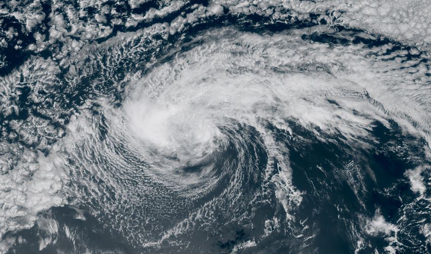
Henriette near cool water
Henriette currently only has minimal convection near its core. The large field of strato-cumulus clouds to the north is indicative of cooler ocean water temperatures limiting its strength.

The Weather Situation
SUMMARY OF 1100 AM HST...2100 UTC...INFORMATION
-----------------------------------------------
LOCATION...18.9N 136.8W
ABOUT 1195 MI...1920 KM E OF HILO HAWAII
MAXIMUM SUSTAINED WINDS...45 MPH...75 KM/H
PRESENT MOVEMENT...W OR 280 DEGREES AT 16 MPH...26 KM/H
MINIMUM CENTRAL PRESSURE...1006 MB...29.71 INCHES

Tropicast: Visible RAMMB Cira-Slider Thursday Afternoon
Image

Tropical Weather Forecast:
Henriette is near chilly water which is limiting intensification. It will also battle some dry air. It eventually will be closer to warmer water as it tracks WNW north of Hawaii. Intensification will be determined if it can survive through those harsh conditions.
Rich Johnson
LinkedIn: https://www.linkedin.com/in/richjohnsonmeteorologist/
AMS Certified Broadcast Meteorologist (CBM) - Hurricane Expert
User avatar
Tropical Inspector
Site Admin
Site Admin
Posts: 3731
Joined: Tue Feb 20, 2007 2:28 pm
Antispam: no
Location: Under a palm tree
Contact:

Re: Henriette

Post by Tropical Inspector »

Friday Evening Update

Henriette is a weak low
The dry air and cool water has taken a toll on Henriette causing the convection near the low center to weaken. Some convection is limited to the north.

The Weather Situation
SUMMARY OF 1100 AM HST...2100 UTC...INFORMATION
-----------------------------------------------
LOCATION...19.9N 143.0W
ABOUT 785 MI...1265 KM E OF HILO HAWAII
MAXIMUM SUSTAINED WINDS...35 MPH...55 KM/H
PRESENT MOVEMENT...WNW OR 285 DEGREES AT 17 MPH...28 KM/H
MINIMUM CENTRAL PRESSURE...1009 MB...29.80 INCHES

Tropicast: Visible RAMMB Cira-Slider Friday Afternoon
Image

Tropical Weather Forecast:
Henriette may regain some strength in a few days north of Hawaii as it encounters warmer water and less dry air.
Rich Johnson
LinkedIn: https://www.linkedin.com/in/richjohnsonmeteorologist/
AMS Certified Broadcast Meteorologist (CBM) - Hurricane Expert
User avatar
Tropical Inspector
Site Admin
Site Admin
Posts: 3731
Joined: Tue Feb 20, 2007 2:28 pm
Antispam: no
Location: Under a palm tree
Contact:

Re: Henriette

Post by Tropical Inspector »

Sunday Late Afternoon Update

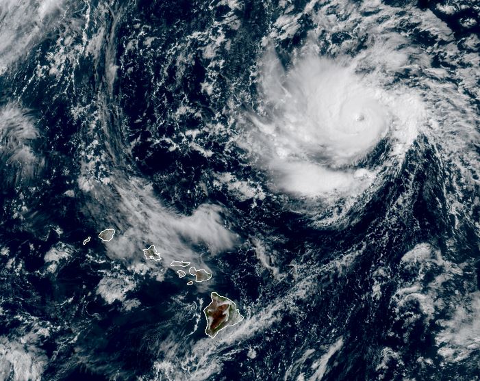
Henriette rapidly strengthens
Satellite imagery shows that an eyewall has rapidly formed over the past few hours indicating hurricane strength.

The Weather Situation
SUMMARY OF 1100 AM HST...2100 UTC...INFORMATION
-----------------------------------------------
LOCATION...25.7N 152.5W
ABOUT 445 MI...720 KM NNE OF HILO HAWAII
ABOUT 455 MI...735 KM NE OF HONOLULU HAWAII
MAXIMUM SUSTAINED WINDS...80 MPH...130 KM/H
PRESENT MOVEMENT...NW OR 315 DEGREES AT 17 MPH...28 KM/H
MINIMUM CENTRAL PRESSURE...990 MB...29.24 INCHES

Tropicast: Visible RAMMB Cira-Slider Sunday Late Afternoon
Image

Tropical Weather Forecast:
Henriette has moved past the dry air and is now encountering more favorable development conditions. It will continue to move NW away from Hawaii. Larger than average surf may be encountered on the north shores of especially the western islands.

NHC Advisory
https://www.nhc.noaa.gov/text/refresh/H ... 031.shtml?

NHC Track
https://www.nhc.noaa.gov/refresh/graphi ... e#contents
Rich Johnson
LinkedIn: https://www.linkedin.com/in/richjohnsonmeteorologist/
AMS Certified Broadcast Meteorologist (CBM) - Hurricane Expert
Post Reply

Return to “2025 Eastern / Central Pacific Hurricane Updates”

Who is online

Users browsing this forum: No registered users and 8 guests