Hilary

Tropical cyclone archives of the 2023 pacific hurricane season
Post Reply
User avatar
Tropical Inspector
Site Admin
Site Admin
Posts: 3581
Joined: Tue Feb 20, 2007 2:28 pm
Antispam: no
Location: Under a palm tree
Contact:

Hilary

Post by Tropical Inspector »

Friday Evening Update

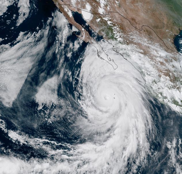
Hilary heading toward west central Baja
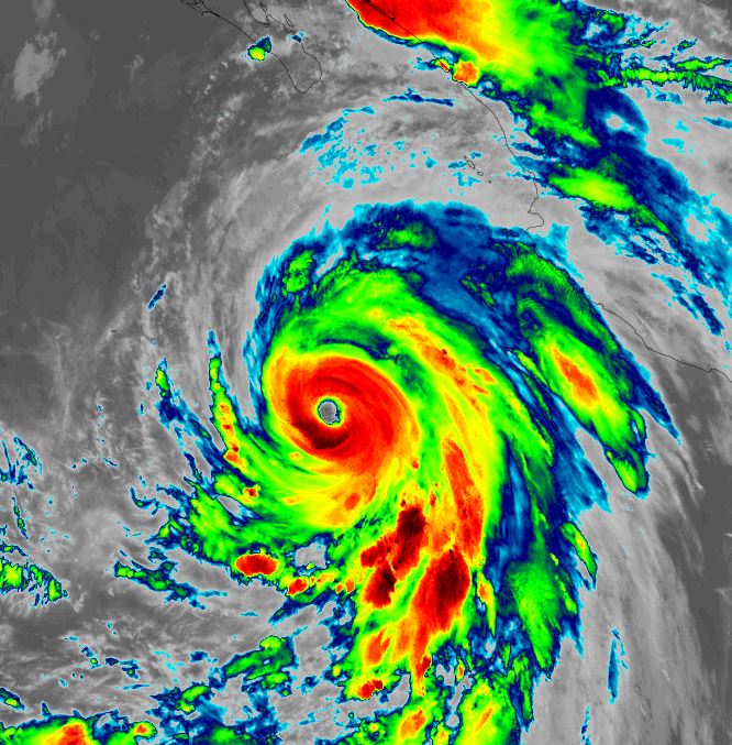
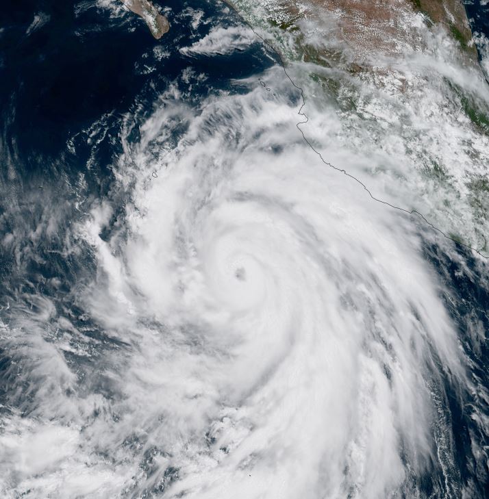
Outer rain bands from Hilary are moving over Los Cabos. Satellite imagery shows the strongest part of the eyewall on the SE side of the circulation.
The western Baja will see storm surge, hurricane force winds, flash flooding and mudslides. See the official NHC advisory for the details of these hazards.

The Weather Situation
SUMMARY OF 600 PM MDT...0000 UTC...INFORMATION
----------------------------------------------
LOCATION...19.1N 112.4W
ABOUT 95 MI...150 KM WNW OF SOCORRO ISLAND
ABOUT 310 MI...495 KM SSW OF CABO SAN LUCAS MEXICO
MAXIMUM SUSTAINED WINDS...130 MPH...215 KM/H
PRESENT MOVEMENT...NW OR 325 DEGREES AT 12 MPH...19 KM/H
MINIMUM CENTRAL PRESSURE...948 MB...28.00 INCHES

Tropicast: Visible satellite Friday afternoon 3 pm pdt
Image

Tropicast: IR satellite Thursday night 1 am pdt
Image

Tropicast: Visible satellite Thursday afternoon 12:30 pm pdt
Image

Tropical Weather Forecast:
Hilary will be a hurricane as it affects the west central coast of the Baja later in the day Saturday into Sunday morning. It will continue northward over southern California Sunday night into Monday morning. The greatest threat to southern California will be heavy rainfall with flash flooding and mudslides.
Rich Johnson
Twitter: https://twitter.com/richjohnsonwx
Certified Broadcast Meteorologist - Hurricane Expert
User avatar
Tropical Inspector
Site Admin
Site Admin
Posts: 3581
Joined: Tue Feb 20, 2007 2:28 pm
Antispam: no
Location: Under a palm tree
Contact:

Re: Hilary

Post by Tropical Inspector »

Saturday Morning Update

The Weather Situation
SUMMARY OF 600 AM MDT...1200 UTC...INFORMATION
----------------------------------------------
LOCATION...21.5N 113.4W
ABOUT 240 MI...390 KM WSW OF THE SOUTHERN TIP OF BAJA CALIFORNIA
ABOUT 490 MI...790 KM SSE OF PUNTA EUGENIA MEXICO
MAXIMUM SUSTAINED WINDS...130 MPH...215 KM/H
PRESENT MOVEMENT...NNW OR 335 DEGREES AT 13 MPH...20 KM/H
MINIMUM CENTRAL PRESSURE...943 MB...27.85 INCHES

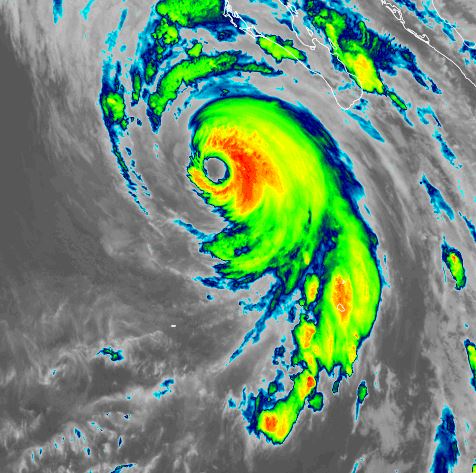
Tropicast: IR satellite
Image
Rich Johnson
Twitter: https://twitter.com/richjohnsonwx
Certified Broadcast Meteorologist - Hurricane Expert
User avatar
Tropical Inspector
Site Admin
Site Admin
Posts: 3581
Joined: Tue Feb 20, 2007 2:28 pm
Antispam: no
Location: Under a palm tree
Contact:

Re: Hilary

Post by Tropical Inspector »

Saturday Late Afternoon Update

Hilary weakens considerably
Satellite imagery showing considerable warming of the cloud tops near the eyewall of Hilary. The latest recon also measured a top wind of 94 kts at flight level. This wind from 700mb would extrapolate to stronger winds at the surface. At the same time, colder water west of the Baja would make a more stable boundary layer inhibiting the strongest winds from mixing to the surface. So IMHO, the winds are weaker than the official classification.

SUMMARY OF 1200 PM MDT...1800 UTC...INFORMATION
-----------------------------------------------
LOCATION...22.8N 113.9W
ABOUT 350 MI...570 KM SSE OF PUNTA EUGENIA MEXICO
ABOUT 710 MI...1145 KM SSE OF SAN DIEGO CALIFORNIA
MAXIMUM SUSTAINED WINDS...115 MPH...185 KM/H
PRESENT MOVEMENT...NNW OR 345 DEGREES AT 16 MPH...26 KM/H
MINIMUM CENTRAL PRESSURE...958 MB...28.32 INCHES

Tropicast: Visible satellite
Image

Tropical Weather Forecast:
Hilary will be a hurricane as it affects the west central coast of the Baja later this evening into Sunday morning. It will continue northward over southern California Sunday night into Monday morning. The greatest threat to southern California will be heavy rainfall with flash flooding and mudslides.
Rich Johnson
Twitter: https://twitter.com/richjohnsonwx
Certified Broadcast Meteorologist - Hurricane Expert
User avatar
Tropical Inspector
Site Admin
Site Admin
Posts: 3581
Joined: Tue Feb 20, 2007 2:28 pm
Antispam: no
Location: Under a palm tree
Contact:

Re: Hilary

Post by Tropical Inspector »

Sunday Midday Update

Hilary now officially downgraded to a tropical storm
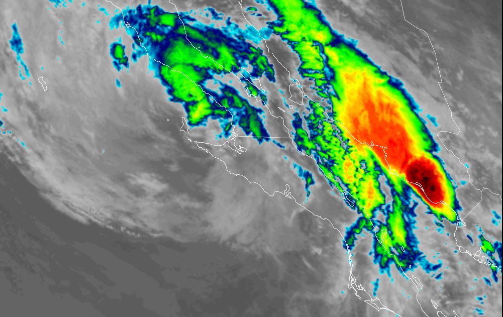
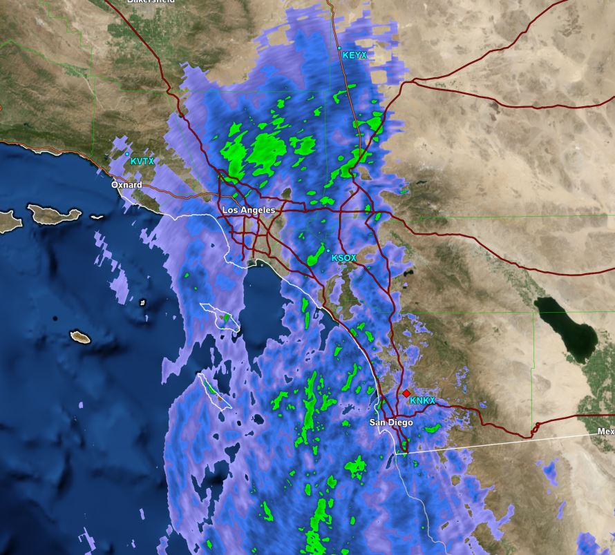
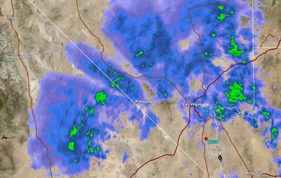
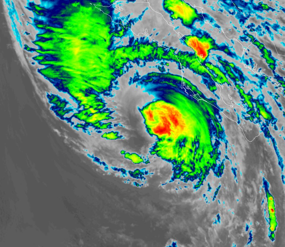
Satellite imagery shows Hillary much weaker. Officially at 70 mph sustained, but it is likely this is a generous estimate of windspeed. Looking at the second image below NHC called this a hurricane - without any organized eyewall. Rainfall has been falling over southern California for hours at this point. So far rain totals range mostly from 1/4' to 1" from San Diego to SE of Los Angeles. 1/2-1" reported near death valley toward Las Vegas.

SUMMARY OF 800 AM PDT...1500 UTC...INFORMATION
----------------------------------------------
LOCATION...29.7N 115.9W
ABOUT 220 MI...350 KM SSE OF SAN DIEGO CALIFORNIA
MAXIMUM SUSTAINED WINDS...70 MPH...110 KM/H
PRESENT MOVEMENT...NNW OR 345 DEGREES AT 25 MPH...41 KM/H
MINIMUM CENTRAL PRESSURE...984 MB...29.06 INCHES

Tropicast: Visible satellite 12 pm edt / 9 am pdt
Image

Tropicast: IR satellite 8 am edt / 5 am pdt
Image

Tropicast: San Diego Radar 8:15 am pdt
Image

Tropicast: Las Vegas Radar 8:15 am pdt
Image

Tropical Weather Forecast:
Hilary is continuing northward toward southern California and will move into the region this evening. The greatest threat to southern California remains heavy rainfall with flash flooding and mudslides.
NHC Advisory
https://www.nhc.noaa.gov/text/refresh/M ... 142.shtml?

NHC Track
https://www.nhc.noaa.gov/refresh/graphi ... e#contents
Rich Johnson
Twitter: https://twitter.com/richjohnsonwx
Certified Broadcast Meteorologist - Hurricane Expert
User avatar
Tropical Inspector
Site Admin
Site Admin
Posts: 3581
Joined: Tue Feb 20, 2007 2:28 pm
Antispam: no
Location: Under a palm tree
Contact:

Re: Hilary

Post by Tropical Inspector »

As expected, the main impacts to southern California was flash flooding. Near Los Angeles to San Diego generally 1.5-2.5 inches of rainfall was experienced. Mountainous areas, especially NE of Los Angeles received 2-4 inches of rainfall with totals over 5 inches. In the deserts to the east of Los Angeles 1-4 inches of rainfall was reported with isolated higher amounts.
Rich Johnson
Twitter: https://twitter.com/richjohnsonwx
Certified Broadcast Meteorologist - Hurricane Expert
Post Reply

Return to “2023 Eastern / Central Pacific Hurricane Archives”

Who is online

Users browsing this forum: No registered users and 34 guests