Danielle

Tropical cyclone archives of the 2022 atlantic hurricane season
Post Reply
User avatar
Tropical Inspector
Site Admin
Site Admin
Posts: 3694
Joined: Tue Feb 20, 2007 2:28 pm
Antispam: no
Location: Under a palm tree
Contact:

Danielle

Post by Tropical Inspector »

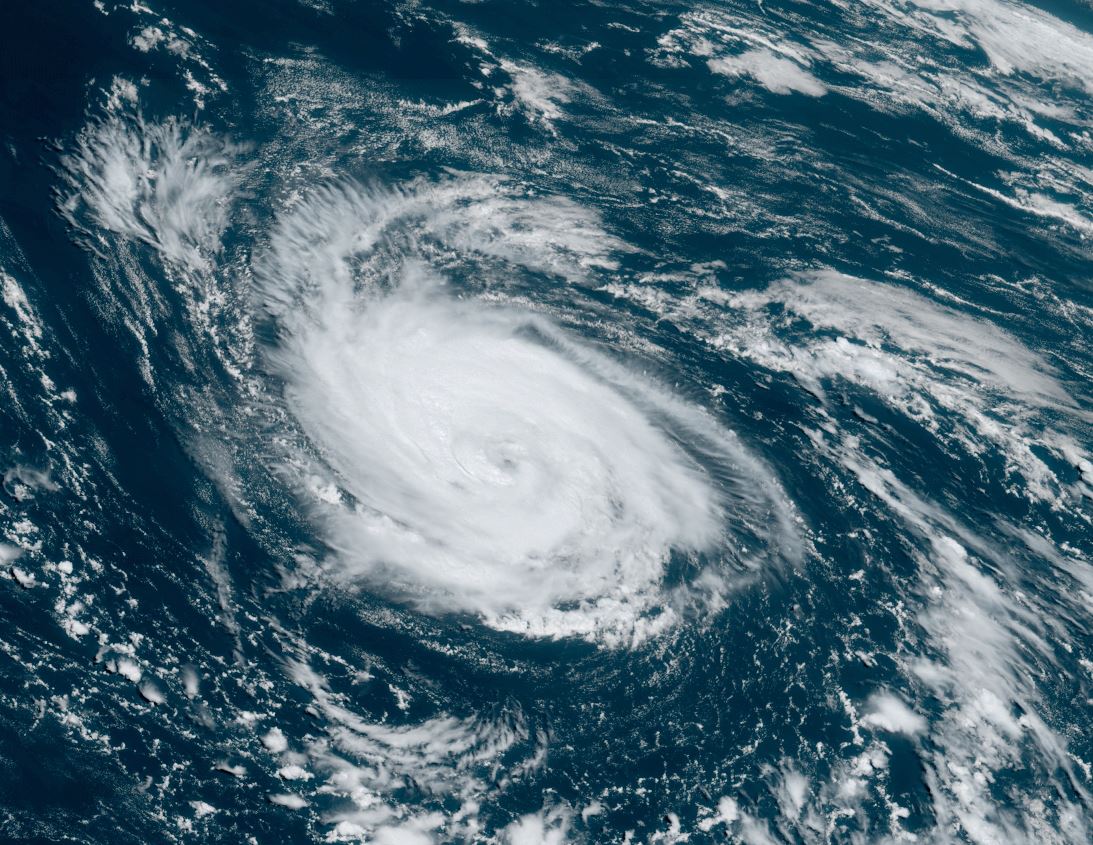
Thursday Night Update

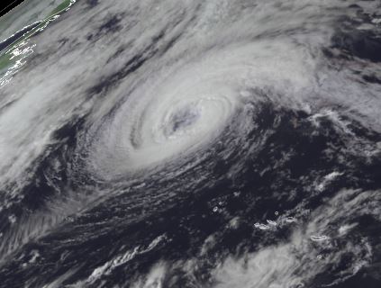
Danielle over the open North Atlantic
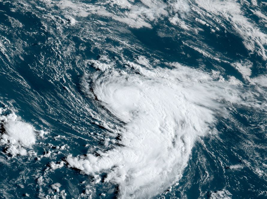
Deep convection is building around the center of circulation of Danielle and it is expected to become a hurricane. As of now, no landmasses are being affected.

The Weather Situation

SUMMARY OF 900 PM GMT...2100 UTC...INFORMATION
----------------------------------------------
LOCATION...38.1N 44.5W
ABOUT 950 MI...1530 KM W OF THE AZORES
MAXIMUM SUSTAINED WINDS...60 MPH...95 KM/H
PRESENT MOVEMENT...E OR 90 DEGREES AT 2 MPH...4 KM/H
MINIMUM CENTRAL PRESSURE...1005 MB...29.68 INCHES

Tropicast: Visible Satellite Thursday Afternoon
Image

Tropical Weather Forecast:
Danielle will drift slowly over the northern North Atlantic Ocean for the next few days before lifting northeast later this weekend.
Rich Johnson
Twitter: https://twitter.com/richjohnsonwx
Certified Broadcast Meteorologist - Hurricane Expert
User avatar
Tropical Inspector
Site Admin
Site Admin
Posts: 3694
Joined: Tue Feb 20, 2007 2:28 pm
Antispam: no
Location: Under a palm tree
Contact:

Re: Danielle

Post by Tropical Inspector »

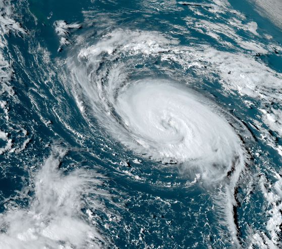
Friday Afternoon Update

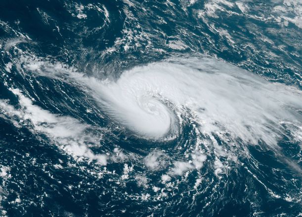
Danielle classified as a hurricane
There was only moderate deep convection northwest of the center and weak convection to the southeast. Despite this NHC raised the winds to 75 mph late this morning because of a 52 kt ASCAT wind found to the east of the center. Personally, I would not strengthened it quite as much that soon. By late this afternoon convection has finally wrapped around the center.

The Weather Situation

SUMMARY OF 300 PM GMT...1500 UTC...INFORMATION
----------------------------------------------
LOCATION...37.9N 43.3W
ABOUT 885 MI...1425 KM W OF THE AZORES
MAXIMUM SUSTAINED WINDS...75 MPH...120 KM/H
PRESENT MOVEMENT...W OR 260 DEGREES AT 1 MPH...2 KM/H
MINIMUM CENTRAL PRESSURE...992 MB...29.30 INCHES

Tropicast: Visible Satellite Friday Afternoon
Image

Tropical Weather Forecast:
Danielle will drift slowly over the northern North Atlantic Ocean for the next few days before lifting northeast later this weekend.
Rich Johnson
Twitter: https://twitter.com/richjohnsonwx
Certified Broadcast Meteorologist - Hurricane Expert
User avatar
Tropical Inspector
Site Admin
Site Admin
Posts: 3694
Joined: Tue Feb 20, 2007 2:28 pm
Antispam: no
Location: Under a palm tree
Contact:

Re: Danielle

Post by Tropical Inspector »

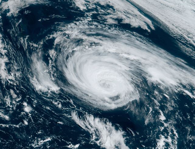
Saturday Afternoon Update

Danielle weakens slightly
Dry air has influenced Danielle and caused some slight weakening. Similar to yesterday, the weakest portion of the circulation is to the southeast of the center. Some marginal deep convection is seen to the north and southwest. Models indicate some strengthening is possible if Danielle can fight off the dry air.

The Weather Situation

SUMMARY OF 300 PM GMT...1500 UTC...INFORMATION
----------------------------------------------
LOCATION...38.1N 44.0W
ABOUT 925 MI...1485 KM W OF THE AZORES
MAXIMUM SUSTAINED WINDS...70 MPH...110 KM/H
PRESENT MOVEMENT...WNW OR 300 DEGREES AT 2 MPH...4 KM/H
MINIMUM CENTRAL PRESSURE...990 MB...29.24 INCHES

Tropicast: Visible Satellite
Image

Tropical Weather Forecast:
Danielle will pickup speed to the northeast by early next week and transition to an extratropical system over the northern North Atlantic Ocean.
Rich Johnson
Twitter: https://twitter.com/richjohnsonwx
Certified Broadcast Meteorologist - Hurricane Expert
User avatar
Tropical Inspector
Site Admin
Site Admin
Posts: 3694
Joined: Tue Feb 20, 2007 2:28 pm
Antispam: no
Location: Under a palm tree
Contact:

Re: Danielle

Post by Tropical Inspector »

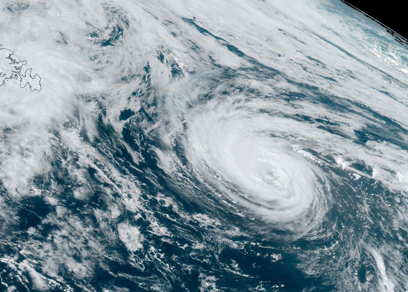
Sunday Late Afternoon Update

Danielle stronger
Satellite imagery shows the most impressive look at Danielle since forming. It has a solid central dense overcast. It currently is not affecting any landmasses.

The Weather Situation
SUMMARY OF 500 PM AST...2100 UTC...INFORMATION
----------------------------------------------
LOCATION...38.5N 45.1W
ABOUT 980 MI...1580 KM W OF THE AZORES
MAXIMUM SUSTAINED WINDS...85 MPH...140 KM/H
PRESENT MOVEMENT...N OR 360 DEGREES AT 2 MPH...4 KM/H
MINIMUM CENTRAL PRESSURE...979 MB...28.91 INCHES


Tropicast: Visible Satellite
Image

Tropical Weather Forecast:
Danielle will remain at the current strength or possibly strengthen briefly then transition to an extratropical system over the northern North Atlantic Ocean.
Rich Johnson
Twitter: https://twitter.com/richjohnsonwx
Certified Broadcast Meteorologist - Hurricane Expert
User avatar
Tropical Inspector
Site Admin
Site Admin
Posts: 3694
Joined: Tue Feb 20, 2007 2:28 pm
Antispam: no
Location: Under a palm tree
Contact:

Re: Danielle

Post by Tropical Inspector »

Monday Midday Update

Danielle weakens
Satellite imagery shows that deep convection no longer wraps around the whole circulation and I believe that the wind estimate by NHC is generous. Deep convection is noted on the western side of the circulation with a break to the northeast.

The Weather Situation
SUMMARY OF 300 PM GMT...1500 UTC...INFORMATION
----------------------------------------------
LOCATION...40.2N 43.9W
ABOUT 915 MI...1475 KM WNW OF THE AZORES
MAXIMUM SUSTAINED WINDS...85 MPH...140 KM/H
PRESENT MOVEMENT...NNE OR 30 DEGREES AT 8 MPH...13 KM/H
MINIMUM CENTRAL PRESSURE...976 MB...28.82 INCHES


Tropicast: Visible Satellite
Image

Tropical Weather Forecast:
Danielle has weakened over slightly cooler water. It will transition into an extratropical cyclone by mid week.
Rich Johnson
Twitter: https://twitter.com/richjohnsonwx
Certified Broadcast Meteorologist - Hurricane Expert
User avatar
Tropical Inspector
Site Admin
Site Admin
Posts: 3694
Joined: Tue Feb 20, 2007 2:28 pm
Antispam: no
Location: Under a palm tree
Contact:

Re: Danielle

Post by Tropical Inspector »

Tuesday Afternoon Update

Danielle weakens
Danielle is officially a minimal hurricane, although it seems a touch weaker as the eye has filled with clouds. Deep convection has been limited by the cooler sea surface temperatures in the area.

The Weather Situation
SUMMARY OF 300 PM GMT...1500 UTC...INFORMATION
----------------------------------------------
LOCATION...42.2N 41.2W
ABOUT 805 MI...1290 KM WNW OF THE AZORES
MAXIMUM SUSTAINED WINDS...75 MPH...120 KM/H
PRESENT MOVEMENT...ENE OR 70 DEGREES AT 6 MPH...9 KM/H
MINIMUM CENTRAL PRESSURE...986 MB...29.12 INCHES


Tropicast: Visible Satellite
Image

Tropical Weather Forecast:
Danielle will be transitioning into an extratropical cyclone during the next 24-36 hours.
Rich Johnson
Twitter: https://twitter.com/richjohnsonwx
Certified Broadcast Meteorologist - Hurricane Expert
User avatar
Tropical Inspector
Site Admin
Site Admin
Posts: 3694
Joined: Tue Feb 20, 2007 2:28 pm
Antispam: no
Location: Under a palm tree
Contact:

Re: Danielle

Post by Tropical Inspector »

Wednesday Afternoon Update

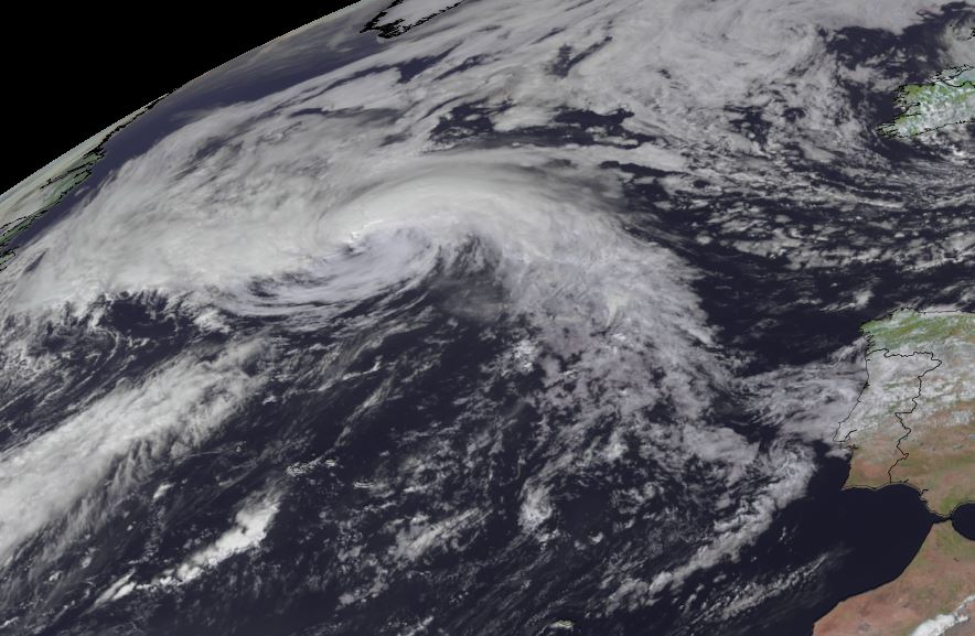
Danielle still impressive on satellite imagery
Deep convection near the circulation center is warming and moving farther from the center. This indicates transitioning to an extratropical cyclone. Despite this, Danielle has an impressive satellite impression as it continues to by fueled by the Gulf Stream.

The Weather Situation
SUMMARY OF 300 PM GMT...1500 UTC...INFORMATION
----------------------------------------------
LOCATION...43.7N 36.3W
ABOUT 625 MI...1005 KM NW OF THE AZORES
MAXIMUM SUSTAINED WINDS...80 MPH...130 KM/H
PRESENT MOVEMENT...NE OR 55 DEGREES AT 16 MPH...26 KM/H
MINIMUM CENTRAL PRESSURE...972 MB...28.71 INCHES


Tropicast: Visible Satellite
Image

Tropical Weather Forecast:
Danielle is becoming an extratropical cyclone and should complete the transition by Thursday.
Rich Johnson
Twitter: https://twitter.com/richjohnsonwx
Certified Broadcast Meteorologist - Hurricane Expert
User avatar
Tropical Inspector
Site Admin
Site Admin
Posts: 3694
Joined: Tue Feb 20, 2007 2:28 pm
Antispam: no
Location: Under a palm tree
Contact:

Re: Danielle

Post by Tropical Inspector »

Thursday Afternoon Update

Danielle now post tropical


The Weather Situation
SUMMARY OF 300 PM GMT...1500 UTC...INFORMATION
----------------------------------------------
LOCATION...47.9N 31.0W
ABOUT 715 MI...1145 KM NNW OF THE AZORES
MAXIMUM SUSTAINED WINDS...65 MPH...100 KM/H
PRESENT MOVEMENT...NNE OR 20 DEGREES AT 14 MPH...22 KM/H
MINIMUM CENTRAL PRESSURE...973 MB...28.74 INCHES


Tropicast: Visible Satellite
Image

Tropical Weather Forecast:
Danielle is extratropical. It will meander toward the coast of Portugal over the next several days.
Rich Johnson
Twitter: https://twitter.com/richjohnsonwx
Certified Broadcast Meteorologist - Hurricane Expert
Post Reply

Return to “2022 Atlantic Hurricane Archives”

Who is online

Users browsing this forum: No registered users and 0 guests