Saturday Morning Update
TD2 will probably be upgraded today
The Weather Situation
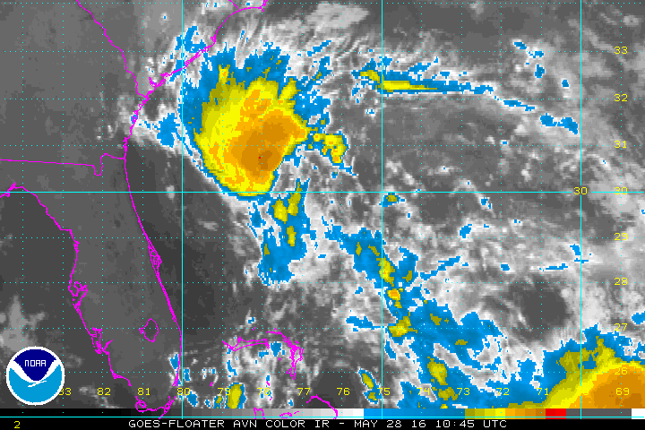
IR satellite imagery shows increased deep convection on the west side of the circulation which would suggest that TD 2 is crossing the threshold of becoming a minimal tropical storm.
Current Tropical Weather
As of 8 AM EDT Tropical Depression 2 was centered at 30.0 N /78.0 W or 225 miles SSE of Charleston,SC. It was moving NW at about 14 mph. Top sustained winds are estimated at 35 mph (NHC). Pressure was estimated at 1009 mb.
Tropical Weather Forecast:
TD 2 will move toward the coast of South Carolina today and be close to the coast by Sunday morning. It should then gradually lose tropical characteristics even if it doesn't move inland. The latest models have shifted from taking it well inland in South Carolina and now drift it up the coast. It will be near the South Carolina coast into Sunday and North Carolina coast Memorial Day.
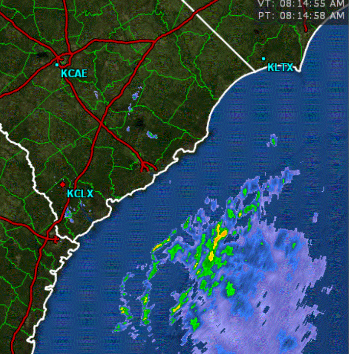
The greatest threat at this time would be for the increased threat of rip currents and building surf along the Southeast coast. Heavy rainfall is also likely as bands of heavy rain with gusty winds move into the coastal areas. Models at this time suggest TD 2 developing into a minimal tropical storm.
Tropicast: IR Satellite
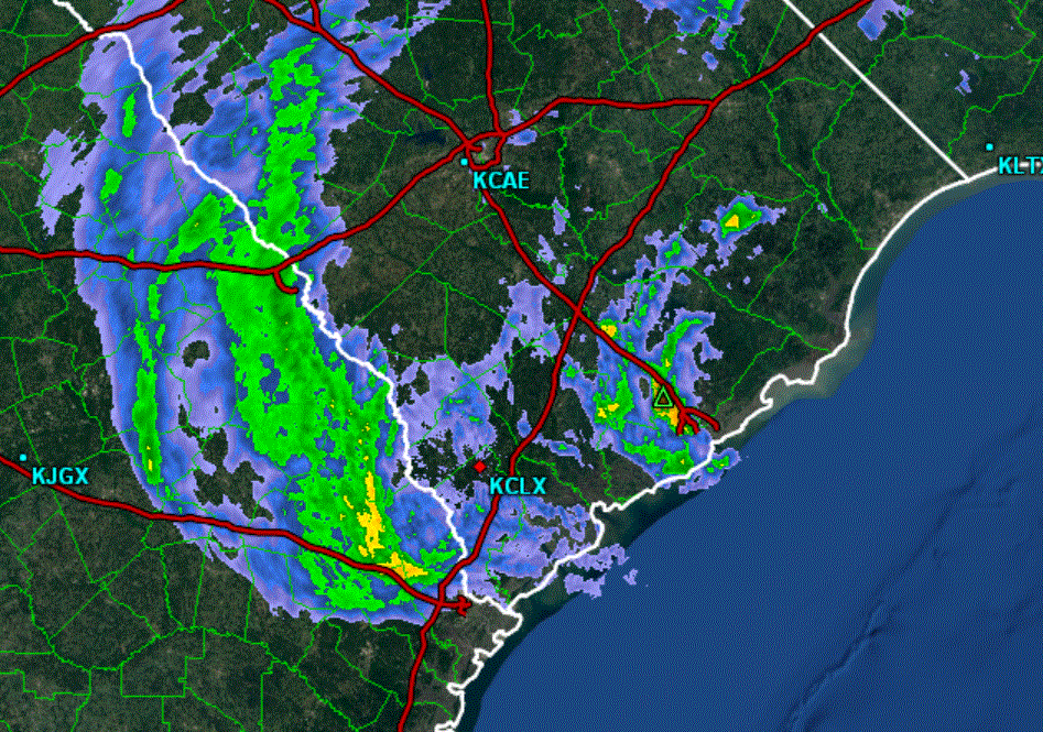
Tropicast: Charleston, SC Radar 8 am
Bonnie
Moderator: Florida Beach Gal
- Tropical Inspector
- Site Admin
- Posts: 3656
- Joined: Tue Feb 20, 2007 2:28 pm
- Antispam: no
- Location: Under a palm tree
- Contact:
Bonnie
Rich Johnson
Twitter: https://twitter.com/richjohnsonwx
Certified Broadcast Meteorologist - Hurricane Expert
Twitter: https://twitter.com/richjohnsonwx
Certified Broadcast Meteorologist - Hurricane Expert
- Tropical Inspector
- Site Admin
- Posts: 3656
- Joined: Tue Feb 20, 2007 2:28 pm
- Antispam: no
- Location: Under a palm tree
- Contact:
Re: Tropical Depression 2
Saturday Midday Update
TD2 will probably be upgraded today
The Weather Situation
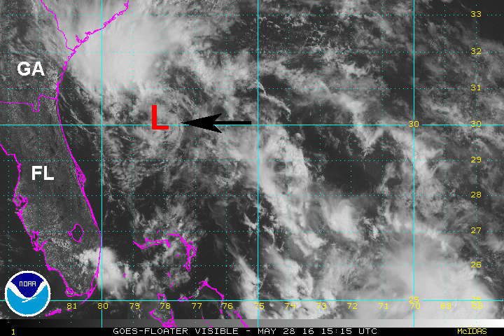
The center of circulation is on the southeast edge of the convection. At this point there may be some gusts to near 40 mph under the convection, but the circulation is still somewhat weak. Some organization may occur as TD 2 heads over the Gulf Stream waters today and tonight.
Current Tropical Weather
As of 11 AM EDT Tropical Depression 2 was centered at 30.3 N /78.5 W or 1955 miles SSE of Charleston,SC. It was moving NW at about 13 mph. Top sustained winds are estimated at 35 mph (NHC). Pressure was estimated at 1009 mb.
Tropical Weather Forecast:
Nothing new from the previous 8 AM forecast
Tropicast: Visible Satellite
Rich Johnson
Twitter: https://twitter.com/richjohnsonwx
Certified Broadcast Meteorologist - Hurricane Expert
Twitter: https://twitter.com/richjohnsonwx
Certified Broadcast Meteorologist - Hurricane Expert
- Tropical Inspector
- Site Admin
- Posts: 3656
- Joined: Tue Feb 20, 2007 2:28 pm
- Antispam: no
- Location: Under a palm tree
- Contact:
Re: Bonnie
Sunday Morning Update
Bonnie on the South Carolina coast
The Weather Situation
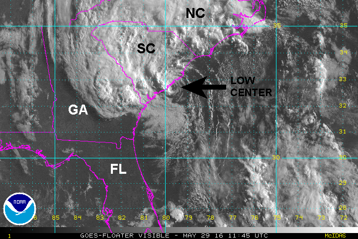
Bonnie was upgraded to a tropical storm 5pm edt Saturday. Winds increased to 45 mph by 11 pm last night. Bonnie is now on the coast and has been downgraded to a tropical depression. The heaviest rainfall is on the west side of the circulation along the Savannah river valley with additional rain north of the low.
Current Tropical Weather
As of 8 AM EDT Tropical Depression Bonnie was centered at 32.7 N /79.6 W or 25 miles ESE of Charleston, SC or 80 miles WSW of Myrtle Beach , SC . It was moving north at about 9 mph. Top sustained winds are estimated at 35 mph (NHC). Pressure was estimated at 1009 mb.
Tropical Weather Forecast:
Bonnie will move north, then northeast along the South Carolina coast today and southeast North Carolina coast on Memorial day. The main threat is continued heavy rainfall.
Tropicast: Visible Satellite
Tropicast: Charleston, SC Radar 8 am
Rich Johnson
Twitter: https://twitter.com/richjohnsonwx
Certified Broadcast Meteorologist - Hurricane Expert
Twitter: https://twitter.com/richjohnsonwx
Certified Broadcast Meteorologist - Hurricane Expert
- Tropical Inspector
- Site Admin
- Posts: 3656
- Joined: Tue Feb 20, 2007 2:28 pm
- Antispam: no
- Location: Under a palm tree
- Contact:
Re: Bonnie
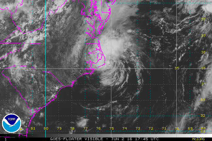
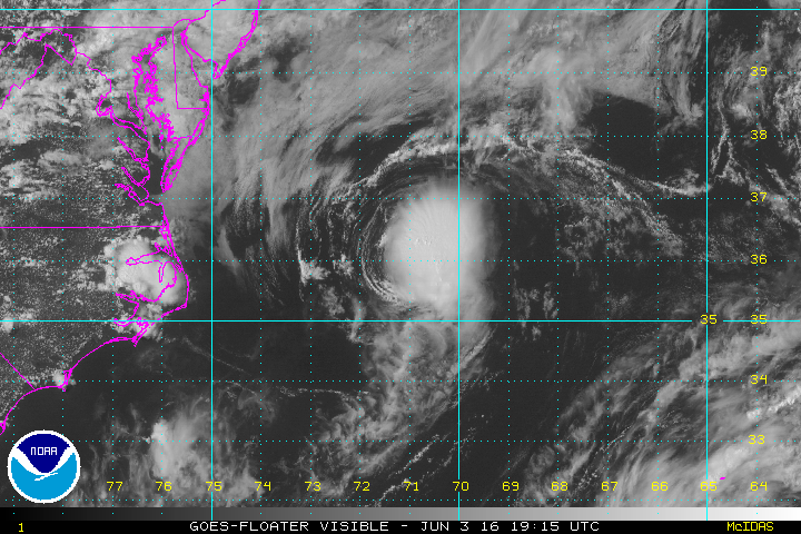
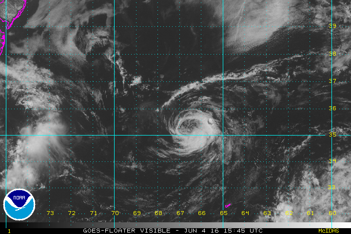
I have been updating Bonnie on my Facebook page the last few days. Yesterday Bonnie was classified as a tropical storm again after moving inland over the eastern Carolinas for a few days. As of 11 am edt today, Bonnie is now again a tropical depression and will move into the open Atlantic well north of Bermuda.
Tropicast: Visible Satellite 1:45pm edt Thursday
Tropicast: Visible Satellite 3:15pm edt Friday
Tropicast: Visible Satellite 11:45am edt Saturday
Tropicast: Visible Satellite 1:45pm edt Thursday
Tropicast: Visible Satellite 3:15pm edt Friday
Tropicast: Visible Satellite 11:45am edt Saturday
Rich Johnson
Twitter: https://twitter.com/richjohnsonwx
Certified Broadcast Meteorologist - Hurricane Expert
Twitter: https://twitter.com/richjohnsonwx
Certified Broadcast Meteorologist - Hurricane Expert
Who is online
Users browsing this forum: No registered users and 0 guests