Gonzalo
Moderator: Florida Beach Gal
- Tropical Inspector
- Site Admin

- Posts: 3819
- Joined: Tue Feb 20, 2007 2:28 pm
- Antispam: no
- Location: Under a palm tree
- Contact:
Re: Gonzalo
Pressure down to 940 mb at 8 am edt
Rich Johnson
LinkedIn: https://www.linkedin.com/in/richjohnsonmeteorologist/
AMS Certified Broadcast Meteorologist (CBM) - Hurricane Expert
LinkedIn: https://www.linkedin.com/in/richjohnsonmeteorologist/
AMS Certified Broadcast Meteorologist (CBM) - Hurricane Expert
- Tropical Inspector
- Site Admin

- Posts: 3819
- Joined: Tue Feb 20, 2007 2:28 pm
- Antispam: no
- Location: Under a palm tree
- Contact:
Re: Gonzalo
Thursday Afternoon Update
Bermuda targeted by Gonzalo
The Weather Situation:
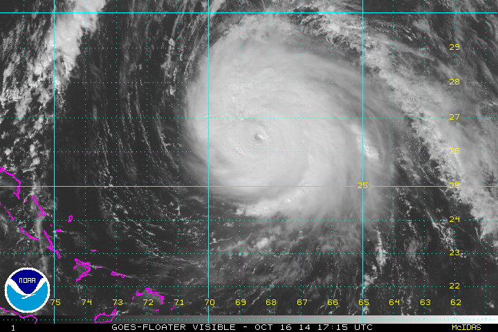
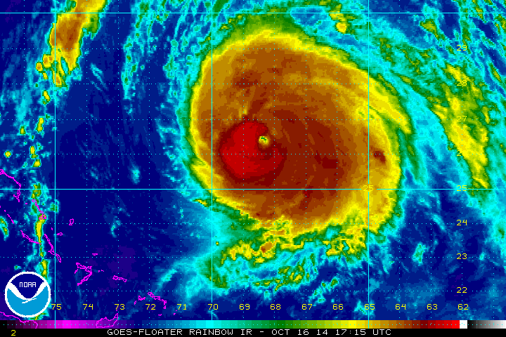
Our twitter and facebook updates from earlier this morning indicated that we believed a little more strengthening would be possible before Gonzalo weakened. This has indeed occurred as the hurricane was officially "upped' to 145 mph late this morning. This will be close to the top strength as it accelerates toward Bermuda tonight. Dangerous, large swell will arrive in Bermuda early Friday morning and continue all day.
Current Weather:
As of 2 PM EDT / 2 PM AST Hurricane Gonzalo was centered at 25.3 N / 68.7 W or 540 miles SSW of Bermuda. It was moving north at about 10 mph. Top sustained winds are estimated at 145 mph. Pressure was estimated at 942 mb.
Tropical Weather Forecast:
Gonzalo will be very close to Bermuda Friday. Some effects will be seen starting tonight. It will rapidly accelerate and be near Newfoundland Saturday night. Interests in Bermuda and Newfoundland should follow Gonzalo closely. All preparations should be completed by dusk tonight in Bermuda.
Tropicast: Atlantic Visible floater satellite
Tropicast: Atlantic Rainbow floater satellite
Bermuda targeted by Gonzalo
The Weather Situation:
Our twitter and facebook updates from earlier this morning indicated that we believed a little more strengthening would be possible before Gonzalo weakened. This has indeed occurred as the hurricane was officially "upped' to 145 mph late this morning. This will be close to the top strength as it accelerates toward Bermuda tonight. Dangerous, large swell will arrive in Bermuda early Friday morning and continue all day.
Current Weather:
As of 2 PM EDT / 2 PM AST Hurricane Gonzalo was centered at 25.3 N / 68.7 W or 540 miles SSW of Bermuda. It was moving north at about 10 mph. Top sustained winds are estimated at 145 mph. Pressure was estimated at 942 mb.
Tropical Weather Forecast:
Gonzalo will be very close to Bermuda Friday. Some effects will be seen starting tonight. It will rapidly accelerate and be near Newfoundland Saturday night.
Tropicast: Atlantic Visible floater satellite

Tropicast: Atlantic Rainbow floater satellite

Rich Johnson
LinkedIn: https://www.linkedin.com/in/richjohnsonmeteorologist/
AMS Certified Broadcast Meteorologist (CBM) - Hurricane Expert
LinkedIn: https://www.linkedin.com/in/richjohnsonmeteorologist/
AMS Certified Broadcast Meteorologist (CBM) - Hurricane Expert
- Tropical Inspector
- Site Admin

- Posts: 3819
- Joined: Tue Feb 20, 2007 2:28 pm
- Antispam: no
- Location: Under a palm tree
- Contact:
Re: Gonzalo
Thursday Night Update
Bermuda will start seeing effects by morning
The Weather Situation:
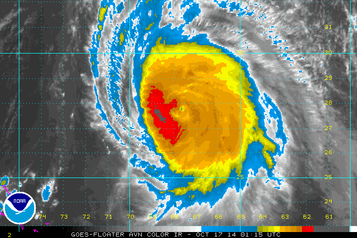
Satellite imagery and recon flight information show that Gonzalo is starting to slightly weaken. We are estimating winds a little lower than the official NHC estimate at 8 PM. This is a dangerous situation for Bermuda. Very high surf, storm surge and hurricane force winds are likely during the day Friday.
Current Weather:
As of 10 PM EDT / 10 PM AST Hurricane Gonzalo was centered at 27.6 N / 67.7 W or 360 miles SSW of Bermuda. It was moving NNE at about 10 mph. Top sustained winds are estimated at 135 mph (145 mph 8 PM NHC advisory). Pressure was estimated at 943 mb.
Tropical Weather Forecast:
Gonzalo will be close to Bermuda Friday afternoon. Some effects will be seen starting late tonight. It will rapidly accelerate and be near Newfoundland Saturday night. Interests in Bermuda and Newfoundland should follow Gonzalo closely.
Tropicast: Atlantic IR floater satellite
Bermuda will start seeing effects by morning
The Weather Situation:
Satellite imagery and recon flight information show that Gonzalo is starting to slightly weaken. We are estimating winds a little lower than the official NHC estimate at 8 PM. This is a dangerous situation for Bermuda. Very high surf, storm surge and hurricane force winds are likely during the day Friday.
Current Weather:
As of 10 PM EDT / 10 PM AST Hurricane Gonzalo was centered at 27.6 N / 67.7 W or 360 miles SSW of Bermuda. It was moving NNE at about 10 mph. Top sustained winds are estimated at 135 mph (145 mph 8 PM NHC advisory). Pressure was estimated at 943 mb.
Tropical Weather Forecast:
Gonzalo will be close to Bermuda Friday afternoon. Some effects will be seen starting late tonight. It will rapidly accelerate and be near Newfoundland Saturday night.
Tropicast: Atlantic IR floater satellite

Rich Johnson
LinkedIn: https://www.linkedin.com/in/richjohnsonmeteorologist/
AMS Certified Broadcast Meteorologist (CBM) - Hurricane Expert
LinkedIn: https://www.linkedin.com/in/richjohnsonmeteorologist/
AMS Certified Broadcast Meteorologist (CBM) - Hurricane Expert
- Tropical Inspector
- Site Admin

- Posts: 3819
- Joined: Tue Feb 20, 2007 2:28 pm
- Antispam: no
- Location: Under a palm tree
- Contact:
Re: Gonzalo
Friday Morning Update
Bermuda closing in on Bermuda
The Weather Situation:
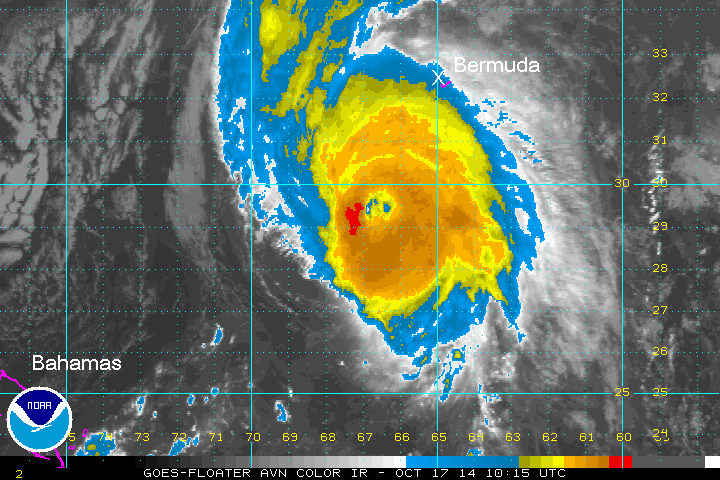
Satellite imagery confirms some cloud top warming indicating a little weakening overnight. A larger eye has formed and may pass over the islands later today. Westerly wind shear is apparent from the western side of the circulation. Wind shear in addition to colder sea water will weaken Gonzalo as it passes north of Bermuda and transform it into an extratropical system.
Wave models continue to show swell to about 35 feet near Bermuda later today and over 40 feet in the open Atlantic south of eastern Canada Saturday. :hurricane: Hurricane force winds, storm surge, and heavy rainfall can be expected today over Bermuda! Winds are currently under 30 mph, but will rise very rapidly with the approach of Gonzalo.
Current Weather:
As of 8 AM EDT / 8 AM AST Hurricane Gonzalo was centered at 29.9 N / 66.5 W or 195 miles SSW of Bermuda. It was moving NNE at about 15 mph. Top sustained winds are estimated at 130 mph. Pressure was estimated at 946 mb.
Tropical Weather Forecast:
Gonzalo will be at its closest to Bermuda late this afternoon. It will pass very near Bermuda. Tomorrow it will rapidly accelerate and be near Newfoundland Saturday night. Interests in Bermuda and Newfoundland should follow Gonzalo closely.
Tropicast: Atlantic IR floater satellite
Bermuda closing in on Bermuda
The Weather Situation:
Satellite imagery confirms some cloud top warming indicating a little weakening overnight. A larger eye has formed and may pass over the islands later today. Westerly wind shear is apparent from the western side of the circulation. Wind shear in addition to colder sea water will weaken Gonzalo as it passes north of Bermuda and transform it into an extratropical system.
Wave models continue to show swell to about 35 feet near Bermuda later today and over 40 feet in the open Atlantic south of eastern Canada Saturday. :hurricane: Hurricane force winds, storm surge, and heavy rainfall can be expected today over Bermuda! Winds are currently under 30 mph, but will rise very rapidly with the approach of Gonzalo.
Current Weather:
As of 8 AM EDT / 8 AM AST Hurricane Gonzalo was centered at 29.9 N / 66.5 W or 195 miles SSW of Bermuda. It was moving NNE at about 15 mph. Top sustained winds are estimated at 130 mph. Pressure was estimated at 946 mb.
Tropical Weather Forecast:
Gonzalo will be at its closest to Bermuda late this afternoon. It will pass very near Bermuda. Tomorrow it will rapidly accelerate and be near Newfoundland Saturday night.
Tropicast: Atlantic IR floater satellite

Rich Johnson
LinkedIn: https://www.linkedin.com/in/richjohnsonmeteorologist/
AMS Certified Broadcast Meteorologist (CBM) - Hurricane Expert
LinkedIn: https://www.linkedin.com/in/richjohnsonmeteorologist/
AMS Certified Broadcast Meteorologist (CBM) - Hurricane Expert
- Tropical Inspector
- Site Admin

- Posts: 3819
- Joined: Tue Feb 20, 2007 2:28 pm
- Antispam: no
- Location: Under a palm tree
- Contact:
Re: Gonzalo
Friday Midday Update
Gonzalo a little weaker
The Weather Situation:
Satellite shows the eye now cloud covered. This is a result of some increasing shear. Look for additional weakening later today.
Wave models continue to show swell to about 35 feet near Bermuda later today and over 40 feet in the open Atlantic south of eastern Canada Saturday. :hurricane: Hurricane force winds, storm surge, and heavy rainfall can be expected today over Bermuda! Winds are currently near 30 mph with higher gusts, but will rise very rapidly with the approach of Gonzalo.
Current Weather:
As of 11 AM EDT / 11 AM AST Hurricane Gonzalo was centered at 30.4 N / 66.1 W or 150 miles SSW of Bermuda. It was moving NNE at about 16 mph. Top sustained winds are estimated at 125 mph. Pressure was estimated at 947 mb.
Tropical Weather Forecast:
Gonzalo will be at its closest to Bermuda late this afternoon. It will pass very near Bermuda. Tomorrow it will rapidly accelerate and be near Newfoundland Saturday night. Interests in Bermuda and Newfoundland should follow Gonzalo closely.
Tropicast: Atlantic Visible floater satellite
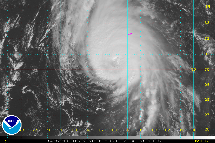
Gonzalo a little weaker
The Weather Situation:
Satellite shows the eye now cloud covered. This is a result of some increasing shear. Look for additional weakening later today.
Wave models continue to show swell to about 35 feet near Bermuda later today and over 40 feet in the open Atlantic south of eastern Canada Saturday. :hurricane: Hurricane force winds, storm surge, and heavy rainfall can be expected today over Bermuda! Winds are currently near 30 mph with higher gusts, but will rise very rapidly with the approach of Gonzalo.
Current Weather:
As of 11 AM EDT / 11 AM AST Hurricane Gonzalo was centered at 30.4 N / 66.1 W or 150 miles SSW of Bermuda. It was moving NNE at about 16 mph. Top sustained winds are estimated at 125 mph. Pressure was estimated at 947 mb.
Tropical Weather Forecast:
Gonzalo will be at its closest to Bermuda late this afternoon. It will pass very near Bermuda. Tomorrow it will rapidly accelerate and be near Newfoundland Saturday night.
Tropicast: Atlantic Visible floater satellite

Rich Johnson
LinkedIn: https://www.linkedin.com/in/richjohnsonmeteorologist/
AMS Certified Broadcast Meteorologist (CBM) - Hurricane Expert
LinkedIn: https://www.linkedin.com/in/richjohnsonmeteorologist/
AMS Certified Broadcast Meteorologist (CBM) - Hurricane Expert
- Tropical Inspector
- Site Admin

- Posts: 3819
- Joined: Tue Feb 20, 2007 2:28 pm
- Antispam: no
- Location: Under a palm tree
- Contact:
Re: Gonzalo
Friday Evening Update
Gonzalo near Bermuda
The Weather Situation:
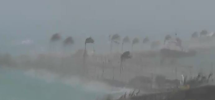
Radar shows the eye of Gonzalo just southwest of Bermuda. Winds and rain have picked up very quickly over the past few hours. At 4 PM EDT winds were 45 MPH with gusts to 58 MPH at the weather service in Bermuda The 5 PM EDT winds were 45 MPH with gusts to 67 MPH. The hurricane hunter aircraft recently reported a pressure now up to 950 MB. This indicates and slow and steady weakening.
Wave models show swell to over 40 feet in the open Atlantic south of eastern Canada Saturday. :hurricane: Hurricane force winds, storm surge, and heavy rainfall is beginning over Bermuda now!
Current Weather:
As of 5 PM EDT / 6 PM ADT Hurricane Gonzalo was centered at 31.7 N / 65.3 W or 50 miles SW of Bermuda. It was moving NNE at about 16 mph. Top sustained winds are estimated at 115 mph. Pressure was estimated at 949 mb.
Tropical Weather Forecast:
Gonzalo will be rapidly accelerating Saturday and be near Newfoundland Saturday night. Interests in Newfoundland should follow Gonzalo closely.
Tropicast: Atlantic Visible floater satellite
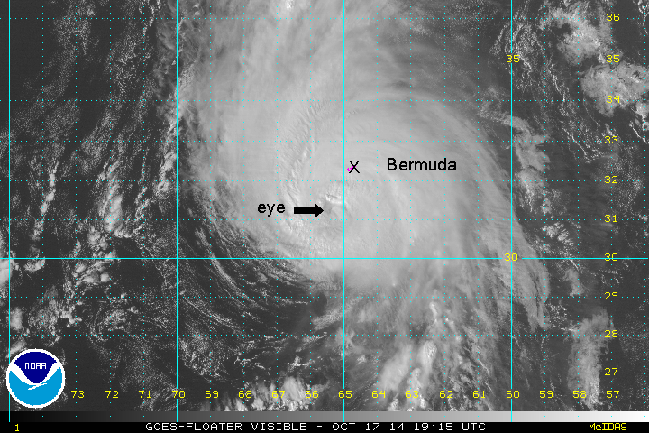
Tropicast: Hamilton Harbor Webcam (PTZ TV) 4:15 PM ADT
Tropicast: Bermuda Radar 5:33 PM ADT
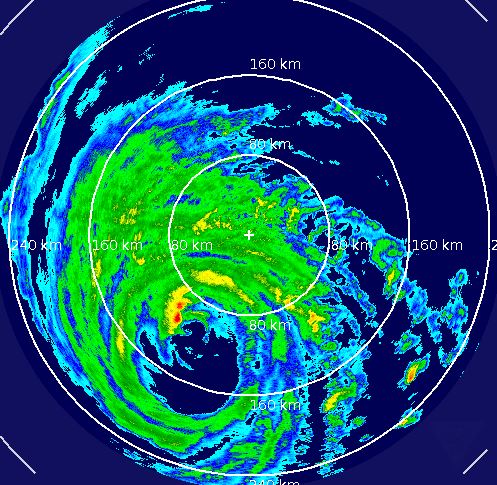
Gonzalo near Bermuda
The Weather Situation:
Radar shows the eye of Gonzalo just southwest of Bermuda. Winds and rain have picked up very quickly over the past few hours. At 4 PM EDT winds were 45 MPH with gusts to 58 MPH at the weather service in Bermuda The 5 PM EDT winds were 45 MPH with gusts to 67 MPH. The hurricane hunter aircraft recently reported a pressure now up to 950 MB. This indicates and slow and steady weakening.
Wave models show swell to over 40 feet in the open Atlantic south of eastern Canada Saturday. :hurricane: Hurricane force winds, storm surge, and heavy rainfall is beginning over Bermuda now!
Current Weather:
As of 5 PM EDT / 6 PM ADT Hurricane Gonzalo was centered at 31.7 N / 65.3 W or 50 miles SW of Bermuda. It was moving NNE at about 16 mph. Top sustained winds are estimated at 115 mph. Pressure was estimated at 949 mb.
Tropical Weather Forecast:
Gonzalo will be rapidly accelerating Saturday and be near Newfoundland Saturday night.
Tropicast: Atlantic Visible floater satellite

Tropicast: Hamilton Harbor Webcam (PTZ TV) 4:15 PM ADT

Tropicast: Bermuda Radar 5:33 PM ADT

Rich Johnson
LinkedIn: https://www.linkedin.com/in/richjohnsonmeteorologist/
AMS Certified Broadcast Meteorologist (CBM) - Hurricane Expert
LinkedIn: https://www.linkedin.com/in/richjohnsonmeteorologist/
AMS Certified Broadcast Meteorologist (CBM) - Hurricane Expert
- Tropical Inspector
- Site Admin

- Posts: 3819
- Joined: Tue Feb 20, 2007 2:28 pm
- Antispam: no
- Location: Under a palm tree
- Contact:
Re: Gonzalo
Current wind at 8 pm edt is 74 mph gusting to 96 mph at the bermuda weather service. Some gusts to 125 mph have been reported across the island.
Rich Johnson
LinkedIn: https://www.linkedin.com/in/richjohnsonmeteorologist/
AMS Certified Broadcast Meteorologist (CBM) - Hurricane Expert
LinkedIn: https://www.linkedin.com/in/richjohnsonmeteorologist/
AMS Certified Broadcast Meteorologist (CBM) - Hurricane Expert
- Tropical Inspector
- Site Admin

- Posts: 3819
- Joined: Tue Feb 20, 2007 2:28 pm
- Antispam: no
- Location: Under a palm tree
- Contact:
Re: Gonzalo
Friday Night Update
Gonzalo moving past Bermuda
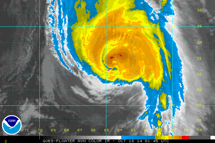
The Weather Situation:
Gonzalo raked the island of Bermuda with the eye is now passing to the northeast. A wind of 98 mph with a gust to 134 mph was reported at Commissioner's point at an elevated location. Another wind of 90 mph with a gust to 130 mph was reported at St. David's near the airport at an elevated location. Rainfall and winds will diminish tonight on Bermuda.
Wave models show swell to over 40 feet in the open Atlantic south of eastern Canada Saturday.
Current Weather:
As of 11 PM EDT / 12 AM ADT Hurricane Gonzalo was centered at 32.7 N / 64.5 W or 35 miles NNE of Bermuda. It was moving NNE at about 16 mph. Top sustained winds are estimated at 110 mph. Pressure was estimated at 951 mb.
Tropical Weather Forecast:
Gonzalo will be rapidly accelerating Saturday and be near Newfoundland Saturday night. Interests in Newfoundland should follow Gonzalo closely.
Tropicast: Atlantic IR floater satellite
Gonzalo moving past Bermuda
The Weather Situation:
Gonzalo raked the island of Bermuda with the eye is now passing to the northeast. A wind of 98 mph with a gust to 134 mph was reported at Commissioner's point at an elevated location. Another wind of 90 mph with a gust to 130 mph was reported at St. David's near the airport at an elevated location. Rainfall and winds will diminish tonight on Bermuda.
Wave models show swell to over 40 feet in the open Atlantic south of eastern Canada Saturday.
Current Weather:
As of 11 PM EDT / 12 AM ADT Hurricane Gonzalo was centered at 32.7 N / 64.5 W or 35 miles NNE of Bermuda. It was moving NNE at about 16 mph. Top sustained winds are estimated at 110 mph. Pressure was estimated at 951 mb.
Tropical Weather Forecast:
Gonzalo will be rapidly accelerating Saturday and be near Newfoundland Saturday night.
Tropicast: Atlantic IR floater satellite

Rich Johnson
LinkedIn: https://www.linkedin.com/in/richjohnsonmeteorologist/
AMS Certified Broadcast Meteorologist (CBM) - Hurricane Expert
LinkedIn: https://www.linkedin.com/in/richjohnsonmeteorologist/
AMS Certified Broadcast Meteorologist (CBM) - Hurricane Expert
- Tropical Inspector
- Site Admin

- Posts: 3819
- Joined: Tue Feb 20, 2007 2:28 pm
- Antispam: no
- Location: Under a palm tree
- Contact:
Re: Gonzalo
Saturday Morning Update
Gonzalo accelerating
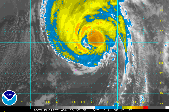
The Weather Situation:
Winds are calming down on Bermuda. Over the last few hours winds are down to about 30 mph with a few gusts to near 50 mph at elevated locations. Winds will continue to weaken this morning. Gonzalo will be over the open Atlantic today.
Wave models show swell to over 40 feet in the open Atlantic south of eastern Canada Saturday.
Current Weather:
As of 5 AM EDT / 6 AM ADT Hurricane Gonzalo was centered at 34.7 N / 63.2 W or 190 miles NNE of Bermuda / 980 miles SW Cape Grace, Newfoundland. It was moving NNE at about 22 mph. Top sustained winds are estimated at 105 mph. Pressure was estimated at 955 mb.
Tropical Weather Forecast:
Gonzalo will be near eastern Newfoundland tonight. Interests in Newfoundland should follow Gonzalo closely.
Tropicast: Atlantic IR floater satellite
Gonzalo accelerating
The Weather Situation:
Winds are calming down on Bermuda. Over the last few hours winds are down to about 30 mph with a few gusts to near 50 mph at elevated locations. Winds will continue to weaken this morning. Gonzalo will be over the open Atlantic today.
Wave models show swell to over 40 feet in the open Atlantic south of eastern Canada Saturday.
Current Weather:
As of 5 AM EDT / 6 AM ADT Hurricane Gonzalo was centered at 34.7 N / 63.2 W or 190 miles NNE of Bermuda / 980 miles SW Cape Grace, Newfoundland. It was moving NNE at about 22 mph. Top sustained winds are estimated at 105 mph. Pressure was estimated at 955 mb.
Tropical Weather Forecast:
Gonzalo will be near eastern Newfoundland tonight.
Tropicast: Atlantic IR floater satellite

Rich Johnson
LinkedIn: https://www.linkedin.com/in/richjohnsonmeteorologist/
AMS Certified Broadcast Meteorologist (CBM) - Hurricane Expert
LinkedIn: https://www.linkedin.com/in/richjohnsonmeteorologist/
AMS Certified Broadcast Meteorologist (CBM) - Hurricane Expert
- Tropical Inspector
- Site Admin

- Posts: 3819
- Joined: Tue Feb 20, 2007 2:28 pm
- Antispam: no
- Location: Under a palm tree
- Contact:
Re: Gonzalo
Winds down to 100 mph at 8 AM EDT.
Rich Johnson
LinkedIn: https://www.linkedin.com/in/richjohnsonmeteorologist/
AMS Certified Broadcast Meteorologist (CBM) - Hurricane Expert
LinkedIn: https://www.linkedin.com/in/richjohnsonmeteorologist/
AMS Certified Broadcast Meteorologist (CBM) - Hurricane Expert
- Tropical Inspector
- Site Admin

- Posts: 3819
- Joined: Tue Feb 20, 2007 2:28 pm
- Antispam: no
- Location: Under a palm tree
- Contact:
Re: Gonzalo
Saturday Night Update
Gonzalo SE of Nova Scotia
The Weather Situation:
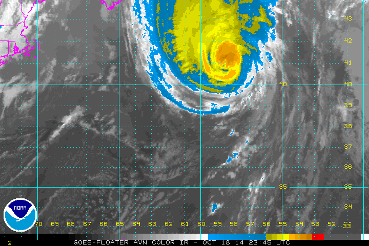
Gonzalo is losing its tropical characteristics It will clip past eastern Newfoundland tonight. It is accelerating across the north Atlantic at nearly 40 mph.
Current Weather:
As of 8 PM EDT / 9 PM ADT Hurricane Gonzalo was centered at 41.0 N /58.5 W or 470 miles SW of Cape Race Newfoundland. It was moving NNE at about 39 mph. Top sustained winds are estimated at 90 mph. Pressure was estimated at 966 mb.
Tropical Weather Forecast:
Gonzalo will become extratropical during the next 24 hours.
Tropicast: Atlantic IR floater satellite

Rich Johnson
LinkedIn: https://www.linkedin.com/in/richjohnsonmeteorologist/
AMS Certified Broadcast Meteorologist (CBM) - Hurricane Expert
LinkedIn: https://www.linkedin.com/in/richjohnsonmeteorologist/
AMS Certified Broadcast Meteorologist (CBM) - Hurricane Expert
- Tropical Inspector
- Site Admin

- Posts: 3819
- Joined: Tue Feb 20, 2007 2:28 pm
- Antispam: no
- Location: Under a palm tree
- Contact:
Re: Gonzalo
Sunday Morning Update
Gonzalo racing past Newfoundland
The Weather Situation:
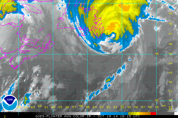
Gonzalo is moving at over 50 mph which is very fast for a tropical cyclone. The eastern half of Newfoundland has been getting rain and wind overnight, but will come to an end by this afternoon. This tropical cyclone still actually has a well defined eye which is extraordinary. It should rapidly become extratropical during the next 12 hours over colder water the the north Atlantic.
Current Weather:
As of 5 AM EDT / 6 AM ADT Hurricane Gonzalo was centered at 46.3 N /52.9 W or 30 miles SE of Cape Race Newfoundland. It was moving NNE at about 52 mph. Top sustained winds are estimated at 85 mph. Pressure was estimated at 969 mb.
Tropical Weather Forecast:
Gonzalo will become extratropical during the next 12 hours.
Tropicast: Atlantic IR floater satellite

Rich Johnson
LinkedIn: https://www.linkedin.com/in/richjohnsonmeteorologist/
AMS Certified Broadcast Meteorologist (CBM) - Hurricane Expert
LinkedIn: https://www.linkedin.com/in/richjohnsonmeteorologist/
AMS Certified Broadcast Meteorologist (CBM) - Hurricane Expert
Who is online
Users browsing this forum: No registered users and 12 guests