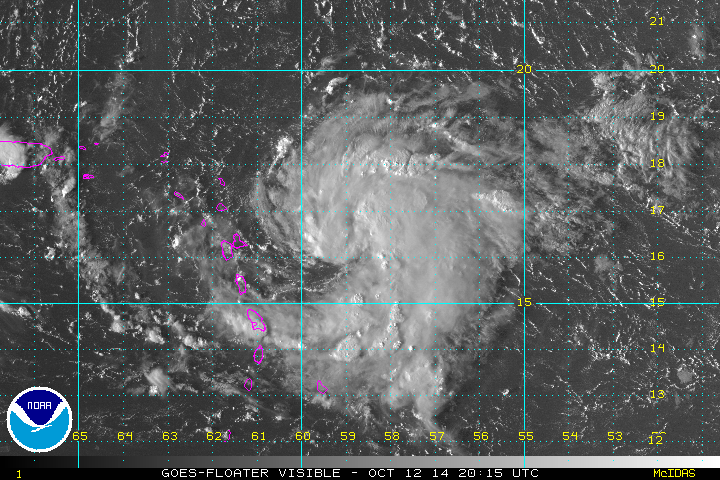
The Weather Situation:
A disturbed area of weather just east of the Leewards appears to be organized enough to be classified as a tropical depression. This system will likely move west across the northeastern Caribbean during the next few days then east of the Bahamas.
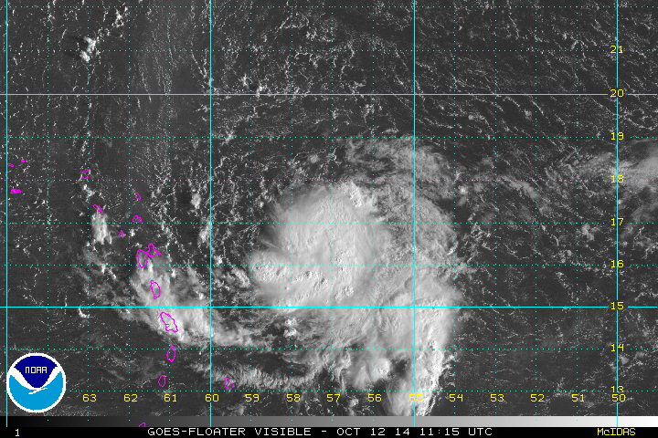
The Weather Situation:
Unofficially a tropical depression has formed east of the Leewards. The hurricane center has not classified it yet, but will once the recon gets there, IMO. In fact, I wouldn't be surprised if it is not a minimal tropical storm already. It appears to have a low level circulation with a ball of deep convection.
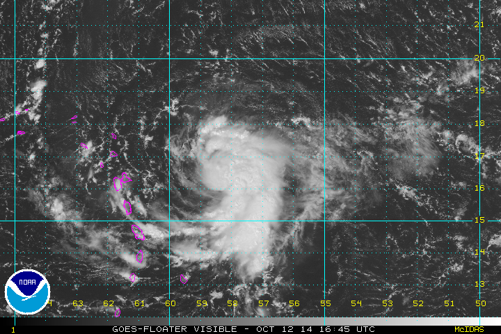
The Weather Situation:
I believe that we have a tropical storm east of the Leewards. The hurricane center is waiting for a recon to investigate today. If it looks a duck, swims like a duck, quacks like a duck........
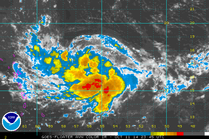
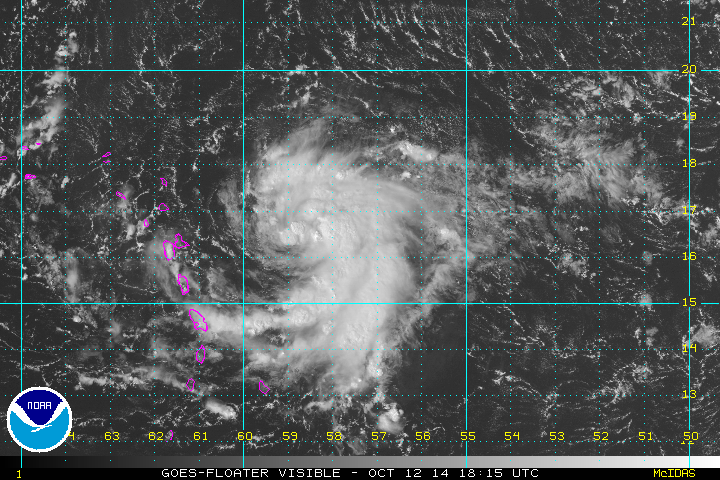
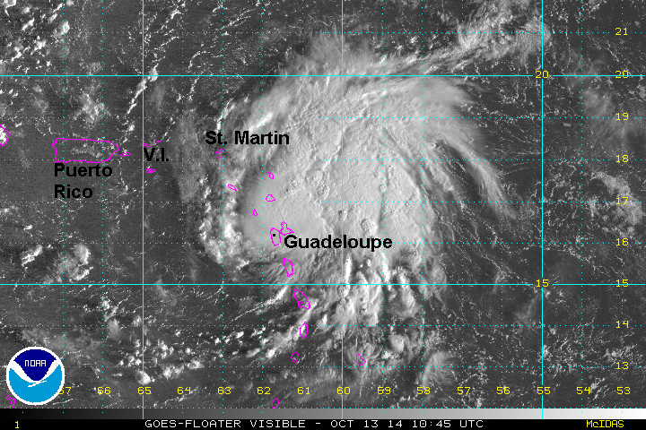
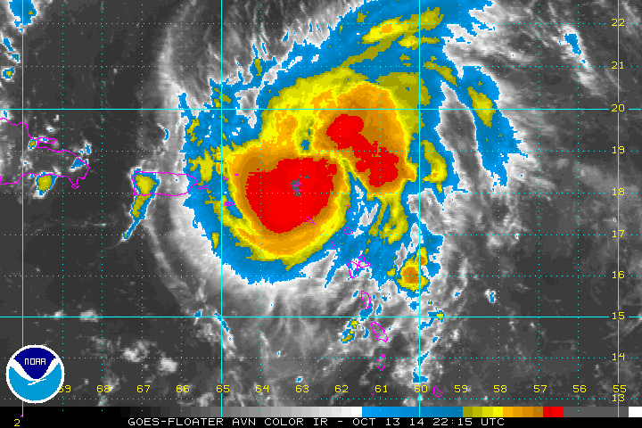
The Weather Situation:
As expected, the hurricane center named the disturbance east of the Leeward Islands. Deep convection continues to build over the center of the circulation which will allow strengthening. A rain band moved through the northern Windwards and Leewards earlier today. Look for heavy showers to increase overnight in the Leewards.
Current Weather:
As of 1:30 PM EDT / 1:30 PM AST Tropical storm Gonazlo was centered at 16.4 N / 58.94 W or about 200 miles east of Guadeloupe. It was moving west at about 10 mph. Top sustained winds are estimated at 40 mph. Pressure was estimated at 1009 mb.
Tropical Weather Forecast:
Tropical storm Gonzalo is expected to move through the northeastern Caribbean over the next few days. Gonzalo will be over the Leewards tomorrow morning. It will turn northward near eastern Puerto Rico by Tuesday morning then east of the Bahamas Wednesday. It is likely to become a hurricane.
The Weather Situation:
Heavy showers and storms remain east of the Leewards. Wind and heavy rain will pick up after midnight tonight into tomorrow morning across the Leewards. All preparations should be completed by this evening in the Leewards.
Current Weather:
As of 5 PM EDT / 5 PM AST Tropical storm Gonzalo was centered at 16.4 N / 59.5 W or about 125 miles east of Guadeloupe / 160 miles ESE of Antigua. It was moving west at about 12 mph. Top sustained winds are estimated at 45 mph. Pressure was estimated at 1009 mb.
Tropical Weather Forecast:
Tropical storm Gonzalo is expected to move through the northeastern Caribbean over the next few days. Gonzalo will be over the Leewards between Guadeloupe and Antigua tomorrow morning. It will turn northward near eastern Puerto Rico by Tuesday morning then east of the Bahamas Wednesday. It is likely to become a hurricane.
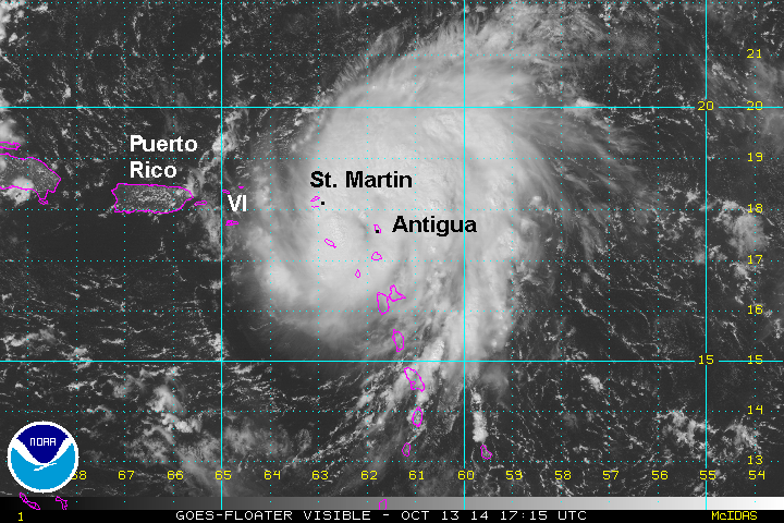
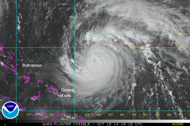
The Weather Situation:
Gonzalo is strengthening this morning over the Leewards. The center of the storm is near Antigua. Winds at V.C. Bird International airport (Antigua) were steady at 45 mph at 7 am. Steady rain was also reported. Juliana airport on St. Maarten had rain showers with a steady wind of 26 mph at 7 am.
Current Weather:
As of 8 AM EDT / 8 AM AST Tropical storm Gonzalo was centered at 17.0 N / 61.5 W or about 20 miles ESE of Antigua. It was moving west at about 10 mph. Top sustained winds are estimated at 60 mph. Pressure was estimated at 993 mb.
Tropical Weather Forecast:
Tropical storm Gonzalo's path has shifted slightly north. This will spare Puerto Rico from the worst effects. It is expected to move back into the Atlantic north of the Virgin Islands Tuesday morning. It will then be east of the Turks and Caicos / Bahamas Wednesday and Thursday before it recurves northeast ahead of a cold front. It is projected in the vicinity of Bermuda by next weekend. Keep in mind that a small change in the track could take it 200-300 miles away from Bermuda. Interests in Bermuda should follow Gonzalo closely.
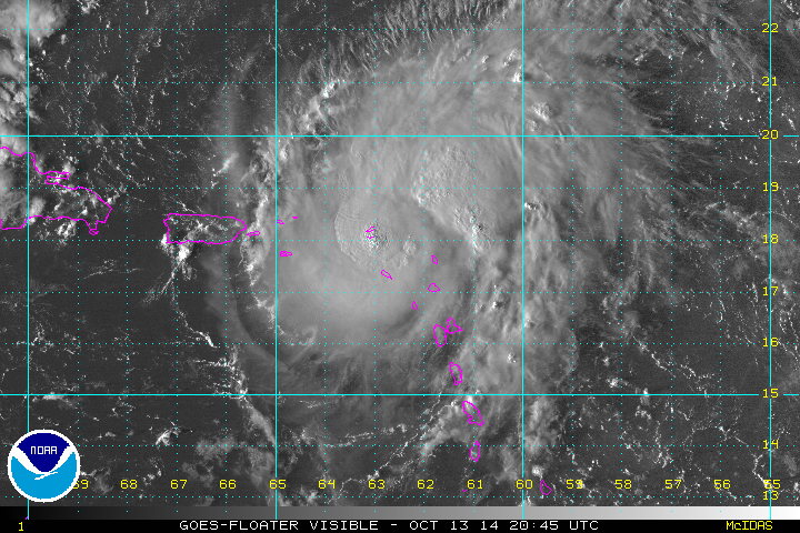
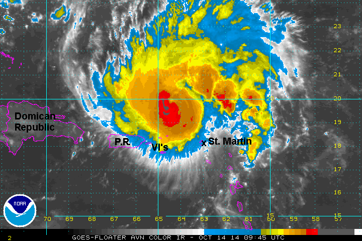
The Weather Situation:
This morning between 8-9 AM local time, Gonzalo moved over Antigua. Winds to 67 mph with gusts to 87 mph were reported. Gonzalo will move very close to St. Martin later today. The strongest winds are confined to a small area near the core of the storm.
Current Weather:
As of 2 PM EDT / 2 PM AST Tropical storm Gonzalo was centered at 17.4 N / 62.4 W or about 65 miles SE of St. Martin. It was moving WNW at about 10 mph. Top sustained winds are estimated at 70 mph. Pressure was estimated at 988 mb.
Tropical Weather Forecast:
Gonzalo will move back into the Atlantic north of the Virgin Islands Tuesday morning. It will then be east of the Turks and Caicos / Bahamas Wednesday and Thursday before it recurves northeast ahead of a cold front. It is projected in the vicinity of Bermuda by next weekend. Keep in mind that a small change in the track could take it 200-300 miles away from Bermuda. Interests in Bermuda should follow Gonzalo closely.
The Weather Situation:
Gonzalo is now a hurricane. The strongest winds are in a small area near the center of the low. Reports from St. Martin have been in the vicinity of 40 mph with stronger gusts. Stronger winds are likely near St. Martin and over the higher terrain.
Current Weather:
As of 7 PM EDT / 7 PM AST Hurricane Gonzalo was centered at 18.0 N / 63.1 W or near St. Martin. It was moving NW at about 12 mph. Top sustained winds are estimated at 75 mph. Pressure was estimated at 983 mb.
Tropical Weather Forecast:
Gonzalo will move back into the Atlantic north of the Virgin Islands late tonight or Tuesday morning. It will then move east of the Turks and Caicos / Bahamas Wednesday and Thursday before it recurves northeast ahead of a cold front. It is projected in the vicinity of Bermuda by around Friday. It will rapidly move north to near eastern Newfoundland by the weekend. Keep in mind that a small change in the track could take it 200-300 miles away from Bermuda. Interests in Bermuda should follow Gonzalo closely.
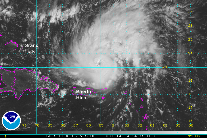
Tropicast: Atlantic Visible floater satellite - late afternoon
Gonzalo is near Anguilla. This path is a little north of the official hurricane center forecast. This means the brunt of this hurricane will miss Puerto Rico and the Virgin Islands. The center passed over St. Martin. The airport reported steady winds at 40 mph with a gust to 64 mph. I suspect that locations on the higher terrain had winds that were considerably higher.
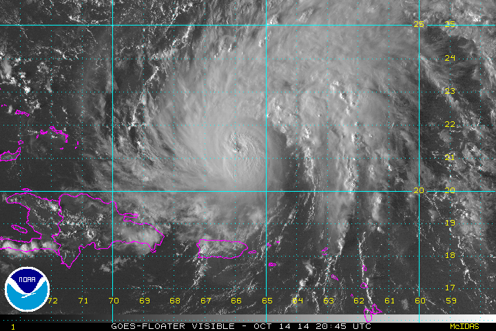
The Weather Situation:
Gonzalo continues to strengthen as is moves away from the Caribbean. Puerto Rico and the Virgin Islands saw minimal effects from the hurricane. The Leeward Islands of Anguilla, St. Martin saw the strongest effects with tropical storm force winds and some gusts to hurricane force, especially over the higher terrain. Reports were sparse as official reporting stations closed before the the strongest part of the hurricane hit. Better estimates will be realized today as weather improves.
Current Weather:
As of 6 AM EDT / 6 AM AST Hurricane Gonzalo was centered at 19.8 N / 64.5 W or about 110 miles NNE of St. Thomas. It was moving NW at about 13 mph. Top sustained winds are estimated at 110 mph. Pressure was estimated at 974 mb.
Tropical Weather Forecast:
Gonzalo will be moving east of the Turks and Caicos / Bahamas Wednesday and Thursday before it recurves northeast ahead of a cold front. It is projected in the vicinity of Bermuda by around Friday. It will rapidly move north to near eastern Canada by the end of the weekend. Keep in mind that a small change in the track could take it 200-300 miles away from Bermuda. Interests in Bermuda should follow Gonzalo closely.
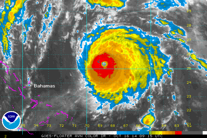
The Weather Situation:
The eye on Gonzalo is now becoming visible as wind shear lessens. This may be a signal of weaker wind shear and the start of a rapid deepening phase. High surf will be the primary effect on the Turks and Caicos and Bahamas the next few days. An outer rain band may affect the eastern part of the region, but should not be that much of a concern.
Current Weather:
As of 11 AM EDT / 11 AM AST Hurricane Gonzalo was centered at 20.3 N / 65.2 W or about 390 miles ESE of Grand Turk / 870 south of Bermuda. It was moving NW at about 13 mph. Top sustained winds are estimated at 110 mph. Pressure was estimated at 973 mb.
Tropical Weather Forecast:
Gonzalo will be moving east of the Turks and Caicos / Bahamas through Thursday before it recurves northeast ahead of a cold front. It is projected in the vicinity of Bermuda by around Friday. It will rapidly move north to near eastern Canada by the end of the weekend. Keep in mind that a small change in the track could take it 200-300 miles away from Bermuda. Interests in Bermuda should follow Gonzalo closely.
The Weather Situation:
Continued strengthening has occurred this afternoon. Gonzalo is now a major hurricane. Currently it is not affecting land. A NOAA buoy 55 miles to the ESE of the center reported seas to 20 feet. Seas will continue to build as Gonzalo strengthens.
Current Weather:
As of 5 PM EDT / 5 PM AST Hurricane Gonzalo was centered at 21.2 N / 66.0 W or about 330 miles east of Grand Turk / 770 south of Bermuda. It was moving NW at about 13 mph. Top sustained winds are estimated at 115 mph. Pressure was estimated at 970 mb.
Tropical Weather Forecast:
Gonzalo will be moving east of the Turks and Caicos / Bahamas through Thursday before it recurves northeast ahead of a cold front. It is projected in the vicinity of Bermuda by around Friday. It will rapidly move north to near eastern Canada by the end of the weekend. Keep in mind that a small change in the track could take it 200-300 miles away from Bermuda. Interests in Bermuda should follow Gonzalo closely.
The Weather Situation:
Gonzalo strengthened slightly earlier today allowing it to be classified as a category four hurricane. Overall, the appearance has not changed very much with some dry air to the northwest of the hurricane. Earlier today a buoy close the the center reported a gust to 74 mph with 32.5 foot seas. I was actually expecting to see more extreme conditions if this hurricane is really at 125 mph (strong category 3). We also should be finding gusts to about 150 mph. I will be watching the latest recon flight to see if it confirms this type of strength.
Current Weather:
As of 5 PM EDT / 5 PM AST Hurricane Gonzalo was centered at 24.1 N / 68.6 W or 590 miles SSW of Bermuda. It was moving NW at about 10 mph. Top sustained winds are estimated at 125 mph (NHC). Pressure was estimated at 953 mb.
Tropical Weather Forecast:
Gonzalo's forecast remains nearly unchanged. It will stay east of the Bahamas today and early tomorrow then turn more NNE. This will take it close to Bermuda Friday. Some effects will be seen Thursday night. It will rapidly accelerate and be near Newfoundland Saturday night. Interests in Bermuda and Newfoundland should follow Gonzalo closely.
The Weather Situation:
Gonzalo become a category four hurricane again overnight. The appearance on satellite now is much more impressive than any other time during its life cycle. An eyewall replacement cycle appears to be finished which has allowed strengthening. The hurricane center's official forecast calls for continued weakening. IMO, it is still possible for some additional strengthening before this weakening trend takes over.
There are no buoys near Gonzalo at this time so no actual seas reports can be obtained. Wave models show seas build to about 35 feet near Bermuda and over 40 feet once Gonzalo is off of the Northeast U.S. coast headed toward eastern Newfoundland. A new recon plane will be over the hurricane in about an hour.
Current Weather:
As of 5 AM EDT / 5 AM AST Hurricane Gonzalo was centered at 25.3 N / 68.7 W or 540 miles SSW of Bermuda. It was moving north at about 9 mph. Top sustained winds are estimated at 140 mph. Pressure was estimated at 945 mb.
Tropical Weather Forecast:
Gonzalo has started to turn and will be very close to Bermuda Friday. Some effects will be seen starting tonight. It will rapidly accelerate and be near Newfoundland Saturday night. Interests in Bermuda and Newfoundland should follow Gonzalo closely.