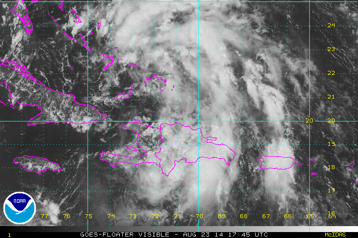
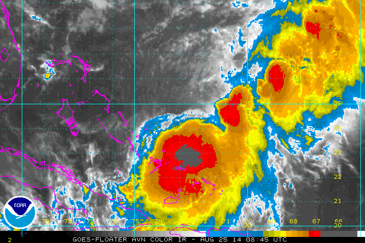
Showers and storms associated with 96L are expanding toward the central and northern Bahamas. The center of circulation is now centered between the Turks and Caicos and SE Bahamas. When classified, 96L will be named Christobal.
Forecast:
96L will likely be upgraded to a tropical depression or storm during the next 24 hours. It will slowly move across the Bahamas bringing breezy conditions with heavy showers and storms. Forecast models have been erratic on its motion and still can not be trusted until an actual low pressure center develops. Models now take this system toward SE Florida then northward just east of the peninsula. Buy Friday the system is east of North Carolina.
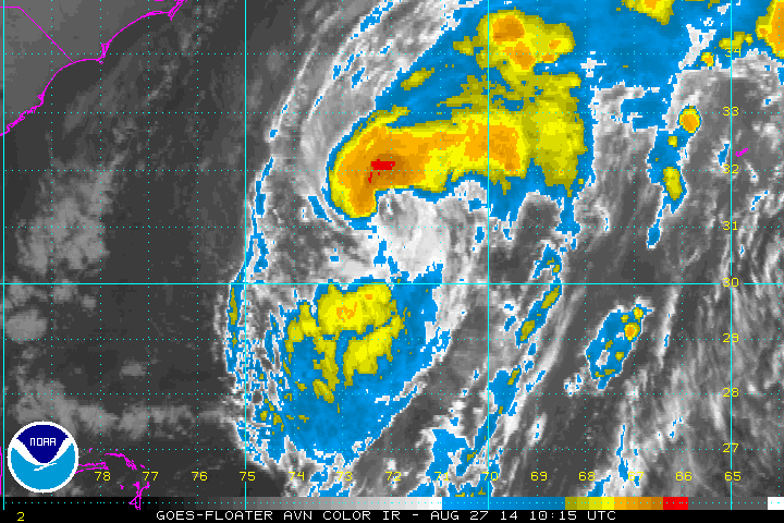
The hurricane center upgraded the disturbance to tropical depression status this evening. It is still very disorganized but conditions favor strengthening. The heaviest showers and storms remain on the eastern side of the circulation east of the Bahamas. Additional rainbands are over Puerto Rico and Hispaniola to the south.
As of 8 pm EDT tropical depression 4 was centered at 22.0 N / 72.3 W or about 80 miles NE of Great Inagua, Bahamas. It was moving NW at about 11 mph. Top sustained winds estimated at 35. Pressure was estimated at 1005 mb.
Forecast:
The most recent model runs show the tropical cyclone drifting NW through the Bahamas into Tuesday and east of east central Florida Wednesday. It then is forecast to turn more north then northeast Thursday and Friday well east of the Southeast coast. This system has a good chance of developing into a hurricane.
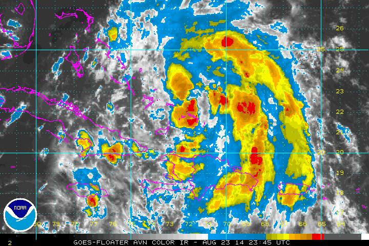
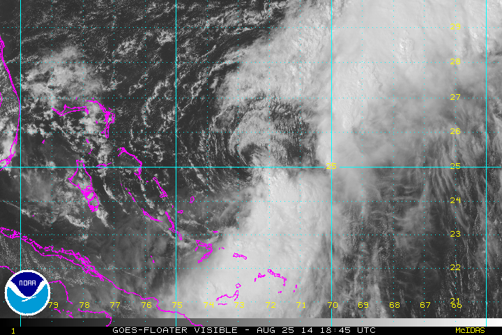
Christobal's center was relocated farther NE by the hurricane hunters this morning. It appears that the effects of this tropical storm will mainly affect the SE Bahamas / Turks and Caicos today and tomorrow and then diminish.
As of 8 am EDT Christobal was centered at 23.0 N / 73.0 W or about 135 miles ESE of Long Island, Bahamas. It was moving NW at about 9 mph. Top sustained winds estimated at 40. Pressure was estimated at 1001 mb.
Forecast:
The most recent model runs show Christobal to move more northeast away from land. It will pull away from the Bahamas tomorrow and possibly affect Bermuda Thursday night. This system has a good chance of developing into a hurricane.
Christobal is still not well organized as it's mid level and low level circulations have been displaced. As a main central circulation is trying to develop, this center is now becoming established well east of the Bahamas. This means that mainly the SE Bahamas / Turks and Caicos will see the effects of heavy rainfall and breezy conditions. Rainfall amounts could top 10 inches in those area. The rest of the Bahamas may escape most of the unsettled weather.
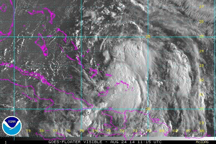
As of 5 pm EDT Christobal was centered at 24.5 N / 73.0 W or about 155 miles ENE of Long Island, Bahamas. It was moving north at about 8 mph. Top sustained winds are estimated at 45. Pressure was estimated at 1001 mb.
Forecast:
The most recent model runs show Christobal to move more northeast away from land. It is now pulling east away from the Bahamas and heavy showers will diminish tonight and tomorrow. The center is expect to pass well west of Bermuda Thursday. This system has a good chance of developing into a hurricane.
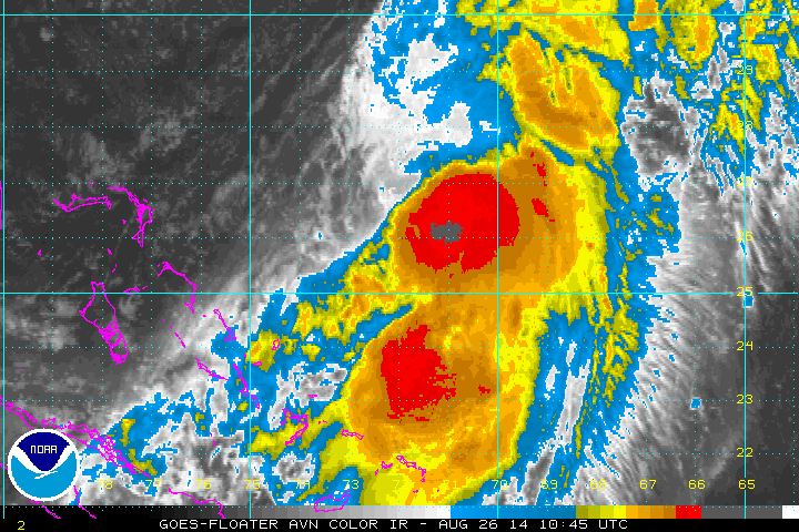
Christobal continues to bring heavy rainfall to the SE Bahamas and Turks and Caicos. Rainfall amounts may be in excess of 10 inches. Wind shear is keeping the heavy rainfall to the south and southeast side of the circulation. Because of this, much of the central and northern Bahamas are being spared most of the effects from the storm.
As of 5 am EDT Christobal was centered at 24.5 N / 72.8 W or about 110 miles ENE of San Salvador, Bahamas / 725 miles SW of Bermuda. It was moving north at about 3 mph. Top sustained winds are estimated at 50. Pressure was estimated at 994 mb.
Forecast:
Christobal is expected to move north, then northeast away from land. It is now slowly pulling away from the Bahamas and heavy showers will slowly diminish. The center is expect to pass well west of Bermuda Thursday. Bermuda will still likely see some effects. This system has a good chance of developing into a hurricane.
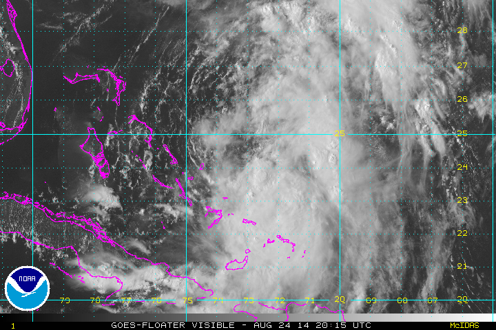
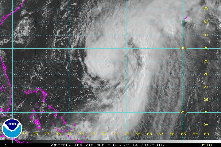
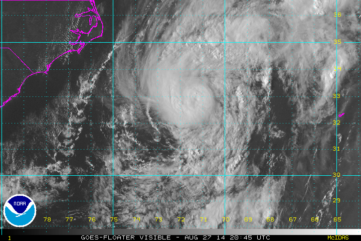
Christobal is still badly sheared. Heavy rainfall continues over the SE Bahamas and Turks and Caicos. The rest of the Bahama Islands are experiencing nice weather. Weather will improve in the Bahamas as Christobal accelerates away tomorrow.
As of 2 pm EDT Christobal was centered at 24.6 N / 72.7 W or about 120 miles ENE of San Salvador, Bahamas / 715 miles SW of Bermuda. It was moving NNE at about 3 mph. Top sustained winds are estimated at 60. Pressure was estimated at 993 mb.
Forecast:
Christobal is expected to move north, then northeast away from land. It is now slowly pulling away from the Bahamas and heavy showers will slowly diminish. The center is expect to pass well west of Bermuda Wednesday night. Bermuda will still likely see some effects. This system has a good chance of developing into a hurricane.
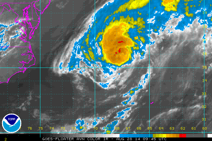
Christobal Is slowly strengthening as wind shear relaxes. It is now pulling away from the SE Bahamas and Turks and Caicos. Additional rainfall of 2-4" is possible, but will taper down later today. Rainfall will increase across Bermuda during the next 24 hours. Even though the hurricane is expected to pass west of Bermuda tomorrow, it will be close enough to produce winds to tropical storm force.
From my estimation Christobal is not quite a hurricane. Recon reported surface winds between 65-70 mph and flight level winds to 75 mph. Minimal hurricane strength is 74 mph sustained winds at the surface.
As of 5 am EDT Christobal was centered at 26.0 N / 71.9 W or about 610 miles SW of Bermuda. It was moving north at about 12 mph. Top sustained winds are estimated at 70 (NHC 75 mph). Pressure was estimated at 987 mb.
Forecast:
Christobal is expected to turn more NNE and pass well west of Bermuda Wednesday . Bermuda will still likely see some effects. Tropical storm force winds, heavy showers and high surf are likely.
IMO Christobal is still not a hurricane, but is getting very close. A surface wind estimate from the hurricane hunter was almost 70 mph, so that is my unofficial estimate. Pressure is also slowly dropping as shear continues to weaken. IMO Christobal will probably reach hurricane strength later this evening.
As of 5 pm EDT Christobal was centered at 28.8 N / 71.4 W or about 460 miles SW of Bermuda. It was moving north at about 16 mph. Top sustained winds are estimated at 70 (NHC 75 mph). Pressure was estimated at 984 mb.
Forecast:
Christobal is expected to turn more NNE and pass well west of Bermuda Wednesday. Bermuda will still likely see some effects. Tropical storm force winds, heavy showers and high surf are likely.
Christobal is passing west of Bermuda. There will be some effects from the hurricane. The effects include winds to minimal tropical storm force - 40-45 mph / scattered showers and storms / high swell. Satellite imagery shows that the eyewall is strongest on the NW side, but is broken on the SE side. Recon did not find much change in wind speed from yesterday evening. Christobal remains a minimal hurricane.
As of 8 am EDT Christobal was centered at 31.5 N / 72.0 W or about 425 miles west of Bermuda. It was moving north at about 12 mph. Top sustained winds are estimated at 80 mph. Pressure was estimated at 983 mb.
Forecast:
Christobal will pass well west of Bermuda today. It will turn NE Thursday and pass several hundred miles south of Nova Scotia Canada then continue into the far north Atlantic.
Christobal is almost half way between the Outer Banks and Bermuda. It has changed very little in structure today. Bermuda has actually had a nice day with little rainfall. Winds have been out of the south at 20 mph. Large swell has been the main impact.
As of 5 pm EDT Christobal was centered at 32.7 N / 71.4 W or about 385 miles west of Bermuda. It was moving north at about 15 mph. Top sustained winds are estimated at 75 mph. Pressure was estimated at 984 mb.
Forecast:
Christobal is moving NNE and will be well NW of Bermuda tonight. It will turn NE Thursday and pass several hundred miles south of Nova Scotia, Canada then continue into the far north Atlantic.
Christobal is now accelerating and has doubled its forward speed since last evening. The structure is still quite similar to the past 48 hours. It will be moving over colder water and gradually lose its tropical characteristics during the next 24-36 hours. High swell will be the only impacts to the U.S. east coast.
As of 5 am EDT Christobal was centered at 35.6 N / 67.8 W or about 285 miles west of Bermuda / 660 SSW of Halifax Nova Scotia, Canada. It was moving north at about 29 mph. Top sustained winds are estimated at 75 mph. Pressure was estimated at 985 mb.
Forecast:
Christobal is moving NE and is well NNW of Bermuda this morning. It will be is passing several hundred miles south of Nova Scotia, Canada later today then continue into the far north Atlantic as an extratropical cyclone toward Iceland.