Arthur
Moderator: Florida Beach Gal
- Tropical Inspector
- Site Admin
- Posts: 3697
- Joined: Tue Feb 20, 2007 2:28 pm
- Antispam: no
- Location: Under a palm tree
- Contact:
Arthur
Tuesday Midday Update
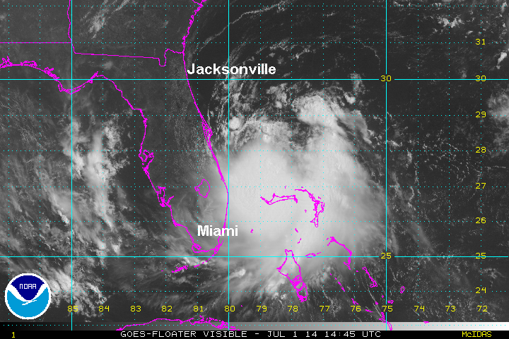
Arthur classified east of Florida
Sustained winds from Grand Bahama Island of 38 mph earlier this morning convinced the hurricane center to upgrade from tropical depression strength to tropical storm (sustained winds of 39 mph).
Arthur continues to fight northerly wind shear, although deep convection is now expanding south of the center. Warm sea surface temperatures should aid in development. Upper air winds will strengthen by later Thursday and Friday which will not only accelerate Arthur, but increase wind shear again. Strengthening to a hurricane will have to occur in the window of opportunity during the next two days when upper air winds will be lighter.
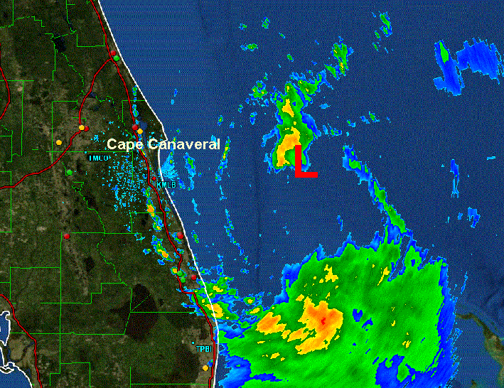
As of 11 am edt Arthur was centered at 27.6 N / 79.3 W or about 95 southeast of Cape Canaveral, FL. Officially it was moving nw at about 2 mph. Top sustained winds estimated at 40 mph ( 40 mph NHC advisory). Pressure was estimated at 1007 mb. Latest radar imagery show more of a westerly jog closer to the east central Florida coast.
Forecast:
Aurthur is expected to slowly strengthen the next few days. It is drifting nw which could take it close the the northeast Florida coast by late tonight / Wednesday. After Wednesday upper air winds should start accelerating Arthur more northward then nne. This will take it close to the Outer Banks Friday morning then offshore of the Mid-Atlantic and New England coast late Friday and early Saturday.
Tropicast: Atlantic visible floater satellite
Tropicast: Florida Radar
Rich Johnson
Twitter: https://twitter.com/richjohnsonwx
Certified Broadcast Meteorologist - Hurricane Expert
Twitter: https://twitter.com/richjohnsonwx
Certified Broadcast Meteorologist - Hurricane Expert
- Tropical Inspector
- Site Admin
- Posts: 3697
- Joined: Tue Feb 20, 2007 2:28 pm
- Antispam: no
- Location: Under a palm tree
- Contact:
Re: Arthur
Tuesday Evening Update
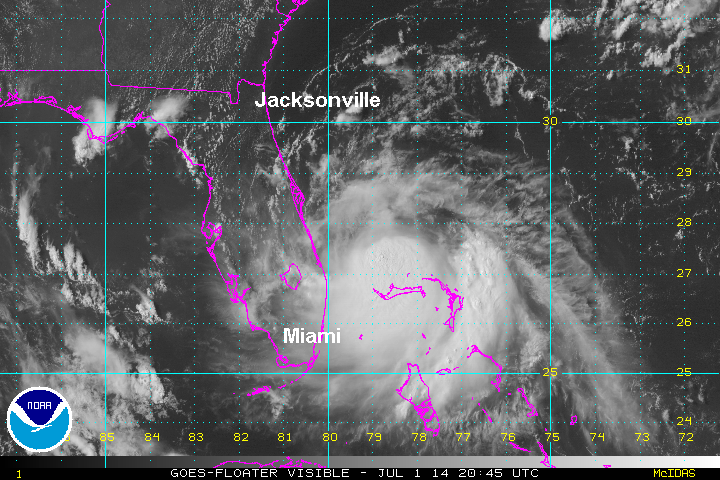
Arthur slightly strengthens
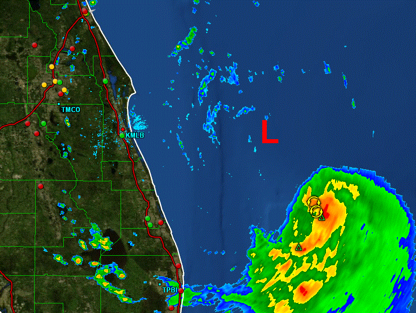
Radar this afternoon has shown that Arthur's center of circulation continues to have little convection Satellite imagery also shows dry air residing north of the system over north Florida. The strengthening has been the result of expanding deep convection south of the center near the Bahamas.
As of 5 pm edt Arthur was centered at 27.8 N / 79.4 W or about 85 east southeast of Cape Canaveral, FL. It was moving NW at about 2 mph. Top sustained winds estimated at 50 mph (50 mph NHC advisory). Pressure was estimated at 1003 mb.
Forecast:
Aurthur is expected to slowly strengthen the next few days. It is drifting NW which could take it close the the northeast Florida coast by late tonight / Wednesday. After Wednesday upper air winds should start accelerating Arthur more northward then NNE. This will take it close to the Outer Banks Friday morning then offshore of the Mid-Atlantic and New England coast late Friday and early Saturday.
Tropicast: Atlantic visible floater satellite
Tropicast: Florida Radar
Rich Johnson
Twitter: https://twitter.com/richjohnsonwx
Certified Broadcast Meteorologist - Hurricane Expert
Twitter: https://twitter.com/richjohnsonwx
Certified Broadcast Meteorologist - Hurricane Expert
- Tropical Inspector
- Site Admin
- Posts: 3697
- Joined: Tue Feb 20, 2007 2:28 pm
- Antispam: no
- Location: Under a palm tree
- Contact:
Re: Arthur
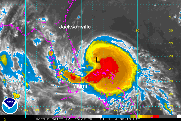
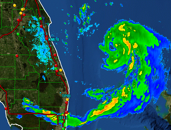
Tuesday Late Evening Update
Arthur becoming better organized this evening
Radar has showed deep convection building around the center of circulation. This will allow for further strengthening.
As of 11 pm edt Arthur was centered at 27.9 N / 79.2 W or about 90 miles east southeast of Cape Canaveral, FL. It was moving north at about 2 mph. Top sustained winds estimated at 50 mph (50 mph NHC advisory). Pressure was estimated at 1003 mb.
Forecast:
Aurthur is expected to continue strengthening the next few days to possibly a minimal hurricane. It has started moving in a more northerly direction. Upper air winds should start accelerating Arthur Thursday moving it more to the NNE. This will take it close to the coast of eastern North Carolina Thursday night into Friday morning, then offshore of the Mid-Atlantic and New England coast late Friday and early Saturday.
Tropicast: Atlantic IR floater satellite
Tropicast: Florida Radar
Rich Johnson
Twitter: https://twitter.com/richjohnsonwx
Certified Broadcast Meteorologist - Hurricane Expert
Twitter: https://twitter.com/richjohnsonwx
Certified Broadcast Meteorologist - Hurricane Expert
- Tropical Inspector
- Site Admin
- Posts: 3697
- Joined: Tue Feb 20, 2007 2:28 pm
- Antispam: no
- Location: Under a palm tree
- Contact:
Re: Arthur
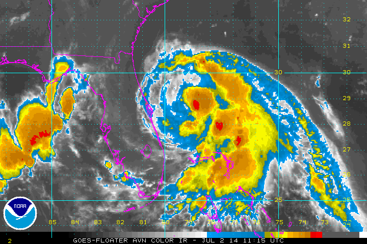
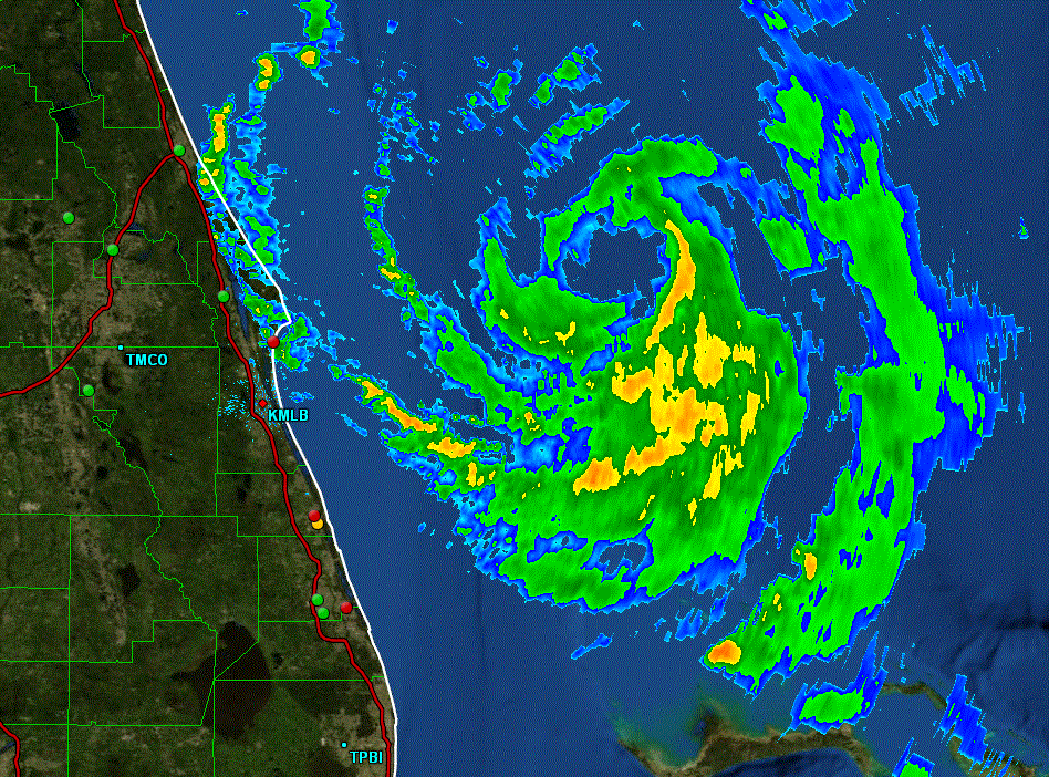
Wednesday Morning Update
Arthur east of Cape Canaveral
Radar continues to show increased organized of Arthur. Heavy showers and squalls remain on the east side of the circulation well offshore. Only a few small rain bands are on the coast over east central Florida. Pressure has leveled off so last night's strengthening has taken a pause. Dry air north of Arthur yesterday was ingested into the circulation disrupting it somewhat.
As of 8 am edt Arthur was centered at 28.8 N / 79.0 W or about 100 miles east northeast of Cape Canaveral, FL / 275 miles south of Charleston, SC. It was moving north at about 6 mph. Top sustained winds estimated at 60 mph. Pressure was estimated at 998 MB.
Forecast:
Arthur will move northward toward the coast of South Carolina and be offshore south of Charleston by Thursday morning. It should then recurve more NNE taking it near the coast of eastern North Carolina Thursday night. Friday morning it will be near or just east of the Virginia Capes and accelerate to Nova Scotia, Canada by Saturday morning.
Aurthur will slowly strengthen and will likely reach minimal hurricane strength during the next 24 hours. Upper air winds will strengthen as Arthur approaches the Southeast coast. This will likely weaken Arthur some. A transition to an extratropical cyclone will occur as it approaches Canada.
Tropicast: Atlantic IR floater satellite
Tropicast: Florida Radar
Rich Johnson
Twitter: https://twitter.com/richjohnsonwx
Certified Broadcast Meteorologist - Hurricane Expert
Twitter: https://twitter.com/richjohnsonwx
Certified Broadcast Meteorologist - Hurricane Expert
- Tropical Inspector
- Site Admin
- Posts: 3697
- Joined: Tue Feb 20, 2007 2:28 pm
- Antispam: no
- Location: Under a palm tree
- Contact:
Re: Arthur
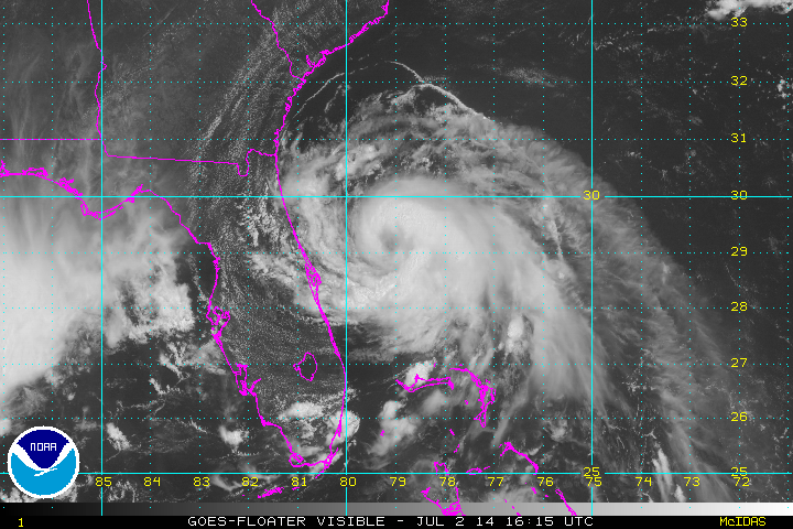
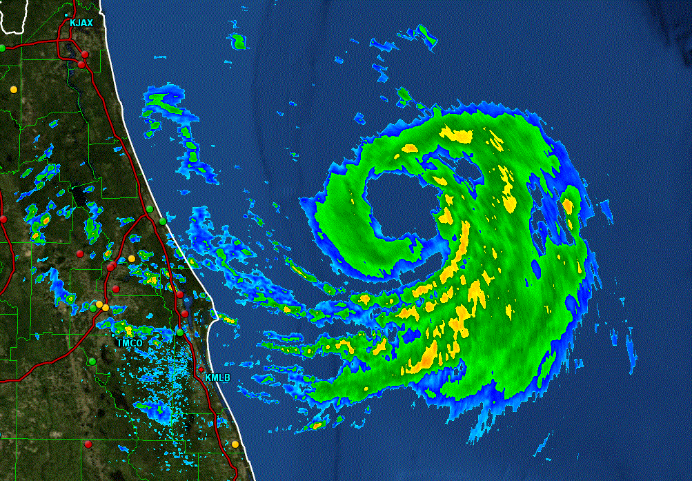
Wednesday afternoon Update
Arthur continues to organize
Visible satellite imagery shows an eye like structure starting to develop indicating that Arthur's structure is improving. Some dry air remains north and west of the system which will keep development slow and steady.
As of 1 pm edt Arthur was centered at 29.3 N / 79.2 W or about 115 miles east northeast of Cape Canaveral, FL / 250 miles south of Charleston, SC. It was moving north at about 7 mph. Top sustained winds estimated at 65 mph. Pressure was estimated at 997 MB.
Forecast:
Arthur will move northward toward the coast of South Carolina and be offshore south of Charleston by Thursday morning. It should then recurve more NNE taking it near the coast of eastern North Carolina Thursday night. Friday morning it will be near or just east of the Virginia Capes and accelerate to Nova Scotia, Canada by Saturday morning.
Aurthur will slowly strengthen and will likely reach minimal hurricane strength during the next 18 hours. Upper air winds will strengthen as Arthur approaches the Southeast coast. This will likely weaken Arthur some. A transition to an extratropical cyclone will occur as it approaches Canada.
Tropicast: Atlantic Visible floater satellite
Tropicast: Florida Radar
Rich Johnson
Twitter: https://twitter.com/richjohnsonwx
Certified Broadcast Meteorologist - Hurricane Expert
Twitter: https://twitter.com/richjohnsonwx
Certified Broadcast Meteorologist - Hurricane Expert
- Tropical Inspector
- Site Admin
- Posts: 3697
- Joined: Tue Feb 20, 2007 2:28 pm
- Antispam: no
- Location: Under a palm tree
- Contact:
Re: Arthur
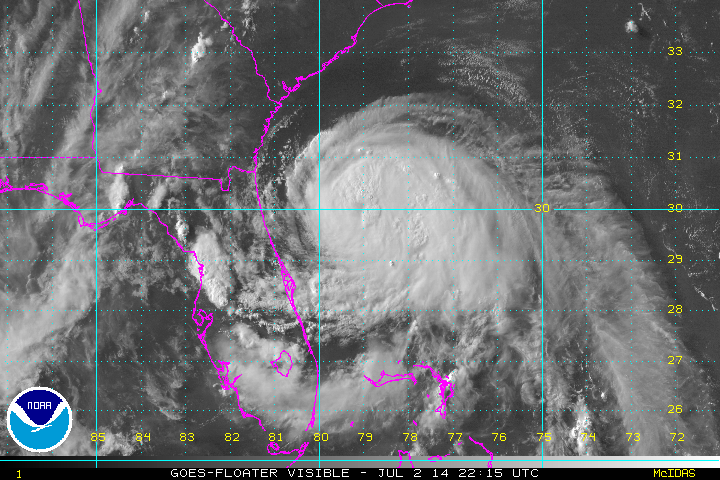
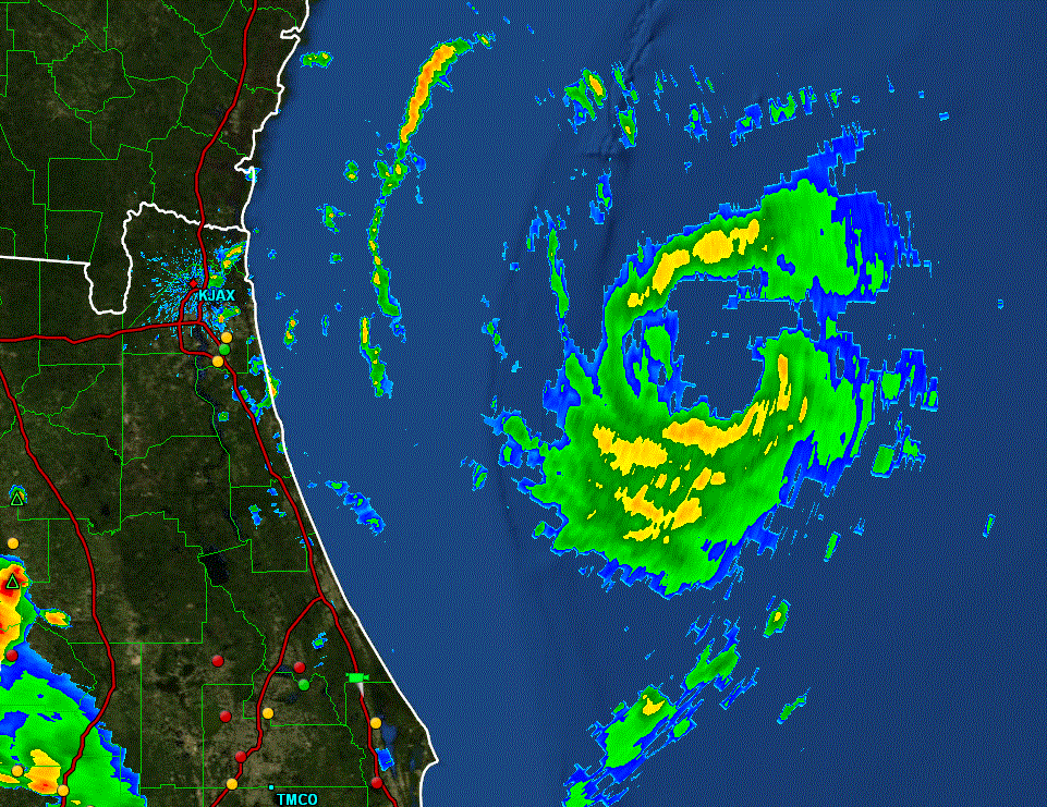
Wednesday Evening Update
Arthur still just under hurricane strength
The eye like structure that was visible earlier today has disappeared. Hurricane Hunters have been investigating today and have found the pressure dropping somewhat. Dry air north of Arthur has kept the development at a modest pace.
Buoy data showed seas near 12 feet south of the circulation earlier today. Wave forecast models build seas to 20-25 feet offshore of North Carolina and the Mid-Atlantic coast late Thursday into Friday.
As of 8 pm edt Arthur was centered at 30.2 N / 79.2 W or 180 miles SSE of Charleston, SC or 405 miles SSW of Cape Hatteras, NC. It was moving north at about 8 mph. Top sustained winds estimated at 70 mph. Pressure was estimated at 990 MB.
Forecast:
Arthur will continue moving northward toward the coast of South Carolina and be offshore south of Charleston by Thursday morning. It should then recurve more NNE taking it near the coast of eastern North Carolina Thursday night. Friday morning it will be near or just east of the Virginia Capes and accelerate to Nova Scotia, Canada by Saturday morning.
Aurthur will slowly strengthen and will likely reach minimal hurricane strength during the next six hours. Upper air winds will strengthen as Arthur approaches the Southeast coast. Winds plus the close proximity to land will likely weaken Arthur some. A transition to an extratropical cyclone will occur as it approaches Canada.
Tropicast: Atlantic Visible floater satellite
Tropicast: Florida Radar
Rich Johnson
Twitter: https://twitter.com/richjohnsonwx
Certified Broadcast Meteorologist - Hurricane Expert
Twitter: https://twitter.com/richjohnsonwx
Certified Broadcast Meteorologist - Hurricane Expert
- Tropical Inspector
- Site Admin
- Posts: 3697
- Joined: Tue Feb 20, 2007 2:28 pm
- Antispam: no
- Location: Under a palm tree
- Contact:
Re: Arthur
Arthur holding at 70 mph at 11pm edt. This is no surprise as a wall of dry air is evident to the north and northwest of the circulation. This is inhibiting development in that sector. Arthur could even weaken if any of this dry air gets ingested into the central circulation. For now, Arthur is still expected to become a minimal hurricane sometime Thursday, but we'll be watching the dry air closely.
Rich Johnson
Twitter: https://twitter.com/richjohnsonwx
Certified Broadcast Meteorologist - Hurricane Expert
Twitter: https://twitter.com/richjohnsonwx
Certified Broadcast Meteorologist - Hurricane Expert
- Tropical Inspector
- Site Admin
- Posts: 3697
- Joined: Tue Feb 20, 2007 2:28 pm
- Antispam: no
- Location: Under a palm tree
- Contact:
Re: Arthur
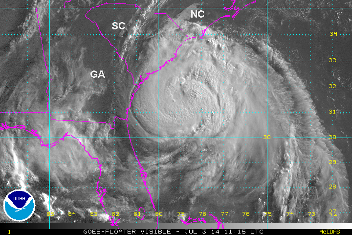
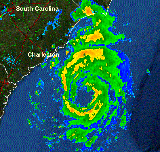
Thursday Morning Update
Arthur becomes hurricane
Slight strengthening occurred overnight to bring Arthur up to hurricane strength. Pressure has slowly dropped and the radar representation of the circulation improved the last several hours. Arthur will have a window of about 12 hours to strengthen a little more before facing strong winds aloft and interacting with land. Both of those features will weaken Arthur some. Storm tides will be 2-4 feet above normal on the North Carolina coast when coinciding with high tides.
Buoy data showed seas near 14 feet 40 miles southeast of Charleston. Wave forecast models build seas to 20-25 feet offshore of North Carolina and the Mid-Atlantic coast late today into Friday.
As of 8 am edt Arthur was centered at 31.8 N / 78.7 W or 150 miles SSW of Cape Fear, NC or 300 miles SW of Cape Hatteras, NC. It was moving NNE at about 9 mph. Top sustained winds estimated at 80 mph. Pressure was estimated at 983 MB.
Forecast:
Forecasts take Arthur near the northern South Carolina coast this afternoon and eastern North Carolina coast tonight. Friday morning it will be near or just east of the Virginia Capes and accelerate to Nova Scotia, Canada by Saturday morning.
Arthur will likely gain a little more strength today and remain a category 1 hurricane as it moves near the North Carolina coast. Upper air winds will strengthen during the next 12-24 hours. Winds plus the close proximity to land will likely weaken Arthur some. A transition to an extratropical cyclone will occur as it approaches Canada.
Tropicast: Atlantic Visible floater satellite
Tropicast: South Carolina Radar
Rich Johnson
Twitter: https://twitter.com/richjohnsonwx
Certified Broadcast Meteorologist - Hurricane Expert
Twitter: https://twitter.com/richjohnsonwx
Certified Broadcast Meteorologist - Hurricane Expert
- Tropical Inspector
- Site Admin
- Posts: 3697
- Joined: Tue Feb 20, 2007 2:28 pm
- Antispam: no
- Location: Under a palm tree
- Contact:
Re: Arthur
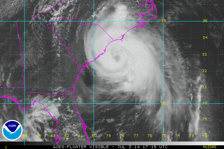
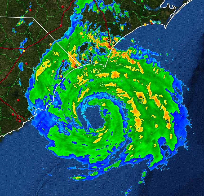
Thursday Afternoon Update
Arthur heading toward Outer Banks
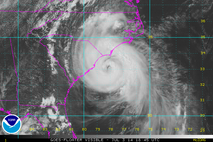
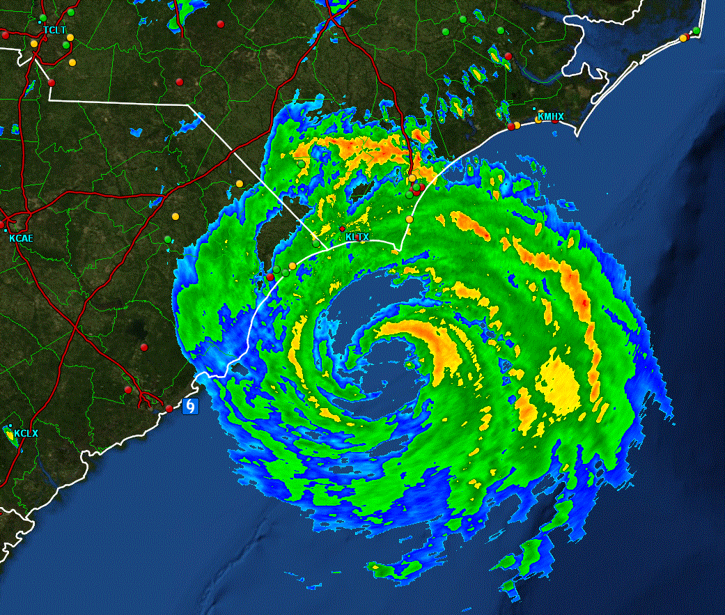
Arthur has not strengthened since late this morning. Rain bands are now affecting North Carolina near Cape fear with the eyewall offshore to the south. Charleston, SC reported a wind gust to 67 mph earlier today. Recent visible satellite imagery shows the eye becoming more pronounced again which suggests more strengthening is about to begin.
Residents of coastal North Carolina should make sure all preparations are completed soon.
Arthur will have a window of about 12 hours to strengthen a little more before facing strong winds aloft and interacting with land. Both of those features will weaken Arthur some. Storm tides will be 2-6 feet above normal on the North Carolina coast when coinciding with high tides.
Wave forecast models build seas to 20-25 feet offshore of North Carolina and the Mid-Atlantic coast late today into Friday.
As of 2 pm edt Arthur was centered at 32.9 N / 78.3 W or 70 miles SSW of Cape Fear, NC or 225 miles SW of Cape Hatteras, NC. It was moving NNE at about 13 mph. Top sustained winds estimated at 90 mph. Pressure was estimated at 980 MB.
Forecast:
Forecasts take Arthur just east of Cape Lookout late this evening and over the Outer Banks tonight. Friday morning it will be near or just east of the Virginia Capes and accelerate to Nova Scotia, Canada by Saturday morning.
Arthur has gained little more strength today and will likely be a category 2 hurricane or possibly a little stronger at landfall. Upper air winds will strengthen during the next 12-24 hours. Winds plus the close proximity to land will likely weaken Arthur some very late tonight. A transition to an extratropical cyclone will occur as it approaches Canada.
Tropicast: Atlantic Visible floater satellite
Tropicast: North Carolina Radar
Rich Johnson
Twitter: https://twitter.com/richjohnsonwx
Certified Broadcast Meteorologist - Hurricane Expert
Twitter: https://twitter.com/richjohnsonwx
Certified Broadcast Meteorologist - Hurricane Expert
- Tropical Inspector
- Site Admin
- Posts: 3697
- Joined: Tue Feb 20, 2007 2:28 pm
- Antispam: no
- Location: Under a palm tree
- Contact:
Re: Arthur
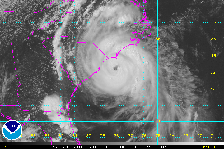
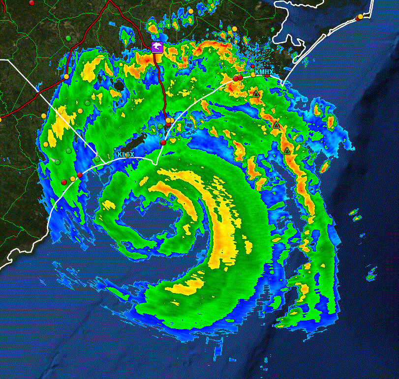
Recon from last hour showed a 977 MB pressure and 94 mph surface wind. Satellite imagery shows eye becoming better defined. This all points to increased strengthening as Arthur approaches Cape Fear (Bald Head Island) the next few hours and Cape Lookout late this evening before midnight.
Tropicast: Atlantic Visible floater satellite
Tropicast: North Carolina Radar
Tropicast: Atlantic Visible floater satellite
Tropicast: North Carolina Radar
Rich Johnson
Twitter: https://twitter.com/richjohnsonwx
Certified Broadcast Meteorologist - Hurricane Expert
Twitter: https://twitter.com/richjohnsonwx
Certified Broadcast Meteorologist - Hurricane Expert
- Tropical Inspector
- Site Admin
- Posts: 3697
- Joined: Tue Feb 20, 2007 2:28 pm
- Antispam: no
- Location: Under a palm tree
- Contact:
Re: Arthur
Thursday Evening Update
Arthur near Cape Fear
Recent satellite imagery continues to show the eye becoming more organized which suggests more strengthening is possible. Strong damaging winds and rough surf will be felt up the eastern coast of North Carolina tonight. Power outages will be widespread near the coast as winds gust over 100 mph.
Residents of coastal North Carolina should have completed all preparations.
Arthur will have a window of about 6-12 more hours to strengthen a little more before facing strong winds aloft and interacting with land. Both of those features will weaken Arthur some. Storm tides will be 2-6 feet above normal on the North Carolina coast when coinciding with high tides.
Wave forecast models build seas to 20-25 feet offshore of North Carolina and the Mid-Atlantic coast late today into Friday.
As of 5 pm edt Arthur was centered at 33.4 N / 77.9 W or 35 miles south of Cape Fear, NC / 185 miles SW of Cape Hatteras, NC. It was moving NNE at about 13 mph. Top sustained winds estimated at 90 mph. Pressure was estimated at 979 MB.
Forecast:
Forecasts take Arthur just east of Cape Lookout late this evening and over the Outer Banks tonight. Friday morning it will be near or just east of the Virginia Capes and accelerate to Nova Scotia, Canada by Saturday morning.
Arthur has gained little more strength today and will likely be a category 2 hurricane or possibly a little stronger at landfall over the Outer Banks. Upper air winds will strengthen during the next 12-24 hours. Winds plus the close proximity to land will likely weaken Arthur some very late tonight. A transition to an extratropical cyclone will occur as it approaches Canada.
Tropicast: Atlantic Visible floater satellite
Tropicast: North Carolina Radar
Rich Johnson
Twitter: https://twitter.com/richjohnsonwx
Certified Broadcast Meteorologist - Hurricane Expert
Twitter: https://twitter.com/richjohnsonwx
Certified Broadcast Meteorologist - Hurricane Expert
- Tropical Inspector
- Site Admin
- Posts: 3697
- Joined: Tue Feb 20, 2007 2:28 pm
- Antispam: no
- Location: Under a palm tree
- Contact:
Re: Arthur
Thursday Late Evening Update
Arthur heading toward Cape Lookout
Arthur is now feeling the effects of dry air that is being entrained into the circulation. Dry air is wrapping into the circulation which should soon slow or stop the strengthening that we have seen today. It is causing the eye to become more elongated. In addition, it's close proximity to land and increasing wind shear will start to weaken it soon.
I'm really not sure of why NHC upped winds to 100 mph from 90 mph. The pressure from the recon was down slightly, but not enough for a 10 mph jump IMO. A buoy reported a gust to 81 mph. Keep in mind that a 100 mph sustained wind should have gusts to 115-120 mph. I'm just not seeing gusts that high yet. Hopefully the next recon will provide additional info on this change.
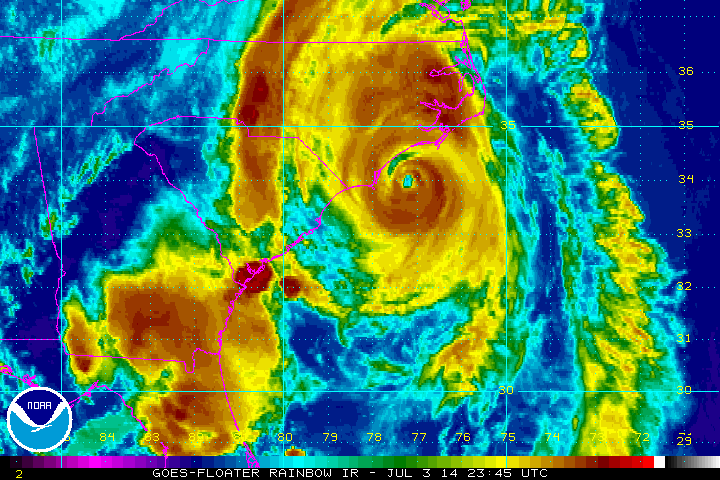
As of 9 pm edt Arthur was centered at 34.2 N / 77.1 W or 110 miles SW of Cape Hatteras, NC. It was moving NNE at about 15 mph. Top sustained winds estimated at 100 mph. Pressure was estimated at 976 MB.
Forecast:
Forecasts take Arthur over the Outer Banks tonight. Friday morning it will be near or just east of the Virginia Capes and accelerate to Nova Scotia, Canada by Saturday morning.
Tropicast: Atlantic IR floater satellite
Tropicast: North Carolina Radar
Rich Johnson
Twitter: https://twitter.com/richjohnsonwx
Certified Broadcast Meteorologist - Hurricane Expert
Twitter: https://twitter.com/richjohnsonwx
Certified Broadcast Meteorologist - Hurricane Expert
- Tropical Inspector
- Site Admin
- Posts: 3697
- Joined: Tue Feb 20, 2007 2:28 pm
- Antispam: no
- Location: Under a palm tree
- Contact:
Re: Arthur
10:30 PM EDT:
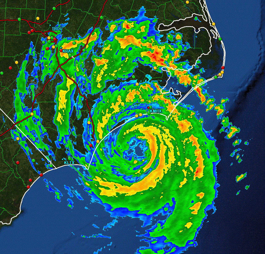
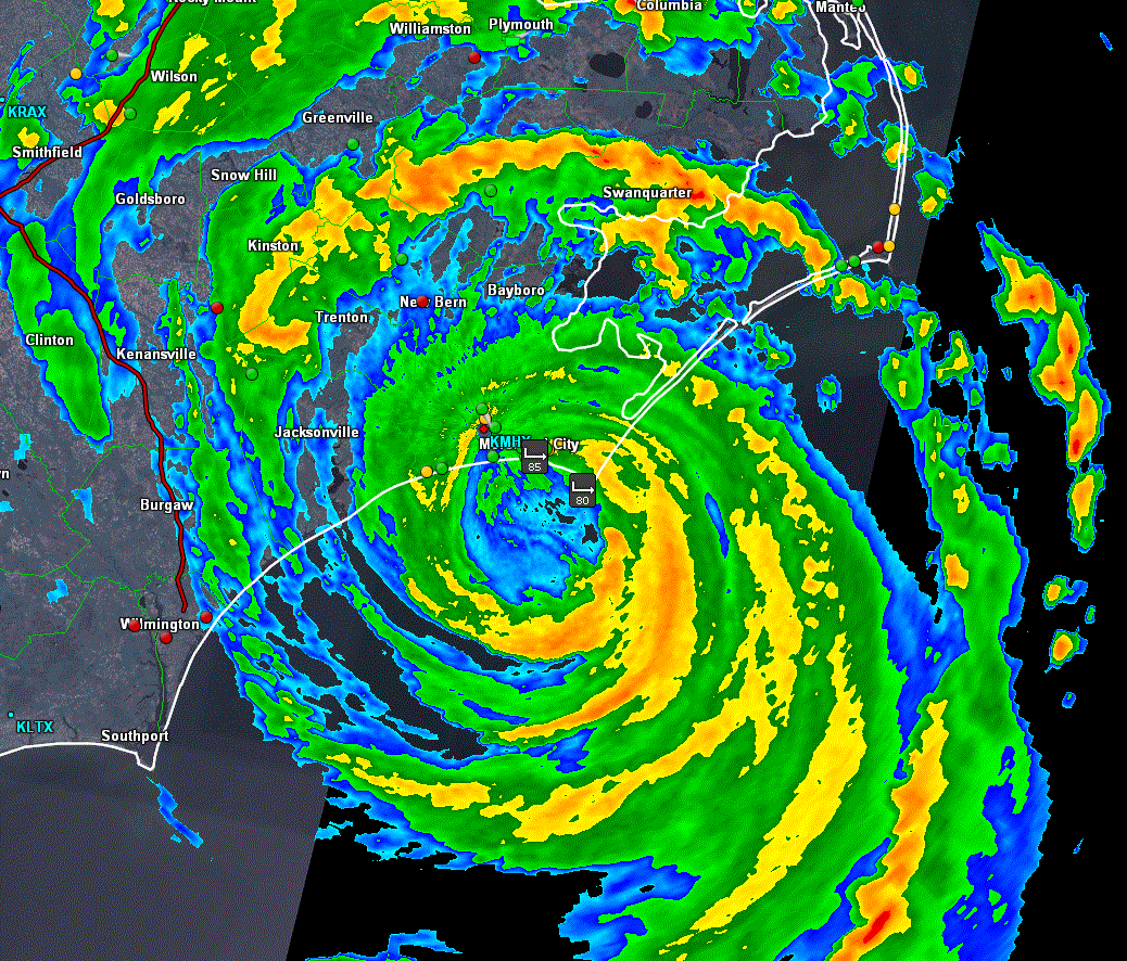
Northern eye wall from Cape Lookout west across Emerald Isle. Doppler radar indicating winds 70-85 mph. Eye will pass over Cape Lookout around midnight tonight and Cape Hatteras 3-4 am.
Strongest wind gusts at selected locations
Beaufort - 54 mph
Hatteras - 55 mph
Jacksonville - 41 mph
Wilmington 59 mph
Cape Lookout - 84 mph
Ft. Macon - 87 mph
Rich Johnson
Twitter: https://twitter.com/richjohnsonwx
Certified Broadcast Meteorologist - Hurricane Expert
Twitter: https://twitter.com/richjohnsonwx
Certified Broadcast Meteorologist - Hurricane Expert
- Tropical Inspector
- Site Admin
- Posts: 3697
- Joined: Tue Feb 20, 2007 2:28 pm
- Antispam: no
- Location: Under a palm tree
- Contact:
Re: Arthur
Eye just south of Atlantic Beach heading to Cape Lookout
Tropicast: North Carolina 10:45 pm EDT Radar
Rich Johnson
Twitter: https://twitter.com/richjohnsonwx
Certified Broadcast Meteorologist - Hurricane Expert
Twitter: https://twitter.com/richjohnsonwx
Certified Broadcast Meteorologist - Hurricane Expert
- Tropical Inspector
- Site Admin
- Posts: 3697
- Joined: Tue Feb 20, 2007 2:28 pm
- Antispam: no
- Location: Under a palm tree
- Contact:
Re: Arthur
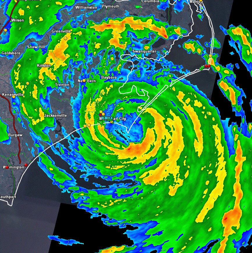
Eye directly over Cape Lookout at 11:15 PM EDT
Tropicast: North Carolina Radar
Rich Johnson
Twitter: https://twitter.com/richjohnsonwx
Certified Broadcast Meteorologist - Hurricane Expert
Twitter: https://twitter.com/richjohnsonwx
Certified Broadcast Meteorologist - Hurricane Expert
Who is online
Users browsing this forum: No registered users and 0 guests