Wednesday Night Update
Andrea classified over the eastern Gulf
As expected Andrea was classified this evening. Andrea probably isn't quite a tropical storm, but was likely named because of the impacts to Florida. This will include a storm surge of 2-4 feet from near Tampa to Apalachee Bay. Heavy rainfall over 5 inches is possible over the Florida peninsula.
I don't believe that Andrea is quite up to tropical storm strength. This is due to the fact that the strongest winds recently are 42 knots in a gust at a buoy. A tropical storm of 40 mph should have gusts near 50 mph. Anyhow, I would have made the same move as NHC and named Andrea because of the impacts.
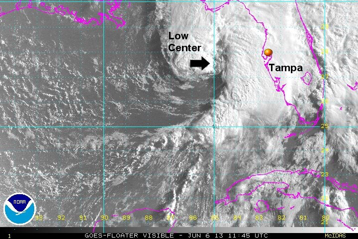
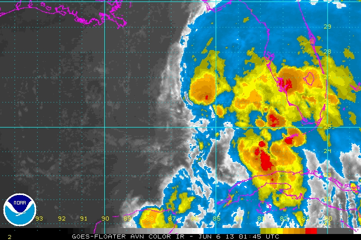
As of 11 pm edt Andrea was centered at 26.0 N / 86.3 W or about 270 wsw of Tampa, Florida. It was moving n at about 6 mph. Top sustained winds estimated at 35 mph ( 40 mph NHC advisory). Pressure was estimated at 1002 mb.
Forecast models take Andrea into the Florida coast during the day Thursday and inland up the eastern seaboard the next few days. Heavy rainfall will sweep up the eastern seaboard late Thursday through Friday.
Don't pay too much attention to the landfall time. This is a minimal tropical storm and the main effects will be well ahead of the low crossing land.
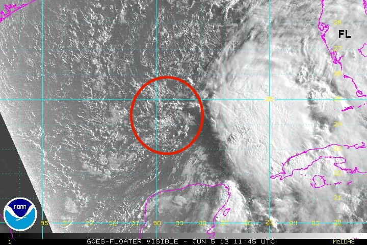
Tropicast: Visible Floater Satellite (Wed Afternoon)
Tropicast: I.R. Floater Satellite (Wed Night)
Andrea
- Tropical Inspector
- Site Admin
- Posts: 3697
- Joined: Tue Feb 20, 2007 2:28 pm
- Antispam: no
- Location: Under a palm tree
- Contact:
Andrea
Rich Johnson
Twitter: https://twitter.com/richjohnsonwx
Certified Broadcast Meteorologist - Hurricane Expert
Twitter: https://twitter.com/richjohnsonwx
Certified Broadcast Meteorologist - Hurricane Expert
- Tropical Inspector
- Site Admin
- Posts: 3697
- Joined: Tue Feb 20, 2007 2:28 pm
- Antispam: no
- Location: Under a palm tree
- Contact:
Re: Andrea
Thursday Morning Update
Andrea strengthens overnight
Andrea is more organized compared to last night. NHC raised the winds up to 60 mph based on a flight level recon wind. Andrea is looking more like a system with a strong very large bow echo on the eastern side of the circulation. Based on that fact I believe that low level sustained winds are a little lower than 60 mph and that the wind measured by the recon is more representative of a gust.
The structure is showing the low on the western side of an impressive dry slot barely under the deep convection. Because of this, I agree with NHC that no major strengthening should occur before landfall later today. Rainfall will remain the main concern with 5-10" possible north of Tampa and over 5" other areas on the peninsula. Winds will be gusty with the bow feature.
As of 8 am edt Andrea was centered at 27.7 N / 85.1 W or about 160 w of Tampa, Florida. It was moving nne at about 14 mph. Top sustained winds estimated at 55 mph (60 mph NHC advisory). Pressure was estimated at 997 mb.
Forecast models take Andrea into the Florida coast near Cedar Key later today Thursday and inland up the eastern seaboard the next few days. Heavy rainfall will sweep up the eastern seaboard Friday through Saturday morning.
Don't pay too much attention to the landfall time. This is a storm and the main effects will be ahead of the low crossing land.
Tropicast: Visible Floater Satellite
Rich Johnson
Twitter: https://twitter.com/richjohnsonwx
Certified Broadcast Meteorologist - Hurricane Expert
Twitter: https://twitter.com/richjohnsonwx
Certified Broadcast Meteorologist - Hurricane Expert
- Tropical Inspector
- Site Admin
- Posts: 3697
- Joined: Tue Feb 20, 2007 2:28 pm
- Antispam: no
- Location: Under a palm tree
- Contact:
Re: Andrea
Andrea is moving inland at this time north of Cedar Key, Florida.
Rich Johnson
Twitter: https://twitter.com/richjohnsonwx
Certified Broadcast Meteorologist - Hurricane Expert
Twitter: https://twitter.com/richjohnsonwx
Certified Broadcast Meteorologist - Hurricane Expert
- Tropical Inspector
- Site Admin
- Posts: 3697
- Joined: Tue Feb 20, 2007 2:28 pm
- Antispam: no
- Location: Under a palm tree
- Contact:
Re: Andrea
Some additional updates will be posted on the tropicalweather.net facebook page.
https://www.facebook.com/pages/Tropical ... 095?ref=hl
Rich Johnson
Twitter: https://twitter.com/richjohnsonwx
Certified Broadcast Meteorologist - Hurricane Expert
Twitter: https://twitter.com/richjohnsonwx
Certified Broadcast Meteorologist - Hurricane Expert
Who is online
Users browsing this forum: No registered users and 0 guests