Thursday Late Morning Update
Tropical depression 3 E forms
A large area of showers and storms has organized off of the Mexico coast and will be upgraded to a tropical depression officially later this morning. The main threat will be heavy showers and storms on the coast.
Forecast models take the low parallel to the coast for a few days then out to sea. Calvin will strengthen possibly to a hurricane before moving into colder water after several days.
Unofficial Tropical depression 3 E is centered near 14.3 N / 102.3 w or about 365 miles south southeast of Manzanillo, Mexico. Movement is west northwest at about 10 mph. Top sustained winds are estimated at 35 mph. Pressure 1005 mb.
Interests on the west coast of Mexico should follow this system.
Tropicast: Pacific Visible Satellite
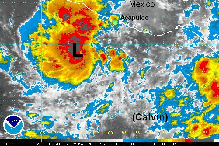
Calvin
- Tropical Inspector
- Site Admin
- Posts: 3682
- Joined: Tue Feb 20, 2007 2:28 pm
- Antispam: no
- Location: Under a palm tree
- Contact:
Calvin
Rich Johnson
Twitter: https://twitter.com/richjohnsonwx
Certified Broadcast Meteorologist - Hurricane Expert
Twitter: https://twitter.com/richjohnsonwx
Certified Broadcast Meteorologist - Hurricane Expert
- Tropical Inspector
- Site Admin
- Posts: 3682
- Joined: Tue Feb 20, 2007 2:28 pm
- Antispam: no
- Location: Under a palm tree
- Contact:
Re: Calvin south of Manzanillo
As expected the hurricane center upgraded to td 3-e and start advisories at 11 am edt.
Rich Johnson
Twitter: https://twitter.com/richjohnsonwx
Certified Broadcast Meteorologist - Hurricane Expert
Twitter: https://twitter.com/richjohnsonwx
Certified Broadcast Meteorologist - Hurricane Expert
Who is online
Users browsing this forum: No registered users and 0 guests