Colin

Tropical cyclone archives for the 2010 Atlantic hurricane season
User avatar
Tropical Inspector
Site Admin
Site Admin
Posts: 3630
Joined: Tue Feb 20, 2007 2:28 pm
Antispam: no
Location: Under a palm tree
Contact:

Re: Colin

Post by Tropical Inspector »

Saturday Late Afternoon Update

Colin acting erratically

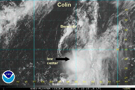
Colin has started moving again - now just south of due east. Visible satellite imagery show that the low is heading back under the convection. It also shows that the low level center is not very well organized. Colin is not getting any closer to Bermuda.

As of 4 pm edt / ast the tropical storm Colin was centered near 29.8° N / 66.3° W or about 200 miles just west of due south of Bermuda. Movment is east southeast at about 8 mph. Top sustained winds are estimated at 35 mph (NHC 40 mph) in the deep convection. Pressure 1012 mb.

:idea: Forecasts have been way off recently with Colin. They have not picked up the erratic motion over the past 12-24 hours.

Tropicast: Visible Floater Satellite
Image
Rich Johnson
Twitter: https://twitter.com/richjohnsonwx
Certified Broadcast Meteorologist - Hurricane Expert
User avatar
Tropical Inspector
Site Admin
Site Admin
Posts: 3630
Joined: Tue Feb 20, 2007 2:28 pm
Antispam: no
Location: Under a palm tree
Contact:

Re: Colin

Post by Tropical Inspector »

Sunday Morning Update

Colin still south of Bermuda

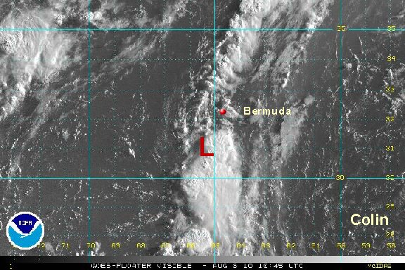
Colin's low level center is elongated as seen on radar. Rain will pick up on Bermuda later today as most of the unsettled weather with Colin is south of the circulation. It is still questionable if Bermuda will see tropical storm winds (sustained) as Colin moves near the island later today.

As of 7 am edt / ast the tropical storm Colin was centered near 30.9° N / 65.6° W or about 115 miles south southwest of Bermuda. Movment is north at about 7 mph. Top sustained winds are estimated at 35 mph (NHC 40 mph) in the deep convection. Pressure 1012 mb.

:idea: The center of Colin will pass near the island of Bermuda later on Sunday. After this is will become extratropical in a few days as it moves toward the north Atlantic.

Tropicast: Visible Floater Satellite
Image
Rich Johnson
Twitter: https://twitter.com/richjohnsonwx
Certified Broadcast Meteorologist - Hurricane Expert
User avatar
Tropical Inspector
Site Admin
Site Admin
Posts: 3630
Joined: Tue Feb 20, 2007 2:28 pm
Antispam: no
Location: Under a palm tree
Contact:

Re: Colin

Post by Tropical Inspector »

NHC finally agreed that Colin is not a storm on the 11 am advisory. 35 mph - tropical depression.
Rich Johnson
Twitter: https://twitter.com/richjohnsonwx
Certified Broadcast Meteorologist - Hurricane Expert
User avatar
Tropical Inspector
Site Admin
Site Admin
Posts: 3630
Joined: Tue Feb 20, 2007 2:28 pm
Antispam: no
Location: Under a palm tree
Contact:

Re: Colin

Post by Tropical Inspector »

Sunday Afternoon Update

Colin dissipating

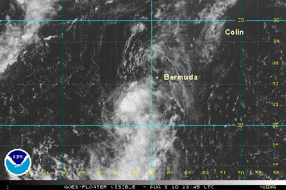
There is no longer any discernable low level circulation with Colin. A weak mid level spin is still south of Bermuda. Only scattered showers and storms remain with what is left of the circulation. Look for NHC to say that Colin has dissipated also. This will be our last update on Colin unless regeneration occurs.

Tropicast: Visible Floater Satellite
Image
Rich Johnson
Twitter: https://twitter.com/richjohnsonwx
Certified Broadcast Meteorologist - Hurricane Expert
Post Reply

Return to “2010 Atlantic Hurricane Season Archives”

Who is online

Users browsing this forum: No registered users and 0 guests