Fred

Tropical cyclone archives for the 2009 Atlantic hurricane season
User avatar
Tropical Inspector
Site Admin
Site Admin
Posts: 3682
Joined: Tue Feb 20, 2007 2:28 pm
Antispam: no
Location: Under a palm tree
Contact:

Re: Fred

Post by Tropical Inspector »

Saturday Morning Update

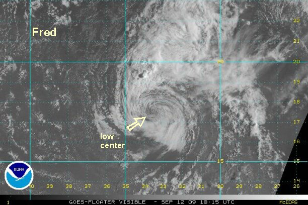
Fred in sorry shape

Fred is almost nothing more than a low level swirl of clouds now, except for some deep convection on banding well north of the center. A satellite estimate came in at 41 knots a few hours ago. With no convection near the center and the wekaening trend, we will now estimate 35 mph or just below tropical storm force.

At 8 am edt / ast Hurricane Fred was centered at 17.5° N / 33.5° W or about 695 miles west northwest Sal, Cape Verde Islands. Top sustained winds are estimated at 35 mph (NHC 45 mph). Fred is drifting barely north.

:idea: Note our position estimate is different from the hurricane center's because we are using different reference points.

Fred should start moving west northwest as a very weak low in the next day or two.

Tropicast: Visible Floater Satellite (6:15 am edt/ast)
Image
Rich Johnson
Twitter: https://twitter.com/richjohnsonwx
Certified Broadcast Meteorologist - Hurricane Expert
User avatar
Tropical Inspector
Site Admin
Site Admin
Posts: 3682
Joined: Tue Feb 20, 2007 2:28 pm
Antispam: no
Location: Under a palm tree
Contact:

Re: Fred

Post by Tropical Inspector »

The National Hurricane Center has finally downgraded to tropical depression of 35 mph. This will be the last advisory on Fred unless regeneration occurs.
Rich Johnson
Twitter: https://twitter.com/richjohnsonwx
Certified Broadcast Meteorologist - Hurricane Expert
User avatar
Tropical Inspector
Site Admin
Site Admin
Posts: 3682
Joined: Tue Feb 20, 2007 2:28 pm
Antispam: no
Location: Under a palm tree
Contact:

Re: Fred

Post by Tropical Inspector »

Fred has been trying to make a comeback over the past 24-36 hours. There have been brief small convective bursts around the circulation. Several hours ago, a rather impressive burst. If this burst was sustained we would have said that Fred is back again and should regain it's tropical depression status.

Forecast models try to reenergize Fred a little and move it west northwest in the general direction well north of the Leewards over the next couple of days.
Rich Johnson
Twitter: https://twitter.com/richjohnsonwx
Certified Broadcast Meteorologist - Hurricane Expert
User avatar
Tropical Inspector
Site Admin
Site Admin
Posts: 3682
Joined: Tue Feb 20, 2007 2:28 pm
Antispam: no
Location: Under a palm tree
Contact:

Re: Fred

Post by Tropical Inspector »

As of Midday Wednesday, Fred's circulation is still firing up thundershowers on the north side. Visible satellite imagery shows that the low level circulation is still intact, but weak.
Rich Johnson
Twitter: https://twitter.com/richjohnsonwx
Certified Broadcast Meteorologist - Hurricane Expert
User avatar
Tropical Inspector
Site Admin
Site Admin
Posts: 3682
Joined: Tue Feb 20, 2007 2:28 pm
Antispam: no
Location: Under a palm tree
Contact:

Re: Fred

Post by Tropical Inspector »

It appears that the remnants of Fred will increase chances of rain to the northern half of the Bahamas over the weekend. Right now the circulation with Fred is centered a few hundred miles east of the central Bahamas moving west northwest.
Rich Johnson
Twitter: https://twitter.com/richjohnsonwx
Certified Broadcast Meteorologist - Hurricane Expert
User avatar
Tropical Inspector
Site Admin
Site Admin
Posts: 3682
Joined: Tue Feb 20, 2007 2:28 pm
Antispam: no
Location: Under a palm tree
Contact:

Re: Fred

Post by Tropical Inspector »

The latest Quickscat satellite estimates show that the remnants of Fred still do not have a closed low at the surface. Some showers and storms are associated with this system and are likely to affect the northern Bahamas and Florida into the weekend / early next week. Rainfall will be enhanced as this feature moves through.
Rich Johnson
Twitter: https://twitter.com/richjohnsonwx
Certified Broadcast Meteorologist - Hurricane Expert
User avatar
Tropical Inspector
Site Admin
Site Admin
Posts: 3682
Joined: Tue Feb 20, 2007 2:28 pm
Antispam: no
Location: Under a palm tree
Contact:

Re: Fred

Post by Tropical Inspector »

The circulation with Fred is still depicted as a strong tropical wave on Quickscat satellite. A new burst of heavy showers and storms are associated with it. There is still some chance of minimal development as it increases rain chances from the northern Bahamas / Florida north to the Carolinas over the next few days.
Rich Johnson
Twitter: https://twitter.com/richjohnsonwx
Certified Broadcast Meteorologist - Hurricane Expert
Post Reply

Return to “2009 Atlantic Hurricane Season Archives”

Who is online

Users browsing this forum: No registered users and 0 guests